Kaukauna (town), Wisconsin
| Kaukauna, Wisconsin | |
|---|---|
| Town | |
 Location of the town of Kaukauna, Wisconsin | |
| Coordinates: 44°20′N 88°13′W / 44.333°N 88.217°WCoordinates: 44°20′N 88°13′W / 44.333°N 88.217°W | |
| Country | United States |
| State | Wisconsin |
| County | Outagamie |
| Organized | April 7, 1842 |
| Area | |
| • Total | 18.1 sq mi (46.8 km2) |
| • Land | 17.8 sq mi (46.0 km2) |
| • Water | 0.3 sq mi (0.8 km2) |
| Elevation[1] | 679 ft (207 m) |
| Population (2010) | |
| • Total | 1,238 |
| • Density | 64.3/sq mi (24.8/km2) |
| Time zone | Central (CST) (UTC-6) |
| • Summer (DST) | CDT (UTC-5) |
| Area code(s) | 920 |
| FIPS code | 55-38825[2] |
| GNIS feature ID | 1583464[1] |
Kaukauna is a town in Outagamie County, Wisconsin, United States. The population was 1,238 at the 2010 census. The unincorporated community of Sniderville is located partially in the town.
History
The Town of Kaukauna, originally named Kaukaulan (though other sources have more rarely referred to it in its earliest days as Grand Kaukalan or [Grand] Cacalin) organized as a town on April 7, 1842.[3] At the time of its formation, it was wholly a part of Brown County; Outagamie County would not be formed until 1851. The town originally comprised all of future Outagamie County, and parts of Brown County around Wrightstown.[3]
As settlers arrived, the Towns of Grand Chute and Lansing were split off from Kaukauna in 1849. The 1849 split left Kaukauna to administer its present day Town area, all of the area comprising the Town of Vandenbroek, and portions of the present-day Town of Buchanan. The portion which went to the Town of Buchanan was portioned off in 1858. In 1885, the adjacent City of Kaukauna was removed from the town when it incorporated.[4] The last major change was the Town of Vandenbroek divided off in 1902 into a new township, giving the Town of Kaukauna its rough size as it exists today. On February 28, 2002, further parts of the town were annexed by Wrightstown, Wisconsin.[5]
Geography
According to the United States Census Bureau, in 2000 the town had a total area of 18.1 square miles (46.8 km²). 17.8 square miles (46.0 km²) of it is land and 0.3 square miles (0.8 km²) of it (1.66%) is water.
Demographics
As of the census of 2000, there were 1,142 people, 370 households, and 311 families residing in the town. The population density was 64.3 people per square mile (24.8/km²). There were 378 housing units at an average density of 8.2 persons/km² (21.3 persons/sq mi). The racial makeup of the town was 97.55% White, 0.09% African American, 1.93% Native American, 0.09% Asian, 0.00% Pacific Islander, 0.00% from other races, and 0.35% from two or more races. 0.53% of the population were Hispanic or Latino of any race.
There were 370 households out of which 44.1% had children under the age of 18 living with them, 75.9% were married couples living together, 4.3% have a woman whose husband does not live with her, and 15.9% were non-families. 12.4% of all households were made up of individuals and 3.5% had someone living alone who was 65 years of age or older. The average household size was 3.02 and the average family size was 3.32.
In the town the population was spread out with 31.1% under the age of 18, 6.5% from 18 to 24, 30.5% from 25 to 44, 22.4% from 45 to 64, and 9.5% who were 65 years of age or older. The median age was 36 years. For every 100 females there were 100.7 males. For every 100 females age 18 and over, there were 98.2 males.
The median income for a household in the town was $61,696, and the median income for a family was $63,625. Males had a median income of $41,010 versus $26,111 for females. The per capita income for the town was $20,881. 1.7% of the population and 1.0% of families were below the poverty line. Out of the total people living in poverty, 2.7% are under the age of 18 and 0.0% are 65 or older.
Notable people
- Anton M. Miller, Wisconsin farmer and politician, lived in the town.[6]
- William M. Rohan, Wisconsin farmer and politician, was chairman and treasurer of the town.
References
- 1 2 "US Board on Geographic Names". United States Geological Survey. 2007-10-25. Retrieved 2008-01-31.
- ↑ "American FactFinder". United States Census Bureau. Retrieved 2008-01-31.
- 1 2 Outagamie County State Centennial Committee (1949). "Land of the Fox, Saga of Outagamie County" (PDF). Retrieved 2016-09-28.
- ↑ History of the Town of Kaukauna
- ↑ http://www.legis.state.wi.us/lrb/bb/05bb/744-779.pdf
- ↑ 'Wisconsin Blue Book 1931,' Biographical Sketch of Anton M. Miller, pg. 203
External links
| Core cities |  | |
|---|---|---|
| Largest municipalities over 10,000 in 2010 | ||
| Municipalities under 10,000 in 2010 |
| |
| Counties | ||
| ||
Municipalities and communities of Outagamie County, Wisconsin, United States | ||
|---|---|---|
| Cities | 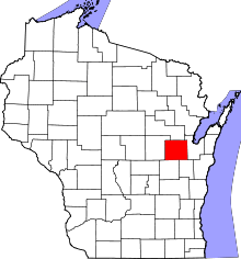 | |
| Villages | ||
| Towns | ||
| CDP | ||
| Unincorporated communities | ||
| Indian reservation | ||
| Ghost towns | ||
| Footnotes | ‡This populated place also has portions in an adjacent county or counties | |