Dale (CDP), Wisconsin
| Dale | |
|---|---|
| Census-designated place | |
|
Downtown Dale | |
| Coordinates: 44°16′23″N 88°40′42″W / 44.27306°N 88.67833°WCoordinates: 44°16′23″N 88°40′42″W / 44.27306°N 88.67833°W | |
| Country | United States |
| State | Wisconsin |
| County | Outagamie |
| Area | |
| • Total | 1.492 sq mi (3.86 km2) |
| • Land | 1.492 sq mi (3.86 km2) |
| • Water | 0 sq mi (0 km2) |
| Elevation[1] | 814 ft (248 m) |
| Population (2010) | |
| • Total | 528 |
| • Density | 350/sq mi (140/km2) |
| Time zone | Central (CST) (UTC-6) |
| • Summer (DST) | CDT (UTC-5) |
| ZIP Codes | 54931 |
| Area code(s) | 920 |
| FIPS code | Class Code U6[1] |
| GNIS feature ID | 1563669[1] |

Dale is an unincorporated census-designated place in the town of Dale in Outagamie County, Wisconsin, United States. It is located at the intersection of Wisconsin Highway 96 and County T.[2] As of the 2010 census, its population was 528.[3]
History
Ssettlers who would plat the land comprising the community of Dale arrived between 1851 and 1853, and approximately twenty families arrived between the fall of 1853 and June 1854, establishing a solid population.[4] Dale was founded and platted along the proposed Manitowoc and Mississippi Railroad line,[5] which consolidated with the Wisconsin Central Railroad in 1871.[6] Rail construction on the right of way by the Wisconsin Central reached Dale in 1872.[7]
Early in its history, the community was called Poker Flat[8] in addition to Dale, for what a 1923 newspaper article terms "an unknown reason".[9]
20th century
On September 3, 1974, one of three contractors installing curb and gutter pulled a gas line apart under Dale's Appleton State Bank, while digging a storm sewer trench with a backhoe. Natural gas leaked into the basement of the bank, and caused an explosion at 12:50 pm. An assistant bank manager who was preparing to re-open the bank for business hours was flung from the building by the force of the blast, and died of head and chest injuries five hours after the blast. Another person in a nearby building suffered two broken legs and a shoulder injury.[8][10]
The explosion destroyed the bank building and Dale's post office, situated next door to the bank. Postal service was temporarily run out of Dale's town hall, and Appleton State Bank business out of a trailer, until both could have new buildings constructed.[8]
-

Post office, constructed 1974
-

Entrance sign
-

Town hall for the town of Dale
References
- 1 2 3 "Dale, Wisconsin". Wisconsin Hometown Locator. Retrieved 20 April 2010.
- ↑ "Location of Dale". Mapquest. Retrieved 20 April 2010.
- ↑ "American FactFinder". U.S. Census Bureau. Retrieved 30 March 2011.
- ↑ "History of Dale, Wisconsin". history.rays-place.com. Retrieved 2016-02-14.
- ↑ LLC., Historic Map Works. "Wisconsin 1857 Milwaukee and Superior Railroads 17x12, Atlas: Wisconsin 1857 Milwaukee and Superior Railroads, Wisconsin Historical Map". www.historicmapworks.com. Retrieved 2016-02-15.
- ↑ Matteson, Clark S. (1893-01-01). The History of Wisconsin: From Prehistoric to Present Periods ; the Story of the State in Interspersed with Realistic and Romantic Events. Wisconsin Historical Publishing Company.
- ↑ "Dale and Medina Grew From Good Farmland". New London Press Gazette. Retrieved 2016-02-14.
- 1 2 3 Zehner, David J. (1989). The History of Dale (Poker Flat) and Medina (Young's Corner) Wisconsin. Neenah, Wisconsin: Jon Habermann. ASIN B00072ETMG.
- ↑ "The Post-Crescent from Appleton, Wisconsin · Page 7". Newspapers.com. 1923-07-16. Retrieved 2016-02-14.
- ↑ "4 Sep 1974, Page 28 - The La Crosse Tribune at Newspapers.com". Newspapers.com. Retrieved 2016-05-20.
Municipalities and communities of Outagamie County, Wisconsin, United States | ||
|---|---|---|
| Cities | 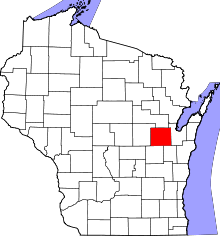 | |
| Villages | ||
| Towns | ||
| CDP | ||
| Unincorporated communities | ||
| Indian reservation | ||
| Ghost towns | ||
| Footnotes | ‡This populated place also has portions in an adjacent county or counties | |