Grand Chute, Wisconsin
| Town of Grand Chute, Wisconsin | |
|---|---|
| Town | |
| Motto: Tradition and Progress | |
 Location of Grand Chute within Wisconsin | |
| Coordinates: 44°16′54″N 88°26′17″W / 44.28167°N 88.43806°WCoordinates: 44°16′54″N 88°26′17″W / 44.28167°N 88.43806°W | |
| Country | United States |
| State | Wisconsin |
| County | Outagamie |
| Surrounding Towns | Center, Ellington, Greenville |
| Established | April 3, 1849 |
| Government | |
| • Type | Town Board |
| • Town Chairman | David A. Schowalter[1] |
| Area | |
| • Town | 25.0 sq mi (64.6 km2) |
| • Land | 24.9 sq mi (64.5 km2) |
| • Water | 0.1 sq mi (0.2 km2) |
| Elevation | 790 ft (241 m) |
| Population (2010) | |
| • Town | 20,919 |
| • Density | 840.1/sq mi (324.3/km2) |
| • Metro | 360,000 |
| Time zone | CST (UTC-6) |
| • Summer (DST) | CDT (UTC-5) |
| ZIP Code | 54913, 54914 |
| Area code(s) | 920 |
| FIPS code | 55-30075[2] |
| GNIS feature ID | 1583295[3] |
| Website | www.grandchute.net |
Grand Chute (French: great fall or "large rapids") is a town in Outagamie County, Wisconsin, United States. The unincorporated community of Apple Creek is partially located in the town and the ghost towns of Grand Chute and Lawesburg are located in the town. It is perhaps best known as the birthplace of U.S. Senator Joseph McCarthy.
At 20,919, Grand Chute was the largest town by population in the state of Wisconsin as of the 2010 census. Second largest was the town of Somers, now that the former town of Menasha has incorporated to become the village of Fox Crossing in 2016.
History
The Town of Grand Chute was formed on April 3, 1849 inside what was then Brown County, Wisconsin. By state legislative act, Grand Chute was split off of the Town of Kaukalin (later Kaukauna). The Town of Grand Chute's boundary at its establishment comprised a much larger area than it has today, formed by what today are the towns of Dale, Hortonia, Greenville, Ellington, and present-day Grand Chute.[4][5] By 1850, due to a large influx of new settlers, the towns of Hortonia (which included Dale at the time), Greenville, and Ellington had all been split away from Grand Chute to form new towns.[5]
Outagamie County was set up by law in February 1851 and had its county government formally organized on April 1, 1851. At that time, the Town of Grand Chute (which by definition changed from Brown to Outagamie County) was established as the seat of county government affairs.[6][7]
Grand Chute's population in 1984 was estimated to be 10,874.[8] In March of that year, residents overwhelmingly approved using town funds to attempt incorporation into a village. After town hearings in late 1984, Grand Chute petitioned to the State of Wisconsin. The Wisconsin Department of Development denied the town's request to incorporate on March 25, 1985. At the time of the denial, the DOD's findings were that some (but not necessarily all) government services would be better provided by the City of Appleton, and that the proposed village was not compact nor homogenous.[9]
Geography
According to the United States Census Bureau, the town has a total area of 25.0 square miles (64.6 km²), of which 24.9 square miles (64.5 km²) is land and 0.1 square mile (0.2 km²) (0.32%) is water.
Grand Chute is the largest town in Wisconsin, both in terms of population (20,919 at the 2010 census)[10] and valuation (over $2.4 billion).[11] It is part of the Fox Cities metroplex that includes Oshkosh, Neenah, Menasha, and Appleton.
Demographics
2000 census
As of the census[2] of 2000, there were 18,392 people, 7,586 households, and 4,688 families residing in the town. The population estimate in 2008 was about 27,000. The population density was 739.1 people per square mile (285.3/km²). There were 7,965 housing units at an average density of 320.1 per square mile (123.6/km²). The racial makeup of the town was 94.28% White, 0.77% African American, 0.40% Native American, 1.52% Asian, 0.08% Pacific Islander, 1.87% from other races, and 1.08% from two or more races. 3.53% of the population were Hispanic or Latino of any race.
There were 7,586 households out of which 29.6% had children under the age of 18 living with them, 53.2% were married couples living together, 5.9% had a female householder with no husband present, and 38.2% were non-families. 28.6% of all households were made up of individuals and 8.5% had someone living alone who was 65 years of age or older. The average household size was 2.38 and the average family size was 3.00.
In the town the population was spread out with 23.4% under the age of 18, 11.2% from 18 to 24, 31.2% from 25 to 44, 22.6% from 45 to 64, and 11.6% who were 65 years of age or older. The median age was 35 years. For every 100 females there were 99.2 males. For every 100 females age 18 and over, there were 96.6 males.
The median income for a household in the town was $50,772, and the median income for a family was $61,780. Males had a median income of $42,084 versus $27,346 for females. The per capita income for the town was $25,189. 5.3% of the population and 2.7% of families were below the poverty line, including 4.7% of those under the age of 18 and 7.5% of those ages 65 and older.
2010 census
As of the census[12] of 2010, there were 20,919 people, 9,378 households, and 5,390 families residing in the town. The population density was 836.8 people per square mile (323.8/km²). There were 9,932 housing units at an average density of 397.3 per square mile (153.7/km²). The racial makeup of the town was 89.3% White, 1.4% African American, 0.4% Native American, 4.5% Asian, 0.1% Pacific Islander, 2.5% from other races, and 1.6% from two or more races. 4.9% of the population were Hispanic or Latino of any race.
There were 9,378 households out of which 25.0% had children under the age of 18 living with them, 45.9% were married couples living together, 7.9% had a female householder with no husband present, and 42.5% were non-families. 32.9% of all households were made up of individuals and 10.1% had someone living alone who was 65 years of age or older. The average household size was 2.21 and the average family size was 2.84.
In the town the population was spread out with 20.0% under the age of 18, 10.3% from 18 to 24, 27.3% from 25 to 44, 28.0% from 45 to 64, and 14.4% who were 65 years of age or older. The median age was 38.8 years. For every 100 females there were 94.6 males.
The median income for a household in the town was $52,813, and the median income for a family was $69,224. Males had a median income of $50,483 versus $37,073 for females. The per capita income for the town was $32,557. 8.9% of the population and 3.4% of families were below the poverty line. 9.3% of those under the age of 18 and 5.6% of those 65 and older were living below the poverty line.
Transportation
The town is served by Valley Transit, a network of bus lines serving the Fox Valley. There are also several taxi operators in the town. Valley Transit operates routes that generally operate from as early as 5:45 AM until as late as 10:40 PM Monday through Saturday. Frequencies are usually every hour and every half-hour on certain routes during peak morning and afternoon times on weekdays. There is no service on Sunday. Greyhound and Lamers offer intercity buses serving such locations as Green Bay, Madison, Oshkosh, Fond du Lac, Milwaukee, and Chicago.
Roads
| | Interstate 41 Northbound routes to Green Bay. Southbound I-41 routes to Oshkosh, Fond du Lac, and Milwaukee. This is a full interstate grade freeway that runs on the west and north sides of Appleton. It has 8 exits serving the Appleton area (from South to North) with 5 being in Grand Chute at:
Hwy BB Prospect Ave. (Exit 136) WIS 125/Hwy CA College Ave.(Exit 137), WIS 96 Wisconsin Ave. (Exit 138), WIS 15/Hwy OO Northland Ave.(Exit 139), WIS 47 Richmond St. (Exit 142) |
| | US 41 runs entirely concurrent with Interstate 41 through the city of Appleton. |
| | WIS 15 Westbound routes to New London. This is partly Northland Ave. |
| | WIS 96 travels west to Fremont and travels east to Little Chute and Kaukauna. This is Wisconsin Ave. |
| WIS 125 travels between US 41 and WIS 47 on College Ave. College Ave. west of US 41 is Hwy CA and heads to Appleton International Airport. |
Airport
The Appleton International Airport (ATW) is located at the west end of College Avenue, 2 miles west of Interstate 41. The airport is served by 3 airlines who service 8 destinations around the United States.
Points of interest
- Butte des Morts Country Club
- Fox River Mall and surrounding shopping district (the largest concentration of retail in Wisconsin)[13]
- Fox Valley Technical College
- Gordon Bubolz Nature Preserve
- Grand Chute Trail System
- John Birch Society
- Plamann Park[14]
- Neuroscience Group Field at Fox Cities Stadium, home of the Wisconsin Timber Rattlers, a Class A affiliate of the Milwaukee Brewers
Gallery
 WIS Highway 47
 Town Hall
 Water tower
Notable people
- Clinton B. Ballard, Wisconsin State Assemblyman
- Louis L. Jabas, Wisconsin State Assemblyman
- August W. Laabs, Wisconsin State Assemblyman
- Joseph McCarthy, U.S. Senator
- George J. Schneider, U.S. Representative
References
- ↑ "Town Board". Town of Grand Chute. Retrieved 18 July 2014.
- 1 2 "American FactFinder". United States Census Bureau. Retrieved 2008-01-31.
- ↑ "US Board on Geographic Names". United States Geological Survey. 2007-10-25. Retrieved 2008-01-31.
- ↑ "History of Grand Chute, Wisconsin". history.rays-place.com. Retrieved 2016-09-28.
- 1 2 Outagamie County State Centennial Committee (1949). "Land of the Fox, Saga of Outagamie County" (PDF). Retrieved 2016-09-28.
- ↑ "History of Outagamie County - Part 2". www.foxvalleymemory.org. Retrieved 2016-09-28.
- ↑ "WI: Individual County Chronologies". publications.newberry.org. Retrieved 2016-09-28.
- ↑ The State of Wisconsin Blue Book. Wisconsin Legislative Reference Bureau, distributed by Document Sales. 1985-01-01.
- ↑ "Green Bay Press-Gazette from Green Bay, Wisconsin · Page 4". Newspapers.com. 1985-03-26. Retrieved 2016-10-02.
- ↑ "American Fact Finder". Retrieved October 22, 2013.
- ↑ "Town of Grand Chute website". Retrieved April 9, 2009.
- ↑ "American Fact Finder". United States Census Bureau. Retrieved 18 July 2014.
- ↑ "Fox Cities Convention & Visitors Bureau". Retrieved April 9, 2009.
- ↑ "Plamann Park website". Retrieved April 9, 2009.
External links
| Core cities |  | |
|---|---|---|
| Largest municipalities over 10,000 in 2010 | ||
| Municipalities under 10,000 in 2010 |
| |
| Counties | ||
| ||
Municipalities and communities of Outagamie County, Wisconsin, United States | ||
|---|---|---|
| Cities | 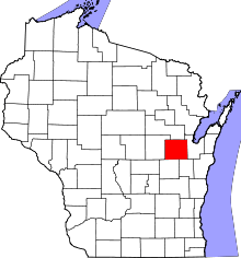 | |
| Villages | ||
| Towns | ||
| CDP | ||
| Unincorporated communities | ||
| Indian reservation | ||
| Ghost towns | ||
| Footnotes | ‡This populated place also has portions in an adjacent county or counties | |