Lime Rock, Wisconsin
| Lime Rock, Wisconsin | |
|---|---|
| Ghost Town | |
 Lime Rock, Wisconsin Location of Lime Rock, Wisconsin | |
| Coordinates: 44°30′03.52″N 88°21′03.77″W / 44.5009778°N 88.3510472°WCoordinates: 44°30′03.52″N 88°21′03.77″W / 44.5009778°N 88.3510472°W | |
| Country | United States |
| State | Wisconsin |
| County | Outagamie |
| Elevation[1] | 851 ft (259 m) |
| Time zone | Central (CST) (UTC-6) |
| • Summer (DST) | CDT (UTC-5) |
| ZIP Codes | 54165 |
| Area code(s) | (920) |
Lime Rock is a ghost town in Outagamie County, Wisconsin, United States. Once located in the town of Seymour and the town of Osborn, the ghost town has no surviving buildings.
Geography
Lime Rock was located at 44°30′03.52″N 88°21′03.77″W / 44.5009778°N 88.3510472°W (44.500978, -88.351047),[2] with an elevation of 851 feet (259m).
References
- ↑ "US Board on Geographic Names". United States Geological Survey. 2007-10-25. Retrieved 2008-01-31.
- ↑ "US Gazetteer files: 2010, 2000, and 1990". United States Census Bureau. 2011-02-12. Retrieved 2011-04-23.
Municipalities and communities of Outagamie County, Wisconsin, United States | ||
|---|---|---|
| Cities | 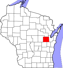 | |
| Villages | ||
| Towns | ||
| CDP | ||
| Unincorporated communities | ||
| Indian reservation | ||
| Ghost towns | ||
| Footnotes | ‡This populated place also has portions in an adjacent county or counties | |
This article is issued from Wikipedia - version of the 9/4/2016. The text is available under the Creative Commons Attribution/Share Alike but additional terms may apply for the media files.