Combined Locks, Wisconsin
| Combined Locks, Wisconsin | |
|---|---|
| Village | |
 Location of Combined Locks, Wisconsin | |
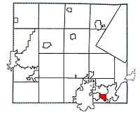 Location of Combined Locks, Wisconsin in Outagamie County | |
| Coordinates: 44°16′N 88°19′W / 44.267°N 88.317°WCoordinates: 44°16′N 88°19′W / 44.267°N 88.317°W | |
| Country | United States |
| State | Wisconsin |
| County | Outagamie |
| Area[1] | |
| • Total | 1.89 sq mi (4.90 km2) |
| • Land | 1.71 sq mi (4.43 km2) |
| • Water | 0.18 sq mi (0.47 km2) |
| Elevation[2] | 725 ft (221 m) |
| Population (2010)[3] | |
| • Total | 3,328 |
| • Estimate (2012[4]) | 3,388 |
| • Density | 1,946.2/sq mi (751.4/km2) |
| Time zone | Central (CST) (UTC-6) |
| • Summer (DST) | CDT (UTC-5) |
| Area code(s) | 920 |
| FIPS code | 55-16500[5] |
| GNIS feature ID | 1563292[2] |
| Website | http://www.combinedlocks.org/ |
Combined Locks is a village in Outagamie County, Wisconsin, United States. The population was 3,328 at the 2010 census.
History
A post office called Combined Locks has been in operation since 1892.[6] The village was named from the canal locks near the town site.[7]
Geography
Combined Locks is located at 44°16′N 88°19′W / 44.267°N 88.317°W (44.2649, -88.3120).[8]
According to the United States Census Bureau, the village has a total area of 1.89 square miles (4.90 km2), of which, 1.71 square miles (4.43 km2) of it is land and 0.18 square miles (0.47 km2) is water.[1]
Demographics
| Historical population | |||
|---|---|---|---|
| Census | Pop. | %± | |
| 1930 | 545 | — | |
| 1940 | 625 | 14.7% | |
| 1950 | 720 | 15.2% | |
| 1960 | 1,421 | 97.4% | |
| 1970 | 2,771 | 95.0% | |
| 1980 | 2,573 | −7.1% | |
| 1990 | 2,190 | −14.9% | |
| 2000 | 2,422 | 10.6% | |
| 2010 | 3,328 | 37.4% | |
| Est. 2015 | 3,532 | [9] | 6.1% |
2010 census
As of the census[3] of 2010, there were 3,328 people, 1,232 households, and 953 families residing in the village. The population density was 1,946.2 inhabitants per square mile (751.4/km2). There were 1,263 housing units at an average density of 738.6 per square mile (285.2/km2). The racial makeup of the village was 96.7% White, 0.2% African American, 0.6% Native American, 1.5% Asian, 0.1% Pacific Islander, 0.3% from other races, and 0.6% from two or more races. Hispanic or Latino of any race were 2.0% of the population.
There were 1,232 households of which 39.4% had children under the age of 18 living with them, 68.6% were married couples living together, 5.4% had a female householder with no husband present, 3.3% had a male householder with no wife present, and 22.6% were non-families. 18.8% of all households were made up of individuals and 8.5% had someone living alone who was 65 years of age or older. The average household size was 2.70 and the average family size was 3.12.
The median age in the village was 38.8 years. 28.5% of residents were under the age of 18; 5.1% were between the ages of 18 and 24; 27.3% were from 25 to 44; 25% were from 45 to 64; and 14.2% were 65 years of age or older. The gender makeup of the village was 50.1% male and 49.9% female.
2000 census
As of the census[5] of 2000, there were 2,422 people, 884 households, and 716 families residing in the village. The population density was 1,591.3 people per square mile (615.2/km²). There were 903 housing units at an average density of 593.3 per square mile (229.4/km²). The racial makeup of the village was 98.27% White, 0.17% African American, 0.41% Native American, 0.45% Asian, 0.25% from other races, and 0.45% from two or more races. Hispanic or Latino of any race were 1.24% of the population.
There were 884 households out of which 37.1% had children under the age of 18 living with them, 72.7% were married couples living together, 6.0% had a female householder with no husband present, and 18.9% were non-families. 15.6% of all households were made up of individuals and 5.8% had someone living alone who was 65 years of age or older. The average household size was 2.74 and the average family size was 3.06.
In the village the population was spread out with 27.8% under the age of 18, 6.1% from 18 to 24, 31.6% from 25 to 44, 24.2% from 45 to 64, and 10.3% who were 65 years of age or older. The median age was 36 years. For every 100 females there were 101.2 males. For every 100 females age 18 and over, there were 98.8 males.
The median income for a household in the village was $53,125, and the median income for a family was $56,131. Males had a median income of $42,135 versus $25,583 for females. The per capita income for the village was $24,090. About 0.5% of families and 0.8% of the population were below the poverty line, including none of those under age 18 and 4.8% of those age 65 or over.
References
- 1 2 "US Gazetteer files 2010". United States Census Bureau. Archived from the original on 2012-07-14. Retrieved 2012-11-18.
- 1 2 "US Board on Geographic Names". United States Geological Survey. 2007-10-25. Retrieved 2008-01-31.
- 1 2 "American FactFinder". United States Census Bureau. Retrieved 2012-11-18.
- ↑ "Population Estimates". United States Census Bureau. Archived from the original on 2013-06-17. Retrieved 2013-06-24.
- 1 2 "American FactFinder". United States Census Bureau. Archived from the original on 2013-09-11. Retrieved 2008-01-31.
- ↑ "Outagamie County". Jim Forte Postal History. Retrieved 28 February 2015.
- ↑ Chicago and North Western Railway Company (1908). A History of the Origin of the Place Names Connected with the Chicago & North Western and Chicago, St. Paul, Minneapolis & Omaha Railways. p. 58.
- ↑ "US Gazetteer files: 2010, 2000, and 1990". United States Census Bureau. 2011-02-12. Retrieved 2011-04-23.
- ↑ "Annual Estimates of the Resident Population for Incorporated Places: April 1, 2010 to July 1, 2015". Retrieved July 2, 2016.
- ↑ "Census of Population and Housing". Census.gov. Archived from the original on April 22, 2013. Retrieved June 4, 2015.
External links
| Core cities |  | |
|---|---|---|
| Largest municipalities over 10,000 in 2010 | ||
| Municipalities under 10,000 in 2010 |
| |
| Counties | ||
| ||
Municipalities and communities of Outagamie County, Wisconsin, United States | ||
|---|---|---|
| Cities | 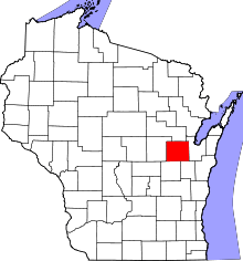 | |
| Villages | ||
| Towns | ||
| CDP | ||
| Unincorporated communities | ||
| Indian reservation | ||
| Ghost towns | ||
| Footnotes | ‡This populated place also has portions in an adjacent county or counties | |