Center, Outagamie County, Wisconsin
| Center, Wisconsin | |
|---|---|
| Town | |
|
Town hall | |
| Motto: Wide Awake Forward | |
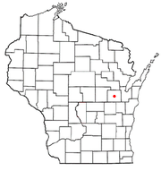 Location of Center, Wisconsin | |
| Coordinates: 44°22′34″N 88°26′25″W / 44.37611°N 88.44028°WCoordinates: 44°22′34″N 88°26′25″W / 44.37611°N 88.44028°W | |
| Country | United States |
| State | Wisconsin |
| County | Outagamie |
| Area | |
| • Total | 35.7 sq mi (92.3 km2) |
| • Land | 35.7 sq mi (92.3 km2) |
| • Water | 0.0 sq mi (0.0 km2) |
| Elevation[1] | 801 ft (244 m) |
| Population (2000) | |
| • Total | 3,163 |
| • Density | 88.7/sq mi (34.3/km2) |
| Time zone | Central (CST) (UTC-6) |
| • Summer (DST) | CDT (UTC-5) |
| FIPS code | 55-13600[2] |
| GNIS feature ID | 1582941[1] |

Center is a town in Outagamie County, Wisconsin, United States. The population was 3,163 at the 2000 census. The unincorporated communities of Mackville and Five Corners are located partially within the town. The unincorporated communities of Center Valley, Hamples Corner, and Twelve Corners are also located in the town.
History
The Town of Center began as the Town of Lansing, organized on September 12, 1849. It included the modern day areas of the towns of Freedom and Center, and "territory lying to the north that was sparsely settled". The town of Freedom was established as a new town split off from the town of Lansing on June 5, 1852.[3] When the split occurred, Freedom took with it the officers of the town of Lansing, as well as the town seat, and many of its residents and public improvements.[4]
A meeting was held on July 5, 1852 to fill the vacancies for the officers of the existing town of Lansing, although in practice this was the reorganization of a new town also called Lansing since there were no officers to provide continuity.[3] The legality of the action was apparently questioned. An April 30, 1853 resolution of the board of supervisors of the town declared that the state of Wisconsin had granted legality to "acts of the town officers of last year", and also had granted the request of the board to have the name of the town changed from Lansing to Center, effective April 1, 1853.[4]
Geography
According to the United States Census Bureau, the town has a total area of 35.7 square miles (92.4 km²), all of it land.
Demographics
As of the census[2] of 2000, there were 3,163 people, 1,095 households, and 913 families residing in the town. The population density was 88.7 people per square mile (34.2/km²). There were 1,105 housing units at an average density of 31.0 per square mile (12.0/km²). The racial makeup of the town was 98.89% White, 0.09% African American, 0.54% Native American, 0.09% Asian, 0.03% from other races, and 0.35% from two or more races. Hispanic or Latino of any race were 0.66% of the population.
There were 1,095 households out of which 38.8% had children under the age of 18 living with them, 77.4% were married couples living together, 3.2% had a female householder with no husband present, and 16.6% were non-families. 13.6% of all households were made up of individuals and 4.4% had someone living alone who was 65 years of age or older. The average household size was 2.89 and the average family size was 3.19.
In the town the population was spread out with 27.1% under the age of 18, 7.1% from 18 to 24, 29.5% from 25 to 44, 27.9% from 45 to 64, and 8.4% who were 65 years of age or older. The median age was 38 years. For every 100 females there were 109.5 males. For every 100 females age 18 and over, there were 108.8 males.
The median income for a household in the town was $58,092, and the median income for a family was $61,152. Males had a median income of $41,140 versus $26,080 for females. The per capita income for the town was $23,553. None of the families and 0.4% of the population were living below the poverty line, including no under eighteens and none of those over 64.
References
- 1 2 "US Board on Geographic Names". United States Geological Survey. 2007-10-25. Retrieved 2008-01-31.
- 1 2 "American FactFinder". United States Census Bureau. Archived from the original on 2013-09-11. Retrieved 2008-01-31.
- 1 2 Outagamie County State Centennial Committee (1949). "Land of the Fox, Saga of Outagamie County" (PDF). Retrieved 2016-09-28.
- 1 2 "History of Center, Wisconsin". history.rays-place.com. Retrieved 2016-09-29.
| Core cities |  | |
|---|---|---|
| Largest municipalities over 10,000 in 2010 | ||
| Municipalities under 10,000 in 2010 |
| |
| Counties | ||
| ||
Municipalities and communities of Outagamie County, Wisconsin, United States | ||
|---|---|---|
| Cities | 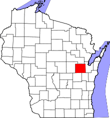 | |
| Villages | ||
| Towns | ||
| CDP | ||
| Unincorporated communities | ||
| Indian reservation | ||
| Ghost towns | ||
| Footnotes | ‡This populated place also has portions in an adjacent county or counties | |