Sugar Bush, Outagamie County, Wisconsin
| Sugar Bush, Wisconsin | |
|---|---|
| Unincorporated community | |
| Country | United States |
| State | Wisconsin |
| County | Outagamie |
| Elevation | 830 ft (250 m) |
| Time zone | Central (CST) (UTC-6) |
| • Summer (DST) | CDT (UTC-5) |
Sugar Bush is an unincorporated community located entirely within the town of Maple Creek in northwest Outagamie County, Wisconsin, United States.[1] Sugar Bush is classified as a Class U6 Community by the USGS, being a populated place located wholly or substantially outside the boundaries of any incorporated place or CDP with a recognized authoritative common name.
Sugar Bush is located 6 miles north of New London, 10 miles south of Clintonville and 40 miles west of Green Bay.
Postal service is provided by the New London post office, ZIP code 54961.
History
A post office called Sugar Bush was in operation from 1858 until 1972.[2] The community was named from a grove of sugar maples near the town site.[3]
Geography
Sugar Bush is located at 44°28′54″N 88°44′9″W / 44.48167°N 88.73583°W (44.4816467, -88.7359322), and the elevation is 830 feet (253 m).[4]
Education
The School District of New London operates an elementary school in Sugar Bush.
Transportation
Sugar Bush is located on Outagamie County Highway WW, immediately east of U.S. Highway 45, a major north-south corridor in the State of Wisconsin, and just west of Outagamie County Highway D.
References
- ↑ "Sugar Bush, Wisconsin". Geographic Names Information System. United States Geological Survey.
- ↑ "Outagamie County". Jim Forte Postal History. Retrieved 21 March 2015.
- ↑ Chicago and North Western Railway Company (1908). A History of the Origin of the Place Names Connected with the Chicago & North Western and Chicago, St. Paul, Minneapolis & Omaha Railways. p. 128.
- ↑ GNIS Detail: Sugar Bush, Wisconsin
External links
- New London Press-Star Newspaper
- Sugar Bush Elementary School, School District of New London
- USGS GNIS in Google Map
Municipalities and communities of Outagamie County, Wisconsin, United States | ||
|---|---|---|
| Cities | 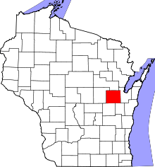 | |
| Villages | ||
| Towns | ||
| CDP | ||
| Unincorporated communities | ||
| Indian reservation | ||
| Ghost towns | ||
| Footnotes | ‡This populated place also has portions in an adjacent county or counties | |