Jamaica Beach, Texas
| City of Jamaica Beach | ||
|---|---|---|
| City | ||
|
Jamaica Beach City Hall | ||
| ||
| Motto: "A Great Place to Visit, but an even Better Place to Live" | ||
 Location of Jamaica Beach, Texas | ||
| Coordinates: 29°11′31″N 94°58′50″W / 29.19194°N 94.98056°WCoordinates: 29°11′31″N 94°58′50″W / 29.19194°N 94.98056°W | ||
| Country | United States | |
| State | Texas | |
| County | Galveston | |
| Government | ||
| • Type | General law | |
| • Mayor | Victor Pierson | |
| Area | ||
| • Total | 0.8 sq mi (2.0 km2) | |
| • Land | 0.6 sq mi (1.5 km2) | |
| • Water | 0.2 sq mi (0.5 km2) | |
| Elevation | 3 ft (1 m) | |
| Population (2010) | ||
| • Total | 983 | |
| • Density | 1,300/sq mi (490/km2) | |
| Time zone | Central (CST) (UTC-6) | |
| • Summer (DST) | CDT (UTC-5) | |
| ZIP codes | 77550, 77554 | |
| Area code(s) | 409 | |
| FIPS code | 48-37252[1] | |
| GNIS feature ID | 1388565[2] | |
| Website | http://www.ci.jamaicabeach.tx.us/ | |


Jamaica Beach is a city in Galveston County, Texas, United States on Galveston Island. As of the 2010 census, the city population was 983.[3]
History
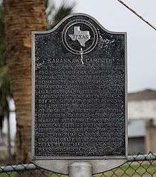
Prior to its development, Jamaica Beach was a burial ground of the Karankawa people. Johnny Goyen and Earl Galceran of the Jamaica Corporation developed Jamaica Beach as a 2,000-lot resort subdivision in close proximity to a marina.[4] The individuals who were a part of the development effort were Goyen, Galceran, brothers Jack and Welcome Wilson, Bill Sherrill, and Jack Valenti. They acquired an area of 320 acres (130 ha) that was owned by the Moody family. An oil businessperson named R.E. "Bob" Smith decided not to be a partner in the development, but he purchased the Moody land and sold it to the developers. He did not ask for any down payments and he guaranteed a $250,000 bank loan. Initially the beachfront lots, each 90 feet (27 m), were sold for $3,500 apiece. The "second row" houses sold at a quick pace. As the subsequent rows of houses opened to sale, the sales figures decreased slowly because while wealthy people were easily able to acquire second houses, middle class homebuyers were unable to get a mortgage, and needed to pay for the homebuilding with cash.[5]
In the 1960s, the discovery of a skull and the discovery that it was connected to a Karankawa Native American burial ground led to an increase in public exposure and visitors. Welcome Wilson said that no additional sales were generated by the publicity. With the growth of the second house market, almost all of the lots on Jamaica Beach had been sold by the 1970s. Due to a decline in the United States economy, the developer closed its doors.[5] The city incorporated on May 12, 1975. By 1978, 141 residents lived in Jamaica Beach. By 1988 the city had 446 residents and no businesses. By 1990 the city had 624 residents.[4]
In August 1983 Jamaica Beach was affected by Hurricane Alicia. In September 2008 Jamaica Beach was affected by Hurricane Ike.[6]
On Saturday August 9, 2008, Jamaica Beach celebrated the 50th anniversary of its groundbreaking. At the ceremony, Welcome Wilson donated boxes of news articles, brochures, and promotional materials in order to build a collection for a museum located at the city hall. In addition, the five children of Welcome Wilson donated $10,000 to the new museum.[5]
Geography
Jamaica Beach is located at 29°11′31″N 94°58′50″W / 29.19194°N 94.98056°W (29.192080, -94.980488).[7]
According to the United States Census Bureau, the city has a total area of 0.77 square miles (2.0 km2), of which, 0.58 square miles (1.5 km2) is land and 0.19 square miles (0.5 km2), or 24.57%, is water.[8]
The city has several pirate-themed street names. They include "Blackbeard," "Buccaneer," "Captain Hook," "Captain Kidd." "Francis Drake," "John Davis," "Jean Lafitte," "Mansvelt," "Henry Morgan," "John Silver," and "Edward Teach".[9]
Parks
Demographics
| Historical population | |||
|---|---|---|---|
| Census | Pop. | %± | |
| 1980 | 365 | — | |
| 1990 | 624 | 71.0% | |
| 2000 | 1,075 | 72.3% | |
| 2010 | 983 | −8.6% | |
| Est. 2015 | 1,047 | [10] | 6.5% |

2000 Census data
As of the census[1] of 2000, there were 1,075 people, 483 households, and 303 families residing in the city. The population density was 1,487.7 people per square mile (576.5/km²). There were 1,078 housing units at an average density of 1,491.8 per square mile (578.1/km²). The racial makeup of the city was 95.07% White, 0.37% African American, 0.37% Native American, 0.56% Asian, 1.95% from other races, and 1.67% from two or more races. Hispanic or Latino of any race were 8.56% of the population.
There were 483 households out of which 25.7% had children under the age of 18 living with them, 52.8% were married couples living together, 6.8% had a female householder with no husband present, and 37.1% were non-families. 27.3% of all households were made up of individuals and 7.7% had someone living alone who was 65 years of age or older. The average household size was 2.23 and the average family size was 2.74.
In the city the population was 20.3% under the age of 18, 4.9% from 18 to 24, 31.9% from 25 to 44, 28.4% from 45 to 64, and 14.5% who were 65 years of age or older. The median age was 42 years. For every 100 females there were 99.8 males. For every 100 females age 18 and over, there were 99.8 males. The median income for a household in the city was $52,045, and the median income for a family was $66,250. Males had a median income of $42,411 versus $31,875 for females. The per capita income for the city was $30,943. About 5.7% of families and 7.3% of the population were below the poverty line, including 8.4% of those under age 18 and none of those age 65 or over.
Government and infrastructure

As of 2008 the City Council includes Mayor Victor Pierson, Mayor Pro Tem Steve Spicer, and four aldermen (Brad South, Eddie Burke, Sherwood Green, and Mary Morse).[12] The city council established the Jamaica Beach Police Department in 1978; as of 2008 the department has one chief, one lieutenant, and five police officers. Jamaica Beach contracted its dispatching to the City of Hitchcock. After a large brush fire, the city created the Jamaica Beach Volunteer Fire Department and EMS in 1976. The city also has a municipal court, a water and sewer department, and a building department.[13]
In November 2007 a United States Postal Service Contract Postal Unit opened inside a local business in Jamaica Beach.[14] The West Galveston Contract Unit (77554-9998) is at Bob Smith Drive near Farm to Market Road 3005.
Education
Primary and secondary schools
Public schools
Pupils in Jamaica beach are zoned to schools in Galveston Independent School District. Students are zoned to Oppe Elementary School (K-4), Weis Middle School (5-6), Central Middle School (7-8), and Ball High School (9-12), all of which are in Galveston.
Colleges and universities
Galveston College serves Jamaica Beach.
References
- 1 2 "American FactFinder". United States Census Bureau. Retrieved 2008-01-31.
- ↑ "US Board on Geographic Names". United States Geological Survey. 2007-10-25. Retrieved 2008-01-31.
- ↑ "Profile of General Population and Housing Characteristics: 2010 Demographic Profile Data (DP-1): Jamaica Beach city, Texas". U.S. Census Bureau, American Factfinder. Retrieved January 6, 2012.
- 1 2 Jamaica Beach, Texas from the Handbook of Texas Online
- 1 2 3 Elder, Laura. "Wilson put out West End's Welcome mat." The Galveston Daily News. Sunday August 10, 2008. Vol. 166, No. 118. A1 and A7. Retrieved on January 15, 2012.
- ↑ Langford, Terri and Dale Lezon. "Jamaica Beach residents allowed to inspect homes." Houston Chronicle. September 20, 2008. Retrieved on January 16, 2012.
- ↑ "US Gazetteer files: 2010, 2000, and 1990". United States Census Bureau. 2011-02-12. Retrieved 2011-04-23.
- ↑ "Geographic Identifiers: 2010 Demographic Profile Data (G001): Jamaica Beach city, Texas". U.S. Census Bureau, American Factfinder. Retrieved January 6, 2012.
- ↑ "A pirate's life for me/Houston's quirkiest street names." (click the picture of the pirate) Houston Chronicle. Retrieved on February 12, 2015.
- ↑ "Annual Estimates of the Resident Population for Incorporated Places: April 1, 2010 to July 1, 2015". Retrieved July 2, 2016.
- ↑ "Census of Population and Housing". Census.gov. Retrieved June 4, 2015.
- ↑ "City Council Information." City of Jamaica Beach. Accessed September 15, 2008.
- ↑ "Departments." City of Jamaica Beach. Accessed September 15, 2008.
- ↑ The Galveston County Daily News
External links
| Wikivoyage has a travel guide for Jamaica Beach. |
| Counties | 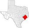 | |
|---|---|---|
| "Principal" cities | ||
| Other cities |
For a complete listing, see list of cities and towns in Houston–The Woodlands–Sugar Land MSA | |
| Unincorporated areas | ||
| Bodies of water | ||
Municipalities and communities of Galveston County, Texas, United States | ||
|---|---|---|
| Cities |  | |
| Village | ||
| CDPs | ||
| Unincorporated communities | ||
| Footnotes | ‡This populated place also has portions in an adjacent county or counties | |
