Pasadena, Texas
| Pasadena, Texas | |
|---|---|
| City | |
 | |
| Motto: "Enriched by our Heritage. Inspired by our Future." | |
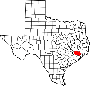
 Location in Harris County in the state of Texas | |
| Coordinates: 29°40′34″N 95°10′26″W / 29.67611°N 95.17389°WCoordinates: 29°40′34″N 95°10′26″W / 29.67611°N 95.17389°W | |
| Country |
|
| State |
|
| County | Harris |
| Founded | 1893 |
| Incorporated | December 22, 1923 and December 26, 1928 |
| Government | |
| • Type | Mayor-Council |
| • Mayor | Johnny Isbell |
| • City Council |
Ornaldo Ybarra Jackie Welch Don Harrison Pat Van Houte Erv Brannon Phil Cayten Steve Cote Darrell Morrison |
| Area | |
| • City | 44.5 sq mi (115.3 km2) |
| • Land | 44.2 sq mi (114.4 km2) |
| • Water | 0.4 sq mi (0.9 km2) |
| Elevation | 30 ft (9.1 m) |
| Population (2010) | |
| • City | 149,043 |
| • Density | 3,208/sq mi (1,238.7/km2) |
| • Metro | 5,628,101 |
| Time zone | CST (UTC-6) |
| • Summer (DST) | CDT (UTC-5) |
| ZIP codes | 77501-77506 |
| Area code(s) | Area codes 281, 346, 713, and 832 |
| FIPS code | 48-56000[1] |
| GNIS feature ID | 1343631[2] |
| Website | ci.pasadena.tx.us |
Pasadena /ˌpæsəˈdiːnə/ is a city in the U.S. state of Texas, within the Houston–The Woodlands–Sugar Land metropolitan area. As of the 2010 U.S. Census, the city's population is 149,043,[3] making it the seventeenth most populous city in the state of Texas, as well as the second-largest city in Harris County. The area was founded in 1893 by John H. Burnett of Galveston, who named the area after Pasadena, California, because of the perceived lush vegetation.[4]
The Pasadena Volunteer Fire Department is the largest all volunteer municipal fire department in the United States.[5][6]
History
Early history
Prior to European settlement the area around Galveston Bay was settled by the Karankawa and Atakapan tribes, particularly the Akokisa, who lived throughout the Gulf coast region. Spanish explorers such as the Rivas-Iriarte expedition and José Antonio de Evia charted the bay and gave it its name.[7] The pirate Jean Lafitte established a short-lived kingdom based in Galveston in the early 19th century with bases and hide-outs around the bay and around Clear Lake.[8] Lafitte was forced to leave in 1821 by the U.S. Navy.[9]
Following its declaration of independence from Spain the new nation of Mexico moved to colonize its northern territory of Texas by offering land grants to settlers both from within Mexico and from the nearby United States. The colony established by Stephen F. Austin and the Galveston Bay and Texas Land Company of New York rapidly began a wave of settlement around the bay.[10][11][12] Following a coup in the Mexican government by General Antonio Lopez de Santa Anna, Texas revolted against Mexican rule in 1835.[13] After several battles and skirmishes the final battle of the Texas Revolution took place near modern Pasadena on April 21, 1836. Santa Anna was captured at Vince's Bayou. Because this was the last conflict that led to the Mexican surrender, Pasadena and neighboring Deer Park have adopted the nickname "Birthplace of Texas".[14]
Ranching and settlement
Sam Allen started a ranch in 1843 with 350 acres (1.4 km2). This became the Allen Ranch which occupied what is now western Pasadena all the way to Harrisburg, Texas. By 1888, the ranch contained 15,000 acres (61 km2) in Harris County, 10,000 acres (40 km2) in Brazoria County, Texas with grazing lands in Galveston and Fort Bend Counties.
The Galveston, Harrisburg & Houston Railroad ran through the Allen ranch. There was a problem of cattle being regularly killed on the tracks and in 1875, Allen built a 19-mile (31 km) fence along the east side of the railway right of way to keep the cattle off the tracks. The fence ran from Harrisburg to League City and had four rails and a top rail wide enough to walk on. A gate was placed in the fence at the Harrisburg-Lynchburg Road with a large sign above instructing that it should be closed at all times. The area east of this railroad fence running from Buffalo Bayou to the tracks on Sims Bayou ran all the way to Galveston Bay. It contained 100,000 acres (400 km2) of grazing land for cattle.
"Proposed" towns in or near present-day Pasadena were set up but short lived and either abandoned or never even got off the ground. In 1892 Colonel John H. Burnett of Galveston established an unnamed townsite on the Vince Survey just east of the Allen Ranch. Burnett was involved in both construction and promotion of railroads and knew their impact on the value of property. The land was sold in 10 acres (4.0 ha) lots. He had also established the nearby towns of Deepwater and Genoa, later to be incorporated into Pasadena and Houston.
20th century

The 1900 hurricane that destroyed Galveston heavily damaged Pasadena, as well. The city received a population boost from some Galveston refugees who relocated to the mainland following the catastrophe.[15][16] Donations by the newly created Red Cross, including millions of strawberry plants to Gulf Coast farmers, helped revive the community.[17] This and the subsequent establishment of a major strawberry farm in the area by Texaco founder Joseph S. Cullinan made Pasadena a major fruit producer for many years afterward.[18] As the community recovered major tracts of the Allen Ranch were liquidated opening up new development.[19] Rice farmers from Japan settled in the community further diversifying its agriculture. Champion Coated Paper Company of Ohio opened a paper mill in 1937.[17][20] Other businesses began to develop.
In 1901 the Texas Oil Boom began with the gusher at Spindletop. The discovery of the oil field at Goose Creek led to increasing petroleum exploration around Galveston Bay.[21] By 1920 refinery operations had appeared in Pasadena and continued to expand thereafter.[17] The world wars gradually brought further industrial development, with Pasadena's growth rate surpassing even neighboring Houston.[16]
Pasadena voted to incorporate in 1923, but residents decided to cancel the incorporation one year later. Pasadena incorporated in 1928. Because of the 1928 incorporation, Houston did not incorporate Pasadena's territory into its city limits, while Houston annexed surrounding areas that were unincorporated.[4]
By the mid-20th century Pasadena's economy had become strongly tied to petroleum and other heavy industry. NASA's Johnson Space Center (JSC) was established near Pasadena in 1963 with the residential community of Clear Lake City, partially under Pasadena's jurisdiction, established nearby.[22] These developments helped to diversify the town's economy significantly.[17]
Former Pasadena City Council member and State Representative Ray Barnhart described the city at the time as "a lovely community but politically corrupt."[23] Barnhart recalled that a half dozen Pasadena officials were indicted in the late 1950s and early 1960s for public corruption.[23]
In 1965, Houston Post reporter Gene Goltz Received the Pulitzer Prize[24] for his exposure of government corruption in Pasadena, Texas, which resulted in widespread reforms.[24]
21st century
In the 21st century, Pasadena emerged as a mostly working-class suburb of Houston, with a 60 percent Hispanic population. Pasadena is preparing in 2015 to alter the composition of its city council. The city has eight council seats in single-member-district format. The new plan will divert two of the district seats to at-large representation. Councilman Ornaldo Ybarra said the change will reduce the impact of Hispanics on city elections. The mayor and other council members, however, claim that the change, now allowed under re-interpretation of the Voting Rights Act of 1965, will encourage greater voter turnout and promote interest in the city as a whole, rather than in specific districts.[25]
2015 Tornado
On October 30, 2015, an EF2 tornado struck a warehouse in Pasadena.[26] The warehouse was completely leveled with its roof completely mangled up. The tornado also damaged at least 30 houses throughout the city without any injuries.[27]
Geography

According to the United States Census Bureau, the city has a total area of 44.5 square miles (115 km2), of which 44.2 square miles (114 km2) is land and 0.4 square miles (1.0 km2) (0.81%) is water. The city is bordered by the Houston Ship Channel (Buffalo Bayou / San Jacinto River) to the north. The southeastern most part of the city fronts Galveston Bay.
Climate
The climate in this area is characterized by hot, humid summers and generally mild to cool winters.
Neighborhoods
Neighborhoods in Pasadena include:
- Vista Villas
- Allendale
- Bayport
- Baywood Oaks
- Baywood Shadows
- Burke Meadows
- Burkeshire
- Clear Lake City (Pasadena)
- Country Meadows
- Deepwater
- El Jardin del Mar
- Golden Acres
- Old Downtown
- Parkview Manor
- Parkview South
- Pasadena River Oaks
- Red Bluff Terrace
- Turtle Creek
- Village Grove East
- Village Grove East Townhomes
- Village Grove
Demographics
| Historical population | |||
|---|---|---|---|
| Census | Pop. | %± | |
| 1930 | 1,647 | — | |
| 1940 | 3,436 | 108.6% | |
| 1950 | 22,483 | 554.3% | |
| 1960 | 58,737 | 161.3% | |
| 1970 | 89,957 | 53.2% | |
| 1980 | 112,560 | 25.1% | |
| 1990 | 119,363 | 6.0% | |
| 2000 | 141,674 | 18.7% | |
| 2010 | 149,043 | 5.2% | |
| Est. 2015 | 153,784 | [28] | 3.2% |
| U.S. Decennial Census | |||
As of the census[1] of 2000, there were 141,674 people, 47,031 occupied housing units,[29] and 35,179 families residing in the city. The population density was 3,208.1 people per square mile (1,238.7/km²). There were 50,367 housing units[29] at an average density of 1,140.5 per square mile (440.4/km²).
The racial makeup of the city was 71.4% White, 1.6% African American, 0.7% American Indian and Alaska Native, 1.8% Asian, 0.0% Native Hawaiian and other Pacific Islander, 21.3% from other races, and 3.1% from two or more races. Hispanic or Latino of any race were 48.2% of the population.[29]
There were 47,031 households out of which 43.1% had children under the age of 18 living with them, 55.8% were married couples living together, 13.1% had a female householder with no husband present, and 25.2% were non-families. 20.4% of all households were made up of individuals and 6.2% had someone living alone who was 65 years of age or older. The average household size was 2.99 and the average family size was 3.48.
In the city the population was distributed by age as follows: 31.6% under the age of 18, 11.4% from 18 to 24, 31.2% from 25 to 44, 17.9% from 45 to 64, and 7.9% who were 65 years of age or older. The median age was 29 years. For every 100 females there were 99.8 males. For every 100 females age 18 and over, there were 97.6 males.
Economy
The city's key economic sectors include exploration for petroleum and gas, petroleum refining, petrochemical processing, solar panel manufacturing, maritime shipping, aerospace, and healthcare. The city's economy is closely linked to the nearby Houston Ship Channel and the Bayport shipping terminal and industrial district, as well as the National Aeronautics and Space Administration (NASA)'s Lyndon B. Johnson Space Center in the bordering Clear Lake Area.[30] The Pasadena Refining System, a partnership of Petrobras and Astra Holding USA, is headquartered in Pasadena.[31]
The nearby Bayport Industrial District, one of the nation's largest chemical processing complexes, is vital to employment in Pasadena.[32] High-tech businesses in the area related to the JSC have developed as well, and the opening of the Bayport shipping terminal is rapidly adding to the municipal economic base.[17]
Personal income
The median income for a household in the city was $38,522, and the median income for a family was $42,541. Males had a median income of $34,330 versus $25,869 for females. The per capita income for the city was $16,301. About 13.2% of families and 16.0% of the population were below the poverty line, including 20.8% of those under age 18 and 10.5% of those age 65 or over.
Other governmental
Harris County operates the Kyle Chapman/Pasadena Courthouse Annex.[33] Harris County Hospital District operates the Strawberry Health Center in Pasadena.[34]
The Texas Department of Criminal Justice (TDCJ) operates the Houston V District Parole Office in Pasadena.[35]
There are four post offices in the city limits.[36][37][38][39] In July 2011 the USPS announced that one, John Foster Post Office, may close.[40]
Top employers
According to the City's 2012 Comprehensive Annual Financial Report,[41] the top employers in the city are:
| # | Employer | # of Employees |
|---|---|---|
| 1 | Pasadena Independent School District | 5,800 |
| 2 | Dorsett Brothers Concrete Supply, Inc. | 3,400 |
| 3 | San Jacinto College District | 2,924 |
| 4 | The Boeing Company | 2,300 |
| 5 | Mundy Company | 1,500 |
| 6 | Zachry Holdings, Inc. | 1,400 |
| 7 | Shell - Deer Park | 1,400 |
| 7 | SGS Petroleum Service Corporation | 1,127 |
| 9 | Silver Eagle Distributors, L.P. | 1,100 |
| 10 | City of Pasadena | 1,030 |
Government
The Government of Pasadena operates under a Mayor-Council form of government with a mayor and eight council members who are responsible for enacting legislation, adopting budgets and setting policies.[42]
Police
The city has its own police department, which employs approximately 260 Officers, with 1 Police Chief, 3 Assistant Chiefs and other supervisory positions.
Elections
The last election was a special election held on January 19, 2008.
Mayor
- John Manlove July 2001–October 2007
- Jack Douglass October 2007–January 2008
- Johnny Isbell January 2008–present
Culture
The city has several museums, including the Pasadena Historical Museum,[43] the Bay Area Museum[44] and Armand Bayou Nature Center. Pasadena also has a community theater,[45] an annual rodeo,[46] and the Pasadena Philharmonic. The city's newspaper is the Pasadena Citizen.[47]
The Champion paper mill closed in 2005.[20] Because of the odor from the plant, Pasadena had been dubbed by locals with the nickname "Stinkadena." Several country music songs have been recorded with "Pasa-get-down-dena" as the title including Kenefick on their album "Hard Road."
Gilley's and Urban Cowboy
John Travolta, Debra Winger and other actors came to the city to film the 1980 hit movie Urban Cowboy, which depicted life and young love in Pasadena. The film centered on the city's honky-tonk bar Gilley's, which was co-owned by country music star Mickey Gilley. In 1989, Gilley's suffered an arson fire that gutted the interior of the building, including the mechanical bull used in Urban Cowboy. The shell of the building stood until 2006, when it was demolished by the Pasadena Independent School District, its current owner. Only the old sound recording studio remains. Gilley still resides in Pasadena. The old address of Gilley's is a used-car lot.[25]
Strawberry Festival

Clara Barton of the American Red Cross purchased 1.5 million strawberry plants and sent them to Pasadena to help victims of the flood get back on their feet. By the 1930s those crops had flourished so much that Pasadena was claiming the title of Strawberry Capital of the World. At its height, the city's strawberry growers shipped as many as 28 train carloads of strawberries each day. To honor that history, the city still holds an annual Pasadena Strawberry Festival. Strawberry Road stretches through much of the city near where the old strawberry crops grew.[48] Attendance at the annual Strawberry Festival was 56,000 in 2008.
Pasadena Philharmonic Society and Orchestra
Pasadena Philharmonic Society and Orchestra[49] is a combination of two groups. The Society is composed of members of the local community that support the fine arts and classical music. The Orchestra is composed of local music educators, musicians, college students and selected high school students. The Orchestra presented its first performance in the fall of 1982. The Philharmonic has presented performances ever since.
Education
Colleges and universities

Institutions of higher education include:
- University of Houston–Clear Lake
- San Jacinto College (Central Campus and System Headquarters) a community college system which serves all of Pasadena as well as all and portions of several other school districts.
- Texas Chiropractic College - Founded in 1908, Texas Chiropractic College is the fourth oldest chiropractic college in the nation. TCC is accredited as a Level V doctoral degree granting institution by the Southern Association of Colleges and Schools. TCC has maintained continuous accreditation since 1971. Its first-of-its-kind Hospital Rotations Program is a pioneer in the integrated health care field. The program provides interns the opportunity to rotate in nearly 30 hospitals and clinics throughout the Houston metropolitan area, including the Texas Medical Center.
Primary and secondary schools
Most of city of Pasadena is served by the Pasadena Independent School District. Some of the eastern part is served by Deer Park Independent School District, some of the southern part is served by Clear Creek Independent School District and La Porte Independent School District.
Public libraries
Pasadena owns the Pasadena Public Library with the Main Library at 1201 Jeff Ginn Memorial Drive and the Fairmont Library, a branch, at 4330 Fairmont Parkway between Panama Street and Watters Road.[50][51]
Parks and recreation
The city[52] operates 15 tennis courts, several baseball fields, and a total of 43 parks total.[53] These include over 14 miles (23 km) of trails,[54] four Youth Recreation Centers,[55] an Adaptive Recreation center,[56] three pools for Swimming or Aquatics,[57] an Athletics department,[58] a Dog Park,[59] Party Rentals,[60] a Golf Course,[61] an Historical Museum,[62] and a Senior Citizen Center.[63]
Harris County operates several community centers in Pasadena.[64]
- East Harris County Activity Center[65]
- Bay Area Community Center[66]
- Clear Lake Water Front (Pasadena Section)
Local residents have access to tennis courts, soccer fields, jogging tracks, walking tracks, picnic tables, family gathering pavilions at Pasadena's 47 parks, 5 swimming pools, and 5 game room buildings, museum, recreation center, 15 tennis courts and 21 ball fields.[67]
Armand Bayou Nature Center
Armand Bayou Nature Center (ABNC) is a 2,500 acres (1,000 ha) preserve on the western shore of Galveston Bay in Pasadena. It is the only remnant of this region's original eco-systems: coastal tallgrass prairie, bottomland forest and bayou. A diversity of plant life has taken root here, including bottomland hardwoods. Hundreds of species of wildlife thrive in the narrow wooded streams and scattered lakes, ponds and marshes. Armand Bayou also is a breeding and nursery ground for many finfish and shellfish and a haven for rarely seen species such as bobcats and owls.
As of 2010 ABNC has been designated as one of five preserves under the Texas Coastal Preserve Program of the Texas Parks and Wildlife Department.[68]
Infrastructure
Transportation
Pasadena is served by three freeway systems. Interstate 45 is the closest interstate to the Pasadena city limits. The main freeway artery is the Pasadena Freeway (State Highway 225). The east side of the Sam Houston Tollway (Beltway 8) runs through the eastern portion of the city.
The Harris County Toll Road Authority sells EZ Tags in the city.[69]
Public transportation
Metropolitan Transit Authority of Harris County, Texas (METRO) operates a park & ride service from the Pasadena Town Square Mall. This joint venture between Harris County, the city of Pasadena and METRO extended select trips. METRO operates four trips during the morning and five trips during the afternoon rush hours.[70] Harris County Transit operates a bus route that runs through most of the city, stopping at health centers, shopping centers, colleges, and other venues, with connections to neighboring cites.[71] The Pasadena Park and Ride lot is located on the north side of Pasadena Town Square.[72]
County services
Harris County Youth Village, a juvenile detention facility, is located in far southern Pasadena,[73] but it has a Seabrook postal address.[74]
Notable people
- Ray Barnhart, former member of the Texas House of Representatives from Pasadena, later director of the Federal Highway Administration
- Marlen Esparza, Olympic competitor 2012 and bronze medalist in women's boxing
- Dean Corll, serial killer, rapist, kidnapper and torturer, died in Pasadena
- Jacob Green, All American football player
- Russell Harvard, actor, There Will Be Blood, Fargo
- Gilbert Pena, 2015 Republican member of the Texas House of Representatives from Pasadena
- Robert Talton, member of the Texas House of Representatives from District 144 in Pasadena, 1993-2009; candidate for Chief Justice of the Texas Supreme Court in 2014 Republican primary election[75]
- Mickey Gilley, world-famous country singer and part owner of Gilley's night club, used for filming of Urban Cowboy.
Sister cities
Pasadena has formalized sister city agreements with the following cities:[76]
See also
References
- 1 2 "American FactFinder". United States Census Bureau. Retrieved 2008-01-31.
- ↑ "US Board on Geographic Names". United States Geological Survey. 2007-10-25. Retrieved 2008-01-31.
- ↑ Bay Area Houston Economic Partnership
- 1 2 Lee, Renée C. "Annexed Kingwood split on effects." Houston Chronicle. Sunday October 8, 2006. A21. Retrieved on July 6, 2011. "Some of the area communities that incorporated as cities and escaped annexation by Houston:" Print version exclusively has the information cited; the information is not included in the online edition.
- ↑ Robin L. Phillips. "Firefighters: Tough Job Requires Tougher Volunteers". Regional VuePoint Magazine. Retrieved 2009-09-12.
- ↑ "About Us". Pasadena Volunteer Fire Department. Retrieved 2009-09-12.
- ↑ Morris, John Miller: Exploration from the Handbook of Texas Online. Retrieved 14 Nov 2009. Texas State Historical Association.
Kleiner, Diana J.: Galveston County from the Handbook of Texas Online. Retrieved 14 Nov 2009. Texas State Historical Association. - ↑
- Chang, Yushan (2006). Newcomer's Handbook Neighborhood Guide: Dallas-Fort Worth, Houston, and Austin. Portland, OR: First Books. pp. 180–192 [187]. ISBN 0-912301-70-8.
Kearney, Syd (2005). A Marmac Guide to Houston and Galveston. Gretna, LA: Pelican Publishing Company. p. 177. ISBN 1-58980-322-1.
- Chang, Yushan (2006). Newcomer's Handbook Neighborhood Guide: Dallas-Fort Worth, Houston, and Austin. Portland, OR: First Books. pp. 180–192 [187]. ISBN 0-912301-70-8.
- ↑ Warren, Harris Gaylord: Lafitte, Jean from the Handbook of Texas Online. Retrieved 7 Nov 2009. Texas State Historical Association.
- ↑ Barker, Eugene C.: Austin, Stephen Fuller from the Handbook of Texas Online. Retrieved 14 Nov 2009. Texas State Historical Association.
- ↑ Reichstein, Andreas: Galveston Bay and Texas Land Company from the Handbook of Texas Online. Retrieved 15 Nov 2009. Texas State Historical Association.
- ↑ Barker (1969), pp. 277–278.
- ↑ Barker, Eugene C.; Pohl, James W.: Texas Revolution from the Handbook of Texas Online. Retrieved 15 Nov 2009. Texas State Historical Association.
- ↑ Washington County, Texas shares the claim to that title, since that is where the Texas Declaration of Independence was signed. Brazoria County, Texas claims to be "Where Texas Began", as its city of Velasco, Texas was where the Treaties of Velasco were signed, and where Stephen F. Austin originally settled."Brazoria County Home". Brazoria County, Texas. Retrieved 2009-06-12.
- ↑ "Pasadena Texas – History". Global Oneness. Retrieved 12 Sep 2009.
The Galveston Hurricane of 1900 caused many people to resettle in Pasadena.
- 1 2 "Our City: The Birthplace of Free Texas". City of Pasadena. Retrieved 12 Sep 2009.
- 1 2 3 4 5 Pomeroy, C. David, Jr.: Pasadena, Texas from the Handbook of Texas Online. Retrieved 29 Oct 2009. Texas State Historical Association
- ↑ Gallaway, Alecya (July 2003). "Armand Bayou Watershed History". Armand Bayou Watershed Partnership.
The earliest information about farming in the watershed actually originated on the land of Anson Taylor who was at Taylor Lake and Taylor Bayou. Taylor was an associate of Jean Lafitte and sold his produce, firewood, and meat from wild game and cattle to Lafitte's camp town, Campechy, on Galveston Island.
- ↑ Pomeroy, C. David, Jr.: Allen Ranch from the Handbook of Texas Online. Retrieved 16 Oct 2009. Texas State Historical Association.
- 1 2
- ↑ Henson (1993), p. 46.
- ↑ Greene, Casey Edward: Clear Lake City, Texas from the Handbook of Texas Online. Retrieved 27 Oct 2009. Texas State Historical Association
- 1 2 Statement of Ray Barnhart, January 7, 2010
- 1 2
- ↑ http://abc13.com/news/building-collapses-amid-storms-in-pasadena/1061324/
- ↑ http://www.spc.noaa.gov/climo/reports/151030_rpts.html
- ↑ "Annual Estimates of the Resident Population for Incorporated Places: April 1, 2010 to July 1, 2015". Retrieved July 2, 2016.
- 1 2 3 "Pasadena, Texas - Fact Sheet - American FactFinder. Census 2000 Demographic Profile Highlights:". US Census Bureau. Retrieved 2011-05-16.
- ↑ "Economic development". City of Pasadena, Texas. Retrieved 31 Jan 2010.
- ↑ "Contact Us." Pasadena Refining System. Retrieved on August 9, 2010.
- ↑ "Chemicals & Plastics". Bay Area Houston Economic Partnership. Retrieved 4 Sep 2009.
edited by Bruce W. Radford. (1983). Public utilities fortnightly. 112. Public Utilities Reports, inc. p. 61. ISBN 0-910325-28-6.The Big Three complex at Bayport is one of the nation's largest industrial gas plants and the only one in the country which is steam-powered.
- ↑ "Courthouse Annexes." Harris County Precinct 2. Retrieved on May 23, 2010.
- ↑ "Strawberry Health Center." Harris County Hospital District. Retrieved on December 6, 2008.
- ↑ "Parole Division Region III." Texas Department of Criminal Justice. Retrieved on May 15, 2010.
- ↑ "Post Office Location - PASADENA." United States Postal Service. Retrieved on December 6, 2008.
- ↑ "Post Office Location - JOHN FOSTER." United States Postal Service. Retrieved on December 6, 2008.
- ↑ "Post Office Location - BOB HARRIS." United States Postal Service. Retrieved on December 6, 2008.
- ↑ "Post Office Location - DEBERT L. ATKINSON." United States Postal Service. Retrieved on December 6, 2008.
- ↑ Weisman, Laura. "Nine Houston post offices marked for closure (with poll)." Houston Chronicle. July 26, 2011. Retrieved on July 26, 2011.
- ↑ City of Pasadena, Texas Comprehensive Annual Financial Report - for the fiscal year ended September 30, 2012.
- ↑ http://www.ci.pasadena.tx.us/cityhall.htm
- ↑ Pasadena Historical Museum
- ↑ "Bay Area Museum". Lunar Rendezvous Festival. Retrieved 4 December 2013.
- ↑ Pasadena Little Theatre
- ↑ Pasadena Livestock Show & Rodeo
- ↑ Pasadena Citizen Online
- ↑ Pasadena Strawberry Festival
- ↑ Pasadena Philharmonic Society and Orchestra
- ↑ "Hours & Location." Pasadena Public Library. Retrieved on December 6, 2008.
- ↑ "Fairmont Library." Pasadena Public Library. Retrieved on December 6, 2008.
- ↑ The Pasadena Parks and Recreation Department
- ↑ White, Stanley. "Special Projects Coordinator". The City of Pasadena Texas. Stanley White. Retrieved 11 February 2013.
- ↑ Parks and Trails
- ↑ Youth Recreation Centers
- ↑ Adaptive Recreation
- ↑ Swimming/Aquatics
- ↑ Athletics
- ↑ Dog Park
- ↑ Party Rentals
- ↑ Golf Course
- ↑ Historical Museum
- ↑ Senior Citizen Center
- ↑
- ↑ East Harris County Activity Center
- ↑ Bay Area Community Center
- ↑
- ↑ Hegen, Ed. "Protection of Fragile Coastal Ecosystems: Texas Coastal Preserves". Texas Parks and Wildlife Department. Retrieved 20 Jan 2010.
- ↑ "EZ TAG Stores." Harris County Toll Road Authority. Retrieved on May 16, 2010.
- ↑
- ↑ "Routes / Maps." Harris County Transit. Retrieved on January 15, 2010.
- ↑ "Park & Ride." Harris County Transit. Retrieved on May 28, 2010.
- ↑ "New District Map" (Archive). City of Pasadnea. Retrieved on November 8, 2015.
- ↑ "Residential Facilities." Harris County Juvenile Probation Department. Retrieved on November 8, 2015. "Harris County Youth Village 210 J.W. Mills Drive, Seabrook"
- ↑ "Robert Talton". taltonforchiefjustice.com. Retrieved February 8, 2014.
- ↑ "Texas' International Sister Cities by Area and Country". Texas Sister Cities International. Retrieved 13 Jan 2010.
External links
- City of Pasadena
- Pasadena Texas Community Information
- Pasadena Chamber of Commerce
- Pasadena Citizen
- Pasadena Strawberry Festival
- Pasadena Livestock Show & Rodeo
- Pasadena Information
- Pasadena, Texas from the Handbook of Texas Online
| Large cities | 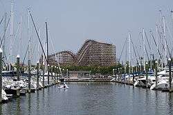 | |
|---|---|---|
| Other cities | ||
| CDPs and non- municipalities | ||
| Counties | ||
| Subregions | ||
| Bodies of water | ||
| Major ports | ||
| Nature preserves | ||
| Counties | 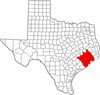 | |
|---|---|---|
| "Principal" cities | ||
| Other cities |
For a complete listing, see list of cities and towns in Houston–The Woodlands–Sugar Land MSA | |
| Unincorporated areas | ||
| Bodies of water | ||

| ||
| ||