Interstate 84 in Oregon
| ||||
|---|---|---|---|---|
 | ||||
| Route information | ||||
| Maintained by ODOT | ||||
| Length: | 375.68 mi[1] (604.60 km) | |||
| Existed: | 1957 – present | |||
| Major junctions | ||||
| West end: |
| |||
|
| ||||
| East end: |
| |||
| Highway system | ||||
| ||||
.svg.png)
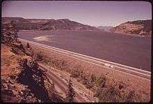
Interstate 84 (I-84) in the U.S. state of Oregon, also known as the Vietnam Veterans Memorial Highway,[2] travels east–west, following the Columbia River and the rough path of the old Oregon Trail from Portland east to Idaho. For this reason, it is also known as most of the Columbia River Highway No. 2 and all of the Old Oregon Trail Highway No. 6 (see Oregon highways and routes). It also follows along or near U.S. Route 30. The entire highway carried the designation Interstate 80N (I-80N, or Interstate 80 North) until 1980, when this was changed to I-84.[3]
Route description

Interstate 84 begins in Portland, Oregon where it connects with Interstate 5 on the east side of the Willamette River. It continues east, crossing Interstate 205, before curving to the north to join the Columbia River. It continues along the river, passing Interstate 82 in Hermiston, and U.S. Route 395 in Pendleton. It then curves to the south, until it gets to the Idaho border. It continues into Idaho.
The Cabbage Hill grade east of Pendleton is a 6% grade, with several hairpin curves in both directions and a separation between directions of almost 2 miles (3 km).

Banfield Expressway
The T.H. Banfield Expressway is the portion of Interstate 84 between its western terminus at Interstate 5 and its intersection at Interstate 205 in Portland, Oregon, United States. The expressway, originally built as part of US 30, is named for Thomas H. "Harry" Banfield (1885–1950), a former Oregon State Highway commissioner.
Prior to the creation of the Banfield, surface streets were the only routes from Portland to the country. Under President Dwight D. Eisenhower, the federal government had started providing federal assistance to expressway projects. As a result, planners designed a freeway system in Portland. The first step in building this new freeway system was to construct the Banfield, which would stretch from Portland to Troutdale. On October 1, 1955, the Banfield Expressway opened to traffic. It was Oregon's first freeway.[4] The highway was rebuilt during the 1980s, and the MAX Light Rail line was added along the north side at the same time.

History
Improvements to the Columbia River Highway and Old Oregon Trail Highway had been planned since the 1930s, but World War II delayed those plans. The Oregon State Highway Division started implementing these improvements segment by segment beginning in the 1950s as bond funding became available. One of the segments completed in the early 1950s was the Banfield Expressway in Portland.
When the Federal Interstate and Defense Highways Act was passed in 1956, U.S. Route 30 was scheduled to be superseded by Interstate 80N, on an alignment closer to the river on flat terrain. The segment between Portland and The Dalles was mostly complete by 1963, but it would take until 1968 for construction of the highway to meet Interstate highway standards. The highway was designated Interstate 80N until May 1980, when it was changed to Interstate 84 to eliminate confusion with the western section of the non-suffixed I-80, which split from I-80N in Salt Lake City and continued west to San Francisco as I-80.[3] Construction on the remaining segments continued until January 3, 1975, when the segment of Interstate 84 from Portland to the Idaho border was completed to Interstate standards. Oregon In 2016 ODOT has installed a variable speed zone on a 30-mile stretch of Interstate 84 between Baker City, Or and Ladd Canyon. The new electronic signs collect data regarding temperature, skid resistance, and average motorist speed to determine the most effective speed limit for the area before presenting the limit on the sign. This speed zone is scheduled to be activated November 2016.[5]
Exit list
| County | Location[6] | mi[6] | km | Exit | Destinations | Notes |
|---|---|---|---|---|---|---|
| Multnomah | Portland | 0.00 | 0.00 | — | OMSI, City Center | Exit 300 on I-5 north |
Convention Center, Moda Center | Western end of concurrency with US 30; Exit 301 on I-5 south | |||||
| 0.66 | 1.06 | — | Eastbound entrance only | |||
| 1.10 | 1.77 | 1 | Lloyd Center | Westbound signage; westbound exit and eastbound entrance | ||
| 2.16 | 3.48 | 1 | 33rd Avenue | Eastbound signage; eastbound exit and westbound entrance | ||
| 2.55 | 4.10 | 2 | César E. Chávez Boulevard | Eastbound signage | ||
| 2.93 | 4.72 | 43rd Avenue | Westbound signage | |||
| 3.48 | 5.60 | 3 | 58th Avenue | No westbound exit | ||
| 4.11 | 6.61 | 4 | 68th Avenue | Eastbound exit only | ||
| 5.01 | 8.06 | 5 | Eastbound exit and westbound entrance | |||
| 5.41 | 8.71 | 6 | Eastbound exit and westbound entrance; Exit 21B on I-205 | |||
| 5.69 | 9.16 | 7 | Halsey Street | Eastbound exit only | ||
| 6.29 | 10.12 | 8 | Eastbound exit only | |||
| 6.55 | 10.54 | 9 | 102nd Avenue | Eastbound signage; eastbound exit and westbound entrance | ||
| 7.13 | 11.47 | 9 | Westbound signage; westbound left exit and eastbound left entrance; Exit 22 on I-205 | |||
| 7.75 | 12.47 | 10 | 122nd Avenue | Eastbound exit and entrance | ||
| Gresham | 10.71 | 17.24 | 13 | 181st Avenue / Airport Way – Gresham | Gresham only appears on eastbound signage; Airport Way only appears on westbound signage | |
| Fairview | 12.08 | 19.44 | 14 | Fairview Parkway (207th Avenue) | ||
| Wood Village | 13.63 | 21.94 | 16 | 238th Drive – Wood Village | ||
| Troutdale | 14.33– 15.18 | 23.06– 24.43 | 17 | Marine Drive / 257th Avenue | ||
| | 15.49 | 24.93 | 18 | Lewis and Clark State Park, Oxbow Regional Park | ||
| | 19.77 | 31.82 | 22 | Corbett | ||
| | 22.66 | 36.47 | 25 | Rooster Rock State Park | ||
| | 25.53 | 41.09 | 28 | Historic Columbia River Highway – Bridal Veil | Eastbound exit and westbound entrance | |
| | 27.08 | 43.58 | 29 | Dalton Point | Westbound exit and entrance | |
| | 28.22 | 45.42 | 30 | Benson State Recreation Area | Eastbound exit and entrance | |
| | 28.84– 29.15 | 46.41– 46.91 | 31 | Multnomah Falls | Left exit and entrance | |
| | 32.90– 33.19 | 52.95– 53.41 | 35 | Historic Columbia River Highway – Ainsworth State Park | ||
| | 35.26 | 56.75 | 37 | Warrendale | Westbound exit and eastbound entrance | |
| | 37.94 | 61.06 | 40 | Bonneville Dam National Historic Landmark | ||
| | 39.10 | 62.93 | 41 | Eagle Creek National Fish Hatchery, Eagle Creek Recreation Area | Eastbound exit and entrance | |
| Hood River | Cascade Locks | 41.31 | 66.48 | 44 | Eastern end of concurrency with US 30; eastbound exit and westbound entrance | |
| 42.72 | 68.75 | 44 | Western end of concurrency with US 30; westbound exit and eastbound entrance | |||
| | 45.22 | 72.77 | 47 | Forest Lane – Herman Creek | Westbound exit and eastbound entrance | |
| Wyeth | 48.66 | 78.31 | 51 | Wyeth | ||
| | 52.44 | 84.39 | 55 | Starvation Creek Trailhead, Historic Columbia River Highway State Trail | Eastbound exit and entrance; no trucks | |
| | 53.71 | 86.44 | 56 | Viento State Park | ||
| | 56.02 | 90.16 | 58 | Mitchell Point Overlook | Eastbound exit and entrance | |
| | 57.63 | 92.75 | — | Service Road | Westbound exit and eastbound entrance; access to Mitchell Point Drive | |
| | 58.40 | 93.99 | — | (unsigned) | Westbound exit and entrance; access to Morton Road | |
| Hood River | 59.73 | 96.13 | 62 | US 30 only appears on eastbound signage; eastern end of concurrency with US 30 | ||
| 61.59 | 99.12 | 63 | Hood River City Center | |||
| 62.11 | 99.96 | 64 | US 30 only appears on westbound signage; western end of concurrency with US 30 | |||
| | 63.35 | 101.95 | — | Koberg Beach State Recreation Site | Westbound exit and entrance | |
| Wasco | Mosier | 67.46 | 108.57 | 69 | US 30 only appears on eastbound signage; eastern end of concurrency with US 30 | |
| | 74.32 | 119.61 | 76 | Rowena | ||
| The Dalles | 79.74 | 128.33 | 82 | Columbia Gorge Discovery Center, Wasco County Museum | ||
| 81.34 | 130.90 | 83 | West The Dalles (US 30) | Signed as Exit 84 westbound | ||
| 81.63 | 131.37 | 84 | The Dalles City Center (US 30 east) | Eastbound exit only | ||
| 83.18 | 133.87 | 85 | The Dalles City Center, National Historic Districts | |||
| 84.68 | 136.28 | 87 | US 30 only appears on westbound signage; western end of concurrency with US 30 | |||
| | 86.50 | 139.21 | 88 | The Dalles Dam | ||
| | 94.81 | 152.58 | 97 | |||
| Sherman | | 102.23 | 164.52 | 104 | ||
| Rufus | 107.62 | 173.20 | 109 | Rufus, John Day Dam | ||
| | 109.67– 110.10 | 176.50– 177.19 | 112 | (no name) | ||
| | 111.90 | 180.09 | 114 | LePage Park, John Day River | ||
| Sherman–Gilliam county line | | 112.26 | 180.66 | John Day River | ||
| Gilliam | Quinton | 120.98 | 194.70 | 123 | Philippi Canyon | |
| | 127.10 | 204.55 | 129 | Blalock Canyon | ||
| | 128.70 | 207.12 | 131 | Woelpern Road | Eastbound exit and westbound entrance | |
| Arlington | 135.26– 136.24 | 217.68– 219.26 | 137 | |||
| Heppner Junction | 145.02 | 233.39 | 147 | |||
| Morrow | | 149.42 | 240.47 | 151 | Threemile Canyon | |
| | 156.97 | 252.62 | 159 | Tower Road | ||
| Boardman | 161.83 | 260.44 | 164 | Boardman | ||
| 163.43 | 263.02 | 165 | Port of Morrow | |||
| | 165.62 | 266.54 | 168 | |||
| | 168.80 | 271.66 | 171 | Paterson Ferry Road | ||
| Umatilla | | 175.65 | 282.68 | 177 | Umatilla Army Depot | |
| | 176.69– 177.54 | 284.35– 285.72 | 179 | Hermiston only appears on eastbound signage; Kennewick only appears on westbound signage | ||
| | 178.08 | 286.59 | 180 | Westland Road – Hermiston | Hermiston only appears on eastbound signage | |
| Bucks Corner | 180.53 | 290.53 | 182 | |||
| | 186.51 | 300.16 | 188 | Echo only appears on eastbound signage; Hermiston only appears on westbound signage; western end of concurrency with US 395 | ||
| | 191.20 | 307.71 | 193 | Echo Road – Lexington | Lexington only appears on westbound signage | |
| | 196.21 | 315.77 | 198 | Lorenzen Road / McClintock Road | ||
| | 197.20 | 317.36 | 199 | Yoakum Road – Stage Gulch | Stage Gulch only appears on eastbound signage | |
| | 200.58 | 322.80 | 202 | Barnhart Road / Airport Road | ||
| Pendleton | 205.14 | 330.14 | 207 | US 30 only appears on eastbound signage; eastern end of concurrency with US 30 | ||
| 207.21 | 333.47 | 209 | Eastern end of concurrency with US 395 | |||
| 208.63 | 335.76 | 210 | OR 11 and Milton-Freewater only appear on eastbound signage | |||
| | 210.99 | 339.56 | 213 | Western end of concurrency with US 30; westbound exit and eastbound entrance | ||
| | 213.72 | 343.95 | 216 | |||
| | 222.34 | 357.82 | 224 | Poverty Flat Road / Old Emigrant Hill Road | ||
| | 226.61 | 364.69 | 228 | Deadman Pass | Rest area | |
| | 226.86 | 365.10 | Deadman Pass summit, elevation 3,615 feet (1,102 m) | |||
| | 231.48– 232.35 | 372.53– 373.93 | 234 | Emigrant Springs State Park | ||
| | 236.44 | 380.51 | 238 | Meacham, Kamela | Kamela only appears on eastbound signage | |
| | 239.02 | 384.67 | Blue Mountain summit, elevation 4,193 feet (1,278 m) | |||
| | 241.19 | 388.16 | 243 | Summit Road – Mt. Emily | ||
| Union | | 246.61 | 396.88 | 248 | Spring Creek Road – Kamela | Kamela only appears on westbound signage |
| | 250.52 | 403.17 | 252 | |||
| | 253.92 | 408.64 | 256 | Perry | Eastbound exit and westbound entrance | |
| 254.53 | 409.63 | 257 | Perry | Westbound exit and eastbound entrance | ||
| | 256.86 | 413.38 | 259 | Eastern end of concurrency with US 30; eastbound exit and westbound entrance | ||
| La Grande | 259.51 | 417.64 | 261 | |||
| | 262.59 | 422.60 | 265 | US 30 only appears on westbound signage; western end of concurrency with US 30 | ||
| | 265.93 | 427.97 | 268 | Foothill Road | ||
| | 268.51 | 432.12 | 270 | Ladd Creek Road | Eastbound exit and westbound entrance | |
| | 271.58 | 437.07 | 273 | Frontage Road | ||
| | 276.31 | 444.68 | 278 | Clover Creek | ||
| | 281.31 | 452.72 | 283 | Wolf Creek Lane | ||
| North Powder | 283.35 | 456.01 | 285 | US 30 only appears on eastbound signage; eastern end of concurrency with US 30 | ||
| Baker | | 296.35 | 476.93 | 298 | Medical Springs only appears on eastbound signage; Haines only appears on westbound signage | |
| | 300.38 | 483.41 | 302 | North Baker City only appears on eastbound signage; Hells Canyon only appears on westbound signage | ||
| Baker City | 301.81 | 485.72 | 304 | |||
| | 304.20 | 489.56 | 306 | Haines only appears on westbound signage; western end of concurrency with US 30 | ||
| | 311.31 | 501.00 | 313 | Pleasant Valley | Eastbound exit and westbound entrance | |
| | 315.14 | 507.17 | 317 | Pleasant Valley | Westbound exit and eastbound entrance | |
| | 325.10 | 523.20 | 327 | Durkee | ||
| Nelson Point | 328.34 | 528.41 | 330 | Cement Plant Road / Plano Road | ||
| | 333.43 | 536.60 | 335 | Weatherby | ||
| | 335.78 | 540.39 | 338 | Lookout Mountain | ||
| | 338.09 | 544.10 | 340 | Rye Valley | ||
| | 340.57 | 548.09 | 342 | Lime | Eastbound exit and westbound entrance | |
| | 343.50 | 552.81 | 345 | Eastbound signage | ||
| Lime | Westbound signage | |||||
| Malheur | | 350.71 | 564.41 | 353 | Farewell Bend State Park | Eastbound signage |
| Westbound signage | ||||||
| | 353.84 | 569.45 | 356 | |||
| | 359.82 | 579.07 | 362 | Moores Hollow Road | ||
| | 369.12 | 594.04 | 371 | Stanton Boulevard | ||
| Ontario | 372.20 | 599.00 | 374 | Ontario only appears on eastbound signage; Weiser only appears on westbound signage | ||
| 374.39 | 602.52 | 376A | TVCC only appears on eastbound sigange | |||
| 376B | Eastern end of concurrency with US 30 | |||||
| | 375.68 | 604.60 | — | Continuation into Idaho | ||
1.000 mi = 1.609 km; 1.000 km = 0.621 mi
| ||||||
References
- ↑ Oregon Department of Transportation, Public Road Inventory, accessed October 2007
- ↑ "Oregion SB 461: http://gov.oregonlive.com/bill/2013/SB461/"
- 1 2 "I-80N becomes I-84 May 1". (April 1, 1980). The Oregonian, p. B4.
- ↑ Trevinson, Catherine; Franzen, Robin (2005-08-11). "Banfield offers entry to new era". The Oregonian.
- ↑ http://www.oregon.gov/ODOT/COMM/docs/Oregon_Interstate_Background.pdf?ga=t, pp. 6-7
- 1 2 Road Inventory and Classification Services Unit. "Straightline Charts". Transportation Development Division, Oregon Department of Transportation. Retrieved September 22, 2016.
- Columbia River Highway No. 2 (August 2012)
- Old Oregon Trail Highway No. 6 (February 2012)
External links
| Wikimedia Commons has media related to Interstate 84 (west). |
- Oregon Interstate Background, Oregon Department of Transportation
| Previous state: Terminus |
Oregon | Next state: Idaho |