Corbett, Oregon
This article is about the community on the Columbia River. For the area in Portland, see South Portland, Portland, Oregon.
| Corbett | |
|---|---|
| Unincorporated community | |
|
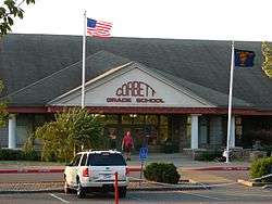
The flags at Corbett Grade School demonstrate Corbett's signature east wind. | |
 Corbett  Corbett Location within the state of Oregon | |
| Coordinates: 45°31′55″N 122°17′24″W / 45.53194°N 122.29000°WCoordinates: 45°31′55″N 122°17′24″W / 45.53194°N 122.29000°W | |
| Country | United States |
| State | Oregon |
| County | Multnomah |
| Time zone | Pacific (PST) (UTC-8) |
| • Summer (DST) | PDT (UTC-7) |
| ZIP codes | 97019 |
Corbett is an unincorporated community on the Columbia River in eastern Multnomah County, Oregon, United States. It is located on the Historic Columbia River Highway (aka Crown Point Highway) between the Sandy River and Crown Point.
Corbett was named for prominent pioneer Senator Henry W. Corbett.[1] Senator Corbett purchased a farm in the area in 1885. After several name changes, the post office in the area was named "Corbett" in 1895. Corbett's ZIP Code is 97019.
Corbett School District runs the Corbett School and the Corbett Charter School.
Notable people
- Julius Meier, politician
- Billy Oskay, musician
- Patti Smith, politician
- Fritz Springmeier, author
- Dave Stief, football player
References
- ↑ McArthur, Lewis A.; McArthur, Lewis L. (2003) [1928]. Oregon Geographic Names (7th ed.). Portland, Oregon: Oregon Historical Society Press. ISBN 978-0875952772.
External links
![]() Media related to Corbett, Oregon at Wikimedia Commons
Media related to Corbett, Oregon at Wikimedia Commons
Municipalities and communities of Multnomah County, Oregon, United States | ||
|---|---|---|
| Cities |  | |
| Unincorporated communities | ||
| Footnotes | ‡This populated place also has portions in an adjacent county or counties | |
This article is issued from Wikipedia - version of the 11/12/2016. The text is available under the Creative Commons Attribution/Share Alike but additional terms may apply for the media files.