Adair County, Iowa
| Adair County, Iowa | |
|---|---|
 | |
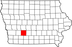 Location in the U.S. state of Iowa | |
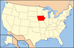 Iowa's location in the U.S. | |
| Founded | 1851 |
| Named for | John Adair |
| Seat | Greenfield |
| Largest city | Greenfield |
| Area | |
| • Total | 570 sq mi (1,476 km2) |
| • Land | 569 sq mi (1,474 km2) |
| • Water | 1.0 sq mi (3 km2), 0.2% |
| Population | |
| • (2010) | 7,682 |
| • Density | 13/sq mi (5/km²) |
| Congressional district | 3rd |
| Time zone | Central: UTC-6/-5 |
| Website |
www |
Adair County is a county located in the U.S. state of Iowa. As of the 2010 census, the population was 7,682.[1] Its county seat is Greenfield.[2]
The county used to be part of Iowa's 5th congressional district, which had a score of R+9 (strongly Republican) in the Cook Partisan Voting Index.[3]
History
Adair County was formed in 1851 from sections of Pottawattamie County. It was named for John Adair, a general in the War of 1812, and the eighth Governor of Kentucky.
Geography
According to the U.S. Census Bureau, the county has a total area of 570 square miles (1,500 km2), of which 569 square miles (1,470 km2) is land and 1.0 square mile (2.6 km2) (0.2%) is water.[4]
Major highways
.svg.png) Interstate 80
Interstate 80.svg.png) U.S. Highway 6
U.S. Highway 6 Iowa Highway 25
 Iowa Highway 92
 Iowa Highway 925
Adjacent counties
- Guthrie County (north)
- Madison County (east)
- Union County (southeast)
- Adams County (southwest)
- Cass County (west)
Demographics
| Historical population | |||
|---|---|---|---|
| Census | Pop. | %± | |
| 1860 | 984 | — | |
| 1870 | 3,982 | 304.7% | |
| 1880 | 11,667 | 193.0% | |
| 1890 | 14,534 | 24.6% | |
| 1900 | 16,192 | 11.4% | |
| 1910 | 14,420 | −10.9% | |
| 1920 | 14,259 | −1.1% | |
| 1930 | 13,891 | −2.6% | |
| 1940 | 13,196 | −5.0% | |
| 1950 | 12,292 | −6.9% | |
| 1960 | 10,893 | −11.4% | |
| 1970 | 9,487 | −12.9% | |
| 1980 | 9,509 | 0.2% | |
| 1990 | 8,409 | −11.6% | |
| 2000 | 8,243 | −2.0% | |
| 2010 | 7,682 | −6.8% | |
| Est. 2015 | 7,228 | [5] | −5.9% |
| U.S. Decennial Census[6] 1790-1960[7] 1900-1990[8] 1990-2000[9] 2010-2013[1] | |||
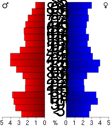
As of the 2010 United States Census, there were 7,682 people, 3,292 households, and 2,148 families residing in the county.[10] The population density was 13.5 inhabitants per square mile (5.2/km2). There were 3,698 housing units at an average density of 6.5 per square mile (2.5/km2).[11] The racial makeup of the county was 98.4% white, 0.3% Asian, 0.1% American Indian, 0.1% black or African American, 0.4% from other races, and 0.7% from two or more races. Those of Hispanic or Latino origin made up 1.3% of the population.[10] In terms of ancestry, 42.9% were German, 12.6% were Irish, 11.9% were English, 6.7% were Danish, and 6.4% were American.[12]
Of the 3,292 households, 26.8% had children under the age of 18 living with them, 54.9% were married couples living together, 6.7% had a female householder with no husband present, 34.8% were non-families, and 30.7% of all households were made up of individuals. The average household size was 2.29 and the average family size was 2.84. The median age was 45.3 years.[10]
The median income for a household in the county was $45,202 and the median income for a family was $57,287. Males had a median income of $38,638 versus $31,642 for females. The per capita income for the county was $23,497. About 5.7% of families and 10.6% of the population were below the poverty line, including 13.5% of those under age 18 and 11.4% of those age 65 or over.[13]
Religion
As of 2000, 67.9% of the population (5,597) had a declared religious affiliation, in every case Christian. The leading religious denomination was the United Methodist Church, with 23.6% of the population (1,944 members); second was the Lutheran Church-Missouri Synod, with 15.4% (1,268 members); third was the Roman Catholic church, with 12% of the population (1,003 members); and fourth was the Evangelical Lutheran church, with 11.8% of the population (978 members).[14]
Education
The county is served by five school districts:[15]
- Nodaway Valley Community School District
- Orient-Macksburg Community School District.
- Cumberland-Anita-Massena Community School District
- Adair-Casey Community School District
- West Central Valley Community School District
The schools in the Nodaway Valley Community School District are:[16]
The schools in the Orient-Macksburg Community School District are:[17]
Communities
Cities
Townships
Adair County is divided into seventeen townships:
Population ranking
The population ranking of the following table is based on the 2010 census of Adair County.[18]
† county seat
| Rank | City/Town/etc. | Municipal type | Population (2010 Census)
|
|---|---|---|---|
| 1 | † Greenfield | City | 1,982 |
| 2 | Stuart (partially in Guthrie County) | City | 1,648 |
| 3 | Adair (partially in Guthrie County) | City | 781 |
| 4 | Fontanelle | City | 672 |
| 5 | Casey (partially in Guthrie County) | City | 426 |
| 6 | Orient | City | 408 |
| 7 | Bridgewater | City | 182 |
See also
References
- 1 2 "State & County QuickFacts". United States Census Bureau. Retrieved July 13, 2014.
- ↑ "Find a County". National Association of Counties. Archived from the original on 2011-05-31. Retrieved 2011-06-07.
- ↑ The Cook Political Report (2009). "Partisan Voting Index: Districts of the 111th Congress" (PDF). The Cook Political Report. Retrieved 2011-11-10.
- ↑ "US Gazetteer files: 2010, 2000, and 1990". United States Census Bureau. 2011-02-12. Retrieved 2011-04-23.
- ↑ "County Totals Dataset: Population, Population Change and Estimated Components of Population Change: April 1, 2010 to July 1, 2015". Retrieved July 2, 2016.
- ↑ "U.S. Decennial Census". United States Census Bureau. Archived from the original on May 11, 2015. Retrieved July 13, 2014.
- ↑ "Historical Census Browser". University of Virginia Library. Retrieved July 13, 2014.
- ↑ "Population of Counties by Decennial Census: 1900 to 1990". United States Census Bureau. Retrieved July 13, 2014.
- ↑ "Census 2000 PHC-T-4. Ranking Tables for Counties: 1990 and 2000" (PDF). United States Census Bureau. Retrieved July 13, 2014.
- 1 2 3 "DP-1 Profile of General Population and Housing Characteristics: 2010 Demographic Profile Data". United States Census Bureau. Retrieved 2015-07-13.
- ↑ "Population, Housing Units, Area, and Density: 2010 - County". United States Census Bureau. Retrieved 2015-07-13.
- ↑ "DP02 SELECTED SOCIAL CHARACTERISTICS IN THE UNITED STATES – 2006-2010 American Community Survey 5-Year Estimates". United States Census Bureau. Retrieved 2015-07-13.
- ↑ "DP03 SELECTED ECONOMIC CHARACTERISTICS – 2006-2010 American Community Survey 5-Year Estimates". United States Census Bureau. Retrieved 2015-07-13.
- ↑ "Religious Congregations & Membership: 2000". Glenmary Research Center. Archived from the original (jpg) on 2006-12-14. Retrieved 2009-04-24.
- ↑ Education, Iowa Department of (2009). "Iowa Educational Directory" (PDF). Iowa Department of Education. Archived from the original on 19 December 2009. Retrieved 2009-12-19.
- ↑ Nodaway Valley Community School District (2014-01-09). "Nodaway Valley CSD". Nodaway Valley Community School District. Retrieved 2014-01-09.
- ↑ Orient-Macksburg Community Schools (2009-11-18). "Orient-Macksburg CSD". Orient-Macksburg Community Schools. Retrieved 2009-12-19.
- ↑ http://www.census.gov/2010census/
External links
| Wikimedia Commons has media related to Adair County, Iowa. |
 |
Guthrie County | | ||
| Cass County | |
Madison County | ||
| ||||
| | ||||
| Adams County | Union County |
Municipalities and communities of Adair County, Iowa, United States | ||
|---|---|---|
| Cities | ||
| Townships | ||
| Unincorporated communities | ||
| Footnotes | ‡This populated place also has portions in an adjacent county or counties | |
Coordinates: 41°19′50″N 94°28′16″W / 41.33056°N 94.47111°W