Davis County, Iowa
| Davis County, Iowa | |
|---|---|
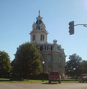 Davis County Courthouse | |
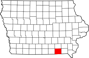 Location in the U.S. state of Iowa | |
 Iowa's location in the U.S. | |
| Founded | 1843 |
| Named for | Garrett Davis |
| Seat | Bloomfield |
| Largest city | Bloomfield |
| Area | |
| • Total | 505 sq mi (1,308 km2) |
| • Land | 502 sq mi (1,300 km2) |
| • Water | 2.7 sq mi (7 km2), 0.5% |
| Population | |
| • (2010) | 8,753 |
| • Density | 17/sq mi (7/km²) |
| Congressional district | 2nd |
| Time zone | Central: UTC-6/-5 |
| Website |
www |
Davis County is a county located in the U.S. state of Iowa. As of the 2010 census, the population was 8,753.[1] The county seat is Bloomfield.[2]
Davis County is included in the Ottumwa, IA Micropolitan Statistical Area.
History
Davis County was named in honor of Garrett Davis, a Congressman from Kentucky from March 4, 1839, till March 3, 1847, and later a US Senator from Kentucky.[3][4]
Geography
According to the U.S. Census Bureau, the county has a total area of 505 square miles (1,310 km2), of which 502 square miles (1,300 km2) is land and 2.7 square miles (7.0 km2) (0.5%) is water.[5]
Major highways
Adjacent counties
- Wapello County (north)
- Monroe County (northwest)
- Van Buren County (east)
- Jefferson County (northeast)
- Scotland County, Missouri (southeast)
- Schuyler County, Missouri (southwest)
- Appanoose County (west)
Demographics
| Historical population | |||
|---|---|---|---|
| Census | Pop. | %± | |
| 1850 | 7,264 | — | |
| 1860 | 13,764 | 89.5% | |
| 1870 | 15,565 | 13.1% | |
| 1880 | 16,468 | 5.8% | |
| 1890 | 15,258 | −7.3% | |
| 1900 | 15,620 | 2.4% | |
| 1910 | 13,315 | −14.8% | |
| 1920 | 12,574 | −5.6% | |
| 1930 | 11,150 | −11.3% | |
| 1940 | 11,136 | −0.1% | |
| 1950 | 9,959 | −10.6% | |
| 1960 | 9,199 | −7.6% | |
| 1970 | 8,207 | −10.8% | |
| 1980 | 9,104 | 10.9% | |
| 1990 | 8,312 | −8.7% | |
| 2000 | 8,541 | 2.8% | |
| 2010 | 8,753 | 2.5% | |
| Est. 2015 | 8,769 | [6] | 0.2% |
| U.S. Decennial Census[7] 1790-1960[8] 1900-1990[9] 1990-2000[10] 2010-2014[1] | |||
2010 census
The 2010 census recorded a population of 8,753 in the county, with a population density of 17.3947/sq mi (6.7161/km2). There were 3,600 housing units, of which 3,201 were occupied.[11]
2000 census
As of the census[12] of 2000, there were 8,541 people, 3,207 households, and 2,286 families residing in the county. The population density was 17 people per square mile (7/km²). There were 3,530 housing units at an average density of 7 per square mile (3/km²). The racial makeup of the county was 98.35% White, 0.18% Black or African American, 0.21% Native American, 0.20% Asian, 0.05% Pacific Islander, 0.21% from other races, and 0.81% from two or more races. 0.71% of the population were Hispanic or Latino of any race. 10.4% of the population speak either German or Pennsylvania German at home.[13]
There were 3,207 households out of which 32.00% had children under the age of 18 living with them, 62.70% were married couples living together, 5.20% had a female householder with no husband present, and 28.70% were non-families. 25.00% of all households were made up of individuals and 13.80% had someone living alone who was 65 years of age or older. The average household size was 2.61 and the average family size was 3.13.
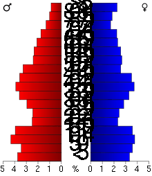
In the county the population was spread out with 27.10% under the age of 18, 7.40% from 18 to 24, 25.20% from 25 to 44, 22.90% from 45 to 64, and 17.40% who were 65 years of age or older. The median age was 38 years. For every 100 females there were 97.90 males. For every 100 females age 18 and over, there were 94.10 males.
The median income for a household in the county was $32,864, and the median income for a family was $40,982. Males had a median income of $26,818 versus $21,726 for females. The per capita income for the county was $15,127. About 9.00% of families and 11.90% of the population were below the poverty line, including 12.70% of those under age 18 and 12.80% of those age 65 or over.
Communities
Cities
Unincorporated community
Townships
Davis County is divided into these townships:
Population ranking
The population ranking of the following table is based on the 2010 census of Davis County.[14]
† county seat
| Rank | City/Town/etc. | Municipal type | Population (2010 Census)
|
|---|---|---|---|
| 1 | † Bloomfield | City | 2,640 |
| 2 | Pulaski | City | 260 |
| 3 | Drakesville | City | 184 |
| 4 | Floris | City | 138 |
Notable people
- John Pickler, member of the United States House of Representatives, resident of Davis County.[15]
See also
References
- 1 2 "State & County QuickFacts". United States Census Bureau. Retrieved July 16, 2014.
- ↑ "Find a County". National Association of Counties. Retrieved 2011-06-07.
- ↑ "Profile for Davis County, Iowa, IA". ePodunk. Retrieved October 4, 2012.
- ↑ Gannett, Henry (1905). The Origin of Certain Place Names in the United States. Govt. Print. Off. p. 101.
- ↑ "US Gazetteer files: 2010, 2000, and 1990". United States Census Bureau. 2011-02-12. Retrieved 2011-04-23.
- ↑ "County Totals Dataset: Population, Population Change and Estimated Components of Population Change: April 1, 2010 to July 1, 2015". Retrieved July 2, 2016.
- ↑ "U.S. Decennial Census". United States Census Bureau. Retrieved July 16, 2014.
- ↑ "Historical Census Browser". University of Virginia Library. Retrieved July 16, 2014.
- ↑ "Population of Counties by Decennial Census: 1900 to 1990". United States Census Bureau. Retrieved July 16, 2014.
- ↑ "Census 2000 PHC-T-4. Ranking Tables for Counties: 1990 and 2000" (PDF). United States Census Bureau. Retrieved July 16, 2014.
- ↑ "Population & Housing Occupancy Status 2010". United States Census Bureau American FactFinder. Retrieved May 7, 2011.
- ↑ "American FactFinder". United States Census Bureau. Retrieved 2008-01-31.
- ↑ "Find US, State, Region, or Division language statistics". MLA Language Map Data Center. Retrieved May 7, 2011.
- ↑ http://www.census.gov/2010census/
- ↑ "PICKLER, John Alfred, (1844 - 1910)". Biographical Directory of the United States Congress. Retrieved October 4, 2012.
External links
| Wikimedia Commons has media related to Davis County, Iowa. |
 |
Monroe County | Wapello County | Jefferson County | |
| Appanoose County | |
Van Buren County | ||
| ||||
| | ||||
| Schuyler County, Missouri | Scotland County, Missouri |
Municipalities and communities of Davis County, Iowa, United States | ||
|---|---|---|
| Cities | ||
| Townships | ||
| Unincorporated community | ||
Coordinates: 40°44′40″N 92°24′48″W / 40.74444°N 92.41333°W