Waterloo, Iowa
| Waterloo, Iowa | |
|---|---|
| City | |
|
from the West bank of the Cedar River. | |
 Location in the State of Iowa | |
 Waterloo, Iowa Location in the United States | |
| Coordinates: 42°29′33″N 92°20′46″W / 42.49250°N 92.34611°W | |
| Country | United States |
| State |
|
| County | Black Hawk |
| Incorporated | 1868 |
| Government | |
| • Mayor | Quentin Hart |
| Area[1] | |
| • City | 63.23 sq mi (163.76 km2) |
| • Land | 61.39 sq mi (159.00 km2) |
| • Water | 1.84 sq mi (4.77 km2) |
| Elevation | 883 ft (269 m) |
| Population (2010)[2] | |
| • City | 68,406 |
| • Estimate (2014[3]) | 68,364 |
| • Rank | 6th in Iowa |
| • Density | 1,113.6/sq mi (430.0/km2) |
| • Metro | 169,895 |
| Time zone | CST (UTC−6) |
| • Summer (DST) | CDT (UTC−5) |
| ZIP codes | 50701-50707 |
| Area code(s) | 319 |
| FIPS code | 19-82425 |
| GNIS feature ID | 468951 |
| Website | www.ci.waterloo.ia.us |

Waterloo is a city in and the county seat of Black Hawk County, Iowa, United States.[4] As of the 2010 United States Census the population decreased by 0.5% to 68,406;[5] a recent 2014 Census estimates the population at 68,364, making it the sixth-largest city in the state.[3] Waterloo is part of the Waterloo – Cedar Falls Metropolitan Statistical Area, and is the more populous of the two cities.
History
Waterloo was originally known as Prairie Rapids Crossing. The town was established, according to the original researcher as reported by staff of the Grout Museum in Waterloo, near two Meskwaki American tribal seasonal camps alongside the Cedar River. It was first settled in 1845 when George and Mary Melrose Hanna and their children arrived on the east bank of the Red Cedar River (now just called the Cedar River). They were followed by the Virden and Mullan families in 1846. Evidence of these earliest families can still be found in the street names Hanna Blvd., Mullan Avenue and Virden Creek.
On December 8, 1845 the Iowa State Register and Waterloo Herald was the first newspaper published in Waterloo.[6]
The name "Waterloo" supplanted the original name, "Prairie Rapids Crossing" shortly after Charles Mullan petitioned for a post office in the town. Since the signed petition did not include the name of the proposed post office location, Mullan was charged with selecting the name when he submitted the petition. Tradition has it that as he flipped through a list of other post offices in the United States, he came upon the name "Waterloo." The name struck his fancy, and on December 29, 1851, a post office was established under that name. The town was later called the same, and Mullan served as the first postmaster from December 29, 1851 until August 11, 1854.
There were two extended periods of rapid growth over the next 115 years. From 1895 to 1915, the population increased from 8,490 to 33,097, a 290% increase. From 1925 to 1960, population increased from 36,771 to 71,755. The 1895 to 1915 period was a time of the rapid growth in manufacturing, rail transportation and wholesale operations. During this period the Waterloo Gasoline Traction Engine Company moved to Waterloo and shortly after Rath Packing Company moved from Dubuque. Another major employer throughout the first two-thirds of the 20th century was the Illinois Central Railroad. Among the others was the less-successful brass era automobile manufacturer, the Maytag-Mason Motor Company.[7]
On June 7, 1934, bank robber Tommy Carroll had a shoot-out with the FBI when he and his wife stopped to pick up gas. Accidentally parking next to a police car and wasting time dropping his gun and picking it back up, Carroll was forced to flee into an alley where he was shot. Carroll was then taken to Allen Memorial Hospital in Waterloo, where he died shortly after.
Waterloo suffered particularly hard in the agricultural recession of the 1980s, due to the major employers at the time being heavily rooted in agriculture. In particular, John Deere, the area's largest employer, cut 10,000 jobs, and the Rath meatpacking plant closed altogether, losing 2500 jobs. It is estimated Waterloo lost 14% of its population during this time.[8] Today the city enjoys a broader industrial base, as city leaders have sought to diversify the industrial and commercial mix. Deere remains a strong presence in the city, but employs only roughly one-third the number of people it did at its peak.
African American Community
In 1910 a significant amount of black railroad workers were brought in as strikebreakers to the Waterloo area.[9][10] Black workers were regulated to 20 square blocks in Waterloo which remains the 'East' side to this day.[9][10] In 1940 more black strikebreakers were brought in to work in the Rath meat plant.[11] In 1948 a black strikebreaker accidentally killed a white union member as he tried to escape the strikers ire. Instead of a race riot a strike ensued against the Rath Company, necessitating the National Guard being called in to end the 73-day strike.[11]
Civil Rights
United Packinghouse Workers of America became the main union of the Rath Company, welcoming in black workers.[12] However United Auto Workers Local 838 continued to refuse black members[13] With the power of the union, Anna Mae Weems, Ada Treadwell, Charles Pearson and Jimmy Porter formed an anti discrimination department at Rath by the 1950s. This department helped organize protests against local places that discriminated against blacks.[9]
Porter would go on to organize the first black radio station in Waterloo KBBG in 1978.[10][12] Weems became the head of the anti discrimination department and local NAACP chapter.[9]
May 31, 1966 Eddie Wallace Sallis was found dead in the local jail. The black community felt the death was suspicious and protests were held. June 4, Weems led a march on city hall to encourage investigation into his death.[10][12] The march led to the creation of the Waterloo Human Rights Commission, which would only last a year due to lack of funding.[14]
On Sept. 7, 1967, a city report titled "Waterloo's Unfinished Business" was released.[15] The report covered the ongoing problems in housing, education and employment faced by the black community of Waterloo. The report confirmed the housing bias faced by black residents, that many of the schools were generally 80% of one race, and that 80% of black residents held service jobs.[15] In a 2007 article the Courier covered some change in the 40 years since. The article found housing was now mostly divided by socioeconomic status, schools still violated the desegregation plan and black unemployment was still double that of white residents.[15]
The Iowa Supreme Court had outlawed school segregation in 1868.[14] A 1967 commission found most schools were still segregated and recommended immediate desegregation, which Mayor Lloyd Turner opposed.[12] In 1969 the Waterloo school board voted to allow open enrollment in all their schools to encourage integration. Many parents felt it was not enough.[12] Despite the efforts between 1967 and 1970, already black schools in the area increased in their segregation.[12]
Protests and Riots
By the 1960s Rath was in decline and jobs there were harder to come by. A federal government program trained 1,200 local youths with the promise of summer jobs, only to hire two as bricklayers.[9] Starting in the summer months of 1966,[16] Waterloo was subject to riots over race relations between the white community and the black community. Many white residents expressed confusion as to why riots were occurring in Waterloo,[12][16] while younger black residents felt they were being treated unfairly, as their conditions seemed worse than their white neighbors.[16] In 1967 the black population of Waterloo was equivalent to 8%, and according to the Courier had a 4% unemployment rate.[16] Yet despite being a northern city, Waterloo was unofficially segregated at the time as 95% of its black population lived in 'East' Waterloo.[16] While the white community felt East High was 'integrated' with a 45% black student body, the black community pointed out the elementary school in 'East' Waterloo only had one white pupil.
Protests were mostly organized by black teenagers aged 16–25.[15][16] Protests would turn to riots when the youth felt protesting wasn't effective.[16] Protests turned into riots in July 1968[16] and reached 'critical' mass by that September with buildings on East 4th street torched and vandalized.[15]
In August 1968, East High students Terri and Kathy Pearson, presented the current principal with a list of grievances and how they felt the discrimination could be lessened. The principal refused to initiate any of the requested changes[12] Student protests and walk outs continued through September. Students were angry that no African American history course was being taught, and that interracial dating was being discouraged by teachers and administrators.[12]
Sep 13, 1968, during an East High School football team, the police attempted arrest a black youth.[10] The man resisted arrest, drawing attention of the students in the stands. Black students fought and argued with the police, to which police responded by using clubs and mace.[12] The riot continued into the East side of Waterloo, starting a fire that claimed a lumber mill and three homes. There was an attempt to set East High on fire as well.[12] The riot lasted into midnight and resulted in seven officers injured and thirteen youth jailed. The National Guard was called in for the following day.[12]
Present Day
In 2003 Governor Vilsack created a task force to try and close the racial achievement gap in Waterloo.[17] In 2009 a fair housing report titled "Analysis of Impediments to Fair Housing Choice" compiled by Mullin & Lonergan Associates Inc, found Waterloo to be the most segregated city in Iowa[13] "Historical patterns of racial segregation persist in Waterloo, of the 20 cities in Iowa with populations exceeding 25,000, Waterloo ranks as the most segregated."[13]
Many activists who partook in the original protests feel Waterloo has remained the same.[10][15] In 2015 Huffpost listed Waterloo as the 10th worst city for black Americans.[18] The site noted black residents have a 24% unemployment rate in the city compared with 3.9% for whites, giving Waterloo one of the highest black unemployment rates in the article compared to other Midwest cities.[10] Waterloo still has a higher percentage of blacks compared to most other cities in Iowa.[10]
December 2012 Derrick Ambrose Jr was shot by a police officer. Ambrose's family maintains he was unarmed while the cop stated he felt his life was in danger. A grand jury acquitted the cop. This shooting sparked outrage in the community.[10]
Flood of 2008
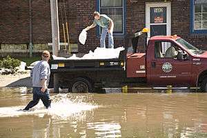
June 2008 saw the worst flooding in the Waterloo – Cedar Falls area had ever recorded; other major floods include the Great Flood of 1993. The flood control system constructed in the 1970s–90s largely functioned as designed.
For those areas not protected by the system, the Cedar River poured out of its banks and into parking lots, backyards and across the rich Iowa farmland surrounding the city. Although much damage was done, the larger, downstream city of Cedar Rapids was much harder hit.
An area of the west side of the down-town and an area near the former Rath Packing facility were impacted not directly by water coming from the river but were the result of storm run-off draining towards the river but then being trapped on the backside of the flood levy system. These areas did not have lift stations or alternate pumping capacity sufficient to force this water to the river side of the control system. Areas where lift stations had been constructed (Virden Creek and East 7th Street ) to pump this storm run-off into the swollen river remained largely dry (the east and north sides of down-town). Several areas experienced water seeping into basements due to high water-table levels.
- Historical Crests
According to the National Weather Service the ten highest crests of the Cedar River recorded at East 7th Street in downtown Waterloo:[19]
|
(1) 27.01 ft on June 11, 2008 |
(6) 20.54 ft on April 2, 1993 |
Crests reported in the 1960s and prior were before completion of major flood control projects and therefore may not be directly comparable.
In September 2016, flood watches and warnings were put in affect for the city of Waterloo and its surrounding cities. The crest is expected to just barely hit the height of the 2008 flood.
Geography

According to the United States Census Bureau, the city has a total area of 63.23 square miles (163.76 km2), of which, 61.39 square miles (159.00 km2) is land and 1.84 square miles (4.77 km2) is water.[1]
The average elevation of Waterloo is 846 feet above sea level. The population density is 1101 people per square mile, considered low for an urban area.[20]
Climate
Waterloo has a humid continental climate zone (Köppen classification Dfa),[21] typical of the state of Iowa, and is part of USDA Plant Hardiness zone 5a.[22] The normal monthly mean temperature ranges from 18.5 °F (−7.5 °C) in January to 73.6 °F (23.1 °C) in July. On average, there are 22 nights annually with a low at or below 0 °F (−18 °C), 58 days annually with a high at or below freezing, and 16 days with a high at or above 90 °F (32 °C). As the mean first and last occurrence of freezing temperatures is October 1 and April 29, respectively, this allows for a growing season of 154 days. Temperature records range from −34 °F (−37 °C) on March 1, 1962 and January 16, 2009 up to 112 °F (44 °C) on July 13 and 14, 1936, during the Dust Bowl. The record cold daily maximum is −16 °F (−27 °C) on February 2, 1996, while, conversely, the record warm daily minimum is 80 °F (27 °C) on July 31, 1917 and August 16, 1988.[23]
Normal annual precipitation equivalent is 34.60 inches (879 mm) spread over an average 112 days, with heavier rainfall in spring and summer, but observed annual rainfall has ranged from 17.35 to 53.07 inches (441 to 1,348 mm) in 1910 and 1993, respectively. The wettest month on record is July 1999 with 12.82 inches (326 mm); on the 2nd of that month, 5.49 inches (139 mm) of rain fell, making for the heaviest rainfall in a single calendar day. The driest months are October 1952 and November 1954 with trace amounts each.[23]
Winter snowfall is moderate, and averages 35.3 inches (90 cm) per season, spread over an average 27 days, and snow cover of 1 inch (2.5 cm) or more is seen on 67 days, mostly from December to March. Winter snowfall has ranged from 11.6 inches (29.5 cm) in 1967–68 to 68.5 inches (174.0 cm) in 1904–05. The most snow in a calendar day and month is 13.2 inches (33.5 cm) and 33.9 inches (86.1 cm) on January 3, 1971 and in December 2000, respectively.[23]
| Climate data for Waterloo Regional Airport, Iowa (1981–2010 normals,[24] extremes 1895–present) | |||||||||||||
|---|---|---|---|---|---|---|---|---|---|---|---|---|---|
| Month | Jan | Feb | Mar | Apr | May | Jun | Jul | Aug | Sep | Oct | Nov | Dec | Year |
| Record high °F (°C) | 65 (18) |
71 (22) |
87 (31) |
100 (38) |
108 (42) |
107 (42) |
112 (44) |
110 (43) |
102 (39) |
95 (35) |
83 (28) |
67 (19) |
112 (44) |
| Mean maximum °F (°C) | 46.9 (8.3) |
51.8 (11) |
71.7 (22.1) |
83.2 (28.4) |
88.0 (31.1) |
93.3 (34.1) |
94.9 (34.9) |
93.0 (33.9) |
89.8 (32.1) |
82.5 (28.1) |
66.5 (19.2) |
48.8 (9.3) |
96.6 (35.9) |
| Average high °F (°C) | 27.4 (−2.6) |
32.2 (0.1) |
45.6 (7.6) |
60.6 (15.9) |
72.0 (22.2) |
81.2 (27.3) |
84.4 (29.1) |
82.2 (27.9) |
75.3 (24.1) |
61.9 (16.6) |
45.9 (7.7) |
30.8 (−0.7) |
58.4 (14.7) |
| Average low °F (°C) | 9.5 (−12.5) |
14.6 (−9.7) |
26.0 (−3.3) |
37.2 (2.9) |
49.0 (9.4) |
58.9 (14.9) |
62.8 (17.1) |
60.2 (15.7) |
50.7 (10.4) |
38.7 (3.7) |
26.8 (−2.9) |
13.5 (−10.3) |
37.4 (3) |
| Mean minimum °F (°C) | −14.9 (−26.1) |
−10.7 (−23.7) |
4.9 (−15.1) |
19.6 (−6.9) |
33.4 (0.8) |
44.9 (7.2) |
50.7 (10.4) |
46.9 (8.3) |
32.9 (0.5) |
21.5 (−5.8) |
8.7 (−12.9) |
−10.4 (−23.6) |
−19.6 (−28.7) |
| Record low °F (°C) | −34 (−37) |
−31 (−35) |
−34 (−37) |
−4 (−20) |
22 (−6) |
33 (1) |
42 (6) |
33 (1) |
19 (−7) |
0 (−18) |
−17 (−27) |
−29 (−34) |
−34 (−37) |
| Average precipitation inches (mm) | 0.83 (21.1) |
0.99 (25.1) |
2.06 (52.3) |
3.71 (94.2) |
4.53 (115.1) |
4.98 (126.5) |
4.91 (124.7) |
4.27 (108.5) |
2.63 (66.8) |
2.48 (63) |
2.01 (51.1) |
1.20 (30.5) |
34.60 (878.8) |
| Average snowfall inches (cm) | 8.2 (20.8) |
7.4 (18.8) |
4.6 (11.7) |
1.8 (4.6) |
0 (0) |
0 (0) |
0 (0) |
0 (0) |
0 (0) |
0.3 (0.8) |
3.1 (7.9) |
9.9 (25.1) |
35.3 (89.7) |
| Average precipitation days (≥ 0.01 in) | 7.2 | 7.4 | 9.7 | 10.9 | 12.4 | 11.5 | 9.7 | 9.1 | 8.5 | 8.5 | 8.6 | 8.4 | 111.9 |
| Average snowy days (≥ 0.1 in) | 6.5 | 5.6 | 3.4 | 1.1 | 0 | 0 | 0 | 0 | 0 | 0.2 | 2.9 | 6.9 | 26.6 |
| Average relative humidity (%) | 73.0 | 73.8 | 72.7 | 66.4 | 65.7 | 67.7 | 71.9 | 73.7 | 73.7 | 69.9 | 74.8 | 77.2 | 71.8 |
| Source: NOAA (relative humidity 1961–90),[23][25][26] | |||||||||||||
Demographics
| Historical population | |||
|---|---|---|---|
| Census | Pop. | %± | |
| 1870 | 4,337 | — | |
| 1880 | 5,630 | 29.8% | |
| 1890 | 6,674 | 18.5% | |
| 1900 | 12,580 | 88.5% | |
| 1910 | 26,693 | 112.2% | |
| 1920 | 36,230 | 35.7% | |
| 1930 | 46,191 | 27.5% | |
| 1940 | 51,743 | 12.0% | |
| 1950 | 65,198 | 26.0% | |
| 1960 | 71,755 | 10.1% | |
| 1970 | 75,533 | 5.3% | |
| 1980 | 75,985 | 0.6% | |
| 1990 | 66,467 | −12.5% | |
| 2000 | 68,747 | 3.4% | |
| 2010 | 68,406 | −0.5% | |
| Est. 2015 | 68,460 | [27] | 0.1% |
2010 census
As of the census[2] of 2010, there were 68,406 people, 28,607 households, 17,233 families residing in the city. The population density was 1,114.3 inhabitants per square mile (430.2/km2). There were 30,723 housing units at an average density of 500.5 per square mile (193.2/km2). The racial makeup of the city was 77.3% White, 15.5% African American, 0.3% Native American, 1.1% Asian, 0.3% Pacific Islander, 2.6% from other races, and 3.0% from two or more races. Hispanic or Latino of any race were 5.6% of the population.
There were 28,607 households of which 29.9% had children under the age of 18 living with them, 40.3% were married couples living together, 14.9% had a female householder with no husband present, 5.1% had a male householder with no wife present, and 39.8% were non-families. 31.6% of all households were made up of individuals and 11.2% had someone living alone who was 65 years of age or older. The average household size was 2.35 and the average family size was 2.95.
The median age in the city was 35.9 years. 23.7% of residents were under the age of 18; 10.4% were between the ages of 18 and 24; 26.4% were from 25 to 44; 25.5% were from 45 to 64; and 14% were 65 years of age or older. The gender makeup of the city was 48.4% male and 51.6% female.
2000 census
As of the 2000 census,[28] there were 68,747 people, 28,169 households, and 17,746 families residing in the city. The population density was 1,131.9 inhabitants per square mile (437.0/km2). There were 29,499 housing units at an average density of 485.7 per square mile (187.5/km2). The racial makeup of the city was 79.2% White, 14.5% African American, 1.1% Asian, 1.9% from other races, and 2.0% from two or more races. Hispanic or Latino of any race were 3.2% of the population.
There were 28,169 households out of which 29.0% had children under the age of 18 living with them, 46.0% were married couples living together, 13.3% had a female householder with no husband present, and 37.0% were non-families. 30.0% of all households were made up of individuals and 12.1% had someone living alone who was 65 years of age or older. The average household size was 2.39 and the average family size was 2.97.
Age spread: 24.7% under the age of 18, 10.6% from 18 to 24, 27.5% from 25 to 44, 22.0% from 45 to 64, and 15.3% who were 65 years of age or older. The median age was 36 years. For every 100 females there were 92.2 males. For every 100 females age 18 and over, there were 88.0 males.[29]
The median income for a household in the city was $34,092, and the median income for a family was $42,731. Males had a median income of $31,491 versus $22,569 for females. The per capita income for the city was $18,558. About 10.0% of families and 13.7% of the population were below the poverty line, including 18.6% of those under age 18 and 10.5% of those age 65 or over.
Metropolitan area
The Waterloo-Cedar Falls Metropolitan Statistical Area consists of Black Hawk, Bremer, and Grundy counties. The area had a 2000 census population of 163,706 and a 2008 estimated population of 164,220.[30]
Waterloo is next to Cedar Falls, home to the University of Northern Iowa. Small suburbs include Evansdale, Hudson, Raymond, Elk Run Heights, Gilbertville, and Washburn.
The largest employers in the Waterloo/Cedar Falls MSA, according to the Greater Cedar Valley Alliance, as of October 2006 include (in order): John Deere, Covenant Medical Center, Tyson Fresh Meats, the University of Northern Iowa, Allen Hospital, Waterloo Community Schools, Omega Cabinets and Bertch Cabinets. The complete list can be found at: http://www.cvedc.com/index_facts.html
Arts and culture
Silos & Smokestacks National Heritage Area
Silos & Smokestacks National Heritage Area (SSNHA) preserves and tells the story of American agriculture and its global significance through partnerships and activities that celebrate the land, people, and communities of the area. SSNHA is one of 49 federally designated National Heritage Areas and is an Affiliated Area of the National Park Service. Through the development of a network of 113 partner sites, programs and events, SSNHA’s mission is to interpret farm life, agribusiness and rural communities-past and present. Waterloo Partner Sites include The Waterloo Center for the Arts & The Grout Museum. The Silos & Smokestacks National Heritage Area Office is located in the Fowler Building, Suite 2, 604 Lafayette Street in Waterloo.[31]
Waterloo Center for the Arts
The Waterloo Center for the Arts (WCA) is a regional center for visual and performance arts. The WCA is owned and operated by the City of Waterloo with oversight by the advisory Waterloo Cultural and Arts Commission. The Center is located at 225 Commercial Street in Waterloo. It is also an anchor for the Waterloo Cultural and Arts District (a State of Iowa designation).[32]
The permanent collection at the WCA includes artwork featuring the largest collection of Haitian Art in the country, Midwest Regionalist Art (including works by Grant Wood & Thomas Hart Benton), Mexican Folk Art, International Folk Art, American Decorative Arts, and Public Art.[32]
President Barack Obama gave a speech here on August 14, 2012 during the 2012 presidential election, which he won on November 6 of that year. Originally scheduled for 7:45 pm, the speech was delayed by about 15 minutes, when the President made an unannounced stop in neighboring Cedar Falls for a beer in a pub.[33][34][35]
The Phelps Youth Pavilion
Included in the WCA is the Phelps Youth Pavilion (PYP) which opened in 2009. The PYP is an interactive children’s museum where art launches a world of wonder, discovery & learning for children and adults. PYP also provides additional gallery and studio space. An outdoor riverfront plaza and amphitheater is scheduled for completion in 2011.[32]
Hope Martin Theatre
The WCA also houses the Waterloo Community Playhouse, the oldest community theatre in Iowa operating since 1916, and the Black Hawk Children's Theatre started in 1982. Both perform in the Hope Martin Theatre which opened in 1965. The theatre's administrative offices are located across the street in the historic Walker Building.[36]
Grout Museum District


Established in 1932, the district started with an endowment set up in the will of Henry W. Grout.[37] The district is a nonprofit educational entity that is active in engaging the students and all people from the surrounding communities. The district is accredited by the American Alliance of Museums.[38]
Grout Museum of History and Science
The first museum which would grow into the museum district was displayed for many years in the building that was the local YMCA. The current building was completed and opened to the public as a not for profit museum in 1956.[38]
Sullivan Brothers Iowa Veterans Museum
Opened in November 2008 at a cost of $11 million funded in part by a grassroots campaign by average citizens.[38]
Rensselaer Russell House Museum
The Rensselaer Russell House, located at 520 W. 3rd Street in Waterloo, Iowa. Built in 1858, it is listed on the National Register of Historic Places. Rensselaer and Caroline Russell built the house utilizing Italianate architecture in 1861 for $5,878.83.[38]
Bluedorn Science Imaginarium
The Carl A. and Peggy J. Bluedorn Science Imaginarium opened in 1993 and provides both interactive exhibits and formal demonstrations in various fields of science.[38]
Snowden House
A two-story brick Victorian era house listed on the National Register of Historic Places was built in 1875. The house was once used as the Waterloo Woman's Club.
Library
Waterloo has one central public library. For the fiscal year ending June 30, 2015, there were 278,431 patron visits resulting in a circulation of 470,486 items. The total collection consisted of 138,540 items. The library's reference services, supported by eight full-time-equivalent librarians, answered 64,308 questions. The library's 78 public access computers provided over 100,000 sessions for patrons.[39]
The library is governed by a board of trustees, nominated by the city mayor and confirmed by the city council: Karol Erdmann, Ivy Hagedorn, Jan Hahn, Kathleen Wernimont and Warren Wortham.[40] The library is directed by Sheryl McGovern, MLS.[41]
The Waterloo Public Library is located in a renovated Great Depression era building that served as a post office and federal building. The building was renovated in the late 1970s for use as a library.[42] In 2011, the Waterloo Public Library celebrates 30 years at its current Commercial Street location.
Two New Deal-funded murals by artist Edgar Britton are on display at the library. "Exposition" is an image of the National Cattle Congress, and "Holiday" is of a picnic."[42]
Pop culture
The 2015 film Carol uses Waterloo for a major plot point of the film.[43]
Government
- See also: Waterloo Police Department
Waterloo is administered by the mayor and council system of government. One council member is elected from each of Waterloo's five wards, and two are elected at-large. The current mayor is Quentin Hart, Waterloo's first Black Mayor, his predecessor was Buck Clark.
Education
Hawkeye Community College is located in Waterloo. Neighboring Cedar Falls is home to the University of Northern Iowa.
The three public high schools in the city are Waterloo West High School, Waterloo East High School, and Expo High School. West's school mascot is the "Wahawk", a contraction of Waterloo and Black Hawk (the city and county names), and its colors are old rose and black. Its most famous alumnus is former Olympic wrestler and coach Dan Gable. Its current principal is Andy Miehe. East's school mascot is the "Trojan", a warrior from the ancient city Troy, and its colors are orange and black. Marla Padget is the current principal. Expo is an alternative high school. Its current principal is Cary Wieland. Waterloo's only private high school is Columbus Catholic High School, which is supported by the Catholic parishes of Waterloo and Cedar Falls. Columbus' mascot is the "Sailor", a connection to the school's namesake Christopher Columbus, and its school colors are green and white. There is also a wide array of elementary and junior high schools in the area, with open enrollment available.
Media
Radio
- FM stations
- AM stations
Television
- 2 KGAN 2 (CBS) – Located in Cedar Rapids
- 7 KWWL 7 (NBC, This TV on DT2, Me-TV on DT3) – Located in Waterloo
- 9 KCRG 9 (ABC) – Located in Cedar Rapids
- 12 KIIN 12 (PBS/IPTV) – Located in Iowa City
- 17 K17ET 17 / K44FK 44 (TBN)
- 20 KWKB 20 (The CW) – Located in Iowa City
- 22 KWWF 22 (Ind)
- 28 KFXA 28 (Fox) – Located in Cedar Rapids
- 32 KRIN 32 (PBS/IPTV)
- 40 KFXB-TV 40 (CTN) – Located in Dubuque
- 48 KPXR-TV 48 (Ion) – Located in Cedar Rapids
- The Courier, daily newspaper
- The Cedar Valley What Not, weekly advertiser
Infrastructure
Transportation
Waterloo is located at the north end of Interstate 380. U.S. Highways 20, 63, and 218 and Iowa Highway 21, also run through the metropolitan area. The Avenue of the Saints runs through Waterloo.
American Airlines provides non-stop air service to and from Chicago from the Waterloo Regional Airport as of April 3, 2012. As of October 27, 2014, American Airlines runs two flights to/from Chicago O'Hare (ORD). Departures to Chicago are early morning and mid/late afternoon. Arrivals are early/mid-afternoon and evening.
Waterloo is served by a metropolitan bus system (MET). MET serves most areas of Cedar Falls and Waterloo. Most routes meet at the central bus station in downtown Waterloo. The system operates Monday – Saturday. During the week the earliest bus is at 5:45 am from downtown Waterloo and the last bus arriving downtown at 6:40 pm. Service is more limited on Saturdays.
Waterloo is served by one daily intercity bus arrival and departure to Chicago and Des Moines. Service is provided by Burlington Trailways. New service to/from Mason City and Minneapolis/St. Paul provided by Jefferson Lines started in the Fall of 2009.[44]
There are currently five taxi operators in Waterloo and Cedar Falls. They are: First Call, Yellow, City Cab, Cedar Valley Cab, and Dolly's Taxi. The Chicago Central railroad runs through Waterloo.
Utilities
The MidAmerican Energy Company supplies the Waterloo residents and businesses with electricity and natural gas. The Waterloo Water Works supplies potable water with a capacity of 50,400,000 GPD (gallons per day) with an average use of 13,400,000 GPD and a peak use of 28,800,000 GPD. News reports indicate that 18.5% of the system's output in 2013, or 851 million gallons, was unaccounted for.[45] Sanitation service (sewage) is operated by the city of Waterloo with a capacity of 36,500,000 GPD and an average use of 14,000,000 GPD.[46]
Healthcare
Waterloo is home to two hospitals, Covenant Medical Center, which has 366 beds, and Allen Memorial Hospital with 234 beds. Neighboring Cedar Falls is home to Sartori Memorial Hospital with 83 beds. The Waterloo-Cedar Falls metropolitan area has 295 physicians, 69 dentists, 52 chiropractors, 24 vision specialists and 21 nursing/retirement homes.[47]
Notable people
- Julie Adams, actress in Creature from the Black Lagoon, many other movies and TV series
- Michele Bachmann (born 1956), former Minnesota Congresswoman[48]
- David Barrett, cornerback for New York Jets and Arizona Cardinals
- William Birenbaum (1923–2010), college administrator who served as president of Antioch College.[49]
- Horace Boies (1827–1923), Governor of Iowa, 1890–1894[50]
- Bob Bowlsby, athletic director, Stanford University since 2006; University of Iowa, 1991–2005
- Allan Carpenter (born 1917), author of over 150 books relationship to Waterloo
- Don Denkinger, Major League Baseball umpire, made famous for "the call" in Game 6 of 1985 World Series
- Adam DeVine, star of TV program Workaholics
- Rich Folkers, MLB player for New York Mets, St. Louis Cardinals, San Diego Padres, and Milwaukee Brewers
- Travis Fulton, mixed martial arts fighter, most career wins in the history of the sport
- Dan Gable, Olympic wrestling champion, multiple NCAA champion from the University of Iowa, and distinguished collegiate coach
- John Wayne Gacy (1942–1994) serial killer[51]
- Kim Guadagno, First Lieutenant Governor of New Jersey[52][53]
- Nikole Hannah-Jones, investigative journalist formerly with ProPublica, now staff reporter at The New York Times
- Lou Henry Hoover (1874–1944) wife of President Herbert Hoover and First Lady of the United States, 1929–1933.[54]
- MarTay Jenkins (born 1975), NFL wide receiver and kick returner[55]
- Anesa Kajtazovic, Iowa State Representative, youngest woman elected to Iowa Legislature and first Bosnian American member of the legislature
- Arthur R. Kelly (1878–1959), architect relationship to Waterloo
- Bonnie Koloc (born 1946), singer and folk musician[56]
- John Hooker Leavitt, banker, state senator, son of Roger Hooker Leavitt[57]
- J.J. Moses (born 1979), NFL wide receiver for Arizona Cardinals[58]
- Charles W. Mullan (1845-1919), Iowa Attorney General[59]
- Larry Nemmers, NFL referee[60]
- Thunderbolt Patterson, professional wrestler
- Joe Pelton, poker player
- Don Perkins, running back for Dallas Cowboys
- Alfred C. Richmond, retired U.S. Coast Guard commandant
- Reggie Roby (1961–2005), punter for University of Iowa Hawkeyes and five NFL teams, 3 time Pro-Bowler[61]
- Zud Schammel (born 1910), NFL guard for the Green Bay Packers[62]
- Sean Schemmel, voice actor
- Tom Smith, football player
- Tracie Spencer (born 1976), winner of Star Search in 1987 as a singer, recorded music across many genres, acted and modeled[63]
- Darren Sproles, running back for NFL's San Diego Chargers, New Orleans Saints, and Philadelphia Eagles
- Suzanne Stephens (born 1946), clarinetist[64]
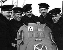
- The Sullivan Brothers, five sons who died together on the USS Juneau during World War II[65]
- Corey Taylor, vocalist from Slipknot and Stone Sour
- Mike van Arsdale, mixed martial artist, signed with the UFC
- Mona Van Duyn (1921–2004), winner of 1991 Pulitzer Prize for Poetry and 1992–1993 U.S. Poet Laureate; born in Waterloo
- Emily West (born 1981), country music singer/songwriter, signed with Capitol Records[66]
- Nancy Youngblut, actress
International relations
Twin towns – Sister cities
Waterloo, Iowa is twinned with:
 Gießen, Germany[67]
 Targovishte, Bulgaria (2002)[68]
References
- 1 2 "US Gazetteer files 2010". United States Census Bureau. Retrieved May 11, 2012.
- 1 2 "American FactFinder". United States Census Bureau. Retrieved May 11, 2012.
- 1 2 "Annual Estimates of the Resident Population for Incorporated Places: April 1, 2010 to July 1, 2014". Retrieved June 4, 2015.
- ↑ "Find a County". National Association of Counties. Retrieved June 7, 2011.
- ↑ "Iowa's Largest Cities". Quad City Times. February 10, 2011. Retrieved February 13, 2011.
- ↑ The History of Black Hawk County. Chicago: Western Historical Company. 1878. pp. 383 (pdf–375).
- ↑ Clymer, Floyd. Treasury of Early American Automobiles, 1877–1925 (New York: Bonanza Books, 1950), p.93.
- ↑ "City Profile".
- 1 2 3 4 5 Halpern, Rick; Horowitz, Roger (1999-03-01). Meatpackers: An Oral History of Black Packinghouse Workers and Their Struggle for Racial and Economic Equality. NYU Press. ISBN 9781583670057.
- 1 2 3 4 5 6 7 8 9 "Waterloo rallies to combat violence, racial divides". Des Moines Register. Retrieved 2016-02-15.
- 1 2 Foster, Deborah (2015-10-26). "The 10th Worst City for African Americans in the U.S. has a Story : This is How the Dream Derailed: The History of African Americans in Waterloo, Working At Rath, Where is Today's Local 46?". Medium. Retrieved 2016-02-15. hair space character in
|title=at position 66 (help) - 1 2 3 4 5 6 7 8 9 10 11 12 Schumaker, Kathryn (2013). "The Politics of Youth: Civil Rights Reform in the Waterloo Public Schools". The Annals of Iowa. 72. Retrieved 2016-02-14.
- 1 2 3 Jamison, Tim. "Report: Waterloo is Iowa's most segregated large city". Waterloo Cedar Falls Courier. Retrieved 2016-02-15.
- 1 2 Foster, Deborah (2015-10-26). "The 10th Worst City for African Americans in the U.S. has a Story : This is How the Dream Derailed: The History of African Americans in Waterloo, Working At Rath, Where is Today's Local 46?". Medium. Retrieved 2016-02-15. hair space character in
|title=at position 66 (help) - 1 2 3 4 5 6 Writer, AMIE STEFFEN Courier Staff. "Waterloo race relations still an issue 40 years after city report". Waterloo Cedar Falls Courier. Retrieved 2016-02-15.
- 1 2 3 4 5 6 7 8 "The Telegraph - Google News Archive Search". news.google.com. Retrieved 2016-02-15.
- ↑ Writer, ANDREW WIND, Courier Staff. "Vilsack looking to Waterloo in closing achievement gap for black males". Waterloo Cedar Falls Courier. Retrieved 2016-02-15.
- ↑ "The Worst Cities For Black Americans". The Huffington Post. Retrieved 2016-02-15.
- ↑ "Cedar River at Waterloo". National Weather Service. Retrieved August 4, 2011.
- ↑ "City Data website". Waterloo-Iowa. Retrieved November 24, 2010.
- ↑ Kottek, M.; Grieser, J. R.; Beck, C.; Rudolf, B.; Rubel, F. (2006). "World Map of the Köppen-Geiger climate classification updated" (PDF). Meteorol. Z. 15 (3): 259–263. doi:10.1127/0941-2948/2006/0130.
- ↑ "USDA Plant Hardiness Zone Map". USDA/Agricultural Research Center, PRISM Climate Group Oregon State University. Retrieved 2016-09-12.
- 1 2 3 4 "NowData - NOAA Online Weather Data". National Oceanic and Atmospheric Administration. Retrieved 2012-01-06.
- ↑ Mean monthly maxima and minima (i.e. the expected highest and lowest temperature readings at any point during the year or given month) calculated based on data at said location from 1981 to 2010.
- ↑ "Station Name: IA WATERLOO MUNI AP". National Oceanic and Atmospheric Administration. Retrieved 2016-09-12.
- ↑ "WMO Climate Normals for WATERLOO/WSO AP IA 1961–1990". National Oceanic and Atmospheric Administration. Retrieved 2016-09-12.
- ↑ "Annual Estimates of the Resident Population for Incorporated Places: April 1, 2010 to July 1, 2015". Retrieved July 2, 2016.
- ↑ U.S. Census Bureau. Census 2000. "Census Demographic Profiles, Waterloo, Iowa" (PDF). CenStats Databases. Retrieved 2009-01-31.
- ↑ U.S. Census Bureau. Census 2000. "QT-P1. Age Groups and Sex, Waterloo, Iowa". American FactFinder. <http://factfinder.census.gov>. Retrieved 2009-01-31.
- ↑ United States Census Bureau. "Cumulative Estimates of Population Change for Metropolitan Statistical Areas and Rankings: April 1, 2000 to July 1, 2008". Retrieved July 11, 2009.
- ↑ "Silos & Smokestacks National Heritage Area". Retrieved January 19, 2016.
- 1 2 3 "Waterloo Center for the Arts/Directory". Waterloo Center for the Arts. Retrieved August 4, 2011.
- ↑
- ↑ "Excitement builds for Obama's Waterloo, Iowa, appearance | Iowa news". siouxcityjournal.com. Retrieved 2016-08-19.
- ↑ "Obama Stops For 'Just One' More Beer - ABC News". Abcnews.go.com. 2012-08-14. Retrieved 2016-08-19.
- ↑ "The History of Our Theatre in Waterloo". WCP & BHCT. Retrieved August 4, 2011.
- ↑ Eldridge, Mary Beth. "Brief Biographies of Early Residents of Waterloo, Black Hawk Co., Iowa". Retrieved June 30, 2011.
- 1 2 3 4 5 "The Grout Museum District". homepage. Retrieved November 24, 2010.
- ↑
- ↑ "Waterloo Public Library Board of Trustees — Waterloo Public Library". Waterloo.lib.ia.us. 2016-06-30. Retrieved 2016-08-19.
- ↑ "About the Library Director — Waterloo Public Library". Waterloo.lib.ia.us. Retrieved 2016-08-19.
- 1 2 "History — Waterloo Public Library". Waterloo.lib.ia.us. Retrieved 2016-08-19.
- ↑ "Cate Blanchett in 'Carol': Cannes Review". The Hollywood Reporter. Retrieved 2016-02-15.
- ↑ "Jefferson Lines adds route to Waterloo, connects to eastern areas". Globe Gazette. June 19, 2009. Retrieved October 31, 2009.
- ↑ Russell, Shelley (April 14, 2014). "Waterloo missing 851 million gallons of water". KWWL News. Retrieved August 12, 2014.
- ↑ "Cedar Valley Alliance". Utilities. Retrieved November 30, 2010.
- ↑ "Greater Cedar Valley Alliance". fact sheet 2009. Retrieved November 30, 2010.
- ↑ Condon, Patrick (January 6, 2011). "Waterloo native Bachmann of Minnesota tests Iowa presidential waters". WCF Courier. Retrieved May 1, 2011.
- ↑ Fox, Margalit. "William M. Birenbaum, College Leader, Dies at 87", The New York Times, October 8, 2010. Accessed October 10, 2010
- ↑ "National Governors Association". Horace Boies. Retrieved December 2, 2010.
- ↑ Lohr, David. "Boy Killer: John Wayne Gacy". Crime Magazine. Retrieved June 27, 2011.
- ↑ "State of New Jersey". Office of the Lieutenant Governor. Retrieved December 4, 2010.
- ↑ "BALLOT*PEDIA". Kim Guadagno. Retrieved December 4, 2010.
- ↑ Allen, Anne Beiser (2000). An independent woman: the life of Lou Henry. Greenwood Press. pp. 5–9. ISBN 0-313-31466-7.
- ↑ "National Football League". MarTay Jenkins. Retrieved December 7, 2010.
- ↑ Van Matre, Lynn (December 4, 1988). "Bonnie Koloc". Chicago Tribune. Retrieved January 4, 2012.
- ↑ "John H. Leavitt, History of Waterloo, Waterloo Public Library".
- ↑ "National Football League". J.J. Moses profile. Retrieved December 7, 2010.
- ↑ 'Judge Mullan Dies Thursday In Rochester, THe Des Moines Register, March 9, 1919, pg. 1, 2
- ↑ Sulivan, Jim (December 30, 2007). "Official notice: Nemmers ready to hang up his whistle". WCF Courier. Retrieved March 17, 2011.
- ↑ "Pro-Football-Reference". Reggie Roby bio. Retrieved December 7, 2010.
- ↑ "PRO-FOOTBALL Reference". Zud Schammel. Retrieved December 17, 2010.
- ↑ "DiVA station". Tracie Spencer bio. Retrieved December 6, 2010.
- ↑ "Suzanne Stephens - Clarinet, Basset-Horn and Bass Clarinet". Stockhausen.org. Retrieved 2016-08-19.
- ↑ John R. Satterfield, We Band of Brothers: The Sullivans & World War II (Parkersburg, IA: Mid-Prairie Books, 1995). ISBN 0-931209-58-7
- ↑ Bialas, Michael (May 18, 2010). "Finally on the Road, Emily West Keeps 'Em Laughing, Crying". The Huffington Post. Retrieved March 17, 2011.
- ↑ "Gießen: Städtepartnerschaften" [Giessen: Twin towns] (in German). Stadt Gießen. Archived from the original on April 13, 2013. Retrieved August 1, 2013.
- ↑ "International Contacts". Targovishte Municipality. Retrieved August 29, 2013.
External links
| Wikimedia Commons has media related to Waterloo, Iowa. |
- City website
- Waterloo Convention and Visitors Bureau
- Community Foundation of Northeast Iowa
- City of Waterloo Brownfields Redevelopment Website
- City of Waterloo Economic Development Website
- Waterloo Public Library
- Waterloo Chamber of Commerce
- Waterloo Police Department
- Waterloo Community School District
- City Data Comprehensive statistical data and more about Waterloo, Iowa
- Historic
Coordinates: 42°29′33″N 92°20′46″W / 42.492436°N 92.346161°W
Municipalities and communities of Black Hawk County, Iowa, United States | ||
|---|---|---|
| Cities | ||
| Townships | ||
| CDP | ||
| Other unincorporated communities | ||
| Footnotes | ‡This populated place also has portions in an adjacent county or counties | |