Van Buren County, Iowa
| Van Buren County, Iowa | |
|---|---|
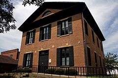 Van Buren County Courthouse | |
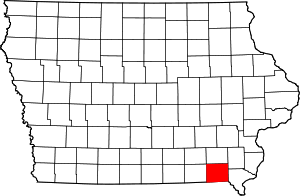 Location in the U.S. state of Iowa | |
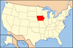 Iowa's location in the U.S. | |
| Founded | December 7, 1836 |
| Named for | Martin Van Buren |
| Seat | Keosauqua |
| Largest city | Keosauqua |
| Area | |
| • Total | 491 sq mi (1,272 km2) |
| • Land | 485 sq mi (1,256 km2) |
| • Water | 5.7 sq mi (15 km2), 1.2% |
| Population | |
| • (2010) | 7,570 |
| • Density | 16/sq mi (6/km²) |
| Congressional district | 2nd |
| Time zone | Central: UTC-6/-5 |
| Website |
vanburencoia |
Van Buren County is a county located in the U.S. state of Iowa. As of the 2010 census, the population was 7,570.[1] The county seat is Keosauqua,[2] which contains the oldest continuously operational courthouse in the state of Iowa, and second oldest in the United States.
History

Van Buren County was formed on December 7, 1836 as a part of Wisconsin Territory, and was split off from Des Moines County. It was named for President Martin Van Buren. It became a part of Iowa Territory (later the state of Iowa) when that territory was organized on July 4, 1838.[3]
The county's courthouse was built in September 1843 in the style of Greek Revival and stands as Iowa's oldest, and the nation's second oldest, courthouse in operation.[4]
Geography
According to the U.S. Census Bureau, the county has a total area of 491 square miles (1,270 km2), of which 485 square miles (1,260 km2) is land and 5.7 square miles (15 km2) (1.2%) is water.[5]
Major highways
Adjacent counties
- Jefferson County (north)
- Henry County (northeast)
- Lee County (east)
- Clark County, Missouri (southeast)
- Scotland County, Missouri (southwest)
- Davis County (west)
Demographics
| Historical population | |||
|---|---|---|---|
| Census | Pop. | %± | |
| 1850 | 12,270 | — | |
| 1860 | 17,081 | 39.2% | |
| 1870 | 17,672 | 3.5% | |
| 1880 | 17,043 | −3.6% | |
| 1890 | 16,253 | −4.6% | |
| 1900 | 17,354 | 6.8% | |
| 1910 | 15,020 | −13.4% | |
| 1920 | 14,060 | −6.4% | |
| 1930 | 12,603 | −10.4% | |
| 1940 | 12,053 | −4.4% | |
| 1950 | 11,007 | −8.7% | |
| 1960 | 9,778 | −11.2% | |
| 1970 | 8,643 | −11.6% | |
| 1980 | 8,626 | −0.2% | |
| 1990 | 7,676 | −11.0% | |
| 2000 | 7,809 | 1.7% | |
| 2010 | 7,570 | −3.1% | |
| Est. 2015 | 7,344 | [6] | −3.0% |
| U.S. Decennial Census[7] 1790-1960[8] 1900-1990[9] 1990-2000[10] 2010-2013[1] | |||
2010 census

As of the census[11] of 2010, there were 7,570 people, 3,108 households, and 2,058 families residing in the county. The population density was 15.614/sq mi (6.029/km2) people per square mile. There were 3,670 housing units at an average density of 7.570/sq mi (2.923/km2) per square mile. The racial makeup of the county was 98.3% White, 0.2% Black or African American, 0.1% Native American, 0.5% Asian, 0.2% from other races, and 0.7% from two or more races. 1.2% of the population were Hispanic or Latino of any race.
There were 3,108 households out of which 25.4% had children under the age of 18 living with them, 55.4% were married couples living together, 7.0% had a female householder with no husband present, and 33.8% were non-families. 27.7% of all households were made up of individuals and 33.6% had someone living alone who was 65 years of age or older. The average household size was 2.40 and the average family size was 2.97.
In the county the population was spread out with 24.1% under the age of 18 and 19.8% who were 65 years of age or older. The median age was 43.3 years. For every 100 females there were 100.6 males.
As of the 2000 census, the median income for a household in the county was $31,094, and the median income for a family was $36,420. Males had a median income of $27,379 versus $20,925 for females. The per capita income for the county was $15,748. About 8.70% of families and 12.70% of the population were below the poverty line, including 14.00% of those under age 18 and 15.60% of those age 65 or over.
Communities
Cities
Census-designated places
Unincorporated communities
- Iowaville
- Lebanon
- Mt. Zion
- Pittsburg
- Selma
- Winchester
Townships
According to the 1850 US Census Records.
- Birmingham Township
- Bonaparte Township
- Cedar Township
- Chequest Township
- Des Moines Township
- Farmington Township
- Harrisburg Township
- Jackson Township
- Keosauqua Township
- Lick Creek Township
- Union Township
- Van Buren Township
- Vernon Township
- Village Township
- Washington Township
Population ranking
The population ranking of the following table is based on the 2010 census of Van Buren County.[12]
† county seat
| Rank | City/Town/etc. | Municipal type | Population (2010 Census)
|
|---|---|---|---|
| 1 | † Keosauqua | City | 1,006 |
| 2 | Farmington | City | 664 |
| 3 | Birmingham | City | 448 |
| 4 | Milton | City | 443 |
| 5 | Bonaparte | City | 433 |
| 6 | Stockport | City | 296 |
| 7 | Cantril | City | 222 |
| 8 | Douds | CDP | 152 |
| 9 | Leando | CDP | 115 |
| 10 | Mount Sterling | CDP | 36 |
See also
References
- 1 2 "State & County QuickFacts". United States Census Bureau. Retrieved July 20, 2014.
- ↑ "Find a County". National Association of Counties. Retrieved 2011-06-07.
- ↑ "WI: Individual County Chronologies". publications.newberry.org. Retrieved 2016-09-28.
- ↑ Van Buren County
- ↑ "US Gazetteer files: 2010, 2000, and 1990". United States Census Bureau. 2011-02-12. Retrieved 2011-04-23.
- ↑ "County Totals Dataset: Population, Population Change and Estimated Components of Population Change: April 1, 2010 to July 1, 2015". Retrieved July 2, 2016.
- ↑ "U.S. Decennial Census". United States Census Bureau. Retrieved July 20, 2014.
- ↑ "Historical Census Browser". University of Virginia Library. Retrieved July 20, 2014.
- ↑ "Population of Counties by Decennial Census: 1900 to 1990". United States Census Bureau. Retrieved July 20, 2014.
- ↑ "Census 2000 PHC-T-4. Ranking Tables for Counties: 1990 and 2000" (PDF). United States Census Bureau. Retrieved July 20, 2014.
- ↑ "Population & Housing Occupancy Status 2010". United States Census Bureau American FactFinder. Retrieved 2011-06-03.
- ↑ http://www.census.gov/2010census/
External links
| Wikimedia Commons has media related to Van Buren County, Iowa. |
 |
Jefferson County | Henry County | | |
| Davis County | |
Lee County | ||
| ||||
| | ||||
| Scotland County, Missouri | Clark County, Missouri |
Municipalities and communities of Van Buren County, Iowa, United States | ||
|---|---|---|
| Cities | ||
| CDPs | ||
| Other unincorporated communities | ||
| Ghost town | ||

Coordinates: 40°45′00″N 91°57′06″W / 40.75000°N 91.95167°W