Stuart, Iowa
| Stuart, Iowa | |
|---|---|
| City | |
|
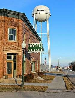
Hotel Stuart | |
 Location of Stuart, Iowa | |
| Coordinates: 41°30′13″N 94°19′14″W / 41.50361°N 94.32056°WCoordinates: 41°30′13″N 94°19′14″W / 41.50361°N 94.32056°W | |
| Country |
|
| State |
|
| Counties | Guthrie, Adair |
| Township | Lincoln |
| Area[1] | |
| • Total | 2.58 sq mi (6.68 km2) |
| • Land | 2.58 sq mi (6.68 km2) |
| • Water | 0 sq mi (0 km2) |
| Elevation | 1,207 ft (368 m) |
| Population (2010)[2] | |
| • Total | 1,648 |
| • Estimate (2012[3]) | 1,624 |
| • Density | 638.8/sq mi (246.6/km2) |
| Time zone | Central (CST) (UTC-6) |
| • Summer (DST) | CDT (UTC-5) |
| ZIP code | 50250 |
| Area code(s) | 515 |
| FIPS code | 19-75990 |
| GNIS feature ID | 0462041 |
Stuart is a city in Lincoln Township, Adair County, and in Stuart Township, Guthrie County, in the U.S. state of Iowa. That part of the city within Guthrie County is part of the Des Moines–West Des Moines Metropolitan Statistical Area. The population was 1,648 at the 2010 census.
History
Stuart had its start in the late 1860s by the building of the Chicago, Rock Island and Pacific Railroad through that territory.[4] It is named for Charles Stuart, who was instrumental in bringing the railroad to the city.[5]
Geography
According to the United States Census Bureau, the city has a total area of 2.58 square miles (6.68 km2), all of it land.[1]
Demographics
| Historical Populations | ||
|---|---|---|
| Year | Pop. | ±% |
| 1880 | 1,994 | — |
| 1890 | 2,052 | +2.9% |
| 1900 | 2,079 | +1.3% |
| 1910 | 1,826 | −12.2% |
| 1920 | 1,716 | −6.0% |
| 1930 | 1,626 | −5.2% |
| 1940 | 1,611 | −0.9% |
| 1950 | 1,500 | −6.9% |
| 1960 | 1,486 | −0.9% |
| 1970 | 1,354 | −8.9% |
| 1980 | 1,650 | +21.9% |
| 1990 | 1,522 | −7.8% |
| 2000 | 1,712 | +12.5% |
| 2010 | 1,648 | −3.7% |
| 2014 | 1,615 | −2.0% |
| 2015 | 1,602 | −0.8% |
| Source:"American FactFinder". United States Census Bureau. and Iowa Data Center Source: | ||
2010 census
As of the census[2] of 2010, there were 1,648 people, 667 households, and 423 families residing in the city. The population density was 638.8 inhabitants per square mile (246.6/km2). There were 746 housing units at an average density of 289.1 per square mile (111.6/km2). The racial makeup of the city was 97.1% White, 0.4% African American, 0.2% Native American, 0.2% Asian, 0.6% from other races, and 1.6% from two or more races. Hispanic or Latino of any race were 2.5% of the population.
There were 667 households of which 31.0% had children under the age of 18 living with them, 46.9% were married couples living together, 11.5% had a female householder with no husband present, 4.9% had a male householder with no wife present, and 36.6% were non-families. 31.0% of all households were made up of individuals and 15.1% had someone living alone who was 65 years of age or older. The average household size was 2.34 and the average family size was 2.91.
The median age in the city was 41.5 years. 24.5% of residents were under the age of 18; 6.6% were between the ages of 18 and 24; 22.9% were from 25 to 44; 25.6% were from 45 to 64; and 20.4% were 65 years of age or older. The gender makeup of the city was 48.4% male and 51.6% female.
2000 census
As of the census[7] of 2000, there were 1,712 people, 695 households, and 460 families residing in the city. The population density was 846.0 people per square mile (327.2/km²). There were 742 housing units at an average density of 366.7 per square mile (141.8/km²). The racial makeup of the city was 98.36% White, 0.06% African American, 0.06% Native American, 0.18% Asian, 0.53% from other races, and 0.82% from two or more races. Hispanic or Latino of any race were 1.11% of the population.
There were 695 households out of which 30.8% had children under the age of 18 living with them, 51.9% were married couples living together, 10.5% had a female householder with no husband present, and 33.7% were non-families. 29.6% of all households were made up of individuals and 17.0% had someone living alone who was 65 years of age or older. The average household size was 2.37 and the average family size was 2.92.
24.3% were under the age of 18, 7.5% from 18 to 24, 25.6% from 25 to 44, 20.9% from 45 to 64, and 21.7% were 65 years of age or older. The median age was 40 years. For every 100 females there were 93.7 males. For every 100 females age 18 and over, there were 85.4 males.
The median income for a household in the city was $33,491, and the median income for a family was $41,600. Males had a median income of $31,156 versus $21,638 for females. The per capita income for the city was $17,113. About 6.6% of families and 8.4% of the population were below the poverty line, including 9.8% of those under age 18 and 6.1% of those age 65 or over.
Notable people
- Osborn Deignan - received Medal of Honor for actions in the Spanish–American War
- William R. Peers - United States Army Lieutenant General - Best known for the Peers Commission of the My Lai Massacre and for service with Detachment 101
- Buck Shaw - offensive tackle who blocked for George Gipp on Knute Rockne's first undefeated University of Notre Dame football team, winner of two Sugar Bowls as Head Coach of Santa Clara University, the first football head coach at the United States Air Force Academy, the Philadelphia Eagles head coach who won 1960 NFL Championship, and the only coach to have beaten Vince Lombardi in the playoffs.
- A. H. Wilkinson- Wisconsin state senator; born in Stuart.
See also
Four buildings in town are listed on the National Register of Historic Places:
- The former All Saints Catholic Church (1910)
- Chicago, Rock Island and Pacific Railroad: Stuart Passenger Station (1869)
- Masonic Temple Building (1894)
- Sexton Hotel (1907)
References
- 1 2 "US Gazetteer files 2010". United States Census Bureau. Retrieved 2012-05-11.
- 1 2 "American FactFinder". United States Census Bureau. Retrieved 2012-05-11.
- ↑ "Population Estimates". United States Census Bureau. Retrieved 2013-05-23.
- ↑ History of Guthrie and Adair Counties, Iowa. Continental Historical Company. 1884. p. 732.
- ↑ Kilburn, Lucian Moody (1915). History of Adair County, Iowa, and Its People, Volume 1. Pioneer Publishing Company. p. 160.
- ↑ "Census of Population and Housing". Census.gov. Retrieved June 4, 2015.
- ↑ "American FactFinder". United States Census Bureau. Retrieved 2008-01-31.
External links
| Wikimedia Commons has media related to Stuart, Iowa. |
- Official City Website
- City-Data Comprehensive Statistical Data and more about Stuart
Municipalities and communities of Adair County, Iowa, United States | ||
|---|---|---|
| Cities | ||
| Townships | ||
| Unincorporated communities | ||
| Footnotes | ‡This populated place also has portions in an adjacent county or counties | |
Municipalities and communities of Guthrie County, Iowa, United States | ||
|---|---|---|
| Cities | ||
| CDPs | ||
| Unincorporated communities | ||
| Footnotes | ‡This populated place also has portions in an adjacent county or counties | |