Worth County, Iowa
| Worth County, Iowa | |
|---|---|
|
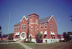
The courthouse in Northwood is on the NRHP. | |
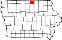 Location in the U.S. state of Iowa | |
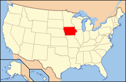 Iowa's location in the U.S. | |
| Founded | 1851 |
| Named for | William Jenkins Worth |
| Seat | Northwood |
| Largest city | Northwood |
| Area | |
| • Total | 402 sq mi (1,041 km2) |
| • Land | 400 sq mi (1,036 km2) |
| • Water | 1.8 sq mi (5 km2), 0.5% |
| Population | |
| • (2010) | 7,598 |
| • Density | 19/sq mi (7/km²) |
| Congressional district | 1st |
| Time zone | Central: UTC-6/-5 |
| Website |
www |
Worth County is a county located in the U.S. state of Iowa. As of the 2010 census, the population was 7,598.[1] The county seat is in Northwood.[2] The county was founded in 1851 and named for Major General William Jenkins Worth (1794–1849), an officer in both the Seminole War and the Mexican-American War.
Worth County is part of the Mason City, IA Micropolitan Statistical Area.
Geography
According to the U.S. Census Bureau, the county has a total area of 402 square miles (1,040 km2), of which 400 square miles (1,000 km2) is land and 1.8 square miles (4.7 km2) (0.5%) is water.[3] It is the fourth-smallest county in Iowa by land area and third-smallest by total area.
Major highways
Adjacent counties
- Freeborn County, Minnesota (north)
- Mower County, Minnesota (northeast)
- Mitchell County (east)
- Cerro Gordo County (south)
- Winnebago County (west)
Demographics
| Historical population | |||
|---|---|---|---|
| Census | Pop. | %± | |
| 1860 | 756 | — | |
| 1870 | 2,892 | 282.5% | |
| 1880 | 7,953 | 175.0% | |
| 1890 | 9,247 | 16.3% | |
| 1900 | 10,887 | 17.7% | |
| 1910 | 9,950 | −8.6% | |
| 1920 | 11,630 | 16.9% | |
| 1930 | 11,164 | −4.0% | |
| 1940 | 11,449 | 2.6% | |
| 1950 | 11,068 | −3.3% | |
| 1960 | 10,259 | −7.3% | |
| 1970 | 8,968 | −12.6% | |
| 1980 | 9,075 | 1.2% | |
| 1990 | 7,991 | −11.9% | |
| 2000 | 7,909 | −1.0% | |
| 2010 | 7,598 | −3.9% | |
| Est. 2015 | 7,569 | [4] | −0.4% |
| U.S. Decennial Census[5] 1790-1960[6] 1900-1990[7] 1990-2000[8] 2010-2013[1] | |||
2010 census
The 2010 census recorded a population of 7,598 in the county, with a population density of 18.9950/sq mi (7.3340/km2). There were 3,548 housing units, of which 3,172 were occupied.[9]
2000 census

As of the census[10] of 2000, there were 7,909 people, 3,278 households, and 2,265 families residing in the county. The population density was 20 people per square mile (8/km²). There were 3,534 housing units at an average density of 9 per square mile (3/km²). The racial makeup of the county was 98.37% White, 0.28% Black or African American, 0.09% Native American, 0.14% Asian, 0.01% Pacific Islander, 0.42% from other races, and 0.70% from two or more races. 1.57% of the population were Hispanic or Latino of any race.
There were 3,278 households out of which 30.40% had children under the age of 18 living with them, 58.10% were married couples living together, 7.30% had a female householder with no husband present, and 30.90% were non-families. 27.60% of all households were made up of individuals and 14.30% had someone living alone who was 65 years of age or older. The average household size was 2.38 and the average family size was 2.88.
In the county the population was spread out with 24.30% under the age of 18, 6.50% from 18 to 24, 26.30% from 25 to 44, 23.50% from 45 to 64, and 19.40% who were 65 years of age or older. The median age was 41 years. For every 100 females there were 98.50 males. For every 100 females age 18 and over, there were 95.20 males.
The median income for a household in the county was $36,444, and the median income for a family was $41,763. Males had a median income of $27,927 versus $20,897 for females. The per capita income for the county was $16,952. About 6.30% of families and 8.30% of the population were below the poverty line, including 9.60% of those under age 18 and 7.80% of those age 65 or over.
Communities
Cities
Unincorporated community
Townships
Population ranking
The population ranking of the following table is based on the 2010 census of Worth County.[11]
† county seat
| Rank | City/Town/etc. | Municipal type | Population (2010 Census)
|
|---|---|---|---|
| 1 | † Northwood | City | 1,989 |
| 2 | Manly | City | 1,323 |
| 3 | Fertile | City | 370 |
| 4 | Kensett | City | 266 |
| 5 | Grafton | City | 252 |
| 6 | Hanlontown | City | 226 |
| 7 | Joice | City | 222 |
| 8 | Bolan | CDP | 33 |
See also
References
- 1 2 "State & County QuickFacts". United States Census Bureau. Retrieved July 20, 2014.
- ↑ "Find a County". National Association of Counties. Archived from the original on May 31, 2011. Retrieved 2011-06-07.
- ↑ "US Gazetteer files: 2010, 2000, and 1990". United States Census Bureau. 2011-02-12. Retrieved 2011-04-23.
- ↑ "County Totals Dataset: Population, Population Change and Estimated Components of Population Change: April 1, 2010 to July 1, 2015". Retrieved July 2, 2016.
- ↑ "U.S. Decennial Census". United States Census Bureau. Archived from the original on May 11, 2015. Retrieved July 20, 2014.
- ↑ "Historical Census Browser". University of Virginia Library. Retrieved July 20, 2014.
- ↑ "Population of Counties by Decennial Census: 1900 to 1990". United States Census Bureau. Retrieved July 20, 2014.
- ↑ "Census 2000 PHC-T-4. Ranking Tables for Counties: 1990 and 2000" (PDF). United States Census Bureau. Retrieved July 20, 2014.
- ↑ "Population & Housing Occupancy Status 2010". United States Census Bureau American FactFinder. Retrieved 2011-06-19.
- ↑ "American FactFinder". United States Census Bureau. Retrieved 2008-01-31.
- ↑ http://www.census.gov/2010census/
External links
| Wikimedia Commons has media related to Worth County, Iowa. |
 |
Freeborn County, Minnesota | Mower County, Minnesota | | |
| Winnebago County | |
Mitchell County | ||
| ||||
| | ||||
| Cerro Gordo County |
Municipalities and communities of Worth County, Iowa, United States | ||
|---|---|---|
| Cities | ||
| Townships | ||
| CDP | ||
Coordinates: 43°22′44″N 93°15′26″W / 43.37889°N 93.25722°W