Ida County, Iowa
| Ida County, Iowa | |
|---|---|
|
| |
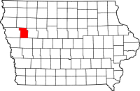 Location in the U.S. state of Iowa | |
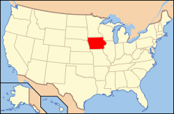 Iowa's location in the U.S. | |
| Founded | 1851 |
| Seat | Ida Grove |
| Largest city | Ida Grove |
| Area | |
| • Total | 432 sq mi (1,119 km2) |
| • Land | 432 sq mi (1,119 km2) |
| • Water | 0.5 sq mi (1 km2), 0.1% |
| Population | |
| • (2010) | 7,089 |
| • Density | 16/sq mi (6/km²) |
| Congressional district | 4th |
| Time zone | Central: UTC-6/-5 |
| Website |
www |
Ida County is a county located in the U.S. state of Iowa. As of the 2010 census, the population was 7,089.[1] The county seat is Ida Grove.[2] The county was formed on January 15, 1851. It was probably named after Ida Smith, the first child of European immigrants to be born in this region.
Geography
According to the U.S. Census Bureau, the county has a total area of 432 square miles (1,120 km2), of which 432 square miles (1,120 km2) is land and 0.5 square miles (1.3 km2) (0.1%) is water.[3]
Major highways
Adjacent counties
- Cherokee County (north)
- Sac County (east)
- Crawford County (south)
- Woodbury County (west)
Demographics
| Historical population | |||
|---|---|---|---|
| Census | Pop. | %± | |
| 1860 | 43 | — | |
| 1870 | 226 | 425.6% | |
| 1880 | 4,382 | 1,838.9% | |
| 1890 | 10,705 | 144.3% | |
| 1900 | 12,327 | 15.2% | |
| 1910 | 11,296 | −8.4% | |
| 1920 | 11,689 | 3.5% | |
| 1930 | 11,933 | 2.1% | |
| 1940 | 11,047 | −7.4% | |
| 1950 | 10,697 | −3.2% | |
| 1960 | 10,269 | −4.0% | |
| 1970 | 9,283 | −9.6% | |
| 1980 | 8,908 | −4.0% | |
| 1990 | 8,365 | −6.1% | |
| 2000 | 7,837 | −6.3% | |
| 2010 | 7,089 | −9.5% | |
| Est. 2015 | 7,028 | [4] | −0.9% |
| U.S. Decennial Census[5] 1790-1960[6] 1900-1990[7] 1990-2000[8] 2010-2013[1] | |||
2010 census
The 2010 census recorded a population of 7,089 in the county, with a population density of 16.4207/sq mi (6.3401/km2). There were 3,426 housing units, of which 3,052 were occupied.[9]
2000 census

As of the census[10] of 2000, there were 7,837 people, 3,213 households, and 2,184 families residing in the county. The population density was 18 people per square mile (7/km²). There were 3,506 housing units at an average density of 8 per square mile (3/km²). The racial makeup of the county was 99.02% White, 0.10% Black or African American, 0.06% Native American, 0.24% Asian, 0.15% from other races, and 0.42% from two or more races. 0.47% of the population were Hispanic or Latino of any race.
There were 3,213 households out of which 29.40% had children under the age of 18 living with them, 59.50% were married couples living together, 5.90% had a female householder with no husband present, and 32.00% were non-families. 29.30% of all households were made up of individuals and 15.90% had someone living alone who was 65 years of age or older. The average household size was 2.39 and the average family size was 2.95.
In the county the population was spread out with 25.50% under the age of 18, 6.10% from 18 to 24, 24.00% from 25 to 44, 22.70% from 45 to 64, and 21.80% who were 65 years of age or older. The median age was 42 years. For every 100 females there were 93.90 males. For every 100 females age 18 and over, there were 91.40 males.
The median income for a household in the county was $34,805, and the median income for a family was $43,179. Males had a median income of $29,002 versus $19,417 for females. The per capita income for the county was $18,675. About 5.70% of families and 8.80% of the population were below the poverty line, including 9.10% of those under age 18 and 8.60% of those age 65 or over.
Communities
Population ranking
The population ranking of the following table is based on the 2010 census of Ida County.[11]
† county seat
| Rank | City/Town/etc. | Municipal type | Population (2010 Census)
|
|---|---|---|---|
| 1 | † Ida Grove | City | 2,142 |
| 2 | Holstein | City | 1,396 |
| 3 | Battle Creek | City | 713 |
| 4 | Galva | City | 434 |
| 5 | Arthur | City | 206 |
See also
- Ida County Courthouse
- National Register of Historic Places listings in Ida County, Iowa
- Waveland Round Barn, listed on the National Register of Historic Places
References
- 1 2 "State & County QuickFacts". United States Census Bureau. Retrieved July 17, 2014.
- ↑ "Find a County". National Association of Counties. Retrieved 2011-06-07.
- ↑ "US Gazetteer files: 2010, 2000, and 1990". United States Census Bureau. 2011-02-12. Retrieved 2011-04-23.
- ↑ "County Totals Dataset: Population, Population Change and Estimated Components of Population Change: April 1, 2010 to July 1, 2015". Retrieved July 2, 2016.
- ↑ "U.S. Decennial Census". United States Census Bureau. Retrieved July 17, 2014.
- ↑ "Historical Census Browser". University of Virginia Library. Retrieved July 17, 2014.
- ↑ "Population of Counties by Decennial Census: 1900 to 1990". United States Census Bureau. Retrieved July 17, 2014.
- ↑ "Census 2000 PHC-T-4. Ranking Tables for Counties: 1990 and 2000" (PDF). United States Census Bureau. Retrieved July 17, 2014.
- ↑ "Population & Housing Occupancy Status 2010". United States Census Bureau American FactFinder. Retrieved May 18, 2011.
- ↑ "American FactFinder". United States Census Bureau. Retrieved 2008-01-31.
- ↑ http://www.census.gov/2010census/
11. Some Historic Markers in Iowa By Susie Webb Wright Published at Iowa City Iowa by The State Historical Society of Iowa 1943
A bronze plaque place in Ida Grove by The Daughters of the American Revolution on Nov. 13, 1929 Which states Near this spot was born the first white child in Ida County, Iowa. Ida Smith 1856
External links
| Wikimedia Commons has media related to Ida County, Iowa. |
 |
Cherokee County | | ||
| Woodbury County | |
Sac County | ||
| ||||
| | ||||
| Crawford County |
Municipalities and communities of Ida County, Iowa, United States | ||
|---|---|---|
| Cities | ||
Coordinates: 42°23′12″N 95°30′52″W / 42.38667°N 95.51444°W