Clinton, Iowa
| Clinton | |
|---|---|
| City | |
 | |
| Motto: So many things to do - With a river view! | |
 Location in the State of Iowa | |
 Clinton Location in the United States | |
| Coordinates: 41°50′49″N 90°12′26″W / 41.84694°N 90.20722°WCoordinates: 41°50′49″N 90°12′26″W / 41.84694°N 90.20722°W | |
| Country |
|
| State |
|
| County | Clinton |
| Incorporated | 1836 |
| Government | |
| • Mayor | Mark Vulich |
| Area[1] | |
| • Total | 38.01 sq mi (98.45 km2) |
| • Land | 35.15 sq mi (91.04 km2) |
| • Water | 2.86 sq mi (7.41 km2) |
| Elevation | 600 ft (185 m) |
| Population (2010)[2] | |
| • Total | 26,885 |
| • Estimate (2012[3]) | 26,647 |
| • Rank | 18th in Iowa |
| • Density | 764.9/sq mi (295.3/km2) |
| Time zone | CST (UTC-6) |
| • Summer (DST) | CDT (UTC-5) |
| ZIP codes | 52732-52734, 52736, 52771 |
| Area code(s) | 563 |
| FIPS code | 19-14430 |
| GNIS feature ID | 0455480 |
| Website | http://www.cityofclintoniowa.us/ |
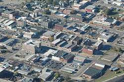
Clinton is a city in and the county seat of Clinton County, Iowa, United States.[4] The population was 26,885 as of 2010. Clinton, along with DeWitt, Iowa (also located in Clinton County), was named in honor of the sixth governor of New York, DeWitt Clinton. Clinton is the principal city of the Clinton Micropolitan Statistical Area, which is coterminous with Clinton County.[5] Clinton was incorporated on January 26, 1857.[6]
History

Among the first settlers of European origin in the Clinton area was Elijah Buell, who built a log cabin on July 25, 1835 and established the town of Lyons, named after the French city of the same name. Lyons later merged with Clinton.
Clinton was platted as the town of New York in 1836 by Joseph Bartlett.[7] In March 1837, Noble and Sarah Gregory Perrin purchased 136 acres (0.55 km2) of land in what is now Clinton and raised their family in a cabin located approximately at the foot of the railroad bridge.[8] Their oldest daughter, Valeria, married Dr. Augustus Lafayette Ankeny, who participated in the Blackhawk war and came to Lyons in April 1850.
Mary Perrin, born September 26, 1837, was the first female child of European ancestry born in Clinton County. In 1839, as in most early river towns, the town consisted of a sprinkling of cabins, two stores and a tavern. In 1855, the Chicago, Iowa, Nebraska Railroad announced it would cross the river at Little Rock Island adjacent to Bartlett's settlement. The Iowa Land Company was organized on May 26, 1855 and on July 4, bought Bartlett's tract and renamed it Clinton, in honor of DeWitt Clinton, two-time governor of New York and one of the driving forces behind the construction of the Erie Canal.
On November 10, 1855, the first plat of the city of Clinton was signed. On January 26, 1857 the city was granted a charter and on March 7, the charter was adopted. On April 5, 1859, the amended charter of the city was adopted, which lasted until a general charter was adopted in 1867. In June 1859 the railroad line was completed to Cedar Rapids. The first train crossed from the Illinois shore to Little Rock Island at noon, January 9, 1860, and was ferried from there to the Iowa shore. In January 1864, construction was started on the span from Little Rock Island to the Iowa shore and was completed on January 6, 1865. The original single track railroad bridge was replaced by a double track bridge that was completed in 1909.
The first public school in Clinton was conducted in a log house near the W.J. Young upper mill. It was erected in the winter of 1855-56 and Isaac Baldwin was its first teacher. St. Irenaeus School was opened in 1852.

The original Lyons-Fulton Bridge was constructed in 1891 (replaced by the Mark N. Morris Memorial Bridge in 1975), followed by the Clinton High Bridge in 1892 (replaced by the Gateway Bridge in 1956).
Between the 1850s and 1900, the cities of Lyons and Clinton quickly became centers of the lumber industry and were regarded as the "Lumber Capital of the World." Huge log rafts were floated down the river from Wisconsin and Minnesota, cut into lumber at Clinton, then shipped to the growing communities via the river and the railroads. Companies owned by the W.J. Young, Chancy Lamb, George M. and Charles F. Curtis (Curtis Bros. & Co), David Joyce, Silas W. Gardiner Lyons, and Friedrich Weyerhäuser families soon became among the largest in the nation. In the 1880s and 1890s Clinton boasted 13 resident millionaires, more millionaires per capita than any other town or city in the nation.
In 1877 the noted pianist Carl Lachmund founded the German Conservatorium of Music in Clinton.
The largest, most elaborate party ever held in Clinton celebrated the debut of Emma Lamb and the twentieth wedding anniversary of her parents, Artemus and Henrietta Sabrina Smith Lamb on October 13, 1885. Fellow lumber baron F.C. Weyerhauser, his wife and daughter attended together with several hundred guests all attired in formal wear.[9]
The era of opulence came to an end by 1900, as the northern forests were depleted. The sawmills closed, but the railroad and river, providing economical transportation in all directions, attracted manufacturing and heavy industry. The city still boasts a number of magnificent Victorian mansions, including the Curtis Mansion, now the home of the Clinton Women's Club.
The American Protective Association (APA) was founded in Clinton on March 13, 1887 by Attorney Henry Francis Bowers.
In 1941, with Howard Judd as coach, Clinton High School won the first of its 11 state championships in swimming.[10] This string included five straight championships between 1954 and 1958 and produced 39 individual All Americans and 14 Individual All American Relay Teams (The Howard Judd Story Reception Program June 5, 1966). Clinton’s athletic successes were added to in 1953 when St. Mary’s won the state basketball championship.

Other great athletic triumphs were achieved by the 1964 Clinton High School boys’ baseball team winning the State Championship, the 1991 Clinton Giants winning the Midwest League baseball championship and by the 1992 Clinton High School boys’ basketball team (referred to as the '92 Crew) winning the State Championship.
On April 27, 1951, the Mississippi crested at 20.7 feet (6.3 m); then on April 26, 1952, it crested again at 20.9 feet (6.4 m). All of that was an exercise compared with the crest on April 28, 1965, which at 24.85 feet (7.57 m) was the highest ever recorded.[11]
Construction of the Gateway Bridge (Illinois-Iowa) was started in August, 1954, was finished in May 1956. It opened on July 1, 1956.
In 2005, Clinton, along with Coon Rapids, Iowa and Sioux City, was awarded one of the inaugural Iowa Great Places designations.[12] This award brought to Clinton a $1 million state budget allocation for cultural and landscape improvements along the city's riverfront.
In 2008, the Archer Daniels Midland corn processing plant added a cogeneration plant to provide for its electrical needs, which burns coal and leftover corn for the energy.
In January 2011, Clinton opened the world's first-ever site of noted rapper Flavor Flav's fast food chain, Flav's Fried Chicken. This was due to the fact that Flav's business partner, Nick Cimino, is a Clinton native and felt that the restaurant's opening would be good for the community.[13] The restaurant was closed down after a mere four months due to low staff retention and bad checks, among other concerns. Rapper Flav has gone on record stating "that restaurant manager Nick Cimino wasn't running the business right.".[14]
Geography
Clinton is located at 41°50′49″N 90°12′26″W / 41.84694°N 90.20722°W (41.846863, -90.207330).[15]
According to the United States Census Bureau, the city has a total area of 38.01 square miles (98.45 km2), of which 35.15 square miles (91.04 km2) is land and 2.86 square miles (7.41 km2) is water.[1]
Clinton is on the western shore of the Mississippi River and is the easternmost city in Iowa. The Upper Mississippi River National Wildlife and Fish Refuge passes through Clinton along the river.
The pool of the Mississippi River above Lock and Dam No. 13 is the widest section of the river at 1.8 miles (2.9 km) across.[16]
Demographics
| Historical population | |||
|---|---|---|---|
| Census | Pop. | %± | |
| 1870 | 6,129 | — | |
| 1880 | 9,052 | 47.7% | |
| 1890 | 13,619 | 50.5% | |
| 1900 | 22,698 | 66.7% | |
| 1910 | 25,577 | 12.7% | |
| 1920 | 24,161 | −5.5% | |
| 1930 | 25,726 | 6.5% | |
| 1940 | 26,270 | 2.1% | |
| 1950 | 30,379 | 15.6% | |
| 1960 | 33,589 | 10.6% | |
| 1970 | 34,719 | 3.4% | |
| 1980 | 32,828 | −5.4% | |
| 1990 | 29,201 | −11.0% | |
| 2000 | 27,772 | −4.9% | |
| 2010 | 26,885 | −3.2% | |
| Est. 2015 | 26,064 | [17] | −3.1% |
2010 census
As of the census[2] of 2010, there were 26,885 people, 11,246 households, and 6,889 families residing in the city. The population density was 764.9 inhabitants per square mile (295.3/km2). There were 12,202 housing units at an average density of 347.1 per square mile (134.0/km2). The racial makeup of the city was 91.0% White, 4.3% African American, 0.4% Native American, 0.7% Asian, 1.1% from other races, and 2.5% from two or more races. Hispanic or Latino of any race were 3.3% of the population.
There were 11,246 households of which 29.5% had children under the age of 18 living with them, 43.0% were married couples living together, 12.7% had a female householder with no husband present, 5.6% had a male householder with no wife present, and 38.7% were non-families. 32.1% of all households were made up of individuals and 13.7% had someone living alone who was 65 years of age or older. The average household size was 2.33 and the average family size was 2.90.
The median age in the city was 40.4 years. 23.1% of residents were under the age of 18; 9.3% were between the ages of 18 and 24; 22.8% were from 25 to 44; 27.6% were from 45 to 64; and 17.1% were 65 years of age or older. The gender makeup of the city was 48.5% male and 51.5% female.
2000 census
As of the census[19] of 2000, there were 27,772 people, 11,427 households, and 7,358 families residing in the city. The population density was 780.9 people per square mile (301.5/km²). There were 12,412 housing units at an average density of 349.0 per square mile (134.7/km²). The racial makeup of the city was 93.80% White, 3.22% African American, 0.32% Native American, 0.81% Asian, 0.01% Pacific Islander, 0.51% from other races, and 1.34% from two or more races. Hispanic or Latino of any race were 1.68% of the population.
There were 11,427 households out of which 30.1% had children under the age of 18 living with them, 48.9% were married couples living together, 11.7% had a female householder with no husband present, and 35.6% were non-families. 30.2% of all households were made up of individuals and 13.0% had someone living alone who was 65 years of age or older. The average household size was 2.36 and the average family size was 2.93.
Age spread: 24.6% under the age of 18, 9.1% from 18 to 24, 26.8% from 25 to 44, 22.5% from 45 to 64, and 17.0% who were 65 years of age or older. The median age was 38 years. For every 100 females there were 91.3 males. For every 100 females age 18 and over, there were 88.1 males.
In the 2000 census 37.7% of the population reported they were of German ancestry, 15.3% of Irish ancestry, 11.4% of British (English, Scottish, Welsh or Scots-Irish) ancestry, 7.8% of Scandinavian ancestry and 5.8% of Dutch ancestry
The median income for a household in the city was $34,159, and the median income for a family was $43,157. Males had a median income of $34,210 versus $20,882 for females. The per capita income for the city was $17,320. About 10.0% of families and 12.5% of the population were below the poverty line, including 18.5% of those under age 18 and 7.7% of those age 65 or over.
Parks and recreation

- Parks[6]
- The most notable parks are Eagle Point Park and Riverview Park.
- Other parks are Dewitt Park, Root Park, Southside Park, Edwin P Neubauer Park, River View Stadium, and Four Square Park.
- Clinton has the First White Settler in Clinton County Historical Marker.
- Tourist attractions
- The Bickelhaupt Arboretum is a non-profit arboretum with one of North America's largest collections of dwarf conifers.[20]
- Felix Adler Children's Discovery Center a non-profit children's center to explore science, the arts and culture.[21]
Transportation

U.S. Route 30 (Lincoln Highway), U.S. Route 67 (Great River Road), and Iowa Highway 136 pass through Clinton.
For air travel, the Quad City International Airport, which is about 40 miles away in Moline, Illinois, is the closest commercial airport and can be reached in less than one hour by car. Chicago's O'Hare International Airport is about 140 miles east, and can typically be reached in less than three hours by car.
Clinton has a municipal airport (Clinton Municipal Airport, KCWI) that serves the general aviation community. There are two runways, 3-21 which is 5,200' long, and 14-32 which is 3700' long. Numerous instrument approaches are available.
Major railroads include the Union Pacific Railroad and the Canadian Pacific.
A national U.S. recreation trail, the Mississippi River Trail passes through Clinton.[22]
Culture and institutions
- Ashford University (formerly The Franciscan University and Mount St. Clare College)[23]
- Bickelhaupt Arboretum 340 S. 14th St.
- Clinton Community College
- Clinton LumberKings, see , a Class A minor league baseball team, affiliated with the Seattle Mariners, that plays in the Midwest League. The LumberKings play their home games at Ashford University Field.
- Clinton Area Showboat Theatre, see
Architecture

National Historic Landmark
- The Van Allen Building, a National Historic Landmark designed by Louis Sullivan, was completed in 1914
Buildings listed on the National Register of Historic Places:
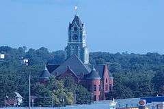
- Clinton County Courthouse, constructed from 1892-1897 by architects Stanley Mansfield and Josiah Rice in Romanesque Revival style. Exterior walls are of red sandstone and granite and the tower is of copper which has weathered to a bright green color. Noted architect Claire Allen from Jackson, Michigan also worked on this building.[24]
- Clinton Public Library, financed by Andrew Carnegie and built 1903-1904 from the design of the Chicago architectural firm of Patton & Miller. Beaux Arts Neoclassica; style with a monumental entry with processional steps and flanking paired columns. Symmetry of design and borrowings of Greek and Roman inspired elements complete the composition. Exterior walls of cut and dressed limestone.
- Lafayette Lamb House (YWCA), constructed in 1877 by architect W.W. Sanborn and rebuilt in 1906. Originally built in the Second Empire style, the 1906 'modernization' converted it to more of the Georgian Revival style.
- City National Bank (First National Bank), designed by John Morrell & Son in the Neoclassical style and constructed in 1911-1912
- Howes Building, constructed in 1900 for Edward Madison Howes by architect Josiah Rice in Renaissance Revival style, featuring engaged pilasters with Ionic capitals. The exterior street facades of the building are of red face brick with decorative accents of red terracotta. The fourth floor added in 1905 by architect John Morrell.
- Ankeny Building, constructed in 1930, designed by Chicago architect Harold Holmes in "Moderne" or Art Deco style. The building street facades are clad with cream-colored terracotta panels. Upper story windows are steel and glass in a stylized "Chicago window" expression. The Clinton Herald Monday December 8, 1930 p. 8, The Clinton Herald Saturday December 13, 1930 p. 5, The Clinton Herald Monday December 15, 1930 p. 16, The Clinton Herald Tuesday December 30, 1930 p. 5, The Clinton Herald Tuesday, January 6, 1931 p. 5, The Clinton Herald Thursday, January 8, 1931 p. 5, The Clinton Herald Thursday May 21, 1931 p. 11.
- Moeszinger-Marquis (Armstrong) Building, designed by Josiah Rice and constructed in 1891 by William Bentley for the Clinton Produce Company. In 1907 the Baldwin Bros. acquired the building for its wholesale hardware business, which in turn passed to its successor company, the Moeszinger-Marquis Hardware Company in 1912. In 1941 the building was acquired by R.W. Armstrong, who also conducted a wholesale hardware business from the premises.
- George M. Curtis Mansion (Women's Club), constructed in Queen Anne style in 1883-1884
- Castle Terrace Historic District, Originally platted in 1892. The project was a promotional effort to show developers, architects, and builders the application and products of the Curtis Company. The architectural design is highly eclectic, with Tudor Gothic the primary style utilized.
- Cherry Bank, Built 1870-1871, the Dr. A.L. Ankeny/Lindmeier/Cottral house is two stories high with walls of red brick with buff-colored brick used for quoins at the corners and for the window arches. A cornice, hip roof, and widow's walk cap the building
- Saint Irenaeus Church, was designed by W.W. Sanborn and was constructed from 1864-1871. The parish was found in 1852 in Lyons. It merged with the other four Clinton parishes in 1990 to form Jesus Christ, Prince of Peace Parish. The parish continued to use the St. Irenaeus Church building until 2008 when a new church was built near the Mill Creek Parkway.[25]
Notable people
- Felix Adler, "King of Clowns," Ringling Brothers Circus
- Matt Bentley, professional wrestler for Total Nonstop Action Wrestling
- Marquis Childs, Pulitzer Prize-winning columnist
- Muriel Frances Dana, child actress who appeared in silent hill films
- Robert Drouet, actor and playwright
- Judith Ellen Foster, lecturer, lawyer, temperance leader, early feminist
- Dale Gardner, NASA astronaut
- Artemus Gates, World War I hero, banker, Assistant Secretary of the Navy for Air during World War II
- Salvatore Giunta, Master Sergeant, US Army, first living recipient of the Medal of Honor since the Vietnam War.[26]
- Col. David Hilmers, former NASA Astronaut
- Robert Bruce Horsfall, artist
- Bernhard M. Jacobsen, Congressman
- William S. Jacobsen, Congressman
- David Johnson, running back, University of Northern Iowa and Arizona Cardinals
- David Joyce, lumber baron, industrialist
- W. H. D. Koerner, artist
- Chancy Lamb, lumber baron, industrialist
- Cynthia Leonard, suffragist, writer, mother of Lillian Russell, lived in Clinton
- Raymond J. Lynch, attorney, administrative law judge
- Larry Mac Duff, football player, head coach, and defensive coordinator
- James C. McGloon, Illinois state legislator
- Beth Marion, B-movie actress of the 1930s
- Peggy Moran, film actress, married film director Henry Koster
- George Nelson, former NASA astronaut
- Allen E. Paulson, businessman, developed the Gulfstream executive jet
- Ken Ploen, football player Rose Bowl Hall of Fame, Canadian Football Hall of Fame
- Lillian Russell, singer and actress in comic operas
- George Shadid, Illinois legislator[27]
- Duke Slater, football player College Football Hall of Fame who became a judge
- William Theisen, founder of Godfather's Pizza
- John Delbert Van Allen, dry goods merchant, department store owner
- Krista Voda, sportscaster, Fox Sports, SPEED Channel
- Colonel Russell W. Volckmann West Point graduate, leader of guerrilla resistance in the Philippines
- Captan Jack Wyly, Louisiana attorney and politician graduated from Clinton High School, ca. 1933
- LaMetta Wynn, first African-American elected as mayor of an Iowa municipality
- W.J. Young, lumber baron, industrialist
Notable businesses, past and present
- The Becker Seed Company located at 250 Main Ave began in 1856 by Fredrick Becker Sr. and operated by William August Becker until approx 1980.
- Gray & Lunt,[28][29] 1857, saw mills and lumber concerns
- C. Lamb (lumber),[28][29] c. 1857-1868, saw mills and lumber concerns
- W. J. Young and Company, W.J. Young, c. 1858-1892, saw mills and lumber concerns, sawmill said to be the largest in the world[30]
- Claussen, Thornburg & Smith, c. 1866, a small sash and door factory
- Curtis, Hemingway & Co., Charles F. Curtis and W.G. Hemingway, 1866-1868, manufacturing of sash and door woodwork
- Curtis Bros. & Co, George M. and Charles F. Curtis, 1866-1966, producer of doors, sashes, pre-glazed window units, blinds and general house finishings
- Lamb, Byng, & Co., Chancy Lamb, John Byng, Artemus Lamb,[28][29] c. 1868-1874, saw mills and lumber concerns
- Joyce & Smith, David Joyce, S.I. Smith, W.T. Joyce, c. 1869-1873, 1873-1895, 1895-?, major lumber interest, town of Lyons, and Clinton
- Mississippi River Logging Company, Friedrich Weyerhäuser, F.C.A. Denkmann, et al., 1870-1909, forestry land ownership, logging, timber transport[30]
- C. Lamb & Sons, Chancy Lamb, Artemus Lamb, Lafayette Lamb,[28][29] c. 1874-?, saw mills and lumber concerns
- Ellis & McCoy, 1880s, law firm
- Clinton Produce Company, c. 1891, a wholesale hardware business, in the current Moeszinger-Marquis (Armstrong) Building
- Baldwin Bros., c. 1907, a wholesale hardware business, in the current Moeszinger-Marquis (Armstrong) Building
- Moeszinger-Marquis Hardware Company, c. 1912, a wholesale hardware business, in the current Moeszinger-Marquis (Armstrong) Building
- Van Allen and Company Department Store, c. 1912–1914, in the Van Allen Building[31][32]
- One-In-Hand Tie Company, Joseph W. Less and brothers, c. 1930s-1950s, inventors and men's clothing manufacturers[33]
- R.W. Armstrong, c. 1941, a wholesale hardware business, in the current Moeszinger-Marquis (Armstrong) Building
- Archer Daniels Midland Corporation, present
- Clinton LumberKings, present, Class A minor league Midwest League team affiliated with the Seattle Mariners
- Clinton Herald, 1855–present, a daily newspaper now owned by Community Newspaper Holdings
References
- 1 2 "US Gazetteer files 2010". United States Census Bureau. Archived from the original on 2012-06-26. Retrieved 2012-05-11.
- 1 2 "American FactFinder". United States Census Bureau. Retrieved 2012-05-11.
- ↑ "Population Estimates". United States Census Bureau. Archived from the original on 2013-06-17. Retrieved 2013-05-23.
- ↑ "Find a County". National Association of Counties. Archived from the original on 2011-05-31. Retrieved 2011-06-07.
- ↑ Micropolitan Statistical Areas and Components, Office of Management and Budget, November 2007. Posted by the United States Census Bureau on 2008-06-24. Accessed 2009-02-04.
- 1 2 "City Data website". Scroll search. Retrieved 2010-11-22.
- ↑ Clinton, Iowa - Our Community
- ↑ The Clinton Herald, Monday, January 21, 1924 p.6
- ↑ The Clinton Morning News, Wednesday, October 15, 1885
- ↑ Clinton High School, Clinton, Iowa, USA
- ↑ "The Great Flood of 1965 At Clinton, Iowa: A Pictorial Review", KROS Radio News Department
- ↑ Iowa Great Places
- ↑ The Atlantic Monthly
- ↑ http://www.slashfood.com/2011/04/25/flavor-flav-ditches-his-fried-chicken-restaurant/
- ↑ "US Gazetteer files: 2010, 2000, and 1990". United States Census Bureau. 2011-02-12. Retrieved 2011-04-23.
- ↑ "US Army Corps of Engineers". Upper Mississippi River Navigation Charts. Retrieved 2010-12-02.
- ↑ "Annual Estimates of the Resident Population for Incorporated Places: April 1, 2010 to July 1, 2015". Retrieved July 2, 2016.
- ↑ "Census of Population and Housing". Census.gov. Archived from the original on May 11, 2015. Retrieved June 4, 2015.
- ↑ "American FactFinder". United States Census Bureau. Archived from the original on 2013-09-11. Retrieved 2008-01-31.
- ↑ "Bickelhaupt Arboretum website". Fourteen acres and forty years of experience,. Retrieved 2010-11-22.
- ↑ "Felix Adler Children's Discovery Center website". A Childs World. Retrieved 2010-11-22.
- ↑ "Mississippi River Trail". Retrieved 2010-12-02.
- ↑ "Clinton - Our Community - History". Clinton Area Chamber of Commerce. 2006. Retrieved 2012-11-29.
Ashford University 400 North Bluff Blvd., Clinton, IA 52732
- ↑ The wondrous works of Claire Allen, architect
- ↑ Smith, Jeniece. "St. Irenaeus: A legacy in danger". Clinton Herald (September 17, 2009). Retrieved 2010-09-30.
- ↑ Jacobs, Jennifer (September 12, 2010). "Iowan downplays Medal of Honor designation". The Des Moines Register. Archived from the original on September 13, 2010.
- ↑ 'Illinois Blue Book 1993-1994,' Biographical Sketch of George Shadid, pg. 111
- 1 2 3 4 _____ (1906) American Lumbermen: The Personal History and Public and Business Achievements of Eminent Lumbermen of the United States, Volume 2, Chicago:The American Lumberman, p. 21-24, see , accessed 30 June 2014.
- 1 2 3 4 P.B. Wolfe (1911) Wolfe's History of Clinton County, Iowa, v. 1, B. F. Bowen (publisher), p. 685, see , accessed 30 June 2014.
- 1 2 BJ Kleven (1946) The Mississippi River Logging Company, in Minnesota History (magazine), Sept, pp. 190-202, see , accessed 30 June 2014.
- ↑ Carolyn Pitts (July 1975). "National Register of Historic Places Inventory-Nomination: Van Allen and Son Department Store / John D. Van Allen and Son Dry-Goods Store" (pdf). National Park Service.Accompanying 3 photos, exterior and architectural details, undated. (830 KB)
- ↑ "Van Allen and Company Department Store". National Historic Landmark summary listing. National Park Service. Retrieved 2007-10-03.National Park Service (2007-01-23). "National Register Information System". National Register of Historic Places. National Park Service.
- ↑ Clinton County Historical Society (Author), 2003, Clinton Iowa (Images of America series), Arcadia Publishing (ISBN 0738523496), e.g. , accessed 27 February 2014.
Further reading
- The Clinton Daily Herald Saturday September 5, 1891 page 6
- The Biographical Record of Clinton County Iowa S.J. Clarke Publishing Company Chicago 1901
- Wolfe's History of Clinton County Iowa B.F. Bowen & Company Indianapolis, Indiana 1911
- History of Clinton County Iowa Clinton County Historical Society 1976
- The Clinton Herald, February 5, 2007, "Why Have Odor Complaints Declined?" by Scott T. Holland.
External links
| Wikimedia Commons has media related to Clinton, Iowa. |
| Wikisource has the text of a 1911 Encyclopædia Britannica article about Clinton, Iowa. |
- Official City Website
- Chamber of Commerce
- Clinton Regional Development Corporation
- Cultural and Tourist Attractions
- Riverview Cultural and Entertainment District
- Clinton's Open Forum Home
- City Data Comprehensive Statistical Data and more about Clinton, Iowa
- Liberty Square Brownfields Redevelopment Website
Municipalities and communities of Clinton County, Iowa, United States | ||
|---|---|---|
| Cities | ||
| Townships | ||
| Unincorporated communities | ||
| Footnotes | ‡This populated place also has portions in an adjacent county or counties | |