Woodruff County, Arkansas
| Woodruff County, Arkansas | |
|---|---|
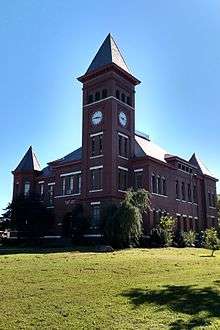 Woodruff County courthouse in Augusta | |
 Location in the U.S. state of Arkansas | |
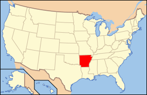 Arkansas's location in the U.S. | |
| Founded | November 26, 1862 |
| Named for | William E. Woodruff |
| Seat | Augusta |
| Largest city | Augusta |
| Area | |
| • Total | 594 sq mi (1,538 km2) |
| • Land | 587 sq mi (1,520 km2) |
| • Water | 7.2 sq mi (19 km2), 1.2% |
| Population (est.) | |
| • (2015) | 6,741 |
| • Density | 12/sq mi (5/km²) |
| Congressional district | 1st |
| Time zone | Central: UTC-6/-5 |
| Website |
woodruffcounty |
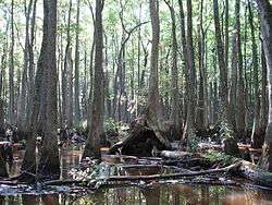
Woodruff County is located in the Arkansas Delta in the U.S. state of Arkansas. The county is named for William E. Woodruff, founder of the state's first newspaper, the Arkansas Gazette. Created as Arkansas's 54th county in 1862, Woodruff County is home to one incorporated town and four incorporated cities, including Augusta, the county seat. The county is also the site of numerous unincorporated communities and ghost towns. Occupying only 587 square miles (152,000 ha), Woodruff County is the 13th smallest county in Arkansas. As of the 2010 Census, the county's population is 7,260 people in 3,531 households.[1] Based on population, the county is the second-smallest county of the 75 in Arkansas.[2] Located in the Arkansas Delta, the county is largely flat with fertile soils. Historically covered in forest, bayous and swamps, the area was cleared for agriculture by early settlers. It is drained by the Cache River and the White River. Along the Cache River, the Cache River National Wildlife Refuge (NWR) runs north-south across the county, preserving bottomland forest, sloughs and wildlife habitat.
Although no Interstate highways are located in Woodruff County, two United States highways (U.S. Route 49 [US 49] and US 64) and twelve Arkansas state highways run in the county. Two Union Pacific Railroad lines cross the county.[3]
Geography

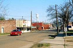
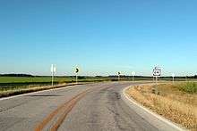
Bottom: Typical countryside in Woodruff County. This photo taken along Highway 64B north of Patterson.
The county is located in the Arkansas Delta, one of the six primary geographic regions of Arkansas. The Arkansas Delta is a subregion of the Mississippi Alluvial Plain, which is a flat area consisting of rich, fertile sediment deposits from the Mississippi River between Louisiana and Illinois. According to the U.S. Census Bureau, the county has a total area of 594 square miles (1,540 km2), of which 587 square miles (1,520 km2) is land and 7.2 square miles (19 km2) (1.2%) is water.[4] Major hydrologic features include the Cache River, which roughly bisects the county north-south, Bayou De View, which runs through eastern Woodruff County, and the White River, which serves as the county's western boundary.
Prior to settlement, Woodruff County was densely forested, with bayous, sloughs, and swamps crossing the land. Seeking to take advantage of the area's fertile soils, settlers cleared the land to better suit row crops. Although some swampland has been preserved in the Cache River NWR and some former farmland has undergone reforestation, the majority (56 percent) of the county remains in cultivation.[Note 1] Another large land use in Woodruff County is the Cache River NWR, owned by the United States Fish and Wildlife Service. Stretching approximately 90 miles (140 km) across adjacent counties, the NWR is listed as a Ramsar wetlands of international importance, and serves as a key wintering area for ducks and the largest contiguous tract of bottomland hardwood forest in North America. The NWR aggressively seeks willing property owners to sell land to add to the NWR's boundaries, adding 2,000 acres (810 ha) in 2015.[6]
The county is located approximately 75 miles (121 km) northeast of Little Rock and 81.3 miles (130.8 km) west of Memphis, Tennessee.[Note 2] Woodruff County is surrounded by five other Delta counties: Jackson County to the north, Cross County to the northeast, St. Francis County to the southeast, Monroe County to the south and Prairie County to the southwest. West of Woodruff County is White County, which is something of combination point for the Delta, Ozarks, and Central Arkansas.
Climate
Woodruff County has a humid subtropical climate (Köppen Cfa). Woodruff County experiences all four seasons, although summers can be extremely hot and humid and winters are mild with little snow. July is the hottest month of the year, with an average high of 93 °F (33.9 °C) and an average low of 70 °F (21.1 °C). Temperatures above 100 °F (38 °C) are not uncommon. January is the coldest month with an average high of 49 °F (9.4 °C) and an average low of 27 °F (−2.8 °C). The highest temperature was 112 °F (44.4 °C), recorded in 1936 and 1972. The lowest temperature recorded was −11 °F (−24 °C), on January 8, 1942.
| Climate data for Augusta Climate Data | |||||||||||||
|---|---|---|---|---|---|---|---|---|---|---|---|---|---|
| Month | Jan | Feb | Mar | Apr | May | Jun | Jul | Aug | Sep | Oct | Nov | Dec | Year |
| Record high °F (°C) | 87 (31) |
85 (29) |
90 (32) |
97 (36) |
99 (37) |
109 (43) |
112 (44) |
112 (44) |
109 (43) |
98 (37) |
87 (31) |
81 (27) |
112 (44) |
| Average high °F (°C) | 49 (9) |
54 (12) |
63 (17) |
73 (23) |
81 (27) |
89 (32) |
93 (34) |
92 (33) |
85 (29) |
74 (23) |
62 (17) |
51 (11) |
72.2 (22.3) |
| Average low °F (°C) | 27 (−3) |
31 (−1) |
39 (4) |
48 (9) |
58 (14) |
67 (19) |
70 (21) |
69 (21) |
60 (16) |
48 (9) |
39 (4) |
30 (−1) |
48.8 (9.3) |
| Record low °F (°C) | −11 (−24) |
−10 (−23) |
9 (−13) |
24 (−4) |
36 (2) |
44 (7) |
52 (11) |
48 (9) |
34 (1) |
24 (−4) |
11 (−12) |
−4 (−20) |
−11 (−24) |
| Average precipitation inches (mm) | 3.6 (91) |
3.8 (97) |
4.8 (122) |
5.0 (127) |
5.5 (140) |
2.9 (74) |
3.7 (94) |
2.7 (69) |
3.4 (86) |
4.7 (119) |
5.2 (132) |
5.0 (127) |
50.3 (1,278) |
| Average snowfall inches (cm) | 0.8 (2) |
1.0 (2.5) |
0.1 (0.3) |
0 (0) |
0 (0) |
0 (0) |
0 (0) |
0 (0) |
0 (0) |
0 (0) |
0 (0) |
0.1 (0.3) |
2.0 (5.1) |
| Source #1: The Weather Channel[8] | |||||||||||||
| Source #2: Weather Database[9] | |||||||||||||
Communities
Four incorporated cities and one incorporated towns are located within the county. The largest city and county seat, Augusta, is located in the western part of the county near the White River and the White County border. Augusta's population in 2010 was 2,199—well below its peak of 3,496 at the 1980 Census. McCrory and Patterson are adjacent to each other, located near the county's center. Cotton Plant and Hunter are both located in the southern part of Woodruff County, with 2010 populations of 649 and 105, respectively.
Woodruff County has dozens of unincorporated communities and ghost towns within its borders. This is due to early settlers in Arkansas tending to cluster in small clusters rather than incorporated towns. For example, Fitzhugh and Gregory had post offices at some point in their history. Other communities are simply a few dwellings at a crossroads that have adopted a common place name over time. Some are officially listed as populated places by the United States Geological Survey, and others are listed as historic settlements.
Unincorporated communities
- Becton
- Dixie
- Fitzhugh
- Grays
- Gregory
- Hillemann
- Howell
- Little Dixie‡
- McClelland
- Morton
- New Augusta
- New Salem
- Pleasant Grove
- Pumpkin Bend
- Shady Grove
Historic communities
- Barson
- Bemis
- Bulltown
- Casey
- Cavell
- Colona
- Cow Mound
- Daggett
- DeView
- Flynn
- Four Forks
- Goodrich
- Kramer
- Maberry
- McGregor
- Morelock
- Negro Head Corner
- Overcup
- Penrose
- Quinlan
- Revel
- Riverside
- Simmons
- Sturdevant
- Taylorville
- Tip
- Union
- Wiville
Townships
Townships in Arkansas are the divisions of a county. Each township includes unincorporated areas; some may have incorporated cities or towns within part of their boundaries. Arkansas townships have limited purposes in modern times. However, the United States Census does list Arkansas population based on townships (sometimes referred to as "county subdivisions" or "minor civil divisions"). Townships are also of value for historical purposes in terms of genealogical research. Each town or city is within one or more townships in an Arkansas county based on census maps and publications. The townships of Woodruff County are listed below; listed in parentheses are the cities, towns, and/or census-designated places that are fully or partially inside the township. [10][11]
- Augusta (Augusta)
- Barnes
- Cache
- Caney (Hunter)
- Cotton Plant (Cotton Plant)
- Dent
- De View (McCrory, Patterson)
- Franks
- Freeman
- Garden
- Point
- Pumpkin Bend
- White River
Demographics
| Historical population | |||
|---|---|---|---|
| Census | Pop. | %± | |
| 1870 | 6,891 | — | |
| 1880 | 8,646 | 25.5% | |
| 1890 | 14,009 | 62.0% | |
| 1900 | 16,304 | 16.4% | |
| 1910 | 20,049 | 23.0% | |
| 1920 | 21,547 | 7.5% | |
| 1930 | 22,682 | 5.3% | |
| 1940 | 22,133 | −2.4% | |
| 1950 | 18,957 | −14.3% | |
| 1960 | 13,954 | −26.4% | |
| 1970 | 11,566 | −17.1% | |
| 1980 | 11,222 | −3.0% | |
| 1990 | 9,520 | −15.2% | |
| 2000 | 8,741 | −8.2% | |
| 2010 | 7,260 | −16.9% | |
| Est. 2015 | 6,741 | [12] | −7.1% |
| U.S. Decennial Census[13] 1790–1960[14] 1900–1990[15] 1990–2000[16] 2010–2015[1] | |||

As of the 2000 United States Census,[18] there were 8,741 people, 3,531 households, and 2,439 families residing in the county. The population density was 15 people per square mile (6/km²). There were 4,089 housing units at an average density of 7 per square mile (3/km²). The racial makeup of the county was 67.86% White, 30.75% Black or African American, 0.23% Native American, 0.07% Asian, 0.10% Pacific Islander, 0.17% from other races, and 0.81% from two or more races. 0.79% of the population were Hispanic or Latino of any race.
There were 3,531 households out of which 30.90% had children under the age of 18 living with them, 48.60% were married couples living together, 16.70% had a female householder with no husband present, and 30.90% were non-families. 28.20% of all households were made up of individuals and 14.20% had someone living alone who was 65 years of age or older. The average household size was 2.44 and the average family size was 2.97.
In the county the population was spread out with 26.00% under the age of 18, 8.40% from 18 to 24, 24.50% from 25 to 44, 24.40% from 45 to 64, and 16.70% who were 65 years of age or older. The median age was 38 years. For every 100 females there were 89.20 males. For every 100 females age 18 and over, there were 84.90 males.
The median income for a household in the county was $22,099, and the median income for a family was $27,824. Males had a median income of $24,051 versus $17,995 for females. The per capita income for the county was $13,269. About 21.70% of families and 27.00% of the population were below the poverty line, including 38.10% of those under age 18 and 27.00% of those age 65 or over.
Government
The county government is a constitutional body granted specific powers by the Constitution of Arkansas and the Arkansas Code. The quorum court is the legislative branch of the county government and controls all spending and revenue collection. Representatives are called justices of the peace and are elected from county districts every even-numbered year. The number of districts in a county vary from nine to fifteen, and district boundaries are drawn by the county election commission. The Woodruff County Quorum Court has nine members. Presiding over quorum court meetings is the county judge, who serves as the chief executive officer of the county. The county judge is elected at-large and does not vote in quorum court business, although capable of vetoing quorum court decisions.[19][20]
A portion of Woodruff County is represented in the Arkansas State Senate by the Republican Ronald R. Caldwell, a real estate businessman from Wynne in Cross County. In the Arkansas House of Representatives, the local member is Michael John Gray, a Democrat and a farmer from Augusta who also holds a law degree.
Infrastructure
Aviation
The Woodruff County Airport located along US 64 between Patterson and Augusta is the only public own/public use airport in the county. It is a general aviation airport, serving primarily agricultural (spraying) and recreational operations. For the twelve-month period ending June 30, 2014, the facility saw 5,500 general aviation operations.[21]
Major highways
-
 U.S. Highway 49
 -
 U.S. Highway 64
 -
 Highway 17
 -
 Highway 33
 -
 Highway 37
 -
 Highway 38
 -
 Highway 78
 -
 Highway 145
 -
 Highway 260
 -
 Highway 262
 -
 Highway 269
 -
 Highway 284
 -
 Highway 306
 -
 Highway 339
See also
 Arkansas portal
- National Register of Historic Places listings in Woodruff County, Arkansas
References
- Notes
- ↑ In 2014, 114 thousand acres of soybeans, 58.7 thousand acres of rice, 14.6 thousand acres of wheat, 17 thousand acres of corn and 7 thousand acres of sorghum were planted in Woodruff County.[5] Total acreage for those two crops is 211,600. Woodruff County is 594 square miles, which is 380,160 acres based on 640 acres per square mile. Acreage for the total crops (211,600) divided by acreage for the county (380,160) is 55.7 percent.
- ↑ Mileages from Woodruff County to Little Rock and Memphis are based on highway miles using county seat Augusta for Woodruff County.[7]
- References
- 1 2 "State & County QuickFacts". United States Census Bureau. Retrieved May 19, 2014.
- ↑ "Find a County". National Association of Counties. Retrieved 2011-06-07.
- ↑ General Highway Map - Woodruff County, Arkansas (PDF) (Map) (9/2/00 ed.). Arkansas State Highway and Transportation Department. Retrieved January 22, 2016.
- ↑ "2010 Census Gazetteer Files". United States Census Bureau. August 22, 2012. Retrieved August 27, 2015.
- ↑ "National Agricultural Statistics Service County Level Data". U.S. Department of Agriculture. 2014. Retrieved January 22, 2016.
- ↑ "Cache River National Wildlife Refuge" (PDF). National Wildlife Refuge Association. Retrieved January 23, 2016.
- ↑ "Google Maps (Search for Augusta, AR)". Google. Retrieved January 22, 2016.
- ↑ "Monthly Averages for Augusta, AR" (Table). The Weather Channel. Retrieved January 23, 2016.
- ↑ "Monthly Snowfall Averages for Augusta, AR" (Table). Weather Database. Retrieved January 23, 2016.
- ↑ 2011 Boundary and Annexation Survey (BAS): Woodruff County, AR (PDF) (Map). U. S. Census Bureau. Retrieved 2011-08-24.
- ↑ "Arkansas: 2010 Census Block Maps - County Subdivision". United States Census Bureau. Retrieved May 29, 2014.
- ↑ "County Totals Dataset: Population, Population Change and Estimated Components of Population Change: April 1, 2010 to July 1, 2015". Retrieved July 2, 2016.
- ↑ "U.S. Decennial Census". United States Census Bureau. Retrieved August 27, 2015.
- ↑ "Historical Census Browser". University of Virginia Library. Retrieved August 27, 2015.
- ↑ Forstall, Richard L., ed. (March 27, 1995). "Population of Counties by Decennial Census: 1900 to 1990". United States Census Bureau. Retrieved August 27, 2015.
- ↑ "Census 2000 PHC-T-4. Ranking Tables for Counties: 1990 and 2000" (PDF). United States Census Bureau. April 2, 2001. Retrieved August 27, 2015.
- ↑ Based on 2000 census data
- ↑ "American FactFinder". United States Census Bureau. Retrieved 2011-05-14.
- ↑ Teske, Steven (March 24, 2014). "Quorum Courts". Encyclopedia of Arkansas History and Culture. Butler Center for Arkansas Studies at the Central Arkansas Library System. Retrieved January 23, 2016.
- ↑ Goss, Kay C. (August 28, 2015). "Office of County Judge". Encyclopedia of Arkansas History and Culture. Butler Center for Arkansas Studies at the Central Arkansas Library System. Retrieved January 23, 2016.
- ↑ FAA Airport Master Record for M60 (Form 5010 PDF). Federal Aviation Administration. Accessed December 10, 2015.
 |
Jackson County | Cross County | | |
| White County | |
|||
| ||||
| | ||||
| Prairie County | Monroe County | St. Francis County |
Municipalities and communities of Woodruff County, Arkansas, United States | ||
|---|---|---|
| Cities | | |
| Town | ||
| Unincorporated communities |
| |
| Ghost town |
| |
| Footnotes | ‡This populated place also has portions in an adjacent county or counties | |

Coordinates: 35°11′42″N 91°13′17″W / 35.19500°N 91.22139°W