Crawford County, Arkansas
| Crawford County, Arkansas | |
|---|---|
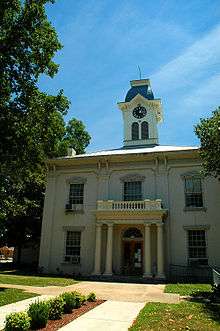 Crawford County Courthouse within the Van Buren Historic District in Van Buren | |
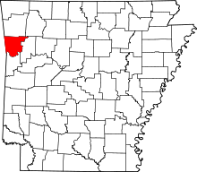 Location in the U.S. state of Arkansas | |
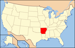 Arkansas's location in the U.S. | |
| Named for | William H. Crawford |
| Seat | Van Buren |
| Largest city | Van Buren |
| Area | |
| • Total | 604 sq mi (1,564 km2) |
| • Land | 593 sq mi (1,536 km2) |
| • Water | 11 sq mi (28 km2), 1.8% |
| Population (est.) | |
| • (2015) | 61,703 |
| • Density | 104/sq mi (40/km²) |
| Congressional districts | 3rd, 4th |
| Time zone | Central: UTC-6/-5 |
| Website |
www |
Crawford County is a county located in the Ozarks region of the U.S. state of Arkansas. As of the 2010 census, the population was 61,948, making it the twelfth-most populous of Arkansas's seventy-five counties.[1] The county seat and largest city is Van Buren.[2] Crawford County was formed on October 18, 1820 from the former Lovely County and Indian Territory, and was named for William H. Crawford, the United States Secretary of War in 1815.[3]
Located largely within the Ozarks, the southern border of the county is the Arkansas River, placing the extreme southern edge of the county in the Arkansas River Valley. The frontier county became an early crossroads, beginning with a California Gold Rush and developing into the Butterfield Overland Mail, Civil War trails and railroads such as the St. Louis and San Francisco Railway, the Little Rock and Fort Smith Railroad, and the St. Louis, Iron Mountain and Southern Railway. Today the county is home to the intersection of two major interstate highways, Interstate 40 (I-40) and I-49. Crawford County is part of the Fort Smith metropolitan area. As a dry county, alcohol sales are generally prohibited, though recent changes to county law provide for exemptions.
Geography
Crawford County is located in the northwest region of Arkansas. According to the U.S. Census Bureau, the county has a total area of 604 square miles (1,560 km2), of which 593 square miles (1,540 km2) is land and 11 square miles (28 km2) (1.8%) is water.[4]
Major highways
Crawford County is included in an area designated for a planned extension of I-49 into Arkansas. The final project will connect New Orleans, Louisiana, to Kansas City, Missouri, a large trucking corridor which is currently not served by an Interstate highway. The proposed highway would utilize portions of I-49 which currently runs north from Van Buren toward the Missouri state line passing through Benton County, home of Walmart. The corridor was listed as the number-one high-priority corridor by transportation officials in the Intermodal Surface Transportation Efficiency Act.
Adjacent counties
- Washington County (north)
- Madison County (northeast)
- Franklin County (east)
- Sebastian County (south)
- Le Flore County, Oklahoma (southwest)
- Sequoyah County, Oklahoma (west)
- Adair County, Oklahoma (northwest)
National protected area
- Ozark National Forest (part)
Demographics
| Historical population | |||
|---|---|---|---|
| Census | Pop. | %± | |
| 1830 | 2,440 | — | |
| 1840 | 4,266 | 74.8% | |
| 1850 | 7,960 | 86.6% | |
| 1860 | 7,850 | −1.4% | |
| 1870 | 8,957 | 14.1% | |
| 1880 | 14,740 | 64.6% | |
| 1890 | 21,714 | 47.3% | |
| 1900 | 21,270 | −2.0% | |
| 1910 | 23,942 | 12.6% | |
| 1920 | 25,739 | 7.5% | |
| 1930 | 22,549 | −12.4% | |
| 1940 | 23,920 | 6.1% | |
| 1950 | 22,727 | −5.0% | |
| 1960 | 21,318 | −6.2% | |
| 1970 | 25,677 | 20.4% | |
| 1980 | 36,892 | 43.7% | |
| 1990 | 42,493 | 15.2% | |
| 2000 | 53,247 | 25.3% | |
| 2010 | 61,948 | 16.3% | |
| Est. 2015 | 61,703 | [5] | −0.4% |
| U.S. Decennial Census[6] 1790–1960[7] 1900–1990[8] 1990–2000[9] 2010–2015[1] | |||
As of the 2000 United States Census,[10] there were 53,247 people, 19,702 households, and 15,150 families residing in the county. The population density was 35/km² (89/mi²). There were 21,315 housing units at an average density of 14/km² (36/mi²). The racial makeup of the county was 92.19% White, 0.87% Black or African American, 2.01% Native American, 1.19% Asian, 0.02% Pacific Islander, 1.48% from other races, and 2.24% from two or more races. 3.27% of the population were Hispanic or Latino of any race.
There were 19,702 households out of which 37.50% had children under the age of 18 living with them, 62.20% were married couples living together, 10.90% had a female householder with no husband present, and 23.10% were non-families. 20.00% of all households were made up of individuals and 8.20% had someone living alone who was 65 years of age or older. The average household size was 2.68 and the average family size was 3.07.
In the county the population was spread out with 28.20% under the age of 18, 8.40% from 18 to 24, 29.30% from 25 to 44, 22.80% from 45 to 64, and 11.30% who were 65 years of age or older. The median age was 35 years. For every 100 females there were 97.70 males. For every 100 females age 18 and over, there were 94.20 males.
The median income for a household in the county was $32,871, and the median income for a family was $36,741. Males had a median income of $29,581 versus $20,352 for females. The per capita income for the county was $15,015. About 10.90% of families and 14.20% of the population were below the poverty line, including 19.30% of those under age 18 and 13.70% of those age 65 or over.
Controversy
Thousands of self-claimed "Western Band of Cherokee" (or Arkansas Cherokees) fought for state and federal recognition as a political entity of Native Americans. Crawford County was historically part of the Cherokee Nation, which lost its tribal sovereignty status as a result of the U.S. Civil war in the 1860s. The Cherokee Nation was subsequently relocated to the west in the present-day state of Oklahoma.
Government
| Year | GOP | DNC | Others |
|---|---|---|---|
| 2016 | 74.3% 16,655 | 20.0% 4,476 | 5.7% 1,272 |
| 2012 | 73.6% 15,125 | 23.7% 4,872 | 2.7% 565 |
| 2008 | 71.5% 14,688 | 25.5% 5,238 | 3.0% 606 |
| 2004 | 65.6% 13,391 | 33.2% 6,764 | 1.2% 246 |
| 2000 | 61.3% 10,804 | 35.7% 6,288 | 3.0% 533 |
Communities
Cities
- Alma
- Cedarville
- Dyer
- Kibler
- Mountainburg
- Mulberry
- Van Buren (county seat)
Towns
- Chester
- Rudy Rudy USA small town situated along the Arkansas Missouri Railroad and the beautiful Frogg Bayau, a stream that flows an emerald green color most of the time. The Frog was named by an early explorer named Frooge. The area around Rudy was once known as a center for peach and apple production. With the influx of cedar trees, which blight peach and apple trees, production has changed to chicken and turkey farms as well as Gmao production of beef and sheep. The Rudy Store has revived as a merchant offering country breakfasts and hearty lunches,
Unincorporated community
Townships
Townships in Arkansas are the divisions of a county. Each township includes unincorporated areas; some may have incorporated cities or towns within part of their boundaries. Arkansas townships have limited purposes in modern times. However, the United States Census does list Arkansas population based on townships (sometimes referred to as "county subdivisions" or "minor civil divisions"). Townships are also of value for historical purposes in terms of genealogical research. Each town or city is within one or more townships in an Arkansas county based on census maps and publications. The townships of Crawford County are listed below; listed in parentheses are the cities, towns, and/or census-designated places that are fully or partially inside the township. [12][13]
- Alma (most of Alma)
- Bidville
- Cedar Creek
- Cedarville (Cedarville)
- Chester (Chester, small part of Mountainburg)
- Cove City
- Dean Springs (small part of Alma)
- Dora (part of Van Buren)
- Dyer (Dyer, small part of Alma)
- Jasper
- Kibler (most of Kibler)
- Lancaster
- Lees Creek
- Locke
- Mountainburg (most of Mountainburg)
- Mulberry (most of Mulberry)
- Oliver Springs
- Porter
- Rudy (Rudy, very small part of Alma)
- Uniontown
- Upper
- Van Buren (most of Van Buren, part of Kibler)
- Vine Prairie (part of Mulberry)
- Whitley
- Winfrey
See also
- List of lakes in Crawford County, Arkansas
- National Register of Historic Places listings in Crawford County, Arkansas
References
- 1 2 "State & County QuickFacts". United States Census Bureau. Retrieved May 20, 2014.
- ↑ "Find a County". National Association of Counties. Archived from the original on 2011-05-31. Retrieved 2011-06-07.
- ↑ Gannett, Henry (1905). The Origin of Certain Place Names in the United States. Govt. Print. Off. p. 95.
- ↑ "2010 Census Gazetteer Files". United States Census Bureau. August 22, 2012. Retrieved August 25, 2015.
- ↑ "County Totals Dataset: Population, Population Change and Estimated Components of Population Change: April 1, 2010 to July 1, 2015". Retrieved July 2, 2016.
- ↑ "U.S. Decennial Census". United States Census Bureau. Archived from the original on May 11, 2015. Retrieved August 25, 2015.
- ↑ "Historical Census Browser". University of Virginia Library. Retrieved August 25, 2015.
- ↑ Forstall, Richard L., ed. (March 27, 1995). "Population of Counties by Decennial Census: 1900 to 1990". United States Census Bureau. Retrieved August 25, 2015.
- ↑ "Census 2000 PHC-T-4. Ranking Tables for Counties: 1990 and 2000" (PDF). United States Census Bureau. April 2, 2001. Retrieved August 25, 2015.
- ↑ "American FactFinder". United States Census Bureau. Archived from the original on 2013-09-11. Retrieved 2011-05-14.
- ↑ "Dave Leip's Atlas of U.S. Presidential Elections". Retrieved November 18, 2016.
- ↑ 2011 Boundary and Annexation Survey (BAS): Crawford County, AR (PDF) (Map). U. S. Census Bureau. Retrieved 2011-08-25.
- ↑ "Arkansas: 2010 Census Block Maps - County Subdivision". United States Census Bureau. Retrieved May 27, 2014.
External links
 |
Adair County, Oklahoma | Washington County | Madison County | |
| Sequoyah County, Oklahoma | |
Franklin County | ||
| ||||
| | ||||
| Le Flore County, Oklahoma | Sebastian County |
Municipalities and communities of Crawford County, Arkansas, United States | ||
|---|---|---|
| Cities | | |
| Towns | ||
| Unincorporated communities | ||

Coordinates: 35°34′N 94°15′W / 35.567°N 94.250°W