Boone County, Arkansas
| Boone County, Arkansas | |
|---|---|
|
Boone County Courthouse | |
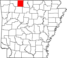 Location in the U.S. state of Arkansas | |
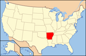 Arkansas's location in the U.S. | |
| Founded | April 9, 1869 |
| Seat | Harrison |
| Largest city | Harrison |
| Area | |
| • Total | 602 sq mi (1,559 km2) |
| • Land | 590 sq mi (1,528 km2) |
| • Water | 12 sq mi (31 km2), 1.9% |
| Population (est.) | |
| • (2015) | 37,222 |
| • Density | 63/sq mi (24/km²) |
| Congressional district | 3rd |
| Time zone | Central: UTC-6/-5 |
| Website |
www |
_001.jpg)
Boone County is a county located in the U.S. state of Arkansas. As of the 2010 census, the population was 36,903.[1] The county seat is Harrison.[2] It is Arkansas's 62nd county, formed on April 9, 1869.
Boone County is part of the Harrison, AR Micropolitan Statistical Area.
History
Boone County was formed from the eastern portion of Carroll County. Contrary to popular belief, it was not named for frontiersman Daniel Boone. It was originally called Boon, since the residents believed it would be a "boon" to all who settled there. The "e" was added to the name later.
Geography
According to the U.S. Census Bureau, the county has a total area of 602 square miles (1,560 km2), of which 590 sq mi (1,500 km2) is land and 12 sq mi (31 km2) (1.9%) is water.[3] The county is located in the northwest portion of the state, and borders Missouri to the north.
The county lies entirely within the Ozark Mountains. Rolling hills characterize the topography, with the more rugged Boston Mountains lying just to the south. Isolated peaks of the Boston Mountain range are found in the south, including Boat Mountain, Pilot's Knob, and Gaither Mountain. Portions of Bull Shoals Lake and Table Rock Lake lie in the northeast and northwest corners, respectively. The Corps of Engineers operates and maintains popular campsites on the lakes at Lead Hill and Cricket Creek. Crooked Creek, popular with bass fishermen, winds through the county from south to east.
Major highways
Adjacent counties
- Taney County, Missouri (north)
- Marion County (east)
- Searcy County (southeast)
- Newton County (south)
- Carroll County (west)
Demographics
| Historical population | |||
|---|---|---|---|
| Census | Pop. | %± | |
| 1870 | 7,032 | — | |
| 1880 | 12,146 | 72.7% | |
| 1890 | 15,816 | 30.2% | |
| 1900 | 16,396 | 3.7% | |
| 1910 | 14,318 | −12.7% | |
| 1920 | 16,098 | 12.4% | |
| 1930 | 14,937 | −7.2% | |
| 1940 | 15,860 | 6.2% | |
| 1950 | 16,260 | 2.5% | |
| 1960 | 16,116 | −0.9% | |
| 1970 | 19,073 | 18.3% | |
| 1980 | 26,067 | 36.7% | |
| 1990 | 28,297 | 8.6% | |
| 2000 | 33,948 | 20.0% | |
| 2010 | 36,903 | 8.7% | |
| Est. 2015 | 37,222 | [4] | 0.9% |
| U.S. Decennial Census[5] 1790–1960[6] 1900–1990[7] 1990–2000[8] 2010–2015[1] | |||

As of the 2000 United States Census,[10] there were 33,948 people, 13,851 households, and 9,861 families residing in the county. The population density was 57 people per square mile (22/km²). There were 15,426 housing units at an average density of 26 per square mile (10/km²). The racial makeup of the county was 97.60% White, 0.11% Black or African American, 0.71% Native American, 0.32% Asian, 0.02% Pacific Islander, 0.34% from other races, and 0.90% from two or more races. 1.06% of the population were Hispanic or Latino of any race.
There were 13,851 households out of which 30.70% had children under the age of 18 living with them, 59.50% were married couples living together, 8.80% had a female householder with no husband present, and 28.80% were non-families. 25.60% of all households were made up of individuals and 11.20% had someone living alone who was 65 years of age or older. The average household size was 2.41 and the average family size was 2.88.
In the county the population was spread out with 23.90% under the age of 18, 8.20% from 18 to 24, 26.50% from 25 to 44, 24.70% from 45 to 64, and 16.70% who were 65 years of age or older. The median age was 39 years. For every 100 females there were 93.10 males. For every 100 females age 18 and over, there were 89.70 males.
The median income for a household in the county was $29,988, and the median income for a family was $34,974. Males had a median income of $27,114 versus $19,229 for females. The per capita income for the county was $16,175. About 10.70% of families and 14.80% of the population were below the poverty line, including 19.00% of those under age 18 and 12.90% of those age 65 or over.
Education
Public school districts
Higher education
Government
| Year | GOP | DNC | Others |
|---|---|---|---|
| 2016 | 75.9% 12,235 | 18.2% 2,926 | 5.9% 950 |
| 2012 | 72.5% 11,143 | 24.5% 3,762 | 3.0% 458 |
| 2008 | 68.3% 10,575 | 28.7% 4,435 | 3.0% 464 |
| 2004 | 66.3% 9,793 | 31.4% 4,640 | 2.3% 344 |
| 2000 | 62.8% 8,569 | 33.0% 4,493 | 4.2% 573 |
Communities
Cities
- Diamond City
- Harrison (county seat)
Towns
Unincorporated communities
Historic communities
- Elixir was a town in the vicinity of many springs. It was nearby present day Bergman. Heavy rains flooded the town in 1883, which was a major factor in its decline by 1892. In the 1880s, both Lead Hill and Elixir were expecting a railroad but none materialized. This also helped the town's decline. Although the town is gone, the township of Elixir remains and currently contains Bergman.[12]
- Keener was a town around one mile south of present-day Bergman. Keener was strong in the 1880s and had a population of about 1,000 people. But, Keener began to decline fast by 1892.[12]
Townships

Townships in Arkansas are the divisions of a county. Each township includes unincorporated areas; some may have incorporated cities or towns within part of their boundaries. Arkansas townships have limited purposes in modern times. However, the United States Census does list Arkansas population based on townships (sometimes referred to as "county subdivisions" or "minor civil divisions"). Townships are also of value for historical purposes in terms of genealogical research. Each town or city is within one or more townships in an Arkansas county based on census maps and publications. The townships of Boone County are listed below; listed in parentheses are the cities, towns, and/or census-designated places that are fully or partially inside the township.[13][14]
Former townships include Bear Creek, Crooked Creek, Elmwood, Harrison, Washington, and Young.
See also
- List of lakes in Boone County, Arkansas
- National Register of Historic Places listings in Boone County, Arkansas
- Ron McNair, state representative for Boone and Carroll counties since 2015
References
- 1 2 "State & County QuickFacts". United States Census Bureau. Retrieved May 19, 2014.
- ↑ "Find a County". National Association of Counties. Archived from the original on 2011-05-31. Retrieved 2011-06-07.
- ↑ "2010 Census Gazetteer Files". United States Census Bureau. August 22, 2012. Retrieved August 25, 2015.
- ↑ "County Totals Dataset: Population, Population Change and Estimated Components of Population Change: April 1, 2010 to July 1, 2015". Retrieved July 2, 2016.
- ↑ "U.S. Decennial Census". United States Census Bureau. Archived from the original on May 11, 2015. Retrieved August 25, 2015.
- ↑ "Historical Census Browser". University of Virginia Library. Retrieved August 25, 2015.
- ↑ Forstall, Richard L., ed. (March 27, 1995). "Population of Counties by Decennial Census: 1900 to 1990". United States Census Bureau. Retrieved August 25, 2015.
- ↑ "Census 2000 PHC-T-4. Ranking Tables for Counties: 1990 and 2000" (PDF). United States Census Bureau. April 2, 2001. Retrieved August 25, 2015.
- ↑ Based on 2000 census data
- ↑ "American FactFinder". United States Census Bureau. Archived from the original on 2013-09-11. Retrieved 2011-05-14.
- ↑ "Dave Leip's Atlas of U.S. Presidential Elections". Retrieved November 18, 2016.
- 1 2 Butler, Kent (April 1995). Bergman - A Backward Look.
- ↑ 2011 Boundary and Annexation Survey (BAS): Boone County, AR (PDF) (Map). U. S. Census Bureau. Retrieved 2011-06-27.
- ↑ "Arkansas: 2010 Census Block Maps - County Subdivision". United States Census Bureau. Retrieved June 28, 2014.
- ↑ "County Subdivisions: Arkansas" (TXT). Census 2010 U.S. Gazetteer Files. United States Census Bureau.
- ↑ "Census 2010 U.S. Gazetteer Files". United States Census Bureau.
External links
- County government site
- Unofficial/Community guide site
- County Ordinances
- genealogy information pages at USGenWeb
- Map of Boone County (U. S. Census Bureau)
- Map of Boone County from Encyclopedia of Arkansas
- Boone County entry in the Encyclopedia of Arkansas
- Boone County Historical and Railroad Society, Inc.
- Boone County School District Reference Map (U. S. Census Bureau, 2010)
 |
Taney County, Missouri | | ||
| Carroll County | |
Marion County | ||
| ||||
| | ||||
| Newton County | Searcy County |
Municipalities and communities of Boone County, Arkansas, United States | ||
|---|---|---|
| Cities | | |
| Towns | ||
| Townships | ||
| Unincorporated communities | ||
| Ghost town | ||
| Footnotes | ‡This populated place also has portions in an adjacent county or counties | |
Coordinates: 36°18′22″N 93°05′38″W / 36.30611°N 93.09389°W