Bentonville, Arkansas
| Bentonville, Arkansas | |
|---|---|
| City | |
|
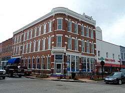
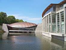
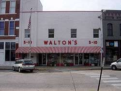
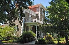
Clockwise, from top: Downtown Bentonville, Benton County Courthouse, Sam Walton's original Walton's Five and Dime store, Crystal Bridges Museum of American Art, and the Confederate Soldier Monument | |
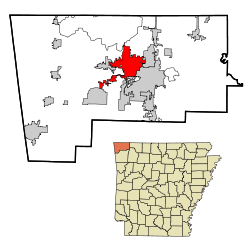 Location in Benton County and the state of Arkansas | |
| Coordinates: 36°22′0″N 94°12′48″W / 36.36667°N 94.21333°WCoordinates: 36°22′0″N 94°12′48″W / 36.36667°N 94.21333°W | |
| Country | United States |
| State | Arkansas |
| County | Benton |
| Incorporated | April 3, 1873 |
| Named for |
Originally Osage Indians Thomas Hart Benton |
| Government | |
| • Mayor | Bob McCaslin[1] |
| Area | |
| • Total | 31.5 sq mi (81.6 km2) |
| • Land | 31.3 sq mi (81.0 km2) |
| • Water | 0.2 sq mi (0.5 km2) |
| Elevation | 1,296 ft (395 m) |
| Population (2013 census estimate) | |
| • Total | 40,167 |
| • Density | 1,224/sq mi (472.4/km2) |
| Time zone | Central (CST) (UTC-6) |
| • Summer (DST) | CDT (UTC-5) |
| ZIP codes | 72712, 72716 |
| Area code(s) | 479 |
| FIPS code | 05-05320 |
| GNIS feature ID | 0076305 |
| Website |
www |

Bentonville is the tenth-largest city in Arkansas and the county seat of Benton County.[2] The city is centrally located in the county with Rogers adjacent to the east. The city is the headquarters of Walmart, which is the world's largest retailer.[3] Originally named Osage after the Osage Indians who hunted in the area when white settlers first moved to the area in 1837,[4] the community was renamed to Bentonville in 1843 in honor of Missouri politician Thomas Hart Benton and was first incorporated on April 3, 1873.[4][5] It is one of the four main cities in the four-county Northwest Arkansas Metropolitan Statistical Area, which is ranked 109th in terms of population in the United States with 463,204 in 2010 according to the United States Census Bureau. The city itself had a population of 35,301 at the 2010 Census,[6] with an estimated population of 40,167 in 2013.[7]
Bentonville is the location of the Walmart Home Office, and the retailer is very visible within the city. The Walmart Visitor Center is located on the Bentonville town square in Sam Walton's original Walton's Five and Dime.[8] The home office includes fifteen buildings along Walton Boulevard (US 71B) in the west part of the city. Just north of downtown Bentonville is the Crystal Bridges Museum of American Art. Founded by Alice Walton in 2011, this museum contains many masterpieces from all eras of American art, including many works from Walton's private collection.[9] Across the square from the Walmart Visitor Center is the Benton County Courthouse, the center of the county government. Bentonville High School is located just west of Interstate 49/US Route 71 in central Bentonville.
History
Early history

The area now known as Bentonville's first known use by humans was as hunting grounds by the Osage Nation who lived in Missouri. The Osage would leave their settlements to hunt in present-day Benton County for months at a time before returning to their families. White settlers first inhabited the area around 1837 and named their settlement "Osage". By this time, the Osage had ceased using the area for hunting, and the white settlers began to establish farms. Upon establishment of Benton County on September 30, 1836, Osage was deemed a suitable site for the county seat, and the town square was established as the home of county government the following year. Osage was renamed Bentonville in honor of Thomas Hart Benton, a senator from Missouri who strongly supported Arkansas statehood.[10] The Osage post office was established on December 31, 1836, and renamed Bentonville on January 3, 1843.[11]
Early statehood and Civil War
Two years after Arkansas received statehood in 1836, thousands of Cherokee people from Georgia passed through Benton County as part of the Trail of Tears route to the Indian Territory in what is now Oklahoma. Although no Civil War battles were fought inside Bentonville, the city was occupied by both armies and saw almost all of its buildings burned, either by opposing armies or guerrilla outlaws. Bentonville was a staging point for the Confederate army prior to the Battle of Pea Ridge, fought about 12 miles (19 km) northeast of town, and the town saw a brief skirmish just prior to the battle. The city began to rebuild about a decade after incorporation on April 3, 1873, with many of these Reconstruction Era buildings today serving as the oldest structures in Bentonville.
After the war, the area established a vibrant apple industry, with Benton County becoming the leading apple producing county in the nation in 1901. In the 1920s and 1930s the county developed a reputation as a leader in poultry production, which the area still maintains today.[12]
Geography
According to the United States Census Bureau, the city has a total area of 31.5 square miles (81.6 km2), of which 31.3 square miles (81.0 km2) is land and 0.19 square miles (0.5 km2), or 0.67%, is water.[6]
Metropolitan area
The Fayetteville–Springdale–Rogers Metropolitan Area consists of three Arkansas counties: Benton, Madison, and Washington, and McDonald County, Missouri. The area had a population of 347,045 at the 2000 census which had increased to 463,204 by the 2010 Census (an increase of 33.47 per cent). The Metropolitan Statistical Area does not consist of the usual principal-city-with-suburbs morphology; instead Bentonville is bordered to the east by Rogers, the north by Bella Vista, and the west by Centerton. The Northwest Arkansas Regional Airport is located to the southwest of Bentonville and is used to connect all of the northwest Arkansas region to the rest of the nation. Over the past decade or more, Northwest Arkansas has been one of the fastest-growing regions in the south.
Climate
Bentonville lies in the humid subtropical climate zone (Köppen Cfa) with influence from the humid continental climate type. Bentonville experiences all four seasons and does receive cold air masses from the north, however some of the Arctic masses are blocked by the higher elevations of the Ozarks. July is the hottest month of the year, with an average high of 89 °F (32 °C) and an average low of 66 °F (19 °C). Temperatures above 100 °F (37.8 °C) are common, with recent temperatures during summer months staying above 100 degrees for several weeks at a time. January is the coldest month with an average high of 46 °F (8 °C) and an average low of 24 °F (−4 °C). The city's highest temperature was 114 °F (45.6 °C), recorded in 1954. The lowest temperature recorded was −16 °F (−26.7 °C), in 1996.
| Climate data for Bentonville, Arkansas (1981–2010 normals) | |||||||||||||
|---|---|---|---|---|---|---|---|---|---|---|---|---|---|
| Month | Jan | Feb | Mar | Apr | May | Jun | Jul | Aug | Sep | Oct | Nov | Dec | Year |
| Record high °F (°C) | 76 (24) |
86 (30) |
88 (31) |
96 (36) |
93 (34) |
103 (39) |
114 (46) |
107 (42) |
106 (41) |
95 (35) |
85 (29) |
78 (26) |
114 (46) |
| Average high °F (°C) | 46 (8) |
51 (11) |
59 (15) |
69 (21) |
76 (24) |
84 (29) |
89 (32) |
89 (32) |
82 (28) |
71 (22) |
59 (15) |
48 (9) |
68.6 (20.5) |
| Average low °F (°C) | 24 (−4) |
27 (−3) |
35 (2) |
44 (7) |
54 (12) |
62 (17) |
66 (19) |
65 (18) |
57 (14) |
45 (7) |
36 (2) |
26 (−3) |
45.1 (7.3) |
| Record low °F (°C) | −15 (−26) |
−16 (−27) |
−12 (−24) |
16 (−9) |
24 (−4) |
40 (4) |
45 (7) |
44 (7) |
30 (−1) |
18 (−8) |
5 (−15) |
−15 (−26) |
−16 (−27) |
| Average precipitation inches (mm) | 2.61 (66.3) |
2.77 (70.4) |
4.30 (109.2) |
4.27 (108.5) |
5.72 (145.3) |
4.79 (121.7) |
3.33 (84.6) |
3.35 (85.1) |
4.71 (119.6) |
3.59 (91.2) |
4.36 (110.7) |
3.41 (86.6) |
47.21 (1,199.1) |
| Source: The Weather Channel[13] | |||||||||||||
Demographics
| Historical population | |||
|---|---|---|---|
| Census | Pop. | %± | |
| 1880 | 696 | — | |
| 1890 | 1,677 | 140.9% | |
| 1900 | 1,843 | 9.9% | |
| 1910 | 1,956 | 6.1% | |
| 1920 | 2,313 | 18.3% | |
| 1930 | 2,203 | −4.8% | |
| 1940 | 2,359 | 7.1% | |
| 1950 | 2,942 | 24.7% | |
| 1960 | 3,649 | 24.0% | |
| 1970 | 5,508 | 50.9% | |
| 1980 | 8,756 | 59.0% | |
| 1990 | 11,257 | 28.6% | |
| 2000 | 19,730 | 75.3% | |
| 2010 | 35,301 | 78.9% | |
| Est. 2015 | 44,499 | [14] | 26.1% |
2014 Estimate[16] | |||
As of 2010 Bentonville had a population of 35,301. The racial and ethnic composition of the population was 77.0% non-Hispanic white, 2.4% non-Hispanic black, 1.2% Native American, 5.8% Asian Indian, 2.8% other Asian, 0.2% Pacific Islander, 3.9% from some other race and 2.5% from two or more races. 8.7% of the population was Hispanic or Latino of any race.[17]
As of the census[18] of 2000, there were 19,730 people, 7,458 households, and 5,265 families residing in the city. The city grew substantially in the 1990s; the 1990 population was 11,257 and the city is expected to reach 50,000 people by the year 2030. According to the US Census, Bentonville and surrounding communities in Benton County is second in growth for Arkansas and among the 100 fastest-growing counties in the United States.[19]
The population density was 928.9 people per square mile (358.7/km²). There were 7,924 housing units at an average density of 373.1 per square mile (144.0/km²). The racial makeup of the city was 90.92% White, 0.88% Black or African American, 1.33% Native American, 2.40% Asian, 0.04% Pacific Islander, 2.68% from other races, and 1.76% from two or more races. 6.07% of the population were Hispanic or Latino of any race.
The 2005 Special Census reported 24,837 Whites/non-Hispanic whites (86.8%), 2,428 Hispanics of any race (8.5%), 1,135 Asians (4.0%), and 510 Blacks/African Americans 1.8%. Bentonville is home to a significant large Hispanic immigrant community, consisting of Mexicans and nationalities from Central America such as El Salvador and Honduras, came to find blue-collar jobs in the area's booming economy during the 1990s and 2000s.
There were 7,458 households out of which 40.1% had children under the age of 18 living with them, 55.6% were married couples living together, 11.9% had a female householder with no husband present, and 29.4% are classified as non-families by the United States Census Bureau. 24.4% of all households were made up of individuals and 6.7% had someone living alone who was 65 years of age or older. The average household size was 2.59 and the average family size was 3.11.
Bentonville is a popular real estate destination for senior citizens and families with young children for quite some time, due to relative affordability, lower crime rates for a city its size and a social conservative culture known in Northwest Arkansas. Bentonville and Benton County is said to have the most registered Republican voters of the state.
In the city the population was spread out with 29.5% under the age of 18, 9.8% from 18 to 24, 34.2% from 25 to 44, 17.9% from 45 to 64, and 8.5% who were 65 years of age or older. The median age was 31 years. For every 100 females there were 93.6 males. For every 100 females age 18 and over, there were 91.3 males.
The median income for a household in the city was $39,936, and the median income for a family was $46,558. Males had a median income of $31,816 versus $23,761 for females. The per capita income for the city was $20,831. 10.3% of the population and 7.5% of families were below the poverty line. Out of the total people living in poverty, 13.7% are under the age of 18 and 10.9% are 65 or older.
Economy
| Rank | Employer |
|---|---|
| 1 | Wal-Mart Stores, Inc. |
| 2 | Northwest Health System |
| 3 | Mercy of Northwest Arkansas |
| 4 | Bentonville School District |
| 5 | Benton County, Arkansas |
| 6 | City of Bentonville |
| 7 | Northwest Arkansas Community College |
| 8 | Arvest Bank Group, Inc |
| 9 | Outdoor Cap Company |
| 10 | Community Publishers |
Region
The Northwest Arkansas economy was historically based upon agriculture and poultry. In recent decades, NWA has seen rapid growth and diversification of its economy based upon the three Fortune 500 companies based there, Walmart, Tyson Foods, and J.B. Hunt, while also seeing a growing University of Arkansas and cultural amenities sector. Although impacted by the Great Recession, NWA's economy fared better than most peer metropolitan areas, the state of Arkansas and the United States overall. Between 2007 and 2013, the region saw unemployment rates significantly below those of peer regions and the national average; while also seeing a 1% net growth of jobs. The NWA gross domestic product grew 7.0% over the aforementioned time period, and bankruptcies, building permits and per capita incomes are returning to pre-Recession rates.[21]
The professional, education and health care sectors of the Northwest Arkansas economy have been growing steadily since 2007. Between 2007 and 2013, the region has seen a growth of 8,300 jobs in the region, with 6,100 added in education and health professions and 4,300 jobs added in the leisure and hospitality jobs related to the region's cultural amenities.[21] The government and transportation sectors have remained relatively constant between 2007 and 2013, however the manufacturing sector has seen steady decline, mirroring national averages. The construction and real estate sectors saw large declines attributable to the poor housing market during the economic downturn.
City

Bentonville has been home to Walmart since Sam Walton purchased a store on the town square in 1950 and renamed it Walton's 5 & 10. The retailer continued a rapid growth, but Helen Walton wished to remain in Bentonville to raise the family, and thus by the time Walmart became the #1 Fortune 500 in 2002, it was still based in Bentonville. The impact from the Walmart Home Office is multiplied by the over 1100 prospective Walmart vendors who have established sales offices in the region.[22] The large number of satellite offices for companies of almost every industry means a large number of transplants from around the United States can be found in Bentonville.[23] This phenomenon impacts the culture of Bentonville in addition to the city's economy.
Culture, contemporary life, and points of interest
Bentonville's culture is a combination of a Southern city, small town, global business hub, and the surrounding Northwest Arkansas metro.
Bentonville shares many of the characteristics commonly given to Arkansas as a Southern state, yet it has also absorbed minor cultural influence from the Midwest and West. Located firmly in the Mid-South, Bentonville's culture is distinct and differs from the Delta portion of the state. Many of the city's first settlers came from Upper South states like Kentucky North Carolina and Tennessee, who found the Ozarks familiar to the Appalachian Mountains back home.[24] The uplands of Arkansas, including Northwest Arkansas, did not participate in large-scale plantation farming with slaves like the Arkansas delta, instead electing to settle in small clusters, relying largely on subsistence agriculture and hunting rather than the settlement patters common in the Midwest and Deep South. The "hillbilly" stereotype given to the Ozarks and Appalachians is largely a derivative of the difficult topography, tendency to settle in clusters, and mostly cashless self-sustaining economy found in those regions. Bentonville's large proportion of Southern Baptist and Methodist adherents does reflect a trend often associated with the Deep South.[25]
Due to Walmart's prominence in the city, Bentonville is also an international focal point for retail suppliers and other supporting businesses. According to the Bentonville-Bella Vista Chamber of Commerce, over 1,250 suppliers have offices in Northwest Arkansas in an attempt to secure or retain Walmart's business.[26] Symbolic of Bentonville's complex culture was a cricket game played between PepsiCo and Walmart, spectated by their respective chief executives Indra Nooyi and Doug McMillon, chronicled in a Wall Street Journal article describing the complex Bentonville culture.[27] The game was played on a baseball field in Bentonville not well suited for typical cricket, so the players adapted new rules. The city has a league with 18 teams and a host of fans, mostly derived from the thousands of Indian natives drawn to Bentonville by Walmart software and IT jobs. Mayor Bob McCaslin says the City currently has no plans to build a public cricket pitch.
From the Walmart Museum on the downtown square to the over a dozen buildings spread throughout the city, Walmart's Home Office has a presence throughout Bentonville. The Northwest Arkansas Regional Airport has direct commercial flights from many large destination cities not typical of airports its size due to the supplier community.[28] Bentonville High School has programs to assist the sizable transient student population, including international students, for those who have recently relocated to Bentonville.
Arts
Crystal Bridges Museum of American Art is a $450,000,000 museum of American Art designed by architect Moshe Safdie located within walking distance of downtown Bentonville.[29]
Other points of interest include:
- Bentonville Public Library
- Museum of Native American History
In 2009, Bentonville ranked No. 13 on Newsmax magazine's list of the "Top 25 Most Uniquely American Cities and Towns," a piece written by current CBS News travel editor Peter Greenberg. In determining his ranking, Greenberg cited the then-upcoming Crystal Bridges Museum, as well as sites such as Compton Gardens and the Civil War-era Peel Mansion Museum & Heritage Gardens.[30]
Historic districts and properties
Bentonville contains over 30 listings on the National Register of Historic Places (NRHP), the official federal list of districts, sites, buildings, structures, and objects deemed worthy of preservation.
The city contains two residential historic districts, the Third Street Historic District and West Central Avenue Historic District. Both districts contain historic residences notable for their architectural styles and contributions to the city's early history. Together, over 40 houses are listed as contributing properties. Preeminent individual residential listings within the historic districts include the Craig-Bryan House, Elliott House, James A. Rice House and the Rice House on "A" Street. Residential listing elsewhere in the city include the Peel Mansion Museum, Stroud House and Col. Young House.
Also included in the NRHP are historic public structures, such as the Benton County Courthouse, Benton County Jail, Bentonville High School, commercial structures such as the Benton County National Bank, Massey Hotel, Roy's Office Supply Building, and the Terry Block Building, and two cemeteries.
Parks and trail system
The Bentonville Parks and Recreation Department maintains eighteen parks and over 20 miles (32 km) of trails.

Over 300 acres (120 ha) of city parks throughout the city offer educational, recreational and outdoors opportunities to park visitors. The largest park surrounds Lake Bella Vista and includes a popular perimeter fitness trail and disc golf course.[31] Memorial park features the Melvin Ford Aquatic Center as well as baseball, basketball, tennis, volleyball, skateboard, softball and soccer facilities.[32] The four baseball fields at Merchants Baseball Park have hosted the Bentonville Youth Baseball League since its inception in 1954.[33] Park Springs Park was created in the 1890s following the discovery of two springs with purported healing powers. The Burns Arboretum/Nature Trail was added in 1996 and includes a State Champion tree.[34]
Trails in Bentonville vary from small fitness trails to long mountain bike trails to the regional Razorback Greenway depending upon topography, intended use and city planning. The Northwest Arkansas Razorback Regional Greenway, a 36-mile (58 km) primarily off-road mixed use trail connecting the Northwest Arkansas region, runs through Bentonville near Bentonville High School, the Walmart Home Office, and Crystal Bridges on its way to Lake Bella Vista to the north. The Crystal Bridges Trail is a 1 mile (1.6 km) trail between downtown Bentonville and the museum, built by the museum and donated to the city. Public art and sculptures line the trail, which passes through Compton Gardens on its way to the museum's southeast entrance. After passing by an overlook where trail users can view the museum from a bluff, the Crystal Bridges Trail connects to the museum's 3-mile (4.8 km) trail system.[35] The city also has several trails connecting main streets, parks and neighborhoods throughout the city.
Government and politics
Mayor–city council
Bentonville operates within the mayor-city council form of government. The mayor is elected by a city-wide election to serve as the Chief Executive Officer (CEO) of the city by presiding over all city council meetings, laws are enforced and taxpayer funds are spent prudently. Once elected, the mayor also allocates duties to city employees. Mayors serve four-year terms and can serve unlimited terms.[36]
The city council is the unicameral legislative body of the city, consisting of eight members. The council's duties include balancing the city's budget and passing ordinances. The body also controls the representatives of specialized city commissions underneath their jurisdiction. Members are elected at-large with no term limits and represent individual wards. Council members must live in the ward they represent.[37]
Education

Public elementary and secondary education is provided by Bentonville Public Schools leading to graduation at Bentonville High School or Bentonville West High School. Bentonville Adventist School, associated with the Seventh-day Adventist Church, provides education services for kindergarten through eighth grade.
Bentonville is home to the Northwest Arkansas Community College (NWACC), a public two-year college that provides students undergraduate, vocational, career and technical education courses.
The Bentonville Public Library System consists of one central library, located at 405 S. Main Street, which provides residents with access to print books, publications and multimedia content.
Infrastructure
Transportation
Major highways
The major through route in Bentonville is Interstate 49/US 71. This fully controlled access, four-lane expressway is a discontinuous piece of a route ultimately planned to connect Kansas City, Missouri to New Orleans, Louisiana. Formerly designated as Interstate 540 with the re-designation as Interstate 49 being granted by the U S Department of Transportation Federal Highway Administration on March 28, 2014,[38] the highway became the first freeway in the area when it was completed in the 1990s to relieve the former US 71 (now US 71B) of a much-increased demand of through travelers following the unanticipated and rapid growth of the Northwest Arkansas metro. Future plans for the I-49 corridor include completion of a freeway segment through between Fort Smith and Texarkana and completion of a Bella Vista Bypass to the north.
Bentonville has one major provider of public transportation, Ozark Regional Transit, which operates in Benton/Washington Counties and is a broad bus-based fixed-route regional transit system.
Water
The City of Bentonville owns and operates a municipal water system that provides services to industrial, commercial and residential customers. Drinking water is purchased and pumped from the Beaver Water District treatment plant in Lowell.[39] The city uses approximately 10 million US gallons (38 ML) of water per day on average.[40]
Notable people
- James Henderson Berry, U.S. senator and 14th governor of Arkansas
- Jim Dotson, Republican member of the Arkansas House of Representatives from Bentonville
- Dan Douglas, Republican member of the Arkansas House of Representatives from Bentonville
- Dan Folger, singer
- Doug McMillon, CEO of Walmart[41]
- Louise Thaden, aviation pioneer, holder of numerous aviation records, and the first woman to win the Bendix Trophy
- Dwight Tosh, Republican member of the Arkansas House of Representatives from Jonesboro; former state police officer, former resident of Bentonville[42]
- Karri Turner, actress on the adventure/drama television show JAG
- Jim Walton, the 10th-richest person in the world, known for being the youngest son of Sam Walton, the founder of Walmart[43]
See also
 Arkansas portal
References
- ↑ Mayor's Office website Archived May 30, 2008, at the Wayback Machine.
- ↑ "Find a County". National Association of Counties. Archived from the original on 2011-05-31. Retrieved 2011-06-07.
- ↑ Schaefer, Steve (May 22, 2012). "With Wal-Mart At 10-Year Highs, Some Shareholders Want Directors Shown The Door". Forbes. Retrieved May 31, 2012.
- 1 2 Fenno, Cheryl Barnwell (1978). The place names of Benton County, Arkansas (Dissertation). Fayetteville, Arkansas: University of Arkansas. p. 56.
- ↑ "Bentonville, Arkansas". Geographic Names Information System. United States Geological Survey. May 31, 2012. Retrieved May 31, 2012.
- 1 2 "Geographic Identifiers: 2010 Demographic Profile Data (G001): Bentonville city, Arkansas". U.S. Census Bureau, American Factfinder. Retrieved September 20, 2013.
- ↑ "Annual Estimates of the Resident Population: April 1, 2010 to July 1, 2012 (PEPANNRES): Arkansas". U.S. Census Bureau, American Factfinder. Retrieved September 20, 2013.
- ↑ "Renovated Walmart Visitor Center to Re-Open May 21". Bentonville, Arkansas: Digital Journal. April 29, 2011. Retrieved May 31, 2012.
- ↑ Vogel, Carol (June 16, 2011). "A Billionaire's Eye for Art Shapes Her Singular Museum". The New York Times. Retrieved May 31, 2012.
- ↑ "Benton County Fun Facts". Archived from the original on June 25, 2012. Retrieved May 31, 2012.
- ↑ Fenno, Cheryl Barnwell (1978). The place names of Benton County, Arkansas (Dissertation). Fayetteville, Arkansas: University of Arkansas. p. 244.
- ↑ "Community history from Bentonville-Bella Vista Chamber of Commerce". Archived from the original on July 18, 2011. Retrieved August 5, 2011.
- ↑ "Monthly Averages for Bentonville, AR" (Table). The Weather Channel. Retrieved May 31, 2012.
- ↑ "Annual Estimates of the Resident Population for Incorporated Places: April 1, 2010 to July 1, 2015". Retrieved July 2, 2016.
- ↑ "Census of Population and Housing". Census.gov. Archived from the original on May 11, 2015. Retrieved June 4, 2015.
- ↑ "Annual Estimates of the Resident Population for Incorporated Places: April 1, 2010 to July 1, 2014". Retrieved June 4, 2015.
- ↑ 2010 general profile of population or housing characteristics of Bentonville from the US census
- ↑ "American FactFinder". United States Census Bureau. Archived from the original on 2013-09-11. Retrieved 2008-01-31.
- ↑ http://www.census.gov/popest/counties/CO-EST2004-09.html
- ↑ "Bentonville's Largest Employers". Bentonville-Bella Vista Chamber of Commerce. 2014. Retrieved March 15, 2014.
- 1 2 "2013 State of the Northwest Arkansas Region Report" (PDF). University of Arkansas Sam Walton College of Business and the Northwest Arkansas Council. 2013. p. 9. Retrieved September 14, 2014.
- ↑ Hopper, Laura J. (October 2004). "Bentonville, Ark., Is Sam's Town". The Regional Economist. Federal Reserve Bank of St. Louis. Retrieved March 15, 2014.
- ↑ Disbrowe, Paula (October 6, 2012). "Is Bentonville The South's Next Cultural Mecca?". Southern Living. Retrieved September 14, 2014.
- ↑ Arnold et al 2002, p. 104.
- ↑ Lancaster, Guy (June 7, 2013). "Arkansas's Regional Identity". Retrieved August 18, 2013.
- ↑ "Wal-Mart influences continue to push rapid growth in Bentonville". The City Wire. March 19, 2014. Retrieved November 29, 2015.
- ↑ Nassauer, Sarah (December 8, 2015). "In Bentonville, Is It Cricket To Play on a Baseball Field? Players face a sticky wicket with 18 teams, no grounds; Wal-Mart vs. Pepsi". Wall Street Journal. p. A1, A12. Retrieved December 24, 2015.
- ↑ "Transportation". NWA Council. Retrieved November 29, 2015.
- ↑ The official homepage of the Crystal Bridges Museum of American Art
- ↑ Greenberg, Peter. "Newsmax Magazine Rates the Top 25 Most Uniquely American Cities And Towns". Retrieved 15 January 2014.
- ↑ "Bella Vista Lake". City of Bentonville. Retrieved December 6, 2014.
- ↑ "Memorial Park". City of Bentonville. Retrieved December 6, 2014.
- ↑ "Merchants Baseball Park". City of Bentonville. Retrieved December 6, 2014.
- ↑ "Park Springs Park". City of Bentonville. Retrieved December 6, 2014.
- ↑ "Trails". Crystal Bridges Museum of American Art. Retrieved December 6, 2014.
- ↑ "Form of Government". City of Bentonville. Retrieved January 9, 2016.
- ↑ "Bentonville, Arkansas City Council". City of Bentonville. Retrieved January 9, 2016.
- ↑ http://www.arkansashighways.com/forums/I-49-approval-north.pdf
- ↑ Pruna, Jocelyne (November 3, 2012). "Election Day Will Decide Two Positions for Beaver Water District". KFSM-TV. Retrieved January 13, 2013.
- ↑ "Production Data" (PDF). Beaver Water District. October 2015. Retrieved November 29, 2015.
- ↑ "About Wal-Mart CEO Doug McMillon". CNBC. Associated Press. 26 February 2015. Retrieved 28 February 2015.
- ↑ "Dwight Crandall Tosh". intelius.com. Retrieved April 3, 2015.
- ↑ "#20 Jim Walton". Forbes.
External links
| Wikivoyage has a travel guide for Bentonville. |
| Wikimedia Commons has media related to Bentonville, Arkansas. |
- Official website
- History of Bentonville's Jewish community (from the Institute of Southern Jewish Life)
- Encyclopedia of Arkansas History & Culture entry: Bentonville (Benton County)
- "Redistricting likely ahead for Arkansas", USA Today, Feb. 21, 2011
Municipalities and communities of Benton County, Arkansas, United States | ||
|---|---|---|
| Cities | 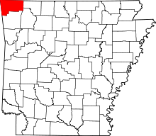 | |
| Towns | ||
| Townships | ||
| CDPs | ||
| Other communities |
| |
| Ghost town | ||
| Footnotes | ‡This populated place also has portions in an adjacent county or counties | |