Desha County, Arkansas
| Desha County, Arkansas | |
|---|---|
 Desha County courthouse in Arkansas City | |
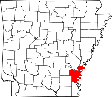 Location in the U.S. state of Arkansas | |
 Arkansas's location in the U.S. | |
| Founded | December 12, 1838 |
| Named for | Benjamin Desha |
| Seat | Arkansas City |
| Largest city | Dumas |
| Area | |
| • Total | 820 sq mi (2,124 km2) |
| • Land | 768 sq mi (1,989 km2) |
| • Water | 51 sq mi (132 km2), 6.3% |
| Population (est.) | |
| • (2015) | 11,965 |
| • Density | 17/sq mi (7/km²) |
| Congressional district | 1st |
| Time zone | Central: UTC-6/-5 |
| Website |
deshacounty |
Desha County /dəˈʃeɪ/ is a county located in the southeast part of the U.S. state of Arkansas. As of the 2010 census, the population was 13,008, making it the fifty-sixth most populous of Arkansas's seventy-five counties.[1] The county seat is Arkansas City.[2] Located within the Arkansas Delta, Desha County's rivers and fertile soils led to prosperity under the cotton-driven economy of plantation agriculture. Following mechanization on the farm, Desha County saw a demographic and economic transformation. Today, the county seeks to reverse its population and economic losses through better education for its workforce and tourism based on the cultural, historical and outdoor recreation amenities it offers to residents and tourists.[3]
History
Desha County was created by the Arkansas Legislature on December 12, 1838, consisting of the lands of Arkansas County separated from the county seat by the Arkansas River White River and land from Chicot County. The county was named for Captain Benjamin Desha, who fought in the War of 1812.[3][4]
Geography
According to the U.S. Census Bureau, the county has a total area of 820 square miles (2,100 km2), of which 768 square miles (1,990 km2) is land and 51 square miles (130 km2) (6.3%) is water.[5] Desha County is within the Arkansas Delta and is considered a member of the Southeast Arkansas region.
Major highways
 Future Interstate 69
 U.S. Highway 65
 U.S. Highway 165
 U.S. Highway 278
 Highway 1
 Highway 4
 Highway 138
Adjacent counties
- Arkansas County (north)
- Phillips County (northeast)
- Bolivar County, Mississippi (east)
- Chicot County (south)
- Drew County (southwest)
- Lincoln County (northwest)
National protected area
Demographics
| Historical population | |||
|---|---|---|---|
| Census | Pop. | %± | |
| 1840 | 1,598 | — | |
| 1850 | 2,911 | 82.2% | |
| 1860 | 6,459 | 121.9% | |
| 1870 | 6,125 | −5.2% | |
| 1880 | 8,973 | 46.5% | |
| 1890 | 10,324 | 15.1% | |
| 1900 | 11,511 | 11.5% | |
| 1910 | 15,274 | 32.7% | |
| 1920 | 20,297 | 32.9% | |
| 1930 | 21,814 | 7.5% | |
| 1940 | 27,160 | 24.5% | |
| 1950 | 25,155 | −7.4% | |
| 1960 | 20,770 | −17.4% | |
| 1970 | 18,761 | −9.7% | |
| 1980 | 19,760 | 5.3% | |
| 1990 | 16,798 | −15.0% | |
| 2000 | 15,341 | −8.7% | |
| 2010 | 13,008 | −15.2% | |
| Est. 2015 | 11,965 | [6] | −8.0% |
| U.S. Decennial Census[7] 1790–1960[8] 1900–1990[9] 1990–2000[10] 2010–2015[1] | |||
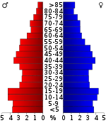
As of the 2000 United States Census,[12] there were 15,341 people, 5,922 households, and 4,192 families residing in the county. The population density was 20 people per square mile (8/km²). There were 6,663 housing units at an average density of 9 per square mile (3/km²). The racial makeup of the county was 50.50% White, 46.33% Black or African American, 0.35% Native American, 0.30% Asian, 0.03% Pacific Islander, 1.73% from other races, and 0.76% from two or more races. 3.16% of the population were Hispanic or Latino of any race.
There were 5,922 households out of which 34.60% had children under the age of 18 living with them, 46.50% were married couples living together, 19.90% had a female householder with no husband present, and 29.20% were non-families. 26.90% of all households were made up of individuals and 12.70% had someone living alone who was 65 years of age or older. The average household size was 2.57 and the average family size was 3.10.
In the county the population was spread out with 28.90% under the age of 18, 9.00% from 18 to 24, 25.20% from 25 to 44, 22.70% from 45 to 64, and 14.20% who were 65 years of age or older. The median age was 36 years. For every 100 females there were 87.60 males. For every 100 females age 18 and over, there were 82.90 males.
The median income for a household in the county was $24,121, and the median income for a family was $30,028. Males had a median income of $29,623 versus $18,913 for females. The per capita income for the county was $13,446. About 23.60% of families and 28.90% of the population were below the poverty line, including 39.60% of those under age 18 and 24.00% of those age 65 or over.
Government
| Year | GOP | DNC | Others |
|---|---|---|---|
| 2016 | 45.0% 1,915 | 52.4% 2,227 | 2.6% 110 |
| 2012 | 42.6% 1,807 | 55.5% 2,353 | 1.9% 80 |
| 2008 | 42.7% 1,999 | 54.9% 2,569 | 2.4% 110 |
| 2004 | 37.2% 1,729 | 61.4% 2,851 | 1.4% 67 |
| 2000 | 35.6% 1,603 | 61.8% 2,776 | 2.6% 116 |
Communities
Cities
Towns
- Arkansas City (county seat)
- Reed
- Tillar
Unincorporated areas
Historic community
Townships
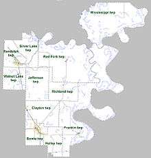
Townships in Arkansas are the divisions of a county. Each township includes unincorporated areas; some may have incorporated cities or towns within part of their boundaries. Arkansas townships have limited purposes in modern times. However, the United States Census does list Arkansas population based on townships (sometimes referred to as "county subdivisions" or "minor civil divisions"). Townships are also of value for historical purposes in terms of genealogical research. Each town or city is within one or more townships in an Arkansas county based on census maps and publications. The townships of Desha County are listed below; listed in parentheses are the cities, towns, and/or census-designated places that are fully or partially inside the township. [14][15]
- Bowie (most of McGehee)
- Clayton (Reed, Tillar, small part of McGehee)
- Franklin (Arkansas City)
- Halley (small part of McGehee)
- Jefferson
- Mississippi
- Randolph (Mitchellville, most of Dumas)
- Red Fork (Watson)
- Richland
- Silver Lake
- Walnut Lake
Notable people
- Garland Bayliss
- Ken Coon
- John "Kayo" Dottley
- Jim Hines
- John H. Johnson
- Major Jones
- Mark D. McElroy
- Doug Terry
- Barry Williamson
See also
- List of lakes in Desha County, Arkansas
- National Register of Historic Places listings in Desha County, Arkansas
References
- 1 2 "State & County QuickFacts". United States Census Bureau. Retrieved May 20, 2014.
- ↑ "Find a County". National Association of Counties. Retrieved 2011-06-07.
- 1 2 "Desha County". Encyclopedia of Arkansas History & Culture. The Central Arkansas Library System. 2009. Retrieved June 29, 2014.
- ↑ Gannett, Henry (1905). The Origin of Certain Place Names in the United States. Govt. Print. Off. p. 105.
- ↑ "2010 Census Gazetteer Files". United States Census Bureau. August 22, 2012. Retrieved August 26, 2015.
- ↑ "County Totals Dataset: Population, Population Change and Estimated Components of Population Change: April 1, 2010 to July 1, 2015". Retrieved July 2, 2016.
- ↑ "U.S. Decennial Census". United States Census Bureau. Retrieved August 26, 2015.
- ↑ "Historical Census Browser". University of Virginia Library. Retrieved August 26, 2015.
- ↑ Forstall, Richard L., ed. (March 27, 1995). "Population of Counties by Decennial Census: 1900 to 1990". United States Census Bureau. Retrieved August 26, 2015.
- ↑ "Census 2000 PHC-T-4. Ranking Tables for Counties: 1990 and 2000" (PDF). United States Census Bureau. April 2, 2001. Retrieved August 26, 2015.
- ↑ Based on 2000 census data
- ↑ "American FactFinder". United States Census Bureau. Retrieved 2011-05-14.
- ↑ "Dave Leip's Atlas of U.S. Presidential Elections". Retrieved November 18, 2016.
- ↑ 2011 Boundary and Annexation Survey (BAS): Desha County, AR (PDF) (Map). U. S. Census Bureau. Retrieved 2011-08-21.
- ↑ "Arkansas: 2010 Census Block Maps - County Subdivision". United States Census Bureau. Retrieved May 28, 2014.
| Wikimedia Commons has media related to Desha County, Arkansas. |
 |
Lincoln County | Arkansas County | Phillips County | |
| |
Bolivar County, Mississippi | |||
| ||||
| | ||||
| Drew County | Chicot County |
Municipalities and communities of Desha County, Arkansas, United States | ||
|---|---|---|
| Cities | | |
| Towns | ||
| Unincorporated communities | ||
| Ghost town | ||
| Footnotes | ‡This populated place also has portions in an adjacent county or counties | |

Coordinates: 33°45′28″N 91°17′14″W / 33.75778°N 91.28722°W