Little River County, Arkansas
| Little River County, Arkansas | |
|---|---|
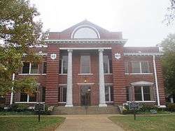 Little River County Courthouse in Ashdown | |
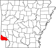 Location in the U.S. state of Arkansas | |
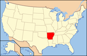 Arkansas's location in the U.S. | |
| Founded | March 5, 1867 |
| Named for | Little River[1] |
| Seat | Ashdown |
| Area | |
| • Total | 565 sq mi (1,463 km2) |
| • Land | 532 sq mi (1,378 km2) |
| • Water | 33 sq mi (85 km2), 5.8% |
| Population (est.) | |
| • (2015) | 12,472 |
| • Density | 25/sq mi (10/km²) |
| Congressional district | 4th |
| Time zone | Central: UTC-6/-5 |
| Website |
www |
Little River County is a county located in the U.S. state of Arkansas.As of the 2010 census, the population was 13,171.[2] The county seat is Ashdown.[3]
As of 1983 Little River County is no longer included in the Texarkana, TX-AR Metropolitan Statistical Area. Little River County, Arkansas, was added to the SMSA in 1973.
History
Little River County is Arkansas's 59th county, formed from Sevier County on March 5, 1867, and named for the Little River. The county is separated from all other surrounding counties in the state by water (a characteristic shared only with neighboring Miller County), with the Little River, Millwood Lake and the Red River forming the boundaries of the county within the state.
Little River County is also one of several dry counties within the state of Arkansas, prohibiting the sale of alcohol.
Geography
According to the U.S. Census Bureau, the county has a total area of 565 square miles (1,460 km2), of which 532 square miles (1,380 km2) is land and 33 square miles (85 km2) (5.8%) is water.[4] It is the third-smallest county in Arkansas by land area and fourth-smallest by total area.
Major highways
Adjacent counties
- Sevier County (north)
- Howard County (northeast)
- Hempstead County (east)
- Miller County (southeast)
- Bowie County, Texas (south)
- McCurtain County, Oklahoma (west)
Demographics
| Historical population | |||
|---|---|---|---|
| Census | Pop. | %± | |
| 1870 | 3,236 | — | |
| 1880 | 6,404 | 97.9% | |
| 1890 | 8,903 | 39.0% | |
| 1900 | 13,731 | 54.2% | |
| 1910 | 13,597 | −1.0% | |
| 1920 | 16,301 | 19.9% | |
| 1930 | 15,515 | −4.8% | |
| 1940 | 15,932 | 2.7% | |
| 1950 | 11,690 | −26.6% | |
| 1960 | 9,211 | −21.2% | |
| 1970 | 11,194 | 21.5% | |
| 1980 | 13,952 | 24.6% | |
| 1990 | 13,966 | 0.1% | |
| 2000 | 13,628 | −2.4% | |
| 2010 | 13,171 | −3.4% | |
| Est. 2015 | 12,472 | [5] | −5.3% |
| U.S. Decennial Census[6] 1790–1960[7] 1900–1990[8] 1990–2000[9] 2010–2015[2] | |||
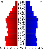
As of the 2000 United States Census,[11] there were 13,628 people, 5,465 households, and 3,912 families residing in the county. The population density was 26 people per square mile (10/km²). There were 6,435 housing units at an average density of 12 per square mile (5/km²). The racial makeup of the county was 74.52% White, 21.27% Black or African American, 1.45% Native American, 0.20% Asian, 0.03% Pacific Islander, 0.86% from other races, and 1.67% from two or more races. 1.72% of the population were Hispanic or Latino of any race.
There were 5,465 households out of which 31.40% had children under the age of 18 living with them, 55.60% were married couples living together, 12.30% had a female householder with no husband present, and 28.40% were non-families. 26.30% of all households were made up of individuals and 12.00% had someone living alone who was 65 years of age or older. The average household size was 2.46 and the average family size was 2.95.
In the county the population was spread out with 25.20% under the age of 18, 8.40% from 18 to 24, 25.70% from 25 to 44, 25.60% from 45 to 64, and 15.10% who were 65 years of age or older. The median age was 38 years. For every 100 females there were 94.70 males. For every 100 females age 18 and over, there were 90.30 males.
The median income for a household in the county was $29,417, and the median income for a family was $36,207. Males had a median income of $32,489 versus $18,435 for females. The per capita income for the county was $15,899. About 11.90% of families and 15.40% of the population were below the poverty line, including 18.80% of those under age 18 and 17.80% of those age 65 or over.
Communities
Cities
Towns
Census-designated place
Townships
Townships in Arkansas are the divisions of a county. Each township includes unincorporated areas; some may have incorporated cities or towns within part of their boundaries. Arkansas townships have limited purposes in modern times. However, the United States Census does list Arkansas population based on townships (sometimes referred to as "county subdivisions" or "minor civil divisions"). Townships are also of value for historical purposes in terms of genealogical research. Each town or city is within one or more townships in an Arkansas county based on census maps and publications. The townships of Little River County are listed below; listed in parentheses are the cities, towns, and/or census-designated places that are fully or partially inside the township. [12][13]
Notable people
- Marion H. Crank, Speaker of the Arkansas House of Representatives, 1963-1964; Democratic gubernatorial nominee, 1968; resided in Foreman, interred there at Holy Cross Cemetery[14]
- Jeff Davis (Arkansas governor), Democratic United States Senator from Arkansas and the 20th Governor of the U.S. state of Arkansas[15]
See also
- List of lakes in Little River County, Arkansas
- National Register of Historic Places listings in Little River County, Arkansas
- Ashdown School District
- Foreman School District
References
- ↑ Gannett, Henry (1905). The Origin of Certain Place Names in the United States. U.S. Government Printing Office. p. 188.
- 1 2 "State & County QuickFacts". United States Census Bureau. Retrieved May 23, 2014.
- ↑ "Find a County". National Association of Counties. Retrieved 2011-06-07.
- ↑ "2010 Census Gazetteer Files". United States Census Bureau. August 22, 2012. Retrieved August 27, 2015.
- ↑ "County Totals Dataset: Population, Population Change and Estimated Components of Population Change: April 1, 2010 to July 1, 2015". Retrieved July 2, 2016.
- ↑ "U.S. Decennial Census". United States Census Bureau. Retrieved August 27, 2015.
- ↑ "Historical Census Browser". University of Virginia Library. Retrieved August 27, 2015.
- ↑ Forstall, Richard L., ed. (March 27, 1995). "Population of Counties by Decennial Census: 1900 to 1990". United States Census Bureau. Retrieved August 27, 2015.
- ↑ "Census 2000 PHC-T-4. Ranking Tables for Counties: 1990 and 2000" (PDF). United States Census Bureau. April 2, 2001. Retrieved August 27, 2015.
- ↑ Based on 2000 census data
- ↑ "American FactFinder". United States Census Bureau. Retrieved 2011-05-14.
- ↑ 2011 Boundary and Annexation Survey (BAS): Little River County, AR (PDF) (Map). U. S. Census Bureau. Retrieved 2011-08-24.
- ↑ "Arkansas: 2010 Census Block Maps - County Subdivision". United States Census Bureau. Retrieved May 29, 2014.
- ↑ "Crank, Marion". ourcampaigns.com. Retrieved September 7, 2013.
- ↑ "Arkansas Governor Jefferson Davis". National Governors Association. Retrieved August 17, 2012.
 |
Sevier County | | ||
| McCurtain County, Oklahoma | |
Hempstead County | ||
| ||||
| | ||||
| Bowie County, Texas | Miller County |
Municipalities and communities of Little River County, Arkansas, United States | ||
|---|---|---|
| Cities | | |
| Towns | ||
| CDP | ||
| Unincorporated communities | ||
Coordinates: 33°41′53″N 94°13′18″W / 33.69806°N 94.22167°W