Wesley, Indiana
| Wesley | |
|---|---|
| Unincorporated community | |
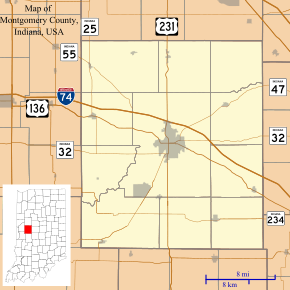 Wesley Location in Montgomery County | |
| Coordinates: 40°04′04″N 87°00′24″W / 40.06778°N 87.00667°WCoordinates: 40°04′04″N 87°00′24″W / 40.06778°N 87.00667°W | |
| Country | United States |
| State | Indiana |
| County | Montgomery |
| Township | Wayne |
| Elevation[1] | 807 ft (246 m) |
| ZIP code | 47933 |
| FIPS code | 18-82286[2] |
| GNIS feature ID | 445688 |
Wesley is an unincorporated community in Wayne Township, Montgomery County, Indiana.
Geography
Wesley is located at 40°04′04″N 87°00′24″W / 40.06778°N 87.00667°W.
Local History
This unincorporated town was home to a train station[3] (now gone) and a church school called Wesley Academy (building still there, no school being held any longer). The Wesley Cemetery is still being used today and the Wesley Chapel Church building that was built in 1901 is still standing today and will conduct worship services from time to time.
The Wesley Chapel building still has most of the original stained glass windows installed along with many of the original fixtures still being used in the building for church services being held there today.
The main section of Wesley is located on the northern part of Section 20, Wayne Township, Montgomery County, Indiana on the south side of highway U.S 136. Today, 2015, the village is dominated by the old Wesley Academy School building and the Wesley Church building. A storage company sits to the west of the church and a butcher shop and meat locker to the east and several homes.
The Big Four Railroad was built to the west and south of Wesley in 1869 and 1.2 miles west of the village along the highway a flag stop was installed called Wesley Flag Station. It was at the station where a post office was set up, in addition to a grocery and cabinet shop. A wind mill pumped water to supply the locomotives and a toll booth was installed here when the road was graveled in the 1870.
References
- ↑ "US Board on Geographic Names". United States Geological Survey. 2007-10-25. Retrieved 2008-01-31.
- ↑ "American FactFinder". United States Census Bureau. Retrieved 2008-01-31.
- ↑ Beckwith, Hiram Williams & Kennedy, P. S. (1881). History of Montgomery County, Together with Historic Notes on the Wabash Valley. H. H. Hill and N. Iddings. p. 591.
Municipalities and communities of Montgomery County, Indiana, United States | ||
|---|---|---|
| City | ||
| Towns | ||
| Townships | ||
| CDP | ||
| Other unincorporated communities |
| |