Union Township, Montgomery County, Indiana
| Union Township | |
|---|---|
| Township | |
|
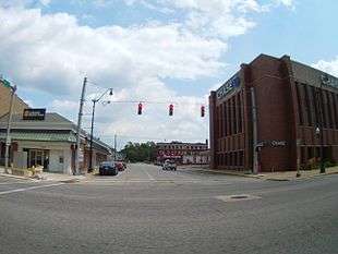
Downtown Crawfordsville, in Union Township | |
 Location in Montgomery County | |
| Coordinates: 40°02′15″N 86°53′51″W / 40.03750°N 86.89750°WCoordinates: 40°02′15″N 86°53′51″W / 40.03750°N 86.89750°W | |
| Country |
|
| State |
|
| County | Montgomery |
| Government | |
| • Type | Indiana township |
| Area | |
| • Total | 111.88 sq mi (289.8 km2) |
| • Land | 111.58 sq mi (289.0 km2) |
| • Water | 0.3 sq mi (0.8 km2) 0.27% |
| Elevation | 784 ft (239 m) |
| Population (2010) | |
| • Total | 24,587 |
| • Density | 220.4/sq mi (85.1/km2) |
| ZIP codes | 47933, 47965, 47968 |
| GNIS feature ID | 0453926 |
Union Township is one of eleven townships in Montgomery County, Indiana, United States. As of the 2010 census, its population was 24,587 and it contained 10,723 housing units.[1] Wabash College is located in Crawfordsville in this township.
Geography
According to the 2010 census, the township has a total area of 111.88 square miles (289.8 km2), of which 111.58 square miles (289.0 km2) (or 99.73%) is land and 0.3 square miles (0.78 km2) (or 0.27%) is water.[1]
Cities, towns, villages
- Crawfordsville
- New Market (north half)
Unincorporated towns
- Ames at 40°02′00″N 86°53′13″W / 40.033376°N 86.886952°W
- Fiskville at 40°02′55″N 86°53′41″W / 40.048654°N 86.89473°W
- Garfield at 40°04′59″N 86°49′26″W / 40.083097°N 86.823896°W
- Lake Holiday
- Manchester at 40°05′52″N 86°54′15″W / 40.097819°N 86.904174°W
- North Union at 39°57′56″N 86°54′12″W / 39.9656°N 86.903341°W
- Smartsburg at 40°02′49″N 86°49′43″W / 40.046987°N 86.828618°W
- Whitesville at 39°57′55″N 86°50′01″W / 39.965322°N 86.833618°W
(This list is based on USGS data and may include former settlements.)
Cemeteries
The township contains these nineteen cemeteries: Ben Hur, Breaks, Calvary, Coons, Finley Chapel, Galey, Harshbarger, Hutton, Independent Order of Odd Fellows, Lutheran, Michael, Nutt, Oak Hill, Oldtown, Sidener, Stover, Weir, Wilhite and Wilson.
Major highways
Airports and landing strips
School districts
- Crawfordsville Community Schools
- North Montgomery Community School Corporation
- South Montgomery Community School Corporation
Political districts
- Indiana's 4th congressional district
- State House District 41
- State Senate District 23
References
- "Union Township, Montgomery County, Indiana". Geographic Names Information System. United States Geological Survey. Retrieved 2009-09-27.
- United States Census Bureau 2008 TIGER/Line Shapefiles
- IndianaMap
- 1 2 "Population, Housing Units, Area, and Density: 2010 - County -- County Subdivision and Place -- 2010 Census Summary File 1". United States Census. Retrieved 2013-05-10.
External links
- Indiana Township Association
- United Township Association of Indiana
- City-Data.com page for Union Township
 |
Coal Creek Township | Madison Township | Sugar Creek Township | |
| Ripley Township Wayne Township |
|
Franklin Township Walnut Township | ||
| ||||
| | ||||
| Brown Township | Scott Township | Clark Township |
Municipalities and communities of Montgomery County, Indiana, United States | ||
|---|---|---|
| City | ||
| Towns | ||
| Townships | ||
| CDP | ||
| Other unincorporated communities |
| |