Shannondale, Indiana
| Shannondale | |
|---|---|
| Unincorporated community | |
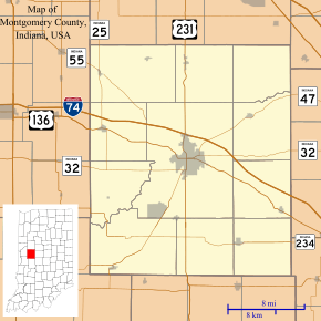 Shannondale Location in Montgomery County | |
| Coordinates: 40°03′17″N 86°41′44″W / 40.05472°N 86.69556°WCoordinates: 40°03′17″N 86°41′44″W / 40.05472°N 86.69556°W | |
| Country | United States |
| State | Indiana |
| County | Montgomery |
| Township | Franklin |
| Elevation[1] | 860 ft (260 m) |
| ZIP code | 46071 |
| FIPS code | 18-68994[2] |
| GNIS feature ID | 443286 |
Shannondale is an unincorporated community in Franklin Township, Montgomery County, Indiana.
History
Shannondale was platted by Isaiah Lame and George Woods in 1851.[3] Nathan Shannon was an early postmaster.[3] The post office was established at Shannondale in 1852, and remained in operation until 1909.[4]
Geography
Shannondale is located at 40°03′17″N 86°41′44″W / 40.05472°N 86.69556°W.
References
- ↑ "US Board on Geographic Names". United States Geological Survey. 2007-10-25. Retrieved 2008-01-31.
- ↑ "American FactFinder". United States Census Bureau. Retrieved 2008-01-31.
- 1 2 Beckwith, Hiram Williams; Kennedy, P. S. (1881). History of Montgomery County, Together with Historic Notes on the Wabash Valley. H. H. Hill and N. Iddings. p. 531.
- ↑ "Montgomery County". Jim Forte Postal History. Retrieved 7 September 2015.
Municipalities and communities of Montgomery County, Indiana, United States | ||
|---|---|---|
| City | ||
| Towns | ||
| Townships | ||
| CDP | ||
| Other unincorporated communities |
| |
This article is issued from Wikipedia - version of the 10/13/2016. The text is available under the Creative Commons Attribution/Share Alike but additional terms may apply for the media files.