Clark Township, Montgomery County, Indiana
| Clark Township | |
|---|---|
| Township | |
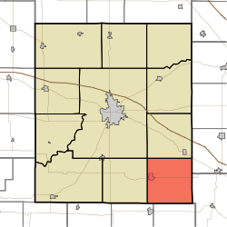 Location in Montgomery County | |
| Coordinates: 39°54′21″N 86°45′30″W / 39.90583°N 86.75833°WCoordinates: 39°54′21″N 86°45′30″W / 39.90583°N 86.75833°W | |
| Country |
|
| State |
|
| County | Montgomery |
| Government | |
| • Type | Indiana township |
| Area | |
| • Total | 36.31 sq mi (94.0 km2) |
| • Land | 36.29 sq mi (94.0 km2) |
| • Water | 0.02 sq mi (0.05 km2) 0.06% |
| Elevation | 876 ft (267 m) |
| Population (2010) | |
| • Total | 1,841 |
| • Density | 50.7/sq mi (19.6/km2) |
| ZIP codes | 46172, 47954, 47968 |
| GNIS feature ID | 0453202 |
Clark Township is one of eleven townships in Montgomery County, Indiana, United States. As of the 2010 census, its population was 1,841 and it contained 812 housing units.[1]
Clark Township was founded in 1830.[2]
Geography
According to the 2010 census, the township has a total area of 36.31 square miles (94.0 km2), of which 36.29 square miles (94.0 km2) (or 99.94%) is land and 0.02 square miles (0.052 km2) (or 0.06%) is water.[1]
Cities, towns, villages
Cemeteries
The township contains these six cemeteries: Harshbarger, Hicks, Inlow, Mount Pleasant, Stoner and Wesley.
Major highways
Lakes
- Morrison Lake
School districts
- South Montgomery Community School Corporation
Political districts
- Indiana's 4th congressional district
- State House District 28
- State Senate District 23
References
- "Clark Township, Montgomery County, Indiana". Geographic Names Information System. United States Geological Survey. Retrieved 2009-09-27.
- United States Census Bureau 2008 TIGER/Line Shapefiles
- IndianaMap
- 1 2 "Population, Housing Units, Area, and Density: 2010 - County -- County Subdivision and Place -- 2010 Census Summary File 1". United States Census. Retrieved 2013-05-10.
- ↑ Beckwith, Hiram Williams; Kennedy, P. S. (1881). History of Montgomery County, Together with Historic Notes on the Wabash Valley. H. H. Hill and N. Iddings. p. 443.
External links
- Indiana Township Association
- United Township Association of Indiana
- City-Data.com page for Clark Township
 |
Union Township | Walnut Township | Jackson Township, Boone County | |
| Scott Township | |
Eel River Township, Hendricks County | ||
| ||||
| | ||||
| Franklin Township, Putnam County | Jackson Township, Putnam County |
Municipalities and communities of Montgomery County, Indiana, United States | ||
|---|---|---|
| City | ||
| Towns | ||
| Townships | ||
| CDP | ||
| Other unincorporated communities |
| |
This article is issued from Wikipedia - version of the 11/25/2016. The text is available under the Creative Commons Attribution/Share Alike but additional terms may apply for the media files.