Waynetown, Indiana
| Waynetown, Indiana | |
|---|---|
| Town | |
 | |
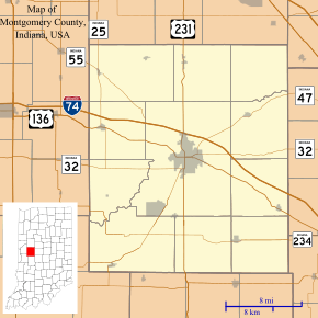 Waynetown, Indiana Wingate's location in Montgomery County | |
| Coordinates: 40°5′15″N 87°3′56″W / 40.08750°N 87.06556°WCoordinates: 40°5′15″N 87°3′56″W / 40.08750°N 87.06556°W | |
| Country | United States |
| State | Indiana |
| County | Montgomery |
| Township | Wayne |
| Area[1] | |
| • Total | 0.48 sq mi (1.24 km2) |
| • Land | 0.48 sq mi (1.24 km2) |
| • Water | 0 sq mi (0 km2) |
| Elevation | 784 ft (239 m) |
| Population (2010)[2] | |
| • Total | 1,007 |
| • Estimate (2012[3]) | 1,007 |
| • Density | 1,995.8/sq mi (770.6/km2) |
| Time zone | Eastern (EST) (UTC-5) |
| • Summer (DST) | EDT (UTC-4) |
| ZIP code | 47990 |
| Area code(s) | 765 |
| FIPS code | 18-82052[4] |
| GNIS feature ID | 0445584[5] |
| Website | http://www.waynetown.net/ |
Waynetown is a town in Wayne Township, Montgomery County, Indiana, United States. The population was 958 at the 2010 census.
History
Waynetown was platted, as "middletown", by Samuel Mann in 1830.[6]
Geography
Waynetown is located at 40°5′15″N 87°3′56″W / 40.08750°N 87.06556°W (40.087559, -87.065562).[7]
According to the 2010 census, Waynetown has a total area of 0.48 square miles (1.24 km2), all land.[1]
Demographics
| Historical population | |||
|---|---|---|---|
| Census | Pop. | %± | |
| 1880 | 569 | — | |
| 1890 | 576 | 1.2% | |
| 1900 | 757 | 31.4% | |
| 1910 | 734 | −3.0% | |
| 1920 | 691 | −5.9% | |
| 1930 | 664 | −3.9% | |
| 1940 | 644 | −3.0% | |
| 1950 | 658 | 2.2% | |
| 1960 | 933 | 41.8% | |
| 1970 | 993 | 6.4% | |
| 1980 | 915 | −7.9% | |
| 1990 | 911 | −0.4% | |
| 2000 | 909 | −0.2% | |
| 2010 | 958 | 5.4% | |
| Est. 2015 | 956 | [8] | −0.2% |
2010 census
As of the census[2] of 2010, there were 1007 people, 391 households, and 282 families residing in the town. The population density was 1,995.8 inhabitants per square mile (770.6/km2). There were 436 housing units at an average density of 908.3 per square mile (350.7/km2). The racial makeup of the town was 98.3% White, 0.2% African American, 0.4% from other races, and 1.0% from two or more races. Hispanic or Latino of any race were 2.0% of the population.
There were 391 households of which 36.8% had children under the age of 18 living with them, 54.0% were married couples living together, 12.0% had a female householder with no husband present, 6.1% had a male householder with no wife present, and 27.9% were non-families. 24.8% of all households were made up of individuals and 9.5% had someone living alone who was 65 years of age or older. The average household size was 2.45 and the average family size was 2.88.
The median age in the town was 37.1 years. 26.6% of residents were under the age of 18; 8.4% were between the ages of 18 and 24; 24.4% were from 25 to 44; 25.2% were from 45 to 64; and 15.4% were 65 years of age or older. The gender makeup of the town was 48.4% male and 51.6% female.
2000 census
As of the census[4] of 2000, there were 909 people, 372 households, and 265 families residing in the town. The population density was 2,085.8 people per square mile (797.7/km²). There were 411 housing units at an average density of 943.1 per square mile (360.7/km²). The racial makeup of the town was 99.34% White, 0.11% African American, and 0.55% from two or more races. Hispanic or Latino of any race were 0.44% of the population.
There were 372 households out of which 32.3% had children under the age of 18 living with them, 56.2% were married couples living together, 9.9% had a female householder with no husband present, and 28.5% were non-families. 25.8% of all households were made up of individuals and 16.7% had someone living alone who was 65 years of age or older. The average household size was 2.44 and the average family size was 2.91.
In the town the population was spread out with 27.3% under the age of 18, 6.6% from 18 to 24, 29.2% from 25 to 44, 21.3% from 45 to 64, and 15.6% who were 65 years of age or older. The median age was 35 years. For every 100 females there were 94.6 males. For every 100 females age 18 and over, there were 91.6 males.
The median income for a household in the town was $37,188, and the median income for a family was $44,191. Males had a median income of $35,313 versus $21,287 for females. The per capita income for the town was $16,328. About 5.9% of families and 8.6% of the population were below the poverty line, including 6.9% of those under age 18 and 13.1% of those age 65 or over.
Government
Waynetown has an elected five-member council which oversees many of the town functions, from grants through utilities, to park and recreation. The town also employs a police department which is made up of numerous deputies and a town marshal. Waynetown has its own utility department, which runs the town utilities and takes care of cleanup throughout the town. The town has two local associations who help oversee the town activities. `
Local festivities
Each year the town of Waynetown holds a "Fish Fry" which also runs a carnival. The Fish Fry brings in many across the county, as well as from surrounding counties such as Fountain, Tippecanoe, and Parke.
Education
North Montgomery School Corporation serves Waynetown.[10] Secondary school students attend Northridge Middle School and North Montgomery High School.
Gallery
 Red brick building is now a Native American Culture Museum and the lighter brick building is the post office
 1830 Pioneer Cemetery
References
- 1 2 "G001 - Geographic Identifiers - 2010 Census Summary File 1". United States Census Bureau. Retrieved 2015-07-25.
- 1 2 "American FactFinder". United States Census Bureau. Retrieved 2012-12-11.
- ↑ "Population Estimates". United States Census Bureau. Retrieved 2013-06-25.
- 1 2 "American FactFinder". United States Census Bureau. Retrieved 2008-01-31.
- ↑ "US Board on Geographic Names". United States Geological Survey. 2007-10-25. Retrieved 2008-01-31.
- ↑ History of Montgomery County, Indiana : with personal sketches of representative citizens. pg 505
- ↑ "US Gazetteer files: 2010, 2000, and 1990". United States Census Bureau. 2011-02-12. Retrieved 2011-04-23.
- ↑ "Annual Estimates of the Resident Population for Incorporated Places: April 1, 2010 to July 1, 2015". Retrieved July 2, 2016.
- ↑ "Census of Population and Housing". Census.gov. Retrieved June 4, 2015.
- ↑ "SCHOOL DISTRICT REFERENCE MAP (2010 CENSUS): Montgomery County, IN." U.S. Census Bureau. Retrieved on November 26, 2016.
Municipalities and communities of Montgomery County, Indiana, United States | ||
|---|---|---|
| City | ||
| Towns | ||
| Townships | ||
| CDP | ||
| Other unincorporated communities |
| |