Walhalla, North Dakota
| Walhalla, North Dakota | |
|---|---|
| City | |
|
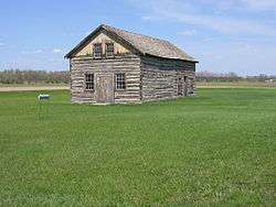
Walhalla Trading Post | |
| Motto: "Heart of the Rendezvous Region"[1] | |
 Location of Walhalla, North Dakota | |
| Coordinates: 48°55′19″N 97°55′5″W / 48.92194°N 97.91806°WCoordinates: 48°55′19″N 97°55′5″W / 48.92194°N 97.91806°W | |
| Country | United States |
| State | North Dakota |
| County | Pembina |
| Area[2] | |
| • Total | 1.07 sq mi (2.77 km2) |
| • Land | 1.05 sq mi (2.72 km2) |
| • Water | 0.02 sq mi (0.05 km2) |
| Elevation | 988 ft (301 m) |
| Population (2010)[3] | |
| • Total | 996 |
| • Estimate (2015)[4] | 951 |
| • Density | 948.6/sq mi (366.3/km2) |
| Time zone | Central (CST) (UTC-6) |
| • Summer (DST) | CDT (UTC-5) |
| ZIP code | 58282 |
| Area code(s) | 701 |
| FIPS code | 38-82980 |
| GNIS feature ID | 1032666[5] |
| Highways | ND 32 |
| Website | City of Walhalla, ND |
Walhalla is a city in Pembina County, North Dakota, United States. It sits on the banks of the Pembina River, five miles (8 km) from the border with Canada. The population was 996 at the 2010 census.[6]
History

Walhalla was established in 1845.[7] Walhalla is the second oldest town in North Dakota, its history bound up in the fur trade of the Red River Valley.[8] One mile northeast of town is the North West Company fur trading post, established in 1797 by David Thompson, and in 1801 moved to a site one mile east of Walhalla, where a reconstructed building is now located.
Also about one mile northeast of Walhalla is the Gingras Trading Post,[9] established in the 1840s by the Métis legislator and businessman Antoine Blanc Gingras.
In town is the Kittson Trading Post, established by Norman Kittson, an American Fur Company agent, in 1843. This is the oldest building in North Dakota. It is located in the Walhalla State Historical Park and is preserved by the State Historical Society.[10]
The Great Northern Railway arrived in Walhalla in 1898.[11]
The town was the site of a protest against TransCanada's Keystone Pipeline in October 2016, when documentarian Deia Schlosberg was arrested.[12]
Geography
Walhalla is located at 48°55′19″N 97°55′5″W / 48.92194°N 97.91806°W (48.921996, -97.918014).[13]
According to the United States Census Bureau, the city has a total area of 1.07 square miles (2.77 km2), of which, 1.05 square miles (2.72 km2) is land and 0.02 square miles (0.05 km2) is water.[2]
Demographics
| Historical population | |||
|---|---|---|---|
| Census | Pop. | %± | |
| 1880 | 67 | — | |
| 1900 | 377 | — | |
| 1910 | 592 | 57.0% | |
| 1920 | 637 | 7.6% | |
| 1930 | 700 | 9.9% | |
| 1940 | 1,138 | 62.6% | |
| 1950 | 1,463 | 28.6% | |
| 1960 | 1,432 | −2.1% | |
| 1970 | 1,471 | 2.7% | |
| 1980 | 1,429 | −2.9% | |
| 1990 | 1,131 | −20.9% | |
| 2000 | 1,057 | −6.5% | |
| 2010 | 996 | −5.8% | |
| Est. 2015 | 951 | [14] | −4.5% |
| U.S. Decennial Census[15] 2015 Estimate[4] | |||
2010 census
As of the census[3] of 2010, there were 996 people, 439 households, and 263 families residing in the city. The population density was 948.6 inhabitants per square mile (366.3/km2). There were 515 housing units at an average density of 490.5 per square mile (189.4/km2). The racial makeup of the city was 88.3% White, 0.1% African American, 8.7% Native American, 0.2% from other races, and 2.7% from two or more races. Hispanic or Latino of any race were 1.7% of the population.
There were 439 households of which 26.9% had children under the age of 18 living with them, 48.1% were married couples living together, 5.9% had a female householder with no husband present, 5.9% had a male householder with no wife present, and 40.1% were non-families. 36.4% of all households were made up of individuals and 16.8% had someone living alone who was 65 years of age or older. The average household size was 2.21 and the average family size was 2.88.
The median age in the city was 45.5 years. 23.8% of residents were under the age of 18; 5.3% were between the ages of 18 and 24; 20.2% were from 25 to 44; 29.7% were from 45 to 64; and 20.7% were 65 years of age or older. The gender makeup of the city was 51.4% male and 48.6% female.
2000 census
As of the census of 2000, there were 1,057 people, 452 households, and 271 families residing in the city. The population density was 1,004.4 people per square mile (388.7/km²). There were 556 housing units at an average density of 528.3 per square mile (204.5/km²). The racial makeup of the city was 89.78% White, 5.96% Native American, 0.09% from other races, and 4.16% from two or more races. Hispanic or Latino of any race were 0.85% of the population.
There were 452 households out of which 25.7% had children under the age of 18 living with them, 49.8% were married couples living together, 5.8% had a female householder with no husband present, and 40.0% were non-families. 36.1% of all households were made up of individuals and 21.9% had someone living alone who was 65 years of age or older. The average household size was 2.23 and the average family size was 2.90.
In the city the population was spread out with 22.4% under the age of 18, 7.2% from 18 to 24, 21.9% from 25 to 44, 24.9% from 45 to 64, and 23.7% who were 65 years of age or older. The median age was 44 years. For every 100 females there were 91.8 males. For every 100 females age 18 and over, there were 88.5 males.
The median income for a household in the city was $31,875, and the median income for a family was $39,375. Males had a median income of $28,095 versus $20,000 for females. The per capita income for the city was $16,894. About 9.7% of families and 12.5% of the population were below the poverty line, including 11.5% of those under age 18 and 14.2% of those age 65 or over.
Attractions
Climate
This climatic region is typified by large seasonal temperature differences, with warm to hot (and often humid) summers and cold (sometimes severely cold) winters. According to the Köppen Climate Classification system, Walhalla has a humid continental climate, abbreviated "Dfb" on climate maps.[16]
References
- ↑ "CITY OF WALHALLA, ND". CITY OF WALHALLA, ND. Retrieved August 16, 2012.
- 1 2 "US Gazetteer files 2010". United States Census Bureau. Retrieved 2012-06-14.
- 1 2 "American FactFinder". United States Census Bureau. Retrieved 2012-06-14.
- 1 2 "Population Estimates". United States Census Bureau. Retrieved June 24, 2016.
- ↑ "US Board on Geographic Names". United States Geological Survey. 2007-10-25. Retrieved 2008-01-31.
- ↑ "2010 Census Redistricting Data (Public Law 94-171) Summary File". American FactFinder. United States Census Bureau. Retrieved 2 May 2011.
- ↑ "HISTORY". CITY OF WALHALLA, ND. Retrieved August 16, 2012.
- ↑ "CITY DATA FOR WALHALLA, NORTH DAKOTA". LandsofAmerica.com. Retrieved August 16, 2012.
- ↑ http://www.nd.gov/hist/gingras/index.html
- ↑ "CITY DATA FOR WALHALLA, NORTH DAKOTA". LandsofAmerica.com. Retrieved August 16, 2012.
- ↑ Hellmann, Paul T. (May 13, 2013). Historical Gazetteer of the United States. Routledge. p. 842. Retrieved 30 November 2013.
- ↑ Visser, Nick (October 14, 2016). "Filmmaker Arrested At Pipeline Protest Facing 45 Years In Felony Charges". The Huffington Post. Retrieved October 16, 2016.
Deia Schlosberg, the producer of the upcoming documentary “How to Let Go of the World and Love All Things Climate Can’t Change,” was detained while filming a protest against TransCanada’s Keystone Pipeline in Walhalla, North Dakota.
- ↑ "US Gazetteer files: 2010, 2000, and 1990". United States Census Bureau. 2011-02-12. Retrieved 2011-04-23.
- ↑ "Annual Estimates of the Resident Population for Incorporated Places: April 1, 2010 to July 1, 2015". Retrieved July 2, 2016.
- ↑ United States Census Bureau. "Census of Population and Housing". Retrieved August 30, 2013.
- ↑ Climate Summary for Walhalla, North Dakota
External links
- Pioneer Women's Histories: Walhalla from the Digital Horizons website
- Walhalla quasquicentennial anniversary :commemorating 125 years of history, June 30 to July 7, 1973 from the Digital Horizons website
Municipalities and communities of Pembina County, North Dakota, United States | ||
|---|---|---|
| Cities | 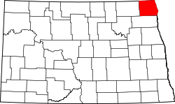 | |
| Townships |
| |
| Unincorporated communities | ||