Saint-Haon-le-Châtel
| Saint-Haon-le-Châtel | ||
|---|---|---|
|
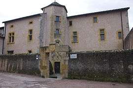
Hôtel Jehan Pelletier, in Saint-Haon-le-Châtel | ||
| ||
 Saint-Haon-le-Châtel | ||
|
Location within Auvergne-Rhône-Alpes region  Saint-Haon-le-Châtel | ||
| Coordinates: 46°04′00″N 3°54′57″E / 46.0667°N 3.9158°ECoordinates: 46°04′00″N 3°54′57″E / 46.0667°N 3.9158°E | ||
| Country | France | |
| Region | Auvergne-Rhône-Alpes | |
| Department | Loire | |
| Arrondissement | Roanne | |
| Canton | Saint-Haon-le-Châtel | |
| Intercommunality | Côte roannaise | |
| Government | ||
| • Mayor | Yves Durand | |
| Area1 | 0.8 km2 (0.3 sq mi) | |
| Population (2009)2 | 577 | |
| • Density | 720/km2 (1,900/sq mi) | |
| Time zone | CET (UTC+1) | |
| • Summer (DST) | CEST (UTC+2) | |
| INSEE/Postal code | 42232 / 42370 | |
| Elevation |
363–463 m (1,191–1,519 ft) (avg. 420 m or 1,380 ft) | |
|
1 French Land Register data, which excludes lakes, ponds, glaciers > 1 km² (0.386 sq mi or 247 acres) and river estuaries. 2 Population without double counting: residents of multiple communes (e.g., students and military personnel) only counted once. | ||
.svg.png)
Saint-Haon-le-Châtel is a commune in the Loire department in central France.
See also
References
| Wikimedia Commons has media related to Saint-Haon-le-Châtel. |
This article is issued from Wikipedia - version of the 10/28/2016. The text is available under the Creative Commons Attribution/Share Alike but additional terms may apply for the media files.