Charlieu
| Charlieu | ||
|---|---|---|
|
The abbey in Charlieu | ||
| ||
 Charlieu | ||
|
Location within Auvergne-Rhône-Alpes region  Charlieu | ||
| Coordinates: 46°09′36″N 4°10′21″E / 46.16°N 4.1725°ECoordinates: 46°09′36″N 4°10′21″E / 46.16°N 4.1725°E | ||
| Country | France | |
| Region | Auvergne-Rhône-Alpes | |
| Department | Loire | |
| Arrondissement | Roanne | |
| Canton | Charlieu | |
| Intercommunality | Le Pays de Charlieu | |
| Government | ||
| • Mayor (2001–2008) | René Lapallus | |
| Area1 | 6.7 km2 (2.6 sq mi) | |
| Population (2009)2 | 3,649 | |
| • Density | 540/km2 (1,400/sq mi) | |
| Time zone | CET (UTC+1) | |
| • Summer (DST) | CEST (UTC+2) | |
| INSEE/Postal code | 42052 / 42190 | |
| Elevation |
268–378 m (879–1,240 ft) (avg. 265 m or 869 ft) | |
|
1 French Land Register data, which excludes lakes, ponds, glaciers > 1 km² (0.386 sq mi or 247 acres) and river estuaries. 2 Population without double counting: residents of multiple communes (e.g., students and military personnel) only counted once. | ||
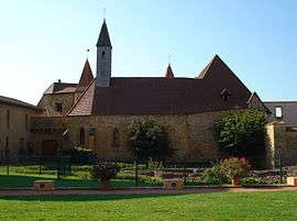

Charlieu is a commune in the Loire department at the northern end of the Auvergne-Rhône-Alpes region of France. It is home to Charlieu Abbey.
Twin towns
It is twinned with the town of Calne in Wiltshire, UK.
See also
External links
| Wikimedia Commons has media related to Charlieu. |
This article is issued from Wikipedia - version of the 11/20/2016. The text is available under the Creative Commons Attribution/Share Alike but additional terms may apply for the media files.