Saint-Genest-Malifaux
| Saint-Genest-Malifaux | ||
|---|---|---|
|
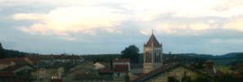
Balcony view of town center | ||
| ||
 Saint-Genest-Malifaux | ||
|
Location within Auvergne-Rhône-Alpes region  Saint-Genest-Malifaux | ||
| Coordinates: 45°20′27″N 4°25′14″E / 45.3408°N 4.4206°ECoordinates: 45°20′27″N 4°25′14″E / 45.3408°N 4.4206°E | ||
| Country | France | |
| Region | Auvergne-Rhône-Alpes | |
| Department | Loire | |
| Arrondissement | Saint-Étienne | |
| Canton | Saint-Genest-Malifaux | |
| Intercommunality | Monts du Pilat | |
| Government | ||
| • Mayor (2014–2020) | Vincent Ducreux | |
| Area1 | 47.08 km2 (18.18 sq mi) | |
| Population (2007)2 | 3,298 | |
| • Density | 70/km2 (180/sq mi) | |
| Time zone | CET (UTC+1) | |
| • Summer (DST) | CEST (UTC+2) | |
| INSEE/Postal code | 42224 / 42660 | |
| Elevation |
680–1,292 m (2,231–4,239 ft) (avg. 960 m or 3,150 ft) | |
|
1 French Land Register data, which excludes lakes, ponds, glaciers > 1 km² (0.386 sq mi or 247 acres) and river estuaries. 2 Population without double counting: residents of multiple communes (e.g., students and military personnel) only counted once. | ||
.svg.png)
Saint-Genest-Malifaux is a small town in the Auvergne-Rhône-Alpes region of central France. Administratively it is designated a commune within the department of Loire.
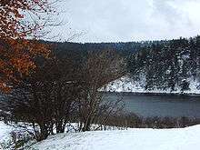
Lake at Saint-Genest-Malifaux

Mayor Vincent Ducreux, June 2013.
See also
References
| Wikimedia Commons has media related to Saint-Genest-Malifaux. |
This article is issued from Wikipedia - version of the 10/28/2016. The text is available under the Creative Commons Attribution/Share Alike but additional terms may apply for the media files.