Fourneaux, Loire
| Fourneaux | ||
|---|---|---|
|
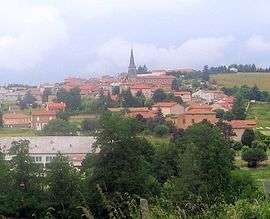
A general view of Fourneaux | ||
| ||
 Fourneaux | ||
|
Location within Auvergne-Rhône-Alpes region  Fourneaux | ||
| Coordinates: 45°56′16″N 4°16′13″E / 45.9378°N 4.2703°ECoordinates: 45°56′16″N 4°16′13″E / 45.9378°N 4.2703°E | ||
| Country | France | |
| Region | Auvergne-Rhône-Alpes | |
| Department | Loire | |
| Arrondissement | Roanne | |
| Canton | Saint-Symphorien-de-Lay | |
| Intercommunality | Communauté de communes du Pays entre Loire et Rhône | |
| Government | ||
| • Mayor (2001–2008) | Claude Janin | |
| Area1 | 12.17 km2 (4.70 sq mi) | |
| Population (1999)2 | 548 | |
| • Density | 45/km2 (120/sq mi) | |
| Time zone | CET (UTC+1) | |
| • Summer (DST) | CEST (UTC+2) | |
| INSEE/Postal code | 42098 / 42470 | |
| Elevation |
416–607 m (1,365–1,991 ft) (avg. 530 m or 1,740 ft) | |
|
1 French Land Register data, which excludes lakes, ponds, glaciers > 1 km² (0.386 sq mi or 247 acres) and river estuaries. 2 Population without double counting: residents of multiple communes (e.g., students and military personnel) only counted once. | ||
.svg.png)
Fourneaux is a commune in the Loire department in central France.
See also
| Wikimedia Commons has media related to Fourneaux (Loire). |
This article is issued from Wikipedia - version of the 2/12/2016. The text is available under the Creative Commons Attribution/Share Alike but additional terms may apply for the media files.