Villerest
| Villerest | ||
|---|---|---|
|
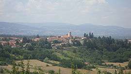
A general view of Villerest | ||
| ||
 Villerest | ||
|
Location within Auvergne-Rhône-Alpes region  Villerest | ||
| Coordinates: 45°59′39″N 4°02′14″E / 45.9942°N 4.0372°ECoordinates: 45°59′39″N 4°02′14″E / 45.9942°N 4.0372°E | ||
| Country | France | |
| Region | Auvergne-Rhône-Alpes | |
| Department | Loire | |
| Arrondissement | Roanne | |
| Canton | Roanne-Sud | |
| Intercommunality | Communauté d'agglomération Grand Roanne Agglomération | |
| Government | ||
| • Mayor (2008–2014) | Paul Court | |
| Area1 | 14.82 km2 (5.72 sq mi) | |
| Population (2006)2 | 4,392 | |
| • Density | 300/km2 (770/sq mi) | |
| Time zone | CET (UTC+1) | |
| • Summer (DST) | CEST (UTC+2) | |
| INSEE/Postal code | 42332 / 42300 | |
| Elevation |
261–426 m (856–1,398 ft) (avg. 360 m or 1,180 ft) | |
|
1 French Land Register data, which excludes lakes, ponds, glaciers > 1 km² (0.386 sq mi or 247 acres) and river estuaries. 2 Population without double counting: residents of multiple communes (e.g., students and military personnel) only counted once. | ||
.svg.png)
Villerest is a commune in the Loire department in central France. It is a Medieval-era commune located just South of the city of Roanne. The village is bordered by the Loire and contains Le Barrage de Villerest, a hydroelectric dam that also prevents flooding along the Loire. This dam also creates a man made lake, the Lac de Villerest. The village itself contains many buildings from the Middle Ages.[1] These include numerous houses, and the Eglise de Saint-Priest. Maybe most famous from this time period would be the ramparts that are still mostly intact today.
See also
International Relations
Twin towns - sister cities
Villerest is twinned with:
References
- ↑ http://www.villerest.fr/presentation/histoire-et-patrimoine/le-moyen-age-naissance-et-vie-d-un-bourg-fortifie.html
- ↑ "Piatra Neamţ - Twin Towns". © 2007-2008 Piatra-Neamt.net. Retrieved 2009-09-27. External link in
|publisher=(help) - ↑ Geograph
| Wikimedia Commons has media related to Villerest. |
This article is issued from Wikipedia - version of the 2/18/2016. The text is available under the Creative Commons Attribution/Share Alike but additional terms may apply for the media files.