La Gresle
| La Gresle | ||
|---|---|---|
|
La Gresle in Spring | ||
| ||
 La Gresle | ||
|
Location within Auvergne-Rhône-Alpes region  La Gresle | ||
| Coordinates: 46°04′35″N 4°16′59″E / 46.0764°N 4.2831°ECoordinates: 46°04′35″N 4°16′59″E / 46.0764°N 4.2831°E | ||
| Country | France | |
| Region | Auvergne-Rhône-Alpes | |
| Department | Loire | |
| Arrondissement | Roanne | |
| Canton | Belmont-de-la-Loire | |
| Intercommunality | Communauté de communes du Canton de Belmont-de-la-Loire | |
| Government | ||
| • Mayor (2008–2014) | M. Jean-Pierre EGLINGER | |
| Area1 | 14.75 km2 (5.70 sq mi) | |
| Population (1999)2 | 745 | |
| • Density | 51/km2 (130/sq mi) | |
| Time zone | CET (UTC+1) | |
| • Summer (DST) | CEST (UTC+2) | |
| INSEE/Postal code | 42104 / 42460 | |
| Elevation |
371–662 m (1,217–2,172 ft) (avg. 500 m or 1,600 ft) | |
|
1 French Land Register data, which excludes lakes, ponds, glaciers > 1 km² (0.386 sq mi or 247 acres) and river estuaries. 2 Population without double counting: residents of multiple communes (e.g., students and military personnel) only counted once. | ||

.svg.png)
La Gresle is a commune in the Loire department in central France.

La Gresle Fall
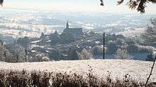
La Gresle Winter
See also
| Wikimedia Commons has media related to La Gresle. |
This article is issued from Wikipedia - version of the 10/28/2016. The text is available under the Creative Commons Attribution/Share Alike but additional terms may apply for the media files.