Coutouvre
| Coutouvre | |
|---|---|
|
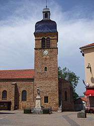
The church in Coutouvre | |
 Coutouvre | |
|
Location within Auvergne-Rhône-Alpes region  Coutouvre | |
| Coordinates: 46°04′24″N 4°12′45″E / 46.0733°N 4.2125°ECoordinates: 46°04′24″N 4°12′45″E / 46.0733°N 4.2125°E | |
| Country | France |
| Region | Auvergne-Rhône-Alpes |
| Department | Loire |
| Arrondissement | Roanne |
| Canton | Perreux |
| Intercommunality | Grand Roanne |
| Area1 | 21.87 km2 (8.44 sq mi) |
| Population (1999)2 | 1,024 |
| • Density | 47/km2 (120/sq mi) |
| Time zone | CET (UTC+1) |
| • Summer (DST) | CEST (UTC+2) |
| INSEE/Postal code | 42074 / 42460 |
| Elevation |
303–538 m (994–1,765 ft) (avg. 450 m or 1,480 ft) |
|
1 French Land Register data, which excludes lakes, ponds, glaciers > 1 km² (0.386 sq mi or 247 acres) and river estuaries. 2 Population without double counting: residents of multiple communes (e.g., students and military personnel) only counted once. | |
Coutouvre is a commune in the Loire department in central France.
It lies about 90 km (56 mi) northwest of Lyon.
People
Coutouvre was the birthplace of:
See also
External links
| Wikimedia Commons has media related to Coutouvre. |
- Official website
- Associations website
- Notre Dame de Prompt Secours (Ecole de Coutouvre) School website
This article is issued from Wikipedia - version of the 10/28/2016. The text is available under the Creative Commons Attribution/Share Alike but additional terms may apply for the media files.