Prescott, Ontario
| Prescott | |
|---|---|
| Town (single-tier) | |
| Town of Prescott | |
 | |
 Prescott | |
| Coordinates: 44°43′N 75°31′W / 44.717°N 75.517°WCoordinates: 44°43′N 75°31′W / 44.717°N 75.517°W | |
| Country |
|
| Province |
|
| County | Leeds and Grenville |
| Settled | 1787 |
| Government | |
| • Mayor | Brett Todd |
| • Federal riding | Leeds—Grenville |
| • Prov. riding | Leeds—Grenville |
| Area[1] | |
| • Land | 4.95 km2 (1.91 sq mi) |
| Population (2011)[1] | |
| • Total | 4,284 |
| • Density | 865.3/km2 (2,241/sq mi) |
| Time zone | EST (UTC-5) |
| • Summer (DST) | EDT (UTC-4) |
| Postal code | K0E |
| Area code(s) | 613 |
| Website | www.prescott.ca |
Prescott, Ontario is a small town located on the north shore of the Saint Lawrence River in the United Counties of Leeds and Grenville, Canada. In 2011, the town had a population of 4284. The Ogdensburg-Prescott International Bridge, 5 kilometres (3.1 mi) east of Prescott at Johnstown, connects the town with Ogdensburg, New York. The town is located about an hour from both Ottawa and Kingston.
The town was founded in the early 19th century by Edward Jessup, a Loyalist soldier during the American Revolution, who named the village after a former Governor-in-Chief, Robert Prescott. Prior to 1834, the town was a part of Augusta township, however in that year the town became a police village, and severed its ties with Augusta.[2] The land here was ideal for settlement during the 18th and 19th centuries as it was situated between Montreal and Kingston along the St. Lawrence River at the head of the rapids.
Prescott is home to the Sandra S. Lawn Harbour, which attracts boaters from as far east as Montreal serving as a picturesque gateway to the Thousand Islands. During the summer months, Prescott hosts the St. Lawrence Shakespeare Festival, a professional theatrical production, at the Harbour's public amphitheatre.
History
French period
In the mid-to-late 1600s, the French occupied the area surrounding what was to become Prescott, Ontario. The first known location of a French settlement was a trading post in 1673 located east of Prescott in what is now Johnstown. By the 1680s, a small French fort was located in what is believed to be Prescott called Fort la Galette; according to O’Callaghan, the fortified post la Galette was located along the St. Lawrence River, north of Ogdensburg.[3] Additionally, according to Queen’s University Quarterly from 1895, the area around Prescott was sometimes referred to as la Galette which it attributed to references to the first fort taken from French diaries.[4] The fort was built to protect their newly established trading posts from British invasion. It is unclear when or why this fort fell into disuse, however Fort de La Présentation was built in close proximity in 1749 which could have been built to replace la Galette. The French left the area after the Battle of the Thousand Islands, and little to no trace of their settlements exist.
Battle of the Thousand Islands
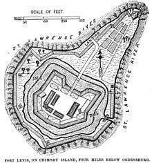
In 1760, the Battle of the Thousand Islands took place near present-day Prescott, Ontario.[5] By 1760, tensions were high between the British and the French who both intended to settle the area located around Prescott. The French began building another fort, slightly east of Prescott on what is presently known as Chimney Island called Fort de Levis.[6] The French forts were no match for the British. When the Battle of the Thousand Islands finally took place in August 1760, the British had 11,000 troops to the French’s 300 men. Despite of this, the French managed to hold back the British for a little over a week, sinking two British ships in the process. When the French ran out of ammunition on August 24, 1760 they surrendered to the British troops.[7] Fort de Levis was renamed Fort Oswegatchie by the British, and was later used in the Revolutionary War.[6] The island on which this fort stood was submerged during the construction of the St. Lawrence Seaway.
Loyalists arrival and first settlement
In and around 1775 during the Revolutionary War, America was politically divided. Many American’s were unsatisfied with British rule and sought their independence. Those who sided with the British or who remained neutral were considered to be rebels or traitors known as Loyalists, and this opposition was met with violence.[8] As tensions escalated, the Loyalists were forced from their homes, fleeing north to what would become Upper Canada. The Loyalists were in a terrible position, as they had fled their homes with few to no possessions, and were unable to return to their homes as the Americans had threatened the lives of any Loyalists attempting to return or collect any belongings. The British attempted to negotiate and failed.[8] Eventually, the British needed to do something to accommodate the misplaced soldiers and their families; in 1783, land was surveyed along the St. Lawrence River surrounding present-day Prescott to be divided amongst the Loyalists as land grants for their loyalty the Crown.[8]
Edward Jessup, born in Stamford, Connecticut in 1735, forfeited 500,000 acres of property near Albany, New York by taking up arms for the King during the Revolutionary War. During the war, he founded the Jessup’s Loyal Rangers who served the British.[9] It is this group of soldiers who first settled Prescott and the surrounding townships after disbanding at the end of the war around 1783.[8] For his loyalty and service, Jessup was awarded extensive lands from the Crown. In 1810, Jessup surveyed a townsite on top of his land, the current location of Prescott, which he named after Robert Prescott, Governor-in-Chief of Canada from 1797-1807. The townsite was one square mile in size. Jessup is credited as the town’s founder.[9]
Early 1800s
Fort Wellington
During the war of 1812, in that year, Prescott witnessed American vessels from Ogdensburg heading for Lake Ontario; volunteers from Prescott quickly set out to investigate, and the vessels surrendered. Later, in the summer of 1812, British and American troops exchanged fire near Brockville. Both of these conflicts made authorities of Prescott believe it was necessary to build a fortification in the town.[10] In July, local residents were employed to built a stockade which would be the main point of defence between Montreal and Kingston during the war. This would become the first Fort Wellington, consisting of a square blockhouse built of wood and earth with barracks, officers’ quarters, stables and storerooms being added shortly after. The first fort needed to be built quickly, and as a result it was ill-constructed and primitive.[10] The second fort, which still stands today, was built in 1838.
War of 1812
In late August, 1812, Prescott received news that General Brock had captured Detroit, however in September, a surprise raid took place at Gananoque, which was poorly defended. The American raiders seized arms and ammunition, as well as set fire to a storehouse.[10] By the fall of 1812, Prescott and Ogdensburg were maintaining friendly relations, however in September this changed when the Americans reinforced the town and fired at convoys of bateaux moving up river with British supplies. The British failed to retaliate at this time.[10] A few months later, in February 1813, the Americans attacked the area again, this time at Brockville; American troops marched to the courthouse and freed the prisoners while taking prominent citizens of the city prisoner.[10]
These attacks by the Americans angered the British troops of Fort Wellington, who decided to take revenge on the Ogdensburg troops for their raids of the area and other provocations. The garrison, led by Lieutenant-Colonel “Red George” MacDonell, set out across the frozen the St. Lawrence River on foot so the American troops would assume it they were performing a drill.[10] Instead, the plan was for the Glengarry Light Infantry to attack the fort and barracks, while the Fort Wellington garrison attacked the flank. Initially the 500 men stationed at the Ogdensburg fort refused to surrender, however when British troops entered the fort the Americans evacuated the fort and retreated fourteen miles.[10]
According to Mcdonell’s own account of the following events, the troops then burned the old and new barracks, as well as two schooners, the gun boats, guard houses, scows and a few houses.[10] Overall, the attack was a success for the Fort Wellington soldiers. Prescott saw no further action, and the war ended soon after in 1814.
Battle of the Windmill
Fort Wellington became part of its second conflict in 1838, known as the Battle of the Windmill. This battle occurred when a small group of American soldiers called Patriots were convinced that the Canadians across the river in Prescott wanted to be freed from British “oppression” and essentially wanted to restart the rebellion by planning an invasion. Although no war ended up occurring, a battle took place when the Patriots attempted to cross into Prescott. The currents of the St. Lawrence caused problems, trapping their vessels on sandbars before forcing them to land east of Prescott in the new town of Newport, the site of a stone windmill. This gave troops from Fort Wellington plenty of time to prepare for what they assumed was an attack. The Americans eventually surrendered to the British troops, and were sent to Kingston for trial; eleven people, including their leader, were executed as punishment.[10]
Forwarding industry
Due to Prescott’s location at the head of the rapids and it’s excellent harbour, it became a vital transfer point for freight travelling up the river. In 1810, a wharf and warehouse were built and a forwarding business was established by a William Gilkinson; it was the first of many forwarding operations in the town.[10] Prescott exported large amounts of lumber, potash and other goods. The forwarding trade led to shipbuilding developments also taking place in Prescott, with many ships being launched from its harbour. Prescott forwarders, by 1833, had formed well-established connections with the steamboat lines running from Prescott to Montreal which allowed the forwarders here to prosper over others in the area.[10]
Forwarding became obsolete in the area much later, with the establishment of the railroads. The original forwarding warehouse built by Gilkinson is still standing, currently used as a museum dedicated to Prescott’s forwarding industry. The building is made of stone, but has been covered in white stucco. It was used as an American consulate, a lawyer’s office and later a laundromat before being purchased by the historical society in 1970.[10]
Later history
In the late 1980s, Prescott became infamous when one of the largest sexual abuse investigations in Canada was conducted, dubbed Project Jericho.[11][12] The multiple-victim and multiple-offender case began in August, 1989, after a young girl disclosed the details of the abuse to her foster parents. Five years later, close to 300 victims and over 100 perpetrators had been named in the investigations.[12] This case was unique, as never before had a multi-victim, multi-offender case of this magnitude been confined to such a small, defined, geographical region without being enclosed within an institution.[12] According to some sources, Project Jericho remains the largest sex abuse investigation in Canadian history.[13] The investigation was a joint effort between many organizations; Project Jericho consisted of members of the Ontario Provincial Police and local police departments, a Special Crown Attorney and victim/witness assistance coordinator, Family and Children’s Services of Leeds-Grenville, the town of Prescott council, the Ontario government’s Ministry of Community and Social Services, as well as the Adult Mental Health services.[12]
The precise nature of the abuse varied from victim to victim, and is still disputed to this day. According to initial reports, the seven-year-old female who came forward in 1989 stated that on top of the sexual abuse, she and other children were submerged in water, confined beneath the floor, and forced to drink “yucky juice”, which some have speculated to be blood.[12] Additionally, adults are said to have terrorized or threatened her and other children with guns, knives and other weapons. Many of these abuses were documented on videotape.[12] In addition to the abuse, victims alleged an infant boy, known only as "Joshua", had been murdered by the accused abusers. Little information is known regarding the infant or the murder, and no body was ever found. Project Jericho was named in honour of the alleged murder victim.[12]
By 1990, arrests were being made with charges against four individuals being laid while 37 individuals were confirmed or suspected victims; some children began to be removed from their homes.[12] By 1994, the total number of child victims had skyrocketed to 162, with the number of perpetrators being 119. Of these offenders, 97 were male and 22 were female. The victims were primarily child victims, around 162 being children; while 113 were adults, who came forward to disclose abuse suffered as children.[12] Of the 65 cases that went to trial, the investigation saw a conviction rate of 91%.[14][12]

Cemeteries
Prescott in home to two cemeteries, Sandy Hill Cemetery and St. Mark’s Roman Catholic Cemetery. Sandy Hill Cemetery is located along Edward Street across from South Grenville District High School and is one of the oldest burying grounds in the area.[15] The land for this cemetery was given to the town in 1830, in Edward Jessup III’s will, which stated the area then known as Sand Hill was to become a “burial ground for the different churches in the town of Prescott.”.[15] Prior to becoming the town’s cemetery, the area was already used as a burial ground for the Jessup family. The earliest known burial was that of Susannah Jessup’s father who died in 1798.[15] Edward Jessup I, the original recipient of the land here was also buried in the cemetery early, in 1816. Along the south side of the front of the cemetery are many unmarked graves of pioneers who died of cholera.[15] In 1929, the cemetery was expanded and the entrance gates added. In 1967, the stone steps leading up the hill to the Jessup family graves were placed.[15] This cemetery is still in use today.
The Roman Catholics of Prescott were originally buried in Sandy Hill cemetery, which had a reserved area specifically for Roman Catholic burials. In the mid-1800s, the population of Roman Catholics felt as though they needed their own cemetery, and land was purchased from a local for $1 by a local reverend to become a new cemetery in 1859 with additional land purchased in 1875.[15] This cemetery is located north of the 401 on the west side of County Road 18 and is known as St. Mark’s Cemetery. The older, back section of the cemetery was blessed in 1860, and the newer part in 1935.[15] The earliest legible tombstone in the cemetery dates to before the land was purchased, and belongs to a Thomas Allen who died in 1845.[15] This cemetery is also currently still in use.
Churches
Currently, Prescott in home to six churches, all of which are still in operation. The town contains a Presbyterian, Anglican, Roman Catholic, United, Pentecostal and an Evangelist church. The Pentecostal church, called Seaway Christian Church is located on Churchill road and the Evangelist church, called Harvest Church, is located on Edward street; services are currently held in these churches regularly.[16][17]
St. Andrew’s Presbyterian church is located on the corner of Centre and Dibble street in Prescott. The first St. Andrew’s Presbyterian, located on the same site as the current church, was constructed in 1821 and dedicated in 1822. The first church was a frame structure built on land donated by Susannah Jessup. This church was replaced in 1850 by a stone church which burned in 1892. The present building replaced it in 1893. Prior to this church, the Presbyterian congregation met in the schoolhouse at the corner of West and King street. St. Andrew’s is still in use today.[10]

St. John’s Anglican church in Prescott is located at the corner of James and Centre street. The first church to be erected on this site as St. John’s was a frame building, erected in 1821 on land donated by Susannah Jessup. The present, gothic-style church was erected in 1860 to replace the frame building. This building is still in use as a church, with parts of it currently being renovated into apartments.[10]
The Roman Catholic church, known as St. Mark’s Roman Catholic Church was built in the 1830s on land purchased from the Jessup family. Prior to its construction, a Roman Catholic priest served the area out of homes or community buildings. The present church stands on the same location as the original St. Mark’s on Dibble street.[10]
Currently, St. Paul’s United Church is located on George street, however the former site of the St. Paul’s United Church was on Dibble street, near St. Mark’s church. Between the years 1854 and 1856, the Wesleyan Methodist congregation in Prescott planned, financed and erected their own church. This church became known as St. Paul’s United church. On July 28, 1979, the church was burned beyond repair, and demolished.[18] Sometime after the fire, a new St. Paul’s United Church was built to serve the congregation; this school is still used today.
Demographics
| Canada census – Prescott, Ontario community profile | |||
|---|---|---|---|
| 2011 | 2006 | 2001 | |
| Population: | 4284 (2.5% from 2006) | 4180 (-1.1% from 2001) | 4228 (-5.6% from 1996) |
| Land area: | 4.95 km2 (1.91 sq mi) | 4.95 km2 (1.91 sq mi) | 4.95 km2 (1.91 sq mi) |
| Population density: | 865.3/km2 (2,241/sq mi) | 844.4/km2 (2,187/sq mi) | 854.0/km2 (2,212/sq mi) |
| Median age: | 44.3 (M: 42.4, F: 46.2) | 41.7 (M: 39.0, F: 43.9) | |
| Total private dwellings: | 2063 | 2054 | 2009 |
| Median household income: | $40,100 | $33,741 | |
| References: 2011[19] 2006[20] 2001[21] | |||
Population trend:[22]
| Historical populations | ||
|---|---|---|
| Year | Pop. | ±% |
| 1991 | 4,512 | — |
| 1996 | 4,480 | −0.7% |
| 2001 | 4,228 | −5.6% |
| 2006 | 4,180 | −1.1% |
| 2011 | 4,284 | +2.5% |
Mother tongue:[20]
- English as first language: 91%
- French as first language: 4%
- English and French as first language: 0%
- Other as first language: 5%

Notable people
- Leo Boivin, ice hockey player and member of the Hockey Hall of Fame
- Jean Casselman Wadds, politician
- James Morrow Walsh, North-West Mounted Police officer
- Ben Hutton - ice hockey player
- Thomas Pope, mayor of Quebec City
- Alaine Chartrand - figure skater
- Matthew Markell - figure skater
References
- 1 2 "Prescott census profile". 2011 Census of Population. Statistics Canada. Retrieved 2012-02-15.
- ↑ Goldie A. Connell (1985) Augusta: Royal Township Number Seven. St. Lawrence Printing Co. ltd. p. 262
- ↑ "The Jesuit Relations and Allied Documents Volume 62". creighton.edu.
- ↑ Queen's Quarterly. Quarterly Committee of Queen's University. 1895. p. 321.
- ↑ "Battles of the French and Indian War: The Thousand Islands «". mrnussbaum.com.
- 1 2 "Fort 1749 - History of The Fort". fort1749.org.
- ↑ "Battle of the Thousand Islands". weebly.com.
- 1 2 3 4 Goldie A. Connell (1985) Augusta: Royal Township Number Seven. St. Lawrence Printing Co. ltd. p. 3-16
- 1 2 "Prescott's Col. Edward Jessup…A Loyalist and Adirondack Lumber Baron". wordpress.com. 30 March 2016.
- 1 2 3 4 5 6 7 8 9 10 11 12 13 14 15 McKenzie, R. (n.d.). Leeds and Grenville: Their First 200 Years. McClelland and Stewart.
- ↑ Ra_watch (2006-11-14). "1995: Ritual abuse prosecution in Canada". livejournal.com.
- 1 2 3 4 5 6 7 8 9 10 "The Prescott Case: Key Dates and Events". Care for Kids - Jericho. Leeds, Grenville and Lanark District Health Unit. Retrieved 5 October 2012.
- ↑ Michael Woods (28 April 2014). "Number of potential victims a challenge for investigator in Gallagher sex assault case". ottawacitizen.com.
- ↑ Steed, Judy (1994). "Prescott: Breaking the Cycle". Our Little Secret. Random House. pp. 107–130. ISBN 0394223187.
- 1 2 3 4 5 6 7 8 Goldie A. Connell (1985) Augusta: Royal Township Number Seven. St. Lawrence Printing Co. ltd. p. 211-213
- ↑ "Seaway Christian Church". seawaychurch.ca.
- ↑ "HARVEST CHURCH PRESCOTT ONTARIO". harvestchurchprescott.com.
- ↑ McGaughey, E. (1980). A Firm Foundation: A History of St. Paul's United Church. Kingston: Brown and Martin.
- ↑ "2011 Community Profiles". Canada 2011 Census. Statistics Canada. July 5, 2013. Retrieved 2012-02-15.
- 1 2 "2006 Community Profiles". Canada 2006 Census. Statistics Canada. March 30, 2011. Retrieved 2012-02-15.
- ↑ "2001 Community Profiles". Canada 2001 Census. Statistics Canada. February 17, 2012. Retrieved 2012-02-15.
- ↑ Statistics Canada: 1996, 2001, 2006 census
External links
| Wikimedia Commons has media related to Prescott, Ontario. |
| Wikivoyage has a travel guide for Prescott, Ontario. |
Local Media
 |
Augusta | | ||
| Augusta | |
Edwardsburgh/Cardinal | ||
| ||||
| | ||||
| Saint Lawrence River |
| Regions | |
|---|---|
| Counties | |
| Districts | |
| Regional municipalities | |
| Single-tier municipalities | |
| Separated municipalities | |
| |