Belleville, Ontario
| Belleville | |
|---|---|
| City (single-tier) | |
| City of Belleville | |
|
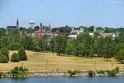
Belleville skyline | |
 Belleville | |
| Coordinates: 44°10′N 77°23′W / 44.167°N 77.383°WCoordinates: 44°10′N 77°23′W / 44.167°N 77.383°W | |
| Country |
|
| Province |
|
| County | Bay of Quinte |
| Settled | 1789 |
| Named | 1816 |
| Incorporated | 1836 (as police village) |
| Incorporated as city | 1878 |
| Government[1] | |
| • Mayor | Taso Christopher |
| • Federal riding | Bay of Quinte |
| • Prov. riding | Prince Edward—Hastings |
| Area[2][3] | |
| • Land | 247.21 km2 (95.45 sq mi) |
| • Metro | 741.36 km2 (286.24 sq mi) |
| Population (2011)[2][3] | |
| • City (single-tier) | 49,454 |
| • Density | 200.0/km2 (518/sq mi) |
| • Metro | 92,540 |
| • Metro density | 124.8/km2 (323/sq mi) |
| Time zone | EST (UTC−5) |
| • Summer (DST) | EDT (UTC−4) |
| Postal Code FSA | K8N, K8P, K8R |
| Area code(s) | 613, 343 |
| Website | www.city.belleville.on.ca |
Belleville (Canada 2011 Census population 49,454;[2] census agglomeration population 92,540[3]) is a city located at the mouth of the Moira River on the Bay of Quinte in Southern (Central) Ontario, Canada, along the Quebec City-Windsor Corridor. It is the seat of Hastings County, but politically independent of it, and is the centre of the Bay of Quinte Region.
History
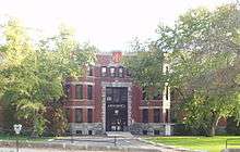
.jpg)
Originally the site of an Anishinaabe (Mississaugus) village in the 18th century known as Asukhknosk, the future location of the city was settled by United Empire Loyalists, after which it became known as Meyer's Creek after prominent settler and industrialist John Walden Meyers.[5] It was renamed Belleville in honour of Lady Arabella Gore in 1816, after a visit to the settlement by Sir Francis Gore and his wife.
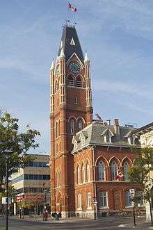
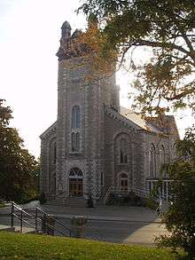
Belleville became an important railway junction with the completion of the Grand Trunk Railway in 1855. In 1858 the iron bridge over the Moira River at Bridge Street became the first iron bridge in Hastings County. Belleville's beautiful High Victorian Gothic city hall was built in 1872 to house the public market and administrative offices.[6] The City Hall tower stands some 185 feet (56 m) above street level.
The Dixie Lee Fried Chicken chain (1964) and the Journey's End Corporation economy limited service hotel chain (1978) were both founded in the city.
In 1998, the city was amalgamated with the surrounding Township of Thurlow to form an expanded City of Belleville as part of Ontario-wide municipal restructuring. The city also annexed portions of Quinte West to the west.
Geography and climate
Belleville is located at the mouth of the Moira River on the Bay of Quinte in southeastern Ontario between the cities of Quinte West to the west and Napanee to the east. These cities are connected by both Ontario's Highway 2 and the Macdonald-Cartier Freeway (Highway 401); The city is also served by Highway 37, running north-south from Belleville towards Tweed to the east of the Moira River; and Highway 62 (once Highway 14 south of 401), northwards towards Madoc, and southward to Prince Edward County over the Bay Bridge.
Belleville is located in a transitional zone which may be considered part of the Central Ontario or Eastern Ontario regions by different sources. Officially, Belleville is properly considered part of the Central Ontario region as it is located west of the St. Lawrence River's starting point, but the city is popularly considered part of Eastern Ontario as it shares the eastern region's area code 613 and K postal code.
Climate
Belleville's climate has four distinctive seasons. The City's traditional continental climate (hot summers, cold winters) is moderated by its location near Lake Ontario. The lake moderates temperature extremes, cooling hot summer days and warming cold days during the fall and winter. As such, winter snowfall is somewhat limited due to the increased frequency of precipitation falling as rain during the winter months. In the summer months, severe thunderstorm activity is usually limited because of the non-favourable lake breeze conditions. The city, being located on the north shore of Lake Ontario, is also in an unfavourable location for lake effect snow. One notable exception however, was in December 2010 when 14 cm of snow occurred in one day as a result of a snow band from Lake Ontario. The summer months do not typically experience exceedingly hot temperatures, however humidity levels can make daytime highs uncomfortable. Summer rainfall is usually modest, and delivered by passing thunderstorms or warm fronts. Remnants of tropical systems do pass through on occasion towards summer's end, resulting in one or two days of consistently wet weather. The winter season is highly variable, with the record setting winter of 2007-08 experiencing near 270 cm of snow. Four years later, the winter of 2011-12 experienced only 60 cm of snow. Winter temperatures are also highly variable, even in one season. Air masses change frequently, and while a few days may see above freezing temperatures at a time in January, the next week may bring cold and snowfall. Autumn is usually mild, with an increase in precipitation starting in late September as conditions for fall storms develop. Recent years have had a tendency to bring almost snow free Novembers to the region.
The highest temperature ever recorded in Belleville was 104 °F (40.0 °C) on 9 July 1936.[7] The coldest temperature ever recorded was −39 °F (−39.4 °C) on 9 February 1934.[7]
- Mean Daily Temperature - Annually = 8.1 °C (46.6 °F)
- Mean Maximum Highest Temperature - Summer = 26.8 °C (80.2 °F)
- Mean Minimum Lowest Temperature - Winter = −11.1 °C (12.0 °F)
- Growing Degree-Days = 2236
- Growing Season = 190–200 days
- Mean Annual Precipitation = 911.6 mm (35.89 in)
- Mean Annual Snow Fall = 139.7 cm (55.0 in)
- Average Number of Days with Precipitation = 149 days
- Average Number of Days with Snowfall = 41 days
- Average Number of Days with max. temperature > 0 °C (32 °F) = 312 days
| Climate data for Belleville, 1981−2010 normals, extremes 1866−present | |||||||||||||
|---|---|---|---|---|---|---|---|---|---|---|---|---|---|
| Month | Jan | Feb | Mar | Apr | May | Jun | Jul | Aug | Sep | Oct | Nov | Dec | Year |
| Record high °C (°F) | 14.5 (58.1) |
13.0 (55.4) |
23.0 (73.4) |
29.0 (84.2) |
35.0 (95) |
35.6 (96.1) |
40.0 (104) |
36.1 (97) |
35.0 (95) |
28.3 (82.9) |
22.2 (72) |
16.5 (61.7) |
40.0 (104) |
| Average high °C (°F) | −2.2 (28) |
−0.5 (31.1) |
4.1 (39.4) |
11.7 (53.1) |
18.7 (65.7) |
23.9 (75) |
26.8 (80.2) |
25.7 (78.3) |
21.0 (69.8) |
13.7 (56.7) |
7.2 (45) |
1.2 (34.2) |
12.6 (54.7) |
| Daily mean °C (°F) | −6.7 (19.9) |
−5.1 (22.8) |
−0.4 (31.3) |
7.0 (44.6) |
13.7 (56.7) |
19.0 (66.2) |
21.8 (71.2) |
20.8 (69.4) |
16.3 (61.3) |
9.5 (49.1) |
3.6 (38.5) |
−2.6 (27.3) |
8.1 (46.6) |
| Average low °C (°F) | −11.1 (12) |
−9.7 (14.5) |
−5 (23) |
2.3 (36.1) |
8.7 (47.7) |
14.0 (57.2) |
16.9 (62.4) |
15.9 (60.6) |
11.7 (53.1) |
5.3 (41.5) |
0.1 (32.2) |
−6.3 (20.7) |
3.6 (38.5) |
| Record low °C (°F) | −37.8 (−36) |
−39.4 (−38.9) |
−29.4 (−20.9) |
−17.2 (1) |
−7.2 (19) |
0.0 (32) |
6.1 (43) |
3.3 (37.9) |
−1.7 (28.9) |
−10 (14) |
−22.2 (−8) |
−34.4 (−29.9) |
−39.4 (−38.9) |
| Average precipitation mm (inches) | 67.3 (2.65) |
58.1 (2.287) |
62.4 (2.457) |
75.8 (2.984) |
81.3 (3.201) |
74.5 (2.933) |
65.1 (2.563) |
75.5 (2.972) |
91.9 (3.618) |
85.2 (3.354) |
95.7 (3.768) |
79.1 (3.114) |
911.6 (35.89) |
| Average rainfall mm (inches) | 30.6 (1.205) |
29.4 (1.157) |
40.3 (1.587) |
69.2 (2.724) |
81.2 (3.197) |
74.5 (2.933) |
65.1 (2.563) |
75.5 (2.972) |
91.9 (3.618) |
84.9 (3.343) |
84.7 (3.335) |
44.6 (1.756) |
771.9 (30.39) |
| Average snowfall cm (inches) | 36.8 (14.49) |
28.6 (11.26) |
22.1 (8.7) |
6.5 (2.56) |
0.0 (0) |
0.0 (0) |
0.0 (0) |
0.0 (0) |
0.0 (0) |
0.2 (0.08) |
11.0 (4.33) |
34.5 (13.58) |
139.7 (55) |
| Average precipitation days (≥ 0.2 mm) | 15.4 | 11.8 | 12.0 | 12.2 | 12.4 | 11.6 | 9.7 | 10.5 | 11.3 | 13.5 | 14.0 | 14.2 | 148.6 |
| Average rainy days (≥ 0.2 mm) | 5.3 | 4.9 | 7.4 | 11.0 | 12.3 | 11.6 | 9.7 | 10.5 | 11.3 | 13.4 | 11.4 | 7.5 | 116.2 |
| Average snowy days (≥ 0.2 cm) | 11.7 | 8.5 | 6.4 | 2.1 | 0.04 | 0.0 | 0.0 | 0.0 | 0.0 | 0.12 | 3.7 | 8.8 | 41.2 |
| Source: Environment Canada[7][8] | |||||||||||||
Government
Belleville City Council
Local government is represented by Belleville City Council with a mayor and eight councillors. There are two city wards with Ward 1 (Belleville) represented by six councillors and Ward 2 (Thurlow) by two councillors. Ward 1 consists of the historic city and Ward 2 was created in 1998 with the amalgamation of Township of Thurlow.
City Council sits at Belleville City Hall.
Economy
Procter & Gamble, Kellogg's, Bardon Supplies Limited, Redpath, Parmalat, Sigma Stretch, Magna, Amer Sports Canada, Sears and Avaya (formerly Nortel) are corporations operating in Belleville. Many other manufacturing sector companies operate within the City of Belleville, including Bioniche Life Sciences, Sprague Foods, Airborne Systems Canada Ltd, Berry Plastics Canada, Sigma Stetch Film Canada, CpK Interior Products, Halla Climate Control Canada, Reid's Dairy, Parmalat Canada - Black Diamond Cheese Division, Kelloggs Canada and Norampac Inc, just to name a few.
Belleville is home to two shopping malls: The Bay View Mall in east-end Belleville and the Quinte Mall along Highway 401 in North Belleville.
Quinte Economic Development Commission
The Quinte Economic Development Commission is the regional economic development office representing the City of Belleville, the City of Quinte West and the Municipality of Brighton. The Quinte EDC is mandated with the responsibility for regional marketing for its member municipalities as well as supporting existing industries through regional strategies.
Transportation
The City of Belleville is located within a 15-minute drive of 8 Wing / Canadian Forces Base (CFB) Trenton. 8 Wing CFB Trenton is Canada’s largest Canadian Forces Air Base and is available for commercial flights for passenger and cargo uses, by prior arrangement with DND. There is a Customs and Immigration office located on site for international flights. Airport facilities include snow removal, crash response, fire fighting and rescue services, 24-hour-a-day air traffic control tower, fully equipped airfield navigational and visual approach, and one paved runway which is 10,000 feet long and can accommodate 747 and C5A classes.
Belleville is serviced by the 401 highway system, and bus service to and from Toronto International Airport is provided three times daily each way by Megabus. Deseronto Transit provides public transportation services to destinations including Deseronto, Napanee, and Prince Edward County.[9]
Belleville is located on the Toronto-Montreal main rail lines for both Canadian National Railway and Canadian Pacific Railway; both companies provide freight access. VIA Rail also operates five daily passenger services each way along its Windsor–Québec rail corridor.
Major routes in Belleville
- Highway 62/North Front Street
- Highway 62 runs from the northern city limit with the Township of Centre Hastings to the southern boundary with the Municipality of Prince Edward County (where the highway crosses the Norris Whitney Bridge over the Bay of Quinte). From Highway 401 south to the Canadian National Railways overpass, 62 follows North Front Street. South of there, as that street splits entering downtown, 62 follows the eastern branch, Pinnacle Street, across the Sagonaska Bridge and through downtown. 62 then turns East at Dundas Street (old Highway 2), and continues to Bay Bridge Drive, where the highway heads south into 'the County'.
- Highway 37/Cannifton Road Parkway
- Highway 37 runs from the northern city limit with Tweed south to the 401, where it is co-designated as Cannifton Road Parkway until it meets Station Street. There, it follows Station Street west to its terminus at Pinnacle Street downtown.
- Highway 2/Dundas Street
- Running across southern Belleville, Dundas Street is a four-lane highway from where it enters Belleville's west end at Wallbridge-Loyalist Road to Point Anne Road, approximately 11 km east. Highway 2 originally crossed the Moira River at the Lower Bridge, co-designated with Bridge Street, but when Dundas Street finally crossed the Moira in the early 1970s, the old route was forgotten, although it is still signed as Highway 2.
- Of interest is the eastern section of Dundas Street where, as Highway 2, it was rebuilt in the late 1930s as a "dual highway" (four lanes), to the same standards as the concurrent Queen Elizabeth Way. Part of a period of freeway design experimentation in Ontario, it was never upgraded in the same manner as the QEW, as Highway 2 was supplanted by the new 401 as the major transportation corridor along Lake Ontario.[10] It remains today as an example of early freeway design.
- Bell Boulevard/Adam Street
- Bell in 2010 was extended east to the Moira River, where the new Veterans Memorial Bridge connects it to Adam Street, with the combined route now connecting Wallbridge-Loyalist Road on the western boundary of Belleville, running through the North-west Industrial Park and over the Moira as it passes through Riverside Park, ultimately ending at University Avenue, in the city's North-East Industrial Park. From Sidney Street east to North Park Street, Bell is home to a variety of commercial properties, including Reid's Dairy and the Quinte Mall, as well as a number of restaurants, hotels and motels.
- College Street/Airport Parkway
- College Street runs from the residential area of West Park Village, across the city to the North-East Industrial Park. Branching off of College and running east to Shannonville Road is Airport Parkway, formerly known as the Byron Street Extension.
Demographics
| Historical population | ||
|---|---|---|
| Year | Pop. | ±% |
| 1841 | 2,040 | — |
| 1851 | 4,593 | +125.1% |
| 1871 | 7,305 | +59.0% |
| 1881 | 9,516 | +30.3% |
| 1891 | 9,916 | +4.2% |
| 1901 | 9,117 | −8.1% |
| 1911 | 9,876 | +8.3% |
| 1921 | 12,206 | +23.6% |
| 1931 | 13,790 | +13.0% |
| 1941 | 15,498 | +12.4% |
| 1951 | 19,519 | +25.9% |
| 1961 | 30,655 | +57.1% |
| 1971 | 35,128 | +14.6% |
| 1981 | 34,881 | −0.7% |
| 1991 | 37,243 | +6.8% |
| 1996 | 37,083 | −0.4% |
| 2001 | 45,986 | +24.0% |
| 2006 | 48,821 | +6.2% |
| 2011 | 49,454 | +1.3% |
| [11] The 1991 and 1996 populations are 44,858 and 45,069 respectively when adjusted to the 2001 boundaries. The 2001 population is 46,029 when adjusted to the 2006 boundaries. | ||
According to the 2011 Canadian Census,[12] the population of Belleville is 49,454, a 1.3% increase from 2006. The population density is 200.0 people per square km. The median age is 43.5 years old, a bit higher than the national median at 40.6 years old. There are 22,153 private dwellings with an occupancy rate of 95.1%. According to the 2011 National Household Survey, the median value of a dwelling in Belleville is $200,473 which is a fair bit lower than the national average at $280,552. The median household income (after-taxes) in Belleville is $48,552, not much lower than the national average at $54,089.
Belleville is mostly made up of European descents. The racial make up of Belleville is:
- 90.7% White
- 4.4% Aboriginal; 2.9% First Nations, 1.1% Metis
- 1.3% South Asian
- 1.0% East Asian; 0.5% Chinese, 0.3% Korean, 0.2% Japanese
- 0.9% Black
- 0.6% Southeast Asian; 0.2% Filipino
- 0.4% Latin American
- 0.2% West Asian
- 0.2% Arab
- 0.1% Multiracial; 1.2% including Metis
- 0.2% Other
Most of Belleville is either a Christian (67.1%), or affiliates with no religion (30.3%). The remaining 2.6% affiliate with another religion.
| Canada census – Belleville, Ontario community profile | |||
|---|---|---|---|
| 2011 | 2006 | 2001 | |
| Population: | 49,454 (1.3% from 2006) | 48,821 (6.1% from 2001) | 46,029 (-0.5% from 1996) |
| Land area: | 247.21 km2 (95.45 sq mi) | 246.76 km2 (95.27 sq mi) | 241.79 km2 (93.36 sq mi) |
| Population density: | 200.0/km2 (518/sq mi) | 197.8/km2 (512/sq mi) | 190.2/km2 (493/sq mi) |
| Median age: | 41.8 (M: 40.2, F: 43.2) | 39.7 (M: 38.2, F: 41.1) | |
| Total private dwellings: | 22,153 | 21,239 | 20,239 |
| Median household income: | $48,567 | $41,175 | |
| References: 2011[13] 2006[14] 2001[15] | |||
The city of Belleville, with the amalgamation of the Township of Thurlow, and the annexation of a portion of the City of Quinte West, had a population of 48,821 people in the Canada 2006 Census. Belleville is the largest urban centre in a much larger market area generally known as the Quinte Region. The city's census agglomeration had a population of 91,518 in the 2006 census.
Population trend:[11]
- Population in 2011: 49,454
- Population in 2006: 48,821
- Population in 2001: 45,986 (or 46,029 when adjusted to 2006 boundaries)
- Population in 1996:
- Belleville (city): 37,083
- Thurlow (township): 7,986
- Population in 1991:
- Belleville (city): 37,243
- Thurlow (township): 7,615
Mother tongue:[18]
- English as first language: 90.8%
- French as first language: 1.5%
- English and French as first language: 0.2%
- Other as first language: 7.5%
Education
Belleville offers a number of options at the elementary, secondary, and post-secondary levels.
Post-secondary
Academy of Learning College is a local college.
Loyalist College is a local public college.
Public schools
The Public school system is served by the Hastings & Prince Edward District School Board. The Catholic School system is served by the Algonquin and Lakeshore Catholic District School Board.
| Public Secondary schools |
|---|
| Centennial Secondary School |
| Moira Secondary School |
| Quinte Secondary School |
| Bayside Secondary School (Quinte West) |
| Public Elementary schools |
|---|
| Susanna Moodie Elementary School |
| Parkdale Public Elementary School |
| Queen Elizabeth Elementary School |
| Prince of Wales Elementary School |
| Harry J. Clarke Elementary School (French immersion) |
| Queen Victoria Elementary School |
| Chase Maracle Elementary School |
| Sir John A Macdonald School |
| Hillcrest Elementary School |
| Prince Charles Elementary School |
| Foxboro Public School |
| Bayside Elementary School (French immersion) |
| Harmony Public School |
Separate schools
Following are Belleville area schools managed by the Algonquin and Lakeshore Catholic District School Board.
| Separate board Secondary schools |
|---|
| Nicholson Catholic College |
| St. Theresa Catholic Secondary School |
| Separate board Elementary schools |
|---|
| Our Lady of Fatima Catholic School |
| St Michael's Catholic School (French immersion) |
| St Joseph's Catholic School |
| Georges Vanier Catholic School |
| Holy Rosary Catholic School |
Provincial schools
| Provincial Demonstration schools |
|---|
| Sir James Whitney School for the Deaf |
| Sagonaska School |
Private schools
| Private schools |
|---|
| Academy of Learning College |
| Quinte Ballet School of Canada |
| Quinte Christian High School |
| Belleville Christian School |
| Belleville Montessori School |
| Albert College |
Sports teams
Belleville was home to the Belleville Bulls of the Ontario Hockey League, who were sold and the franchise moved to Hamilton. They played at the Yardmen Arena, located on Cannifton Road. Belleville was also previously home to two senior hockey teams, the Belleville Macs and the Belleville McFarlands. The McFarlands won the Allan Cup in 1958, and the World Championship in 1959. Belleville is also home the Bay of Quinte Yacht Club, which challenged for the America's Cup in 1881. Belleville also has some other teams, such as the Belleville Bearcats and the Belleville Jr. Bulls.
On September 25, 2016, the Ottawa Senators announced that their AHL affiliate will move from Binghamton, New York, to Belleville for the 2017-18 season. The new team will be known as the Belleville Senators.[19]
Media
- Belleville Intelligencer (daily)
Radio
| Frequency | Call sign | Branding | Format | Owner | Notes |
|---|---|---|---|---|---|
| AM 800 | CJBQ | CJBQ 800 | Full service | Quinte Broadcasting | |
| FM 91.3 | CJLX-FM | 91X | Campus radio | Loyalist College | |
| FM 94.3 | CJBC-1-FM | Ici Radio-Canada Première | Talk radio, public radio | Canadian Broadcasting Corporation | Rebroadcaster of CJBC (Toronto) |
| FM 95.5 | CJOJ-FM | 95.5 Hits FM | Adult hits | Starboard Communications | |
| FM 97.1 | CIGL-FM | Mix 97 | Hot adult contemporary | Quinte Broadcasting | |
| FM 100.1 | CHCQ-FM | Cool 100.1 | Country music | Starboard Communications | |
| FM 102.3 | CKJJ-FM | UCB Radio | Christian radio | United Christian Broadcasters Canada | |
| FM 107.1 | CJTN-FM | Rock 107 | Classic rock | Quinte Broadcasting |
Television
| OTA virtual channel (PSIP) | OTA actual channel | Call sign | Network | Notes |
|---|---|---|---|---|
| 26.1 | 26 (UHF) | CICO-DT-53 | TVOntario | Rebroadcaster of CICA-DT (Toronto) |
Internet
- Quinte Frontpage
- QNet News
Theatre
- Pinnacle Playhouse
- The Empire Theatre
- Moonpath Productions
Annual events
January
- Civic Levee
February
- Downtown Docfest
June
- Berrylicious
- Rockfest
July
- Belleville's Canada D'Eh
- Waterfront and Ethnic Festival
August
- Quinte Ribfest
September
- Quinte Fall Fair and Exhibition
- Porchfest Belleville
November
- Belleville Festival of Trees
- Belleville Nighttime Santa Claus Parade
- Christmas at the Pier
December
- Christmas at the Pier
Sister cities
The City of Belleville has three Sister City arrangements with communities outside of Canada which include:[20]
 Lahr, Germany - Established in 1971
 Gunpo, South Korea - Established in 1996
 Zhucheng, People's Republic of China - Established in 1996
Notable people
- Lee Aaron, hard rock and jazz singer. Best known for "Metal Queen"
- Marianne Ackerman, playwright, novelist, and journalist
- Drew Bannister, professional ice hockey defenceman
- Dennis Bock, novelist and short story writer
- Michael Botterill, professional Canadian football linebacker
- Sir MacKenzie Bowell, Canada's fifth Prime Minister
- Wilfred Leigh Brintnell, a pioneering Canadian aviator
- James Brown, politician
- Stevie Cameron, award-winning investigative journalist and best-selling author
- Matt Cooke, NHL hockey player
- Brander Craighead, football player
- Bob Crawford, retired NHL hockey player
- Lou Crawford, former OHL and AHL head coach
- Marc Crawford, NHL head coach
- Bob Dillabough, retired NHL player with the Detroit Red Wings, Boston Bruins and the Oakland Seals
- Herbert Henry Dow, Dow Chemical, Born February 26, 1866
- Rick Green, retired NHLer
- Ellie Anne Harvie, actress
- Bobby Hull, Hockey Hall of Fame member
- Brett Hull, son of Bobby, Hockey Hall of Fame member (inducted 2009)
- Dennis Hull, Bobby's younger brother, member of 1972 Team Canada
- Aislinn Hunter, poet and fiction writer
- Frances Itani, fiction writer, poet and essayist
- Avril Lavigne, Canadian singer/songwriter, born in Belleville, moved to Napanee at age five
- James Frederick Lister, lawyer
- Norm Maracle, hockey goaltender
- James Marker, inventor of Cheezies[21]
- Rick Meagher, retired NHL player
- Rick Mofina, author of crime fiction and thriller novels
- Susanna Moodie (1803-1885), author, moved to Belleville with her husband in 1840 after several years spent "roughing it in the bush" near Lakefield, Ontario
- Riyo Mori, Miss Universe 2007 spent her teenage years in Belleville, studying at Centennial Secondary School and at Quinte Ballet School of Canada[22]
- Farley Mowat, author, born in Belleville
- William Barton Northrup, lawyer and politician
- Brian Orser, figure skater and coach
- Shawn O'Sullivan, 1984 Olympic silver medalist boxer
- Pete Quaife, bassist for The Kinks in the 1960s, lived in Quinte Region from 1980 to 2005
- Peter Quinney, Canadian football player, Toronto Argonauts
- Andrew Raycroft, NHL goaltender
- Brad Richardson, NHL forward
- Alexander Milton Ross, abolitionist and agent for the Underground Railroad
- Johnny Rutherford, former Major League Baseball pitcher
- Nancy Anne Sakovich, actress and former model
- Mike Schad, National Football League offensive lineman; attended Moira Secondary School
- Martin Seemungal, Foreign Correspondent CBC, ABC, CTV, PBS Newshour
- Andrew Shaw, NHL player, currently playing for the Montreal Canadiens
- Derek Smith, NHL forward
- Matt Stajan, NHL forward resided in Belleville from 2000-2004
- Manly E. MacDonald, Semi-impressionistic painter
- Alex Stieda, former professional road bicycle racer
- Chris Valentine, former ice hockey player and coach
- Thomas Campbell Wallbridge, lawyer and politician
- John Weldon, animated movies director, Oscar Award winner (1979)
- Ed Westfall, retired NHL player
- The Wilkinsons, country music group
- Ty Wishart, professional ice hockey player
- Jerry Yanover, political advisor
See also
References
- ↑ "Meet Mayor Taso A. Christopher". City of Belleville. Retrieved 18 December 2015.
- 1 2 3 "Belleville census profile". 2011 Census of Population. Statistics Canada. Retrieved 2012-02-29.
- 1 2 3 "Belleville (Census agglomeration) census profile". 2011 Census of Population. Statistics Canada. Retrieved 2012-02-29.
- ↑ "Armoury - Recognized Federal Heritage Building - Belleville, Ontario". Parks Canada. Retrieved 18 December 2015.
- ↑ Boyce, Gerry (2008) Belleville - A Popular History
- ↑ Archived March 20, 2012, at the Wayback Machine.
- 1 2 3 "Belleville, Ontario". Canadian Climate Normals 1981–2010. Environment Canada. Retrieved April 9, 2014.
- ↑ "Daily Data Report for January 2013". Canadian Climate Data. Environment Canada. Retrieved 24 July 2016.
- ↑ deseronto.ca: "Transit"
- ↑ "Ontario Highway 2 Photographs - Page 9 - History of Ontario's Kings Highways". Thekingshighway.ca. Retrieved 2014-06-13.
- 1 2 Statistics Canada: 1996, 2001, 2006 census
- ↑ "National Household Survey (NHS) Profile, 2011". 2.statcan.gc.ca. Retrieved 2014-06-13.
- ↑ "2011 Community Profiles". Canada 2011 Census. Statistics Canada. July 5, 2013. Retrieved 2012-02-29.
- ↑ "2006 Community Profiles". Canada 2006 Census. Statistics Canada. March 30, 2011. Retrieved 2012-02-29.
- ↑ "2001 Community Profiles". Canada 2001 Census. Statistics Canada. February 17, 2012. Retrieved 2012-02-29.
- ↑ "2001 Community Profiles". 2.statcan.gc.ca. 2013-08-26. Retrieved 2014-06-13.
- ↑ "2001 Community Profiles". 2.statcan.gc.ca. 2013-08-26. Retrieved 2014-06-13.
- ↑ "2006 Community Profiles - Community highlights for Clearview". 2006 Census data. Statistics Canada. Retrieved 2010-12-15.
- ↑ Andrew Foote (26 September 2016). "Senators moving minor league team to Belleville, Ont.". CBC News Ottawa. Retrieved 26 September 2016.
- ↑ "Cultural Exchange Committee". City of Belleville. Retrieved 18 December 2015.
- ↑ Ciarula Taylor, Lesley (2012-05-03). "Cheezies inventor dies in Belleville, Ont., at 90". Toronto Star. Retrieved 2012-05-15.
- ↑ "New Miss Universe studied in Ont". Cnews.canoe.ca. 2007-05-29. Retrieved 2014-06-13.
External links
| Wikimedia Commons has media related to Belleville, Ontario. |
-
 Belleville, Ontario travel guide from Wikivoyage
 - City of Belleville
- Belleville is part of The Great Waterway tourism region from the Seaway Valley to Lake Ontario
- Sagonaska Demonstration School for Students with Learning Disabilities
 |
Stirling-Rawdon | Centre Hastings | Tweed | |
| Quinte West | |
Tyendinaga Township Tyendinaga Mohawk Territory | ||
| ||||
| | ||||
| Bay of Quinte Prince Edward County |
| Regions | |
|---|---|
| Counties | |
| Districts | |
| Regional municipalities | |
| Single-tier municipalities | |
| Separated municipalities | |
| |
| Cities |  | |
|---|---|---|
| Towns | ||
| Townships | ||
| First Nations | ||
| Indian reserves | ||
| ||