Guelph
| Guelph | |||||
|---|---|---|---|---|---|
| City (single-tier) | |||||
| City of Guelph | |||||
|
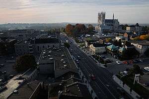
View of Guelph downtown with Norfolk St. and Basilica of Our Lady Immaculate pictured | |||||
| |||||
| Nickname(s): "The Royal City"[1] | |||||
| Motto: Faith, Fidelity and Progress | |||||
 Guelph Location of Guelph in Ontario | |||||
| Coordinates: 43°33′N 80°15′W / 43.550°N 80.250°WCoordinates: 43°33′N 80°15′W / 43.550°N 80.250°W | |||||
| Country |
| ||||
| Province |
| ||||
| County | Wellington County (independent) | ||||
| City Wards | 6 | ||||
| Founded | April 23, 1827 | ||||
| Incorporated | April 23, 1879 | ||||
| Government | |||||
| • Mayor |
Cam Guthrie 2014-Present | ||||
| • Governing Body | Guelph City Council | ||||
| • MPs |
Lloyd Longfield (LPC) 2015 - Present | ||||
| • MPPs |
Liz Sandals (OLP) 2003 - Present | ||||
| Area[2][3] | |||||
| • Land | 86.72 km2 (33.48 sq mi) | ||||
| • Urban | 78.39 km2 (30.27 sq mi) | ||||
| • Metro | 378.45 km2 (146.12 sq mi) | ||||
| Elevation | 334 m (1,096 ft) | ||||
| Population (2011)[2][3] | |||||
| • City (single-tier) | 121,688 | ||||
| • Density | 1,325.5/km2 (3,433/sq mi) | ||||
| • Urban | 121,688 | ||||
| • Urban density | 1,475.1/km2 (3,820/sq mi) | ||||
| • Metro | 141,097 | ||||
| • Metro density | 335.6/km2 (869/sq mi) | ||||
| Demonym(s) | Guelphite | ||||
| Time zone | EST (UTC−5) | ||||
| • Summer (DST) | EDT (UTC−4) | ||||
| Postal code span | N: N1C, N1E, N1G, N1H, N1K, N1L | ||||
| Area code(s) | 519, 226 and 548 | ||||
| Website |
www | ||||


Guelph (![]() i/ɡwɛlf/; Canada 2011 Census population 121,688)[2] is a city in southwestern Ontario, Canada. Known as "The Royal City", Guelph is roughly 28 kilometres (17 mi) east of Waterloo and 100 kilometres (62 mi) west of Downtown Toronto at the intersection of Highway 6 and Highway 7. It is the seat of Wellington County, but is politically independent of it. Because of its low crime rates, clean environment and generally high standard of living, Guelph is consistently rated as one of Canada's best places to live.[4][5] Guelph has been noted as having one of the lowest unemployment rates in the country throughout the 2008–2012 global recession,[6] and has ranked at the bottom of Canada's crime severity list since 2007.[7]
i/ɡwɛlf/; Canada 2011 Census population 121,688)[2] is a city in southwestern Ontario, Canada. Known as "The Royal City", Guelph is roughly 28 kilometres (17 mi) east of Waterloo and 100 kilometres (62 mi) west of Downtown Toronto at the intersection of Highway 6 and Highway 7. It is the seat of Wellington County, but is politically independent of it. Because of its low crime rates, clean environment and generally high standard of living, Guelph is consistently rated as one of Canada's best places to live.[4][5] Guelph has been noted as having one of the lowest unemployment rates in the country throughout the 2008–2012 global recession,[6] and has ranked at the bottom of Canada's crime severity list since 2007.[7]
History
Before colonization, the area was considered by the surrounding indigenous communities to be a "neutral" zone. On selected dates, members from these communities would meet and trade goods by the Speed River.
Guelph was selected as the headquarters of British development firm "the Canada Company" by its first superintendent John Galt, a popular Scottish novelist who designed the town to attract settlers and the surrounding countryside.[8] Galt designed the town to resemble a European city centre, complete with squares, broad main streets and narrow side streets, resulting in a variety of block sizes and shapes which are still in place today.[9] The street plan was laid out in a radial street and grid system that branches out from downtown, a technique which was also employed in other planned towns of this era, such as Buffalo, New York.[8]
The Canada Company established Guelph in 1827 to serve as the company's headquarters during the development of the Huron Tract, although town later came into its own as a prosperous railway and industrial centre.[10] Guelph was founded by the symbolic felling of a tree[11] on St. George's Day, April 23, 1827, the feast day of the patron saint of England.[9] The town was named to honour Britain's royal family, the Hanoverians, who were descended from the Guelfs, the ancestral family of George IV, the reigning British monarch; thus the nickname The Royal City. The directors of the Canada Company had actually wanted the city to be named Goderich, but reluctantly accepted the fait accompli. Guelph was incorporated as a city in 1879.[12]
The Canadian Communist Party began as an illegal organization in a rural barn near the town of Guelph, Ontario, on May 28 and 29, 1921.[13]
Guelph was the home of North America's first cable TV system. Fredrick T. Metcalf created MacLean Hunter Television (now part of Rogers Communications) and their first broadcast was Queen Elizabeth's Coronation in 1953.[14]
Guelph's police force had Canada's first municipal motorcycle patrol. Chief Ted Lamb brought back an army motorcycle he used during the First World War. Motorcycles were faster and more efficient than walking.[14]
The city is home to the University of Guelph and Sleeman Breweries Ltd.. The Ontario Agricultural College (OAC), the oldest part of University of Guelph, began in 1873 as an associate agricultural college of the University of Toronto. Guelph Collegiate Vocational Institute (GCVI), established in the 1840s, is one of the province's oldest high schools.
Guelph has three National Historic Sites of Canada: the Basilica of Our Lady Immaculate, McCrae House and Old City Hall.[15]
Etymology
The name Guelph comes from the Italian Guelfo and the Bavarian-Germanic Welf. It is a reference to the reigning British monarch at the time Guelph was founded, King George IV, whose family was from the House of Hanover, a younger branch of the House of Welf.[14] In Italy, during the late Medieval period and up until the 15th century, a conflict between the Guelfi neri, the Guelfi bianchi, and the Ghibellines ensued throughout the Italian peninsula. The Guelfi were named after an aristocratic family that ruled various parts of Europe at different times.
Geography and climate
Topography and water courses
Downtown Guelph is situated above the confluence of the Speed and Eramosa Rivers, which have numerous tributaries. The Speed River enters from the north and the Eramosa River from the east; the two rivers meet below downtown and continue southwest, where they merge with into the Grand River. There are also many creeks and rivers creating large tracts of densely forested ravines, and providing ideal sites for parks and recreational trails. The city is built on several drumlins and buried waterways, the most notable being an underground creek flowing below the Albion Hotel, once the source of water used to brew beer.
Climate
This region of Ontario has cold winters and warm, humid summers, falling into the Köppen climate classification Dfb zone, with moderately high rainfall and snowfall. It is generally a couple of degrees cooler than lower elevation regions on the Great Lakes shorelines, especially so in winter, the exception being on some spring afternoons when the lack of an onshore breeze boosts temperatures well above those found lakeside.
The highest temperature ever recorded in Guelph was 101 °F (38.3 °C) on 6 August 1918 and 13 July 1936.[16][17] The coldest temperature ever recorded was −35 °F (−37.2 °C) on 25 January 1884.[18]
| Climate data for University of Guelph Arboretum, 1981−2010 normals, extremes 1881−present | |||||||||||||
|---|---|---|---|---|---|---|---|---|---|---|---|---|---|
| Month | Jan | Feb | Mar | Apr | May | Jun | Jul | Aug | Sep | Oct | Nov | Dec | Year |
| Record high °C (°F) | 16.7 (62.1) |
14.6 (58.3) |
26.4 (79.5) |
29.2 (84.6) |
32.2 (90) |
36.2 (97.2) |
38.3 (100.9) |
38.3 (100.9) |
36.7 (98.1) |
29.4 (84.9) |
23.9 (75) |
19.1 (66.4) |
38.3 (100.9) |
| Average high °C (°F) | −3 (27) |
−2.1 (28.2) |
3.4 (38.1) |
11.4 (52.5) |
18.4 (65.1) |
23.4 (74.1) |
25.9 (78.6) |
24.5 (76.1) |
19.8 (67.6) |
13.1 (55.6) |
6.2 (43.2) |
0.0 (32) |
11.7 (53.1) |
| Daily mean °C (°F) | −6.9 (19.6) |
−6.3 (20.7) |
−1.4 (29.5) |
6.0 (42.8) |
12.2 (54) |
17.1 (62.8) |
19.7 (67.5) |
18.6 (65.5) |
14.1 (57.4) |
8.1 (46.6) |
2.4 (36.3) |
−3.5 (25.7) |
6.7 (44.1) |
| Average low °C (°F) | −10.8 (12.6) |
−10.5 (13.1) |
−6.1 (21) |
0.6 (33.1) |
6.0 (42.8) |
10.8 (51.4) |
13.7 (56.7) |
12.6 (54.7) |
8.4 (47.1) |
3.0 (37.4) |
−1.3 (29.7) |
−7 (19) |
1.6 (34.9) |
| Record low °C (°F) | −37.2 (−35) |
−32.8 (−27) |
−28.9 (−20) |
−16.7 (1.9) |
−7.8 (18) |
−1.1 (30) |
1.7 (35.1) |
−1.1 (30) |
−6.7 (19.9) |
−12.8 (9) |
−20.6 (−5.1) |
−31.1 (−24) |
−37.2 (−35) |
| Average precipitation mm (inches) | 51.9 (2.043) |
58.0 (2.283) |
66.9 (2.634) |
73.7 (2.902) |
79.7 (3.138) |
78.8 (3.102) |
95.8 (3.772) |
92.8 (3.654) |
90.4 (3.559) |
71.6 (2.819) |
91.2 (3.591) |
80.5 (3.169) |
931.3 (36.665) |
| Average rainfall mm (inches) | 17.6 (0.693) |
24.1 (0.949) |
43.8 (1.724) |
69.9 (2.752) |
79.6 (3.134) |
78.8 (3.102) |
95.8 (3.772) |
92.8 (3.654) |
90.4 (3.559) |
70.1 (2.76) |
81.2 (3.197) |
38.1 (1.5) |
782.0 (30.787) |
| Average snowfall cm (inches) | 38.6 (15.2) |
37.2 (14.65) |
26.4 (10.39) |
3.8 (1.5) |
0.07 (0.028) |
0.0 (0) |
0.0 (0) |
0.0 (0) |
0.0 (0) |
1.5 (0.59) |
9.0 (3.54) |
38.6 (15.2) |
155.1 (61.06) |
| Average precipitation days (≥ 0.2 mm) | 16.2 | 12.8 | 12.7 | 13.7 | 13.3 | 11.8 | 11.7 | 13.5 | 14.1 | 14.6 | 16.0 | 16.8 | 167.0 |
| Average rainy days (≥ 0.2 mm) | 4.0 | 3.9 | 7.9 | 12.3 | 13.3 | 11.8 | 11.7 | 13.5 | 14.1 | 14.5 | 13.4 | 6.9 | 127.4 |
| Average snowy days (≥ 0.2 cm) | 12.7 | 9.6 | 5.9 | 1.6 | 0.07 | 0.0 | 0.0 | 0.0 | 0.0 | 0.43 | 3.4 | 11.0 | 44.7 |
| Mean monthly sunshine hours | 80.4 | 96.7 | 146.3 | 172.5 | 230.7 | 256.5 | 277.9 | 236.7 | 172.2 | 140.6 | 82.1 | 55.4 | 1,947.9 |
| Percent possible sunshine | 27.8 | 32.8 | 39.7 | 42.9 | 50.6 | 55.7 | 59.5 | 54.7 | 45.8 | 41.0 | 28.1 | 19.8 | 41.5 |
| Source: Environment Canada[19][20][18][16][17][21] | |||||||||||||
Economy
The city of Guelph has a diversified economy that helped Guelph obtain the lowest unemployment rate in the country at 4.2% in 2011.[6]
Manufacturing is the leading sector, accounting for 24.3% of employment (2006 census). The second largest industry is Educational services, accounting for 11.3%.[22]
26.1% (90/345) of business in the manufacturing industry are categorized as Fabricated Metal Product Manufacturing businesses.[23]
The City of Guelph's Economic Development Strategy identified life science, agri-food and biotechnology firms, environmental management and technology companies as growth industries on which to focus economic development activities.[24]
Guelph's 3 largest employers include Linamar (8000), the University of Guelph (3700), and the Upper Grand District School Board (3400).[22][25]
Demographics
| 2011 National Household Survey | Population | % of Total Population | |
|---|---|---|---|
| Ethnicity group Source:[26] | White | 101,630 | 84.3 |
| South Asian | 4,970 | 4.1 | |
| Chinese | 3,350 | 2.8 | |
| Southeast Asian | 2,890 | 2.4 | |
| Filipino | 1,960 | 1.6 | |
| Black | 1,695 | 1.4 | |
| Latin American | 1,150 | 1.0 | |
| West Asian | 975 | 0.8 | |
| Multiple visible minorities | 655 | 0.5 | |
| Arab | 640 | 0.5 | |
| Korean | 280 | 0.2 | |
| Other visible minority | 205 | 0.2 | |
| Japanese | 145 | 0.1 | |
| Total population | 120,545 | 100 | |
| Ethnic Origin | Population | Percent |
|---|---|---|
| English | 36,975 | 31.93% |
| Canadian | 36,845 | 31.82% |
| Scottish | 27,875 | 24.07% |
| Irish | 24,445 | 21.11% |
| German | 14,505 | 12.52% |
| Italian | 11,135 | 9.61% |
| Historical populations | ||
|---|---|---|
| Year | Pop. | ±% |
| 1841 | 1,240 | — |
| 1851 | 1,860 | +50.0% |
| 1871 | 6,878 | +269.8% |
| 1881 | 9,890 | +43.8% |
| 1891 | 10,537 | +6.5% |
| 1901 | 11,496 | +9.1% |
| 1911 | 15,175 | +32.0% |
| 1921 | 18,128 | +19.5% |
| 1931 | 21,075 | +16.3% |
| 1941 | 23,074 | +9.5% |
| 1951 | 27,386 | +18.7% |
| 1961 | 39,838 | +45.5% |
| 1971 | 60,087 | +50.8% |
| 1981 | 71,207 | +18.5% |
| 1991 | 87,976 | +23.5% |
| 1996 | 95,821 | +8.9% |
| 2001 | 106,170 | +10.8% |
| 2006 | 114,943 | +8.3% |
| 2011 | 121,688 | +5.9% |
Guelph is the fifth fastest growing city in Canada with a population growth rate of about 2% per year. According to the Ontario Places to Grow plan, Guelph's population is projected to be about 144,500 by the year 2021. Population varies throughout the year because of variations in the University of Guelph student population.[27]
The 2001 census enumerated 114,943 residents of Guelph. 49.1% were male and 50.9% were female. 6.2% were under five. The average age is 35.7 years of age. Between 1996 and 2001, the population of Guelph grew 10.7%. The 2011 metro population density of Guelph was 335.6 people per square kilometre.
Historically, Guelph's population has been principally British in origin, with 92% in 1880 and 87% in 1921.[8]
The city is mostly Christian: 74.17%, almost evenly split among Protestants and Roman Catholics. The largest non-Christian religion is Buddhism: 1.45%, followed by Islam.[28]
Education
Four school boards operate in the city. The Upper Grand District School Board administers all of Wellington County, as well as adjacent Dufferin County, while the Wellington Catholic District School Board administers Catholic education in Wellington County, including Guelph. The Conseil scolaire de district catholique Centre-Sud offers French First language education for students with parents who had elementary and secondary education in French at École Saint-René-Goupil. The Conseil scolaire Viamonde, with similar entrance requirements, operates the École élémentaire L'Odyssée.There are also numerous private schools in Guelph: Cornerstone Canadian Reformed Christian School, Resurrection Christian Academy, Guelph Community Christian School, Guelph Montessori School, Trillium Waldorf School, Wellington Hall Academy, and Wellington Montessori School, Echo Montessori. An International Baccalaureate Program is available at Guelph C.V.I.
Secondary schools
Due to the presence of two different English school boards, Guelph has numerous elementary and secondary schools. The secondary schools are as follows:
Public:
Catholic:
- Our Lady of Lourdes C.H.S.
- Saint James C.H.S.
- Bishop Macdonell C.H.S.
- St. John Bosco Secondary School
Post-secondary institutions
- University of Guelph, one of Canada's top comprehensive universities, and home to the Ontario Agricultural College and the Ontario Veterinary College.
- Conestoga College has a small campus in Guelph.
Public library system

Although a private library had existed since 1832, a public library did not exist in Guelph until 1882, when the Free Libraries Act allowed municipalities to operate libraries. After occupying premises near City Hall, it moved into an Andrew Carnegie-funded building in 1905,[29] which was eventually demolished in 1964. The current main library building was opened in 1965.[30]
Guelph is served by a growing library system composed of a main library located in the downtown core, five branches and a Bookmobile. With a membership of over 85,000, the Guelph Public Library system's goals include preserving and indexing public materials relating to the history of Guelph. Although no formal program has been developed, the library acquires municipal records of archival value from the City of Guelph.
Government
Municipal
The city is a single-tier municipality governed by a mayor-council system. The structure of the municipal government is stipulated by the Ontario Municipal Act of 2001. There are currently 12 councillors and a mayor, with two councillors representing each of the six wards.
The mayor and members of the city council serve four-year terms without term limits, with the next election in October 2018. Prior to the 2006 election, the mayor and city councillors served three-year terms.
Guelph City Council is responsible for policy and decision making, monitoring the operation and performance of the city, analyzing and approving budgets and determining spending priorities.
In 2014, Ward 4 councillor Cam Guthrie defeated incumbent Karen Farbridge, 50% to 36% for the position of mayor. Five incumbent councillors were re-elected, four rookie councillors were elected, three former councillors were elected, two incumbents were defeated, and four did not seek re-election.
Provincial
Guelph occupies a single provincial riding of the same name, and is currently represented in the Legislative Assembly of Ontario by Liz Sandals, a member of the ruling Ontario Liberal Party. Sandals was named Ontario's Minister of Education in February 2013.[31]
Federal
Guelph also occupies a federal riding of the same name. The member of Parliament is Lloyd Longfield of the Liberal Party of Canada.
Culture


Historic sites
- Downtown Guelph: Many downtown streets are lined with Victorian era buildings, which are now well over a century old.
- Guelph Civic Museum, a museum located on Catholic Hill adjacent to the Basilica of Our Lady Immaculate. At Guelph Civic Museum one can find pictures, films and other antique materials related to the historic development of the City of Guelph.
- St. Patrick's Ward
- Goldie Mill ruins: Once owned by the Goldie family, an important name in the early Waterloo Region, the mill was operated until 1953 when a fire destroyed it. It now serves as a venue for outdoor public and private events.
National Historic Sites
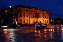
- Old City Hall, a formal, classical civic building; built in 1856-57.
- McCrae House, home of John McCrae, author of "In Flanders Fields".
- Basilica of Our Lady Immaculate, a Roman Catholic church designed by Joseph Connolly, located downtown, is a local landmark.
Outdoor attractions
Most of the natural attractions of Guelph are located beside the two rivers which pass inside the city, Speed River and Eramosa River.
- Guelph Lake
- University of Guelph Arboretum
- Riverside Park, located beside the Speed River at north of Guelph
- York Road Park
- Hanlon Creek Park (Preservation Park)
- Royal City Park and Wellington Street nature sites
- Exhibition Park (the oldest park in Guelph)
Festivals
- Guelph Contemporary Dance Festival
- Guelph Pride Week
- Guelph and District Multicultural Festival
- Hillside Festival
- Two Rivers Festival
- John Galt Day
- Festival Italiano
- Guelph Jazz Festival
- Guelph Festival of Moving Media
- Faery Fest[32]
Arts facilities
- The Macdonald Stewart Art Centre
- The Bookshelf Ebar Art Space
- Ed Video Media Arts Centre
- River Run Centre
- Guelph Youth Music Centre[33]
Entertainment
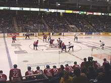
The Sleeman Centre is a sports and entertainment venue in Guelph. The large, modern facility allows for a variety of events such as concerts, sporting and family events, trade shows and conferences, and it is home to the local hockey team, the Guelph Storm.[34]
Music
From a Bell Organ factory to the opera singer Edward Johnson, Guelph has been a source of musical contribution. Today, Guelph has a thriving indie rock scene, which has spawned some of Canada's more well-known indie bands. Guelph is also home to the Hillside Festival, a hugely popular music festival held at nearby Guelph Lake during the summer, as well as the Guelph Jazz Festival.[35]
Guelph is also home to the Guelph Symphony Orchestra,[36] and two yearly classical music festivals. The Kiwanis Music Festival of Guelph showcases students from Guelph and surrounding areas,[37] while the Guelph Musicfest offers performances by local professional classical musicians.[38]
Sports teams
| Club | League | Sport | Venue | Established | Championships |
|---|---|---|---|---|---|
| Guelph Storm | Ontario Hockey League | Hockey | Sleeman Centre | 1991 |
3 |
| Guelph Royals | Intercounty Baseball League | Baseball | David E. Hastings Stadium at Exhibition Park (Guelph) | 1919 | 8 |
| Guelph Gryphons | Canadian Interuniversity Sport | University | W.F. Mitchell Centre and Alumni Stadium | 1874 | 0 |
| Guelph Regals | Ontario Lacrosse Association | Lacrosse | Victoria Road Recreation Centre | 1992 | 1 |
| Guelph Rangers | Ontario Soccer League, Kitchener and District Soccer League, South West Region Soccer League, | Soccer | Centennial Park and Guelph Lake Sports Fields | circa 1985 | 3 |
| Guelph Hurricanes | Greater Ontario Junior Hockey League | Hockey | Sleeman Centre | 1963 | 0 |
| Guelph Bears | Ontario Football Conference | Football | University of Guelph's Alumni Stadium | 1997 | 0 |
| Guelph Gargoyles | Ontario Australian Football League | Australian Football | Margaret Green Park | 2001 | 0 |
| Royal City Roller Girls | Full Member WFTDA League[39] | Roller Derby | Arenas in Guelph (Victoria Road Rec Centre, Exhibition Park, West End Rec Centre) | 2010 | 0 |
| Speed River Track and Field Club | Athletics Canada | Athletics | Alumni Stadium | 1997 | 10 |
Transportation
Bus
Guelph Transit provides local transportation around the city. On June 20, 2007, Guelph Transit launched a web-based system known as Next Bus.[40] Global positioning satellites (GPS) technology and advanced computer modelling provide riders via the Internet, handheld devices (including Palms, Blackberries, and Web-capable cellular phones), or their telephones to receive accurate, real-time arrival and departure information. Intercity connections by GO Transit and Greyhound Canada are made at the Guelph Central Station.
Rail

Guelph was the first municipality in Canada to have its own federally chartered railway, the Guelph Junction Railway. This 25 kilometre (16 mile) link to the CPR is still municipally owned.
The following is cited from the 2010 community profile:
"Guelph is also served by both the Canadian National Railway and the Canadian Pacific Railway. The City's own Guelph Junction Railway provides industry with freight handling facilities and connections to CNR and CPR. Via Rail provides inter‐city passenger rail service. On December 19, 2011, GO Transit began commuter train service to Guelph, with two trains heading eastbound to Toronto in the morning, and two returning westbound in the evenings."[23]
Highways
- Highway 401 to Toronto and London.
- Highway 7 to Kitchener and Acton.
- Highway 6 to Hamilton and Owen Sound. This highway is known as the Hanlon Expressway for most of its length inside the city. The MTO has plans to extend the Hanlon to Kitchener, Ontario, as well they plan to upgrade the status to a controlled-access highway.
Notable people
Twin cities
-
 Loria, Veneto, Italy
 - Castelfranco Veneto, Italy
- La Castellana, Treviso Italy
See also
References
- ↑ O'Keefe, Dan (Jan 28, 2010). "Monopolizing Guelph". Retrieved Jan 4, 2015.
- 1 2 3 "Guelph (city) community profile". 2011 Census data. Statistics Canada. Retrieved 2008-12-16.
- 1 2 "Guelph (Census metropolitan area) community profile". 2011 Census data. Statistics Canada.
- ↑ "Canada's Best Places to Live". Canadian Business Online. Archived from the original on 2012-02-24. Retrieved 2008-03-18.
- ↑ "Guelph recognized as one of Canada's top ten cities". Guelph.ca. 2009-04-16. Archived from the original on 2008-12-25. Retrieved 2012-02-20.
- 1 2 "Guelph unemployment rate drops even lower". Guelph Mercury. 17 October 2011. Retrieved 4 April 2015.
- ↑ "Crime stats put Guelph ahead in terms of safety". Guelph Mercury. 24 July 2012. Retrieved 4 April 2015.
- 1 2 3 Stelter, G.A. "Guelph". The Canadian Encyclopedia. Retrieved 2008-03-18.
- 1 2 "History of Guelph". City of Guelph. Retrieved 2008-03-18.
- ↑ "Ontario Heritage Trust Founding of Guelph". Heritagefdn.on.ca. Retrieved 2012-02-20.
- ↑ Burrows, C. Acton (1877). The Annals of the town of Guelph, 1827 - 1877. Guelph: Herald Steam Printing House. p. 12.
- ↑ Ontario Legislative History Overview: Private Acts: 1879 C.41
- ↑ Norman Penner. "Communist Party of Canada - The Canadian Encyclopedia". Thecanadianencyclopedia.ca. Retrieved 2016-02-02.
- 1 2 3 "Facts about Guelph". Retrieved 2010-11-11.
- ↑ "Guelph". Directory of Designations of National Historic Significance of Canada. Parks Canada. Retrieved 31 July 2011.
- 1 2 "Daily Data Report for August 1918". Canadian Climate Data. Environment Canada. Retrieved 7 August 2016.
- 1 2 "Daily Data Report for July 1936". Canadian Climate Data. Environment Canada. Retrieved 7 August 2016.
- 1 2 "Daily Data Report for January 1884". Canadian Climate Data. Environment Canada. Retrieved 7 August 2016.
- ↑ "Guelph Arboretum". Canadian Climate Normals 1981–2010. Environment Canada. Retrieved September 22, 2013.
- ↑ "Guelph OAC". Canadian Climate Data. Environment Canada. Retrieved 7 August 2016.
- ↑ "Guelph Turfgrass". Canadian Climate Data. Environment Canada. Retrieved 7 August 2016.
- 1 2 Archived September 28, 2011, at the Wayback Machine.
- 1 2 Archived September 28, 2011, at the Wayback Machine.
- ↑ "The Focus on Sectors". City of Guelph. Retrieved 2008-03-17.
- ↑ Archived July 19, 2011, at the Wayback Machine.
- ↑ "National Household Survey (NHS) Profile, 2011". 2.statcan.gc.ca. Retrieved 2016-02-02.
- ↑ Craig Manley, Manager of Policy Planning. "Fact Sheet:Population Growth" (PDF). City of Guelph. Retrieved 2008-03-17.
- ↑ "2001 Community Profiles". Statistics Canada. Retrieved 2008-03-17.
- ↑ "Guelph Public Library archival photographs collection". Guelph Public Library. Retrieved 2008-03-18.
- ↑ "Our History". Guelph Public Library. Retrieved 2008-03-17.
- ↑ "Hon. Liz Sandals, Minister of Education". Edu.gov.on.ca. Retrieved 2016-02-02.
- ↑ "Faery Fest". faeryfest.com. Retrieved 2016-06-11.
- ↑ "Guelph Youth Music Centre". Gymc.ca. 2015-11-21. Retrieved 2016-02-02.
- ↑ About the Sleeman Centre - City of Guelph. Retrieved 30-10-2012
- ↑ "Guelph Jazz Festival". Guelph Jazz Festival. Retrieved 2012-02-20.
- ↑ "Guelph Symphony Orchestra". Guelph Symphony Orchestra. Retrieved 2014-01-12.
- ↑ "The Kiwanis Music Festival of Guelph". Kiwanis Club of Guelph. Retrieved 2014-01-12.
- ↑ "The Kiwanis Music Festival of Guelph". Guelph Musicfest. Retrieved 2014-01-12.
- ↑ "Member Leagues - Women's Flat Track Derby Association". Wftda.com. Retrieved 2016-02-02.
- ↑ "City of Guelph". Guelph.ca. Retrieved 2012-02-20.
External links
| Wikimedia Commons has media related to Guelph. |
 Guelph travel guide from Wikivoyage
- City of Guelph
 |
Guelph/Eramosa | Guelph/Eramosa | | |
| |
Guelph/Eramosa | |||
| ||||
| | ||||
| Puslinch | Puslinch |
| Government | |
|---|---|
| Places | |
| Transportation | |
| Culture |
|
| Nature | |
| Regions | |
|---|---|
| Counties | |
| Districts | |
| Regional municipalities | |
| Single-tier municipalities | |
| Separated municipalities | |
| |