Peterborough, Ontario
| Peterborough | |||
|---|---|---|---|
| City (single-tier) | |||
| City of Peterborough | |||
|
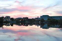
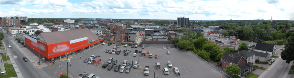
Downtown Peterborough at dusk in June 2009 | |||
| |||
| Nickname(s): "The Electric City", "Ptbo" | |||
|
Motto: Dat natura, elaborant artes (Nature Provides, Industry Develops) | |||
 Peterborough | |||
| Coordinates: 44°18′N 78°19′W / 44.300°N 78.317°WCoordinates: 44°18′N 78°19′W / 44.300°N 78.317°W | |||
| Country | Canada | ||
| Province | Ontario | ||
| County | Peterborough | ||
| Established | 1819: Scott's Plains | ||
| Incorporated as town | 1850: Peterborough | ||
| Incorporated as city | July 1, 1905 | ||
| Government | |||
| • Mayor | Daryl Bennett | ||
| • MP | Maryam Monsef (Liberal Party of Canada) | ||
| • MPP | Jeff Leal (OLP) | ||
| Area[1][2][3] | |||
| • Land | 63.80 km2 (24.63 sq mi) | ||
| • Urban | 70.82 km2 (27.34 sq mi) | ||
| • Metro | 1,506.90 km2 (581.82 sq mi) | ||
| Elevation | 195 m (640 ft) | ||
| Population (2011)[1][2][3] | |||
| • City (single-tier) | 78,698 (70th) | ||
| • Density | 1,233.6/km2 (3,195/sq mi) | ||
| • Urban | 80,660 | ||
| • Urban density | 1,059.6/km2 (2,744/sq mi) | ||
| • Metro | 123,270 (33rd) | ||
| • Metro density | 79.0/km2 (205/sq mi) | ||
| Time zone | Eastern (EST) (UTC-5) | ||
| • Summer (DST) | EDT (UTC-4) | ||
| Postal code span | K9H, K9J, K9K, K9L | ||
| Area code(s) | 705 & 249 | ||
| Highways |
| ||
| Website | www.peterborough.ca | ||
|
Pop. Change (2001–2006): 4.8% Dwellings: 33,042¹ ¹ According to the Canada 2006 Census | |||

Peterborough /ˈpiːtərbɔːroʊ/ PEE-tər-bur-oh is a city on the Otonabee River in Central Ontario, Canada, 125 kilometres (78 mi) northeast of Toronto. According to the 2011 Census, the population of the City of Peterborough was 78,698. The population of the Peterborough Census Metropolitan Area (CMA), which includes the surrounding Townships of Selwyn, Cavan Monaghan, Otonabee-South Monaghan, and Douro-Dummer, was estimated in 2014 at 123,270.[4] It presently has the 33rd largest CMA in Canada. The current mayor of Peterborough is Daryl Bennett.
Peterborough's nickname is "The Electric City" as it was the first town in Canada to use electric streetlights.[5] It also underscores the historical and present-day importance of technology and manufacturing as an economic base of the city, which has operations from large multi-national companies such as Siemens, Rolls Royce, and General Electric, and more local technology businesses such as Fisher Gauge and Bryston. Electricity was one of the reasons Quaker Oats moved to the city, and as part of PepsiCo, remains a major fixture in the downtown area to this day.
Peterborough is known as the gateway to the Kawarthas, "cottage country", a large recreational region of the province. It is named in honour of Peter Robinson, an early Canadian politician who oversaw the first major immigration to the area. The city is the seat of Peterborough County.[6]
History
Pre-European settlement era
First Nations groups probably entered into the area across Bering Sea, through Alaska, millennia ago (exact dates unknown). Woodland Natives inhabited the area circa 1000 BCE – 1000 CE, followed by Iroquois and Mississaugas circa 1740 CE. Two of the more prominent sites surviving from this time are the petroglyphs at Petroglyphs Provincial Park and Serpent Mounds. The petroglyphs are located northeast of Peterborough and are believed to have been carved by the Algonquin people between 900 and 1400 CE. The Serpent Mounds are located near Keene, approximately 30 km southeast of Peterborough in Otonabee-South Monaghan township, in an area first inhabited sometime before 10 CE.[7]
In 1615, Samuel de Champlain traveled through the area, coming down from Lake Chemong and portaging down a trail, which is approximated by present-day Chemong Road, to the Otonabee River[8] and stayed for a brief time near the present-day site of Bridgenorth, just north of Peterborough.
19th century
In 1818, Adam Scott settled on the west shore of the Otonabee River. The following year he began construction of a sawmill and gristmill, establishing the area as Scott's Plains. The mill was located at the foot of present-day King Street and was powered by water from Jackson Creek. This location, adjacent to the Ontario government Ministry of Natural Resources building, and Peterborough's Millennium Park may have been the site of landfall for a portage which connects in a direct line with Bridgenorth. The site has an Ojibway name "Nogojiwanong" which means "the place at the end of the rapids".
The year 1825 marked the arrival of Irish immigrants from the city of Cork to Scott's Plains. In 1822, the British Parliament had approved an experimental emigration plan to transport poor Irish Catholic families to Upper Canada.
Peter Robinson, a member of the Legislative Assembly of Upper Canada and a prominent businessman from York, Upper Canada was the man who took on the emigration plan of 1825. Scott's Plains was renamed Peterborough in his honour. Robinson interviewed families and individual males to make the long voyage. These families had to meet specific criteria in order to be eligible for the voyage. The specifics required for Robinson's settlers were that they had to be Catholic, poor and with a knowledge of farming. Males had to be less than forty-five years of age and in good health and families were unrelated. The majority of the Irish emigrants were chosen from Fermoy, North Cork.[9]
Robinson was urged by landlords to remove the "pauper and undesirables". He resisted and stated that he had "no wish...to hold out a bounty to persons of bad character...but as Robinson traveled through the countryside they became flesh and blood 'people of a good sort' he called them, 'bred to farming...I found them much more intelligent than I expected. Most of them could read and write'".[10]
Thomas Poole, a nineteenth century writer, wrote that all 2024 passengers boarded nine ships in June 1825, with everything they owned, from Cork across the Atlantic Ocean to Quebec City. The journey took 30 days to cross the Atlantic and on board the ship they were provided with bunks and food rations. Hard tack or ship biscuits were one of the many foods that were made to provide energy for the passengers. Hard tack was very easy to make and could be stored for months without spoiling. After the settlers landed in Quebec City they traveled further down the St-Lawrence River eventually reaching Lachine where they boarded a bateau. Heading west to Kingston and ultimately to Kingston and Cobourg. They camped in tents in Cobourg for several weeks until Peter Robinson joined them to lead them up to their final destination. The long voyage across the ocean was enough to weaken the emigrants but having to camp out in tents in the mid-summer heat brought on several other complications. Nearly all of the settlers experienced fever and ague, and several perished from it. Even faced with these hardships they forged ahead and put their trust in Peter Robinson, the man leading them to their settlement in Peterborough.[11]
In 1845, Sandford Fleming, inventor of Standard Time and designer of Canada's first postage stamp, moved to the city to live with Dr. John Hutchison and his family, staying until 1847. Dr. John Hutchison was one of Peterborough's first resident doctors.
Peterborough 1850 was incorporated as a town, with a population of 2,191.
Beginning in the late 1850s, a substantial canoe building industry grew up in and around Peterborough. The Peterborough Canoe Company was founded in 1893, with the factory being built on the site of the original Adam Scott mill. By 1930, 25% of all employees in the boat building industry in Canada worked in the Peterborough area.[12]
Peterborough would also see extensive industrial growth as the city was one of the first places in the country to begin generating hydro electrical power (even before the plants at Niagara Falls). Companies like Edison General Electric Company (later Canadian General Electric) and America Cereal Company (later to become Quaker Oats, and in 2001 PepsiCo, Inc.), opened to take advantage of this new cheap resource.
20th century and onwards
The first major events of the 20th Century in Peterborough occurred in 1904.The first occurrence was the completion of the Peterborough Lift Lock on July 9, eight years after construction was initially approved. To this day, many landmarks in Peterborough memorialise Richard Rogers, conceptual father of the Lift Lock, such as Rogers Cove on Little Lake and Rogers Street in the eastern part of the city.
In 1905, Peterborough was incorporated as a city on Dominion Day, with a population of about 14,300. The city's flag and coat of arms were adopted later, in 1951.
In the 1970s, the Ontario Government helped sponsor the building of Peterborough Square with the aid of the Ontario Downtown Renewal Programme (ODRP). The mall was anchored by an Eaton's store until the collapse of the Eaton's chain of stores in the late 1990s; it now houses offices, stores and a food court. The provincial government relocated the central office of the Ministry of Natural Resources to 300 Water Street, kitty corner from Peterborough Square. With two post-secondary educational institutions, Trent University and Fleming College, the region has a wealth of research and labour development opportunities. On top of all of the advantageous economic and market-access factors Peterborough is located in one of Canada's premier lake districts—the Kawarthas—providing sport, recreation and lifestyle opportunities. In 2008, a new regional hospital officially opened in Peterborough.
Geography
Peterborough is situated in Central Ontario within the Kawartha Lakes region in Ontario. Peterborough lies in the St. Lawrence Lowlands ecoregion, just south of the Canadian Shield and approximately 35 kilometres north of Lake Ontario. The city is sited on a series of rapids in the Otonabee River, approximately halfway between the river's source (Katchewanooka Lake) and its mouth (Rice Lake). The City completely surrounds the only lake on the Otonabee, Little Lake, and the Trent Canal runs along the eastern edge of the city, connecting Little Lake to a section of the Otonabee above the rapids.
Topography
Peterborough's topography is largely defined by land formations created by the receding Wisconsian glaciers 10,000-15,000 years ago. The South End and Downtown portions of the City sit on what was the bottom of the glacial Lake Peterborough - part of a glacial spillway created when glacial meltwaters from ancient Lake Algonquin (now Lake Huron) traveled south to ancient Lake Iroquois (now Lake Ontario). This area of relatively low and flat relief (approximately 191–200 m (627–656 ft) above sea level) is prone to flooding, exemplified in the major flood that occurred on July 15, 2004. The ground elevation rises to the west, north, and east where a large upland area (the Peterborough Drumlin field) defines the landscape. Much of the land in the North and West Ends of the City rises to 230–274 metres (755–899 ft) above sea level, with Tower Hill, at 286 m (938 ft) a.s.l., being the highest point in the City. Armour Hill, another prominent drumlin located in East City, forms the physical obstacle which the Trent-Severn Waterway ascends by way of the Peterborough Lift Lock. The Oak Ridges Moraine is located approximately 15 kilometres south of the city.
Climate
Peterborough has a humid continental climate (Köppen climate classification Dfb) with four distinct seasons. It lies in a transitional zone between areas to the south, which have a milder winter climate, and areas to the north (within the Canadian Shield), where the winters are snowier and sharply colder. Peterborough's Hardiness zone is 5b.[13] Peterborough's climate can be quite unpredictable and vary greatly from one part of the City to another due to the effects of the Oak Ridges Moraine and changes in elevation. In the South End and areas south of the City, the Moraine acts as a barrier for weather patterns moving off Lake Ontario, reducing precipitation. In the North and West Ends of Peterborough the effects of the Moraine are not as prominent, at times creating slightly cooler temperatures and more precipitation than the more southern parts of the City and County.
The highest temperature ever recorded in Peterborough was 102 °F (38.9 °C) on 11 July 1936.[14] The coldest temperature ever recorded was −39 °F (−39.4 °C) on 21 December 1871.[15]
| Climate data for Peterborough (Trent University), 1981−2010 normals, extremes 1866−present[lower-alpha 1] | |||||||||||||
|---|---|---|---|---|---|---|---|---|---|---|---|---|---|
| Month | Jan | Feb | Mar | Apr | May | Jun | Jul | Aug | Sep | Oct | Nov | Dec | Year |
| Record high °C (°F) | 14.4 (57.9) |
13.9 (57) |
26.0 (78.8) |
30.5 (86.9) |
35.0 (95) |
36.7 (98.1) |
38.9 (102) |
37.2 (99) |
37.2 (99) |
30.6 (87.1) |
23.9 (75) |
18.5 (65.3) |
38.9 (102) |
| Average high °C (°F) | −3.7 (25.3) |
−1.5 (29.3) |
3.7 (38.7) |
11.7 (53.1) |
18.7 (65.7) |
24.0 (75.2) |
26.8 (80.2) |
25.4 (77.7) |
20.6 (69.1) |
13.4 (56.1) |
6.3 (43.3) |
0.0 (32) |
12.1 (53.8) |
| Daily mean °C (°F) | −8.4 (16.9) |
−6.5 (20.3) |
−1.3 (29.7) |
6.3 (43.3) |
12.8 (55) |
18.0 (64.4) |
20.7 (69.3) |
19.4 (66.9) |
15.0 (59) |
8.4 (47.1) |
2.4 (36.3) |
−4.0 (24.8) |
6.9 (44.4) |
| Average low °C (°F) | −13.0 (8.6) |
−11.4 (11.5) |
−6.4 (20.5) |
0.8 (33.4) |
6.8 (44.2) |
11.9 (53.4) |
14.6 (58.3) |
13.3 (55.9) |
9.4 (48.9) |
3.4 (38.1) |
−1.5 (29.3) |
−7.9 (17.8) |
1.7 (35.1) |
| Record low °C (°F) | −37.8 (−36) |
−38.9 (−38) |
−31.1 (−24) |
−20.0 (−4) |
−7.8 (18) |
−1.7 (28.9) |
2.2 (36) |
−2.8 (27) |
−7.8 (18) |
−14.4 (6.1) |
−23.9 (−11) |
−39.4 (−38.9) |
−39.4 (−38.9) |
| Average precipitation mm (inches) | 57.3 (2.256) |
48.8 (1.921) |
56.5 (2.224) |
66.4 (2.614) |
88.7 (3.492) |
83.0 (3.268) |
73.6 (2.898) |
87.0 (3.425) |
92.4 (3.638) |
77.0 (3.031) |
85.5 (3.366) |
66.0 (2.598) |
882.1 (34.728) |
| Average rainfall mm (inches) | 22.4 (0.882) |
23.1 (0.909) |
34.0 (1.339) |
60.9 (2.398) |
88.7 (3.492) |
83.0 (3.268) |
73.6 (2.898) |
87.0 (3.425) |
92.4 (3.638) |
75.7 (2.98) |
73.3 (2.886) |
35.0 (1.378) |
749.0 (29.488) |
| Average snowfall cm (inches) | 38.9 (15.31) |
28.8 (11.34) |
23.7 (9.33) |
6.1 (2.4) |
0.0 (0) |
0.0 (0) |
0.0 (0) |
0.0 (0) |
0.0 (0) |
1.4 (0.55) |
13.9 (5.47) |
34.3 (13.5) |
147.2 (57.95) |
| Average precipitation days (≥ 0.2 mm) | 14.0 | 9.3 | 11.3 | 12.0 | 12.8 | 11.2 | 10.1 | 11.4 | 11.8 | 14.3 | 14.2 | 12.8 | 145.2 |
| Average rainy days (≥ 0.2 mm) | 3.8 | 3.8 | 6.5 | 11.0 | 12.8 | 11.2 | 10.1 | 11.4 | 11.8 | 14.2 | 11.2 | 5.7 | 113.6 |
| Average snowy days (≥ 0.2 cm) | 11.0 | 6.6 | 5.8 | 2.0 | 0.0 | 0.0 | 0.0 | 0.0 | 0.0 | 0.23 | 3.8 | 8.2 | 37.6 |
| Mean monthly sunshine hours | 87.9 | 114.4 | 143.5 | 175.5 | 217.8 | 268.4 | 294.9 | 247.9 | 170.2 | 132.7 | 76.7 | 69.2 | 1,999.1 |
| Percent possible sunshine | 30.6 | 38.9 | 38.9 | 43.5 | 47.6 | 57.9 | 62.7 | 57.1 | 45.2 | 38.9 | 26.5 | 25.0 | 42.7 |
| Source: Environment Canada[14][15][16][17][18] | |||||||||||||
Significant weather events
In 2004, Peterborough experienced a flood which caused much damage for the city and surrounding areas. On July 14, 2004, the sewage treatment plant recorded 7 million gallons of water as opposed to the average 1.3 million gallons average. The city recorded 12,500 metric tonnes of debris added to landfills due to the amount of damage caused by excessive rain and wind.[19]
Demographics
| Historical populations | ||
|---|---|---|
| Year | Pop. | ±% |
| 1841 | 2,000 | — |
| 1851 | 2,191 | +9.5% |
| 1871 | 4,611 | +110.5% |
| 1881 | 6,812 | +47.7% |
| 1891 | 9,717 | +42.6% |
| 1901 | 11,239 | +15.7% |
| 1911 | 18,360 | +63.4% |
| 1921 | 20,994 | +14.3% |
| 1931 | 22,372 | +6.6% |
| 1941 | 24,977 | +11.6% |
| 1951 | 38,272 | +53.2% |
| 1961 | 47,185 | +23.3% |
| 1971 | 58,111 | +23.2% |
| 1981 | 60,620 | +4.3% |
| 1991 | 68,371 | +12.8% |
| 1996 | 69,742 | +2.0% |
| 2001 | 71,446 | +2.4% |
| 2006 | 74,898 | +4.8% |
| 2011 | 78,698 | +5.1% |
| Canada 2006 Census | Population | % of Total Population | |
|---|---|---|---|
| Visible minority group Source:[20] | South Asian | 555 | 0.8% |
| Chinese | 685 | 0.9% | |
| Black | 440 | 0.6% | |
| Filipino | 70 | 0.1% | |
| Latin American | 215 | 0.3% | |
| Arab | 50 | 0.1% | |
| Southeast Asian | 145 | 0.2% | |
| West Asian | 100 | 0.1% | |
| Korean | 255 | 0.3% | |
| Japanese | 45 | 0.1% | |
| Other visible minority | 35 | 0% | |
| Mixed visible minority | 30 | 0% | |
| Total visible minority population | 2,625 | 3.6% | |
| Aboriginal group Source:[21] | First Nations | 960 | 1.3% |
| Métis | 590 | 0.8% | |
| Inuit | 25 | 0% | |
| Total Aboriginal population | 1,690 | 2.3% | |
| White | 69,495 | 94.2% | |
| Total population | 73,810 | 100% | |
As of the Canada 2011 Census, there were 78,698 people and 35,698 dwellings in the city. This is an increase from 74,898 residents as at the Canada 2006 Census, a growth rate of 5.1%. This is less than both Ontario's overall growth rate (5.7%) and Canada's growth rate (5.9%).[22] The population density of the city is 1,233.6 people per square kilometre.
The population of Peterborough's CMA, which consists of the city of Peterborough as well as the surrounding townships of Smith-Ennismore-Lakefield, Douro-Dummer, Otonabee-South Monaghan and Cavan-Monaghan; stood at 118,975 in 2011. This makes it the 33rd largest metropolitan area in Canada (14th in Ontario). The population increased from 116,570 in 2006 for a growth rate of 2.1%. Communities within Peterborough's CMA include Millbrook, Bridgenorth and Lakefield. The population density of Peterborough (CMA) averaged 85.4 people per square kilometre, compared with an average of 12.6 people per square kilometre (32.6/sq mi) for the province. A 2014 estimate released by Statistics Canada shows the Peterborough CMA having a population of 123,270.[4]
In 2006, the resident population 14 years or younger made up 15.7% of the general population, while 18.2% were 65 or older. The median age for the CMA was 42.8, which is the fifth highest of Canada's thirty-three Census Metropolitan Areas, behind Trois-Rivières, Saguenay, Kelowna and Victoria.[23]
Peterborough's population is predominantly white, with only 3.1% of the population identifying as Aboriginal[24] and 2.7% identifying as a visible minority;[25] made up of 0.6% South Asian, 0.6% Chinese, 0.5% Black, 0.1% Filipino, 0.2% Latin American and 0.2% Southeast Asian. Peterborough is also primarily an English-speaking city, with 92.5% of the population speaking it as their mother tongue. French is spoken by 1.1% of the population, and other languages are spoken by 5.9% of the population.[26]
Economy
| Top Eight Major Employers[27] | |||||
|---|---|---|---|---|---|
| Employer | Employment Numbers | ||||
| Peterborough Regional Health Centre | 2075 | ||||
| Kawartha Pine Ridge District School Board | 2050 | ||||
| Fleming College | 1700 | ||||
| General Electric | 1500 | ||||
| City of Peterborough | 900 | ||||
| Ministry of Natural Resources | 895 | ||||
| Trent University | 700 | ||||
| PepsiCo Foods (Quaker) | 700 | ||||

No longer the dominant local industry, manufacturing is still one of the key sectors along with food processing, automotive supplies, electronics, aerospace and life sciences/biotechnology. General Electric and Quaker Oats maintain large operations in Peterborough, as well, the city is also a 'bedroom' community for workers commuting to Oshawa and East Toronto. The Peterborough Regional Health Centre is the largest employer, with about 2,000 employees.[28] School boards, local government, Trent University and the Ontario Ministry of Natural Resources are other large employers.
Companies like General Electric have had a major impact on the growth of the city. The North American Free Trade Agreement (NAFTA) of the early 1990s saw a major shift in trading patterns for many Canadian companies. Other innovations like just in time delivery and pressure to produce ever cheaper goods impacted some of the large multi-nationals in the 1970s and 1980s. GE operations in Peterborough consists of GE Hitachi Nuclear Energy Canada and GE Power Conversion. Despite this, today GE, PepsiCo Quaker, Siemens and numerous smaller manufacturing companies are experiencing significant growth. Minute Maid (Coca-Cola) recently invested $CDN20 million in a new warehouse and product line while auto parts supplier Ventra has doubled in size. United Canadian Malt Ltd. is a manufacturer of a wide variety of extracts of malted barley, and other grains.[29] Manufacturing job creation kept pace with the provincial average from 1991–2001. Lower costs, reliable labour and high quality post-secondary institutions are a competitive advantage for Peterborough. Peterborough was ranked number one location for business in Ontario by Canadian Business magazine in late 2004.
However, in the past ten years the city's economy has struggled with unemployment. Its unemployment rate often leads the country for census metropolitan areas in Canada.[30][31][32]
Peterborough is a major shopping destination for the region and is home to three shopping centres; Peterborough Square, located at George and Simcoe Streets, Portage Place at 1154 Chemong Road, and Lansdowne Place at 645 Lansdowne Street West. All have undergone major renovations in recent years. Walmart, Costco and Real Canadian Superstore have large stores in Peterborough, which draw clients from the surrounding area.
Arts and culture
Artspace is one of Canada's oldest artist-run art centres, founded in 1974. Its mandate is to support the growth and development of contemporary artists. Artspace maintains a public gallery. Noted artist David Bierk was one of the founding members.

The Art Gallery of Peterborough was also founded in 1974 and features rotating exhibitions by local, national, and international artists.
Peterborough is also home of the Kawartha Artists Gallery, a group of amateur artists. Formed in 1991, under the leadership of Monica Jackson, the KAGS meets in the basement of the De La Fosse Library in Peterborough's south end. A variety of artists meet there: Weavers, Monday mornings; Life Drawing, Tuesday mornings; Still Life, Wednesday mornings; Portrait, Wednesday afternoons (September–June); and Outdoor Artists, Thursday mornings (indoors October–April). There are a number of single artist and multi-member exhibits in paint (abstract and representational), various media and photography.
Peterborough New Dance and Public Energy was founded by Bill Kimball in 1994, and is a presenter and animator of contemporary dance and performance. It is the only full-time presenter of contemporary dance in Ontario outside of Toronto and Ottawa. The organization also supports the development of local dance and performance artists, produces the annual Emergency festival of new dance featuring area artists, and presents indigenous performing artists.
The Peterborough Symphony Orchestra (PSO) was incorporated in 1967, with historical roots reaching back before the turn of the century. The PSO presents symphonic music. Music Director Michael Newnham has led the organization since 2001, which offers concerts and educational outreach programming to Peterborough and beyond.
The Peterborough Singers is a choir whose membership originally formed within the scope of the Peterborough Symphony Orchestra in 1990 and was known as the "Peterborough Symphony Singers." However, in 1993, the Peterborough Singers (PS) was incorporated as a stand-alone entity. Under the direction of Sydney Birrell and a dedicated group of volunteers, the choir has grown into an ensemble of 90 to 100 members.
The Peterborough Folk Festival was founded in 1989 by a collective of artists; this three-day August festival has supported a number of local and Canadian artists. Its Emerging Artist Award, founded in 2001 by Reverend Ken Ramsden, has honoured Serena Ryder and Sean Conway.
The Starfire Band was originally formed in 1999 by Peter Ford. It was an offshoot of the Kawartha Wind Symphony, which was composed of the older generation of musicians. The Starfire Band was created for the younger generation of musicians and consists of students from Grade 7 to Grade 12 in the Peterborough area who are interested in music, not necessarily with any or much experience.
Peterborough has a resident professional theatre company; New Stages. Founded in 1997 by Randy Read, New Stages produces new Canadian and American plays, and runs a reading series of non-traditional work. New Stages is a fully equity company and uses both Showplace Peterborough and the Market Hall Performing Arts Centre.
Peterborough also maintains an improvisational comedy scene. The monthly Impros vs. Joes show brought in talent from the Greater Toronto Area and beyond. Linda Kash operates a small theatre school in the area with a focus on improv for young people. The Citiots[33] currently perform a monthly show for local audiences at the Gordon Best Theatre in the downtown.
Peterborough is also known for its music scene, and is home to musicians and bands such as Hawk Nelson, I Mother Earth, The Spades, Thousand Foot Krutch, Jimmy Bowskill, The Burning Hell, Three Days Grace, Big Damn Heroes and My Darkest Days.
Attractions
Peterborough and the Kawarthas offer several attractions. The region is host to an array of museums, cultural exhibitions, indoor and outdoor galleries and theatres, Aboriginal heritage attractions and historical sites, as well as an arts community.
While many buildings in Peterborough that would have served as examples of the cities heritage and architectural style have been lost over the years due to renovations and modernizations, some examples such as the YMCA building do still stand today as designated architectural landmarks.[34]
Peterborough is home to Canada's only authentic Venetian gondola service. Honeymoon Gondola offering romantic gondola rides to lovers in Little Lake at the Peterborough Marina.
The Peterborough Museum & Archives is home to a diverse collection of artifacts. It was established in 1897 and moved to its present site on Armour Hill in 1967. The Archives collection includes items from Catharine Parr Traill, the original Peter Robinson papers, the Park Studio Fonds and the Balsillie collection of Roy Studio Images, over 300,000 film and glass plate negatives dating back to 1896.
Walter Seymour Allward designed a municipal cenotaph, the Peterborough Memorial (1929), Valour Defeating Barbarism.[35]
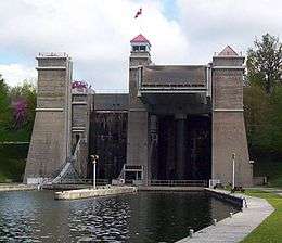
The Trent-Severn Waterway passes through Peterborough and includes the Peterborough Lift Lock, the world's largest hydraulic lift lock, which opened in 1904. It is also the world's highest hydraulic lift lock with a rise of 65 feet (20 m).
Del Crary Park is a large urban greenspace on Little Lake, located in close proximity to downtown Peterborough. Free outdoor events and concerts are held here during the summer months, including the international Peterborough Musicfest (formerly Festival of Lights & Little Lake Musicfest), Wednesday and Saturday evenings from June through August. The Art Gallery of Peterborough, opened in 1974, is situated on the shore of Little Lake beside Del Crary Park and features 1,300 pieces from around the world.
On Little Lake, there is a fountain called Centennial Fountain that runs from May to October yearly. This fountain has lights that are put on at dusk and is considered a local and tourist attraction.[36]
Peterborough offers a cruise type sightseeing option called Liftlock and River Boat Cruise. This cruise boat takes passengers through the Peterborough Liftlock while broadcasting various facts about the city's sights and history. The cruise operates daily from mid-May to mid-October every year.[37]
Showplace Performance Centre is a 647-seat performance facility located downtown that opened in 1996. The Canadian Canoe Museum, located on Monaghan Road, is a national heritage centre that explores the canoe's enduring significance to the peoples of North America.
Jackson Park contains old-growth forest with trees up to 250 years old.[38] The 4.5 ha old-growth forest can be visited from the parking area at the north end of Monaghan Rd.
The Riverview Park & Zoo is a 55.5-acre (22.5 ha) zoo operated by the Peterborough Utilities Group at the North end of Water Street. In addition to its animal exhibits, the zoo features a miniature train ride and the park contains a disc golf course.
The Peterborough Skateboard park is one of the largest skateboard parks in Ontario. It includes several half-pipes as well as multiple ramps and rails. Its construction was sponsored by West 49.
The 'Wall Of Honour' monument was recently unveiled in Confederation Park across from City Hall on North George Street. It contains the names of the 11,300 servicemen and women from the Peterborough area who served in Canada's Armed Forces in World War I, World War II and the Korean War.
Peterborough also contains Wild Water & Wheels Amusement Park containing the worlds only operating auto sled coaster.
Downtown
Peterborough's downtown is home to locally owned shops and restaurants[39] including music stores, fine dining and jewelry stores.
Sports and recreation

Peterborough has many sports and recreational opportunities.
Peterborough's junior level hockey team, the Peterborough Petes of the Ontario Hockey League, were established in 1956 and have become the longest continuously operating team in the league.[40] They have participated in the Memorial Cup tournament nine times in their history and won it once. The Petes have produced a record number of National Hockey League (NHL) players such as Eric Staal, Jordan Staal, Mike Fisher, Cory Stillman, Chris Pronger, Steve Yzerman, Bob Gainey, Mike Ricci, Larry Murphy, Tie Domi, Mickey Redmond, and coaches such as Scotty Bowman, Roger Neilson, Mike Keenan, Gary Green and Dick Todd. They have also graduated 96 players who have played 100 or more games in the NHL.[41]
The Peterborough Memorial Centre, constructed in 1956, is the home of the Peterborough Petes as well as the Peterborough Lakers and was named in honour of the many war veterans who came from the region. It is located at the east of the exhibition grounds at the corner of Lansdowne and George Streets. In 2003, the Memorial Centre was renovated adding 24 box suites, improved concessions, a licensed restaurant, new seats, boards, scoreboard and air conditioning.
The city carries a Tier II Junior "A" team known as the Peterborough Stars that play in the Ontario Provincial Junior A Hockey League. The city also has a youth women's hockey team called the Peterborough Ice Kats. Box lacrosse is also popular in the area. Teams include the Major Series Lacrosse Peterborough Sr. A Lakers and the Peterborough Jr. Lakers, who hold a Junior A record of 12 Canadian Minto Cup Championships.
A portion of the Trent-Severn Canal below the lift lock is flooded and maintained for skating each winter.
Peterborough also participated in a biennial Olympics-like competition with sister city Ann Arbor, Michigan: the Arborough Games were held every two years (rotating between the cities) starting in 1982. It ended, due to a lack of volunteers, after the 2000 edition.
Peterborough is home to a rowing club with programs for learning to row, recreational rowing, as well as competitive regattas. This club is home to Trent University Rowing as well as hosts many secondary school teams in the area. This club was established in 1977 and is located along the shores of the Otonabee River in the north end of the city.[42]
Beavermead Campground is located on Little Lake at the center of Peterborough. Beavermead Campground has 98 individual campsites, 46 un-serviced and 52 serviced. Beavermead has rental options for kayaks and a supervised swimming area. There are multiple athletic fields and public washrooms on the grounds.[43] Beavermead Park hosts the Soul Beach Volleyball program that facilitates games and recreation during the summer months.[44]
Peterborough is home to The Rotary Greenway Trail, a 20 km stretch of trail with benches, historic, environmental and ecological signage. The Jackson Creek Kiwanis trail is a 4 km stretch of the Trans-Canada Trail located in Jackson Park. The Parkway Trail travels 4.2 km between Jackson Park and Riverview Park and Zoo.[45]
PYSC (The Peterborough Youth Soccer Club) offers recreational and competitive soccer for children ages 4 to 18.[46]
Government

Peterborough is a single-tier municipality governed by a mayor-council system. The Mayor of Peterborough is elected by direct popular vote to serve as the chief executive of the city. The Peterborough, Ontario City Council is a unicameral legislative body, comprising the Mayor and ten city councillors representing five geographical wards of the city. The present wards are as follows;
| Otonabee Ward | Dan McWilliams and Lesley Parnell | ||||
| Monaghan Ward | Henry Clarke and Don Vassiliadis | ||||
| Town Ward | Dean Pappas and Diane Therrien | ||||
| Ashburnham Ward | Keith Riel and Gary Baldwin | ||||
| Northcrest Ward | Andrew Beamer and Dave Haacke |
Peterborough City Hall at 500 George Street North in downtown Peterborough and also houses the central offices of Peterborough Social Services. The municipal budget for 2008 for the city is projected to be $190.9 million, an increase from 2007's actual expenditures of $185.4 million, or 2.9%.[47]
Prior to the city being separated from it, the city was also the seat of Peterborough County. The Peterborough County Court House is located at 470 Water Street and was built between the years of 1838 and 1840[48] and still holds a portion of the county's offices.
At the provincial level, the riding is held by Jeff Leal, MPP, of the Ontario Liberal Party, who has held it since the 2003 Ontario election.
In 2014, MP Dean Del Mastro was found guilty of overspending on his 2008 election campaign. This trial and guilty verdict led to his resignation.[49]
Crime
Peterborough had the sixth lowest crime severity rate in 2013 out of Canada's 34 census metropolitan areas, according to Statistics Canada. Peterborough's crime severity index of 54.4 is a 14% reduction compared to the 2012 rate.
Only Toronto, Ottawa, Quebec City, Barrie and Guelph had lower crime severity indexes, according to the survey. None of the census metropolitan areas had increases in crime severity in 2013.
Peterborough's crime rate in 2013 was 4,489 crimes per 100,000 people, a 3% reduction from 2012, according to Statistics Canada. That was the 19th highest crime rate out of Canada's 34 census metropolitan areas.
The crime severity index is calculated by Statistics Canada and takes into account both the volume and severity, based on average sentences for offenders, of police-reported crime in Canada. Nationally the CSI was down 9% in 2013 compared to 2012 and is 36% lower than 10 years ago.
Peterborough's CMA includes the city and four surrounding townships.[50][51]
In 2011, Peterborough had the highest rate of hate crimes reported in Canadian cities.[52] However, in recent years Peterborough has been found to have a relatively low crime rate.
In November 2015, Peterborough gained nationwide notoriety after an arson took place at the Masjid Al-Salaam mosque. The resulting community response raised over $110,000 for repairs in less than two days[53] The mosque has since been rebuilt and reopened.[54]
Infrastructure
Roads and highways
Peterborough is served by provincial Highway 115, a freeway which connects the city to Toronto via Highway 401 and the soon-to-be constructed Highway 407 East. Provincial Highway 7, part of the Trans-Canada Highway, connects to Lindsay heading west and eventually to Ottawa heading east. Other Provincial Highways important to Peterborough are Highway 7A, which junctions onto Highway 115 just southwest of the city, and Highway 28, which routes from Highway 7 just east of the city to Lakefield and on further north.
The area is also served by numerous county roads.
There are four road bridges which cross the Otonabee River within the city limits of Peterborough. The most northerly one is the Nassau Mills Road Bridge near Trent University. The next most northerly bridge is the Parkhill Road Bridge. The Hunter Street Bridge crosses the river just north of Little Lake, linking East City with the downtown core. The most southerly bridge is the Lansdowne Street Bridge. In addition, Highway 115 crosses the river near the southern edge of the city. There are also numerous other bridges which cross the Trent Canal (notably the crossing at the lift lock which actually passes under the canal), Jackson Creek and the other minor creeks in the city. There are also numerous other river crossings throughout the CMA, the longest of which is the James A. Gifford Causeway, which crosses Chemong Lake linking Bridgenorth with Ennismore.
Public transit in the city of Peterborough is currently run by Peterborough Transit, providing a total of 12 regular and 5 express routes throughout the city.
Peterborough Transit's hub is a central terminal located on Simcoe Street in the city's downtown core. It also serves as the regional terminus for Coach Canada (formerly Trentway Wagar) routes into the city. Greyhound Lines of Canada operates an inter-city terminal nearby at the corner of Simcoe and Aylmer Streets, with several daily commuter buses to and from Toronto. GO Transit established a bus service from Peterborough to Oshawa starting September 5, 2009.
Railways
Peterborough | |
|---|---|
 Heritage railway station building | |
| Location |
175, George Street North Peterborough, Ontario Canada |
| Coordinates | 44°17′56″N 78°19′12″W / 44.29889°N 78.32000°W |
| Line(s) | Havelock Subdivision |
| Construction | |
| Architect | Thomas Charles Sorby |
| History | |
| Opened | 29 October 1884 |
| Closed | 1 January 1990 |
| Official name | Peterborough CPR Station |
| Designated | 2006 |
| Reference no. | 4400 |
Peterborough is served by Canadian Pacific Railway. No passenger services currently exist, but the federal government plans to reinstate them although little significant progress has been made. Dean Del Mastro, MP, lobbied for passenger rail to be brought back to the small city, and there has been government funding put aside for a Peterborough–Toronto rail link however as of 2014 there had been no significant progress.[55]
The Peterborough railway Station is historically significant for its association with the early development of the Canadian Pacific Railway, and its predecessor the Ontario and Quebec Railway.[56]
Air and water transportation
Peterborough Airport is located off Highway 115, just south of the city. It is primarily a recreation and business airport, offering no scheduled flights by any airlines. It has two runways, a 1782-foot turf runway and a 7000-foot asphalt runway. The airport services approximately 25,000 - 30,000 aircraft movements per year.[57]
Otonabee River and Trent Canal is part of the Trent-Severn Waterway, providing a link from Lake Ontario to Lake Huron. The canal runs through the very eastern portion of the city and is home to the Peterborough Lift Lock, the highest hydraulic boat lift in the world. The Peterborough Marina is located on Little Lake near where Jackson Creek drains into the lake, beside Del Crary Park and just east of George Street. It contains 90 slips for docking and a host of amenities.[58]
Utilities
Peterborough is served by the Peterborough Utilities Group (PUG), formerly the Peterborough Utilities Commission, which provides electricity and water to the city and its residents. It is currently 100%-owned by the City of Peterborough. They have been in operation for over 90 years. The PUG has recently started expanding outside of just distributing water and electricity within the city and have begun to develop and operate electricity generation (notably the 8 MW Trent Rapids hydroelectric project (2010) and the 10MW Lily Lake Solar Farm (2011), which capitalizes on the Province of Ontario's feed-in tariff program), telecom services, energy equipment rentals, and commercial metering services both in Peterborough and throughout the province.[59] Natural gas for heating is provided locally by Enbridge Inc.
Healthcare
Peterborough is home to the Peterborough Regional Health Centre (PRHC), which serves Peterborough, Peterborough County, Northumberland County, the City of Kawartha Lakes, Haliburton County and Hastings County. It is located at 1 Hospital Drive and prior to the completion of its new facility in June 2008, also provided some services from the old St. Joseph's site at 384 Rogers Street. The PRHC is part of the Central East Local Health Integration Network, provides 400 beds and houses one of the busiest emergency departments in Ontario.[28][60] Peterborough is home to four methadone clinics and many centres for addiction treatment and counselling.[61]
Education
- See also the category Schools in Peterborough, Ontario
School boards in Peterborough
The Kawartha Pine Ridge District School Board (KPRDSB) is the public English language school board that serves the local area. Its headquarters are located at 1994 Fisher Drive, Peterborough. Over 35,000 students attend its schools and it encompasses almost 7,000 square kilometres,[62] and takes the place of the former Peterborough County Board of Education and Northumberland-Clarington Board of Education. It stretches from the north of Peterborough County south to Lake Ontario, and from Hastings County in the east, to the City of Kawartha Lakes and the City of Oshawa in the west. As of 2010, the KPRDSB operates 82 elementary schools, 15 secondary schools and four adult learning centres serving both the urban area and the outlying rural communities. Of those, 16 elementary schools, five secondary schools and a single adult learning centre are located within the city. The Kawartha Pine Ridge District School Board is home to a French Immersion program[63] where students learn French and English through elementary and secondary school. In Peterborough, there are four elementary schools and one high school that hosts this program.
The Peterborough Victoria Northumberland and Clarington Catholic District School Board is the Separate English language school board for the region. It is headquartered at 1355 Lansdowne Street West, Peterborough and presently operates 33 elementary schools and five secondary schools. Of these, nine elementary and two secondary schools operate within the city.
The Conseil scolaire de district catholique Centre-Sud is the Separate French language school board for the South-Central region of Ontario, which includes Peterborough. It presently operates 41 elementary schools and eight secondary schools, of which the only school in Peterborough is the elementary school Monseigneur-Jamot.
Post-secondary institutions
Trent University
Established in 1964, Trent University is a small liberal arts- and science-oriented institution. Trent's academic focus is on environmental, cultural and science studies. The main Symons Campus of Trent, located in the city's far north end, is approximately 14.6 square kilometres, over half of which is a part of Trent's Nature Areas, an ecologically diverse wild-life nature reserve.
Trent University is divided into a series of colleges: Champlain, Lady Eaton, Catharine Parr Traill, Otonabee, Peter Gzowski and Julian Blackburn. Each college has its own residence hall, dining room and student government, except for Catharine Parr Traill which consists only of part-time students and is located near downtown Peterborough and Julian Blackburn which is mostly administrative.
Fleming College
Established in 1967, Fleming College, (formerly Sir Sandford Fleming College), is a multidisciplinary institution with two primary campuses within the city of Peterborough:
McRae Campus is located in a renovated textile mill located on McDonnel Street near Monaghan Road and is home to the School of Continuing Education and Skilled Trades.
Sutherland Campus is located on Brealey Drive in the city's west end, and has recently undergone a massive expansion. The new St. Joseph's at Fleming is the first long-term care facility to be built on a college or university campus. In 2005, the Peterborough Sport & Wellness Centre was constructed to accommodate the college's athletic needs.
The college also operates satellite campuses in nearby Lindsay, Cobourg and Haliburton.
Kawartha Lakes Bible College
Kawartha Lakes Bible College (KLBC) is a small evangelical Bible college affiliated with the Plymouth Brethren. The school opened in 1973, and moved to its current location in 2001.
Master's College and Seminary
Master's College and Seminary is a Pentecostal Christian institution of higher education that consists of an on campus Bible College, a church-based Seminary, and a global distance education program. The school has partnerships with Trent University and Tyndale University College and Seminary of Toronto.
Public library system
The Peterborough Mechanics Institute, established in 1868, housed a subscription library that allowed members who paid a fee to borrow books. Mechanics Institutes were established across Ontario to make education universal and accessible to all citizens. In Peterborough, the Institute and the Library were located on Water Street. In May 1895, the Mechanics Institute became the Peterborough Public Library. The library remained on Water Street.
Later, the Peterborough Public Library received funding from the Andrew Carnegie Foundation and the new Carnegie Library located on George Street opened in 1911. This building is currently the Carnegie Wing of City Hall.
In February 1949, a branch library opened in the south end of Peterborough. It was situated above a hardware store and was a room 50 by 20 feet. It was divided into two sections—one for children, the other for adults.
The DelaFosse Branch Library opened officially on December 1, 1965. The Peterborough Examiner declared that this branch at 729 Park Street S., made "south end residents the envy of the rest of the city." Currently, it holds a recreational reading collection of approximately 14,000 hardcover and paperback books for all ages. Recent additions to the collection include a variety of multimedia including CDs, DVDs, CD-ROMs and CD audio books. This branch library is named in honour of Frederick Montague de la Fosse, who was the Chief Librarian of Peterborough Public Library from 1910 to 1946.
The Main Library at 345 Aylmer Street N. opened on September 2, 1980. The new library was built on the site of the old fire hall and had about triple the floor space of the old Carnegie building. The opening ceremonies were on September 17 and featured Dr. Robertson Davies, Master of Massey College, University of Toronto, as the keynote speaker.
The Main Library is a full service library with a well-stocked current circulating collection of books, CD audio books, CD-Music, DVDs and magazines. In addition to encyclopedias and dictionaries, the Reference Collection includes a local history collection, government documents, electronic resources and microforms selected to answer the information needs of the community. The Main Library was recently used for the filming of the 2008 American science fiction film Jumper.[64]
Media
Peterborough is home to a disproportionately large number of radio stations compared to centres closer to Toronto. This is due in part to Peterborough's central location in a valley. Peterborough is also home to a single television station, CHEX-DT, which is a local affiliate of CTV; as well as TVCogeco, a local cable television channel operated by Cogeco Cable. Peterborough has two main newspapers, the Peterborough Examiner, which publishes six days a week except Sunday; and Peterborough This Week, which publishes every Wednesday and Friday. A non-political publication called SNAP Peterborough is published monthly with sections for home, business, sporting events, etc. with a main focus on providing friendly and photographic news.[65]
Sister cities
-
 United States Ann Arbor, Michigan since 1983.
Notable people
Sir Sandford Fleming originally came to the town in the late 1840s with his first impression finding it to be "rather a poor little place".[66] However, since, there have been a number of people of note, including athletes, musicians, authors and more who made Peterborough their home. Two of particular note are Catherine Parr Traill, the author of The Backwoods of Canada, who was an early settler, and Lester B. Pearson, the former Prime Minister, who attended local school PCVS. Other current or former residents include:
- Carl Fitzgerald, CFL player with the Saskatchewan Roughriders
- Manly Palmer Hall, mystical author Manly Palmer Hall
- Les Ascott, former CFL player with the Toronto Argonauts
- Sebastian Bach, Singer, Skid Row (American band)
- Jim Balsillie, Millionaire, former co-CEO of Research in Motion
- Roberta Bondar, astronaut
- Dave Carley, playwright
- George A. Cox, businessman, Senator
- Sean Cullen, comedian
- Robertson Davies, author
- Royal Wood, Canadian pop music singer-songwriter/ producer and arranger
- Tie Domi, NHL player from the Toronto Maple Leafs
- Mike Fisher, former Ottawa Senators NHL player now on the Nashville Predators
- Matt Frewer, Canadian and American stage, TV, and film actor, best known role Max Headroom
- Bob Gainey, NHL all-star player from the Montreal Canadiens
- Joseph Flavelle, businessman, Baron
- Adam Gontier, former singer of Three Days Grace
- Emily Haines, composer and musician, Metric
- Ronnie Hawkins (Lakefield), musician
- Jeffrey Karp, bioengineering researcher, Harvard professor
- Linda Kash, actress
- Tracey Kelusky, lacrosse player
- Trevor Kincaid, entomologist
- Paul Nicholas Mason, author
- Trevor McNevan, musician, songwriter, music publisher
- Dan O'Toole, Fox Sports Live anchor, former SportsCentre anchor
- Corey Perry, Anaheim Ducks Player, Stanley Cup winner (07'), Olympic Gold Medalist (10')
- Robert Roode, Canadian Professional Wrestler, Total Nonstop Action Wrestling, WWE
- Serena Ryder, singer/songwriter
- Brad Sinopoli, professional football player with the Calgary Stampeders
- Paul Soles, voice actor for Spider-Man in the cartoon series, and the voice of Hermie from Rudolph the Red-Nosed Reindeer
- Cory Stillman, Ice Hockey Player (Retired): Carolina Hurricanes, Calgary Flames, St. Louis Blues, Tampa Bay Lightning, Ottawa Senators, Florida Panthers
- Jagori and Christian Tanna, musicians (I Mother Earth)
- Estella Warren,model and actress
- Greg Wells, multiple Grammy nominated record producer and songwriter
- Chris White, lacrosse player
- Peter Woodcock, convicted killer
- Eberhard Zeidler, architect[67]
See also
References
- 1 2 "Peterborough, City Ontario (Census Subdivision)". Census Profile, Canada 2011 Census. Statistics Canada. 8 February 2012. Retrieved 2012-02-24.
- 1 2 "Population and dwelling counts, for urban areas, 2006 and 2001 censuses - 100% data". Statistics Canada, 2006 Census of Population. 2007-03-13. Retrieved 2008-10-29.
- 1 2 "Peterborough Ontario (Census metropolitan area)". Census Profile, Canada 2011 Census. Statistics Canada. 8 February 2012. Retrieved 2012-02-24.
- 1 2 "Annual population estimates by census metropolitan area, July 1, 2014". statcan.gc.ca. Statistics Canada. Retrieved 12 February 2015.
- ↑ http://www.peterborough-on.worldweb.com/
- ↑ "University of Michigan International Center". University of Michigan. Retrieved 2008-12-08.
- ↑ "Directory of Designations of National Historic Significance of Canada - Serpent Mounds National Historic Site of Canada". Parks Canada. 2005-02-22. Retrieved 2009-01-11.
- ↑ "Peterborough and the Kawarthas". Trent University Department of Geography. 2008-09-26. Archived from the original on February 11, 2009. Retrieved 2008-10-29. External link in
|work=(help) - ↑ Mannion, John. Irish settlements in Eastern Canada: a study of cultural transfer and adaptation. Toronto: University of Toronto Press, 1974. 219. Print
- ↑ Mackay, Donald, Flight from Famine : The Coming of the Irish to Canada (Toronto : McClelland & Stewart, 1992/ Reissued, Toronto : Dundurn, 2009), 59
- ↑ Poole, Thomas W, A Sketch of the Early Settlements and Subsequent Progress of the Town of Peterborough: Peterborough, C.W., 1867, 3–4.
- ↑ "A History of Peterborough's Canoe Industry". Peterborough Centennial Museum and Archives. 1997. Retrieved 2008-12-08.
- ↑ http://www.plantmaps.com/interactive-ontario-plant-zone-hardiness-map.php
- 1 2 "Daily Data Report for July 1936". Canadian Climate Data. Environment Canada. Retrieved 24 July 2016.
- 1 2 "Daily Data Report for December 1871". Canadian Climate Data. Environment Canada. Retrieved 24 July 2016.
- ↑ "Peterborough Trent U, Ontario". Canadian Climate Normals 1981–2010. Environment Canada. Retrieved 24 July 2016.
- ↑ "Peterborough". Canadian Climate Data. Environment Canada. Retrieved 24 July 2016.
- ↑ "Daily Data Report for March 2012". Canadian Climate Data. Environment Canada. Retrieved 24 July 2016.
- ↑ http://www.climateontario.ca/doc/workshop/2010March30/D_Ward_Barrie_Workshop-March2010.pdf
- ↑ , Community Profiles from the 2006 Census, Statistics Canada - Census Subdivision
- ↑ , Aboriginal Peoples - Data table
- ↑ "Population and dwelling counts, for Canada, provinces and territories, 2011 and 2006 censuses". Statistics Canada. 8 February 2012. Retrieved 2012-02-24.
- ↑ "Age and Sex, median age by sex along with age group ratios for both sexes, for Canada and census metropolitan areas and census agglomerations". Statistics Canada, 2006 Census of Population. 2007-08-10. Retrieved 2008-10-29.
- ↑ "Aboriginal Peoples Highlight Table". Statistics Canada, 2006 Census of Population. 2008-01-15. Retrieved 2009-01-11.
- ↑ "Ethnocultural Portrait of Canada Highlight Table". Statistics Canada, 2006 Census of Population. 2008-04-02. Retrieved 2009-01-11.
- ↑ "Population of Mother Tongue". Statistics Canada, 2006 Census of Population. 2007-12-03. Retrieved 2009-01-11.
- ↑ "Peterborough Facts". Greater Peterborough Area Economic Development Corporation. September 2012. Retrieved 20014-04-05. Check date values in:
|access-date=(help); External link in|work=(help) - 1 2 http://www.thepeterboroughexaminer.com/2014/03/28/prhc-eliminating-10-beds-but-keeping-employment-stable-in-balanced-2014-15-budget
- ↑ "United Canadian Malt". United Canadian Malt. Retrieved 2009-01-01.
- ↑ http://www.thepeterboroughexaminer.com/2013/04/05/unemployment-still-a-big-problem-as-peterborough-leads-county-in-jobless-rate
- ↑ http://www.theglobeandmail.com/news/politics/hit-hard-by-unemployment-peterborough-sees-candidates-spar-over-jobs-tax-credit/article618043/
- ↑ http://www.thepeterboroughexaminer.com/2014/03/07/jobless-rate-back-to-highest-in-canada
- ↑
- ↑ "Peterborough Heritage Issues". Peterborough Architectural Conservation Advisory Committee. 2006. Retrieved 2013-11-03. External link in
|work=(help) - ↑ http://www.thecanadianencyclopedia.com/index.cfm?PgNm=TCE&Params=A1ARTA0009128 Canadian Encyclopedia Monuments, World Wars I and II
- ↑ (http://www.peterborough.ca/Living/City_Services/Environmental_Services/Environmental_Protection/Centennial_Fountain.htm)
- ↑ (http://www.liftlockcruises.com)
- ↑ http://www.ancientforest.org/jackson-creek-old-growth-forest/
- ↑ http://downtownptbo.ca
- ↑ "The Peterborough Petes - Tradition - History". Archived from the original on December 21, 2008. Retrieved 2008-12-08.
- ↑ "The Peterborough Petes - Tradition - Petes in the NHL". Archived from the original on February 12, 2009. Retrieved 2008-12-08.
- ↑ "Peterborough Rowing Club". Peterborough Rowing Club. Retrieved November 2014. Check date values in:
|access-date=(help) - ↑ (http://beavermeadcampground.com)
- ↑ http://soulbeachvolleyball.com
- ↑ http://www.peterborough.ca/Living/Recreation/Free_in_Peterborough/Parks___Trails.htm
- ↑ http://www.pysc.on.ca
- ↑ "2008 Complete Budget Highlights Book" (PDF). Peterborough City Council. November 2007. Retrieved 2008-10-31. External link in
|work=(help) - ↑ "County of Peterborough :: Historical Overview". County of Peterborough. 2005. Retrieved 2008-10-31. External link in
|work=(help) - ↑ http://www.cbc.ca/news/politics/dean-del-mastro-guilty-of-breaking-election-laws-resigns-1.2824943
- ↑ http://www.thepeterboroughexaminer.com/2014/07/24/peterborough-crime-severity-sixth-lowest-of-canadas-census-metropolitan-areas
- ↑ http://www.statcan.gc.ca/daily-quotidien/140723/t140723b003-eng.htm
- ↑ (http://www.thepeterboroughexaminer.com/2013/07/12/peterborough-had-highest-rate-of-reported-hate-crimes-among-cities-in-canada-in-2011-statistics-canada)
- ↑ http://kawarthanow.com/2015/11/16/arson-at-peterborough-mosque/
- ↑ http://www.cbc.ca/news/canada/toronto/peterborough-mosque-reopens-1.3378939
- ↑ Kalinowski, Tess; Teotonio, Isabel (2008-02-28). "The Star - Federal Budget - Peterborough awarded high-speed rail". The Toronto Star. Retrieved 2008-11-03.
- ↑ "Peterborough CPR Station". Canada's Historic Places. Parks Canada. Retrieved July 2015. Check date values in:
|access-date=(help) - ↑ "Airport". City of Peterborough. Retrieved 2014-04-05.
- ↑ "Marina Amenities". Archived from the original on May 17, 2008. Retrieved 2008-11-03.
- ↑ "Peterborough Utilities Group - Corporate - About Us". Peterborough Utilities Group. Retrieved 2008-12-09.
- ↑ "Peterborough Regional Health Centre - Official Site - About Us". Peterborough Regional Health Centre. Retrieved 2014-05-04.
- ↑ (http://www.pcchu.ca/my-life-health/older-adults/alcohol-drugs/treatment-support/)
- ↑ "About Us". Kawartha Pine Ridge District School Board. Retrieved 2008-11-03.
- ↑ (http://www.kprschools.ca/programs/FrenchImmersion.html#.VFvI6PTF9ss)
- ↑ "Film crew jumps around the city". myKawartha. 2006-09-05. Retrieved 2008-12-08. External link in
|work=(help) - ↑ (http://www.snappeterborough.com)
- ↑ "Diaries of Sir Sandford Fleming". 1845-06-17. Retrieved 2008-12-08.
- ↑ Dave LeBlanc, "The Bauhaus in Peterborough", Globe and Mail, March 13, 2009
- ↑ Climate data was recorded in the city of Peterborough from April 1866 to December 1870 and at Trent University from January 1968 to present.
External links
| Wikimedia Commons has media related to Peterborough, Ontario. |
-
 Peterborough (Ontario) travel guide from Wikivoyage
 - City of Peterborough
- Guillet, Edwin C. The Valley of the Trent. Toronto: Champlain Society, 1957.
 |
Selwyn | | ||
| Cavan Monaghan | |
Douro-Dummer | ||
| ||||
| | ||||
| Otonabee-South Monaghan |
| Regions | |
|---|---|
| Counties | |
| Districts | |
| Regional municipalities | |
| Single-tier municipalities | |
| Separated municipalities | |
| |