Oxford County, Ontario
| Oxford County | |
|---|---|
| Regional municipality (upper-tier) | |
| County of Oxford | |
| Motto: Growing Stronger, Together | |
 Map showing Oxford County location in Ontario | |
| Coordinates: 42°58′N 80°48′W / 42.967°N 80.800°WCoordinates: 42°58′N 80°48′W / 42.967°N 80.800°W | |
| Country |
|
| Province |
|
| Incorporated | 1850 |
| Area[1] | |
| • Land | 2,039.56 km2 (787.48 sq mi) |
| Population (2011)[1] | |
| • Total | 105,719 |
| • Density | 51.8/km2 (134/sq mi) |
| Time zone | Eastern (EST) (UTC-5) |
| • Summer (DST) | Eastern (EDT) (UTC-4) |
| Website | www.oxfordcounty.ca |
Oxford County is a regional municipality of the Canadian province of Ontario, located in the Southwestern portion of the province. The regional seat is in Woodstock. Oxford County has functioned as a regional municipality since 2001, despite still containing the word county in its official title. It comprises a single Statistics Canada census division.
Subdivisions
Oxford County comprises
- City of Woodstock
- Town of Ingersoll
- Town of Tillsonburg
- Township of Blandford-Blenheim
- Township of East Zorra-Tavistock
- Township of Norwich
- Township of South-West Oxford
- Township of Zorra
History
In 1788, the Hesse District was established within Upper Canada covering the territory of what is today southwestern Ontario. Four years later it became the Western District with the establishment of Norfolk County which included the territory of present-day Oxford County. In 1793, Abraham Canfield a United Empire Loyalist from Connecticut, settled in the "Township of Oxford on the Thames". In 1798, these lands were included into a new London District. The Brock District, containing the Oxford County territory, was then split off from the London District in 1840, after Upper Canada had been replaced by the Canada West portion of the Province of Canada governance.
The boundaries of Oxford county for most of its existence were established in 1850 with the implementation of the Baldwin Act. In 1855, Norwich Township in the county's southeast was divided into North and South townships to accommodate significant population levels in that area. Except for this adjustment, the township boundaries within the county remained intact until the late 20th century.
On 1 January 1975, major revisions to Oxford County's structure took effect when the townships were reduced to the current five under an amalgamation. Three urban municipalities also remained, namely Ingersoll, Tillsonburg and Woodstock. Today's county boundaries also show slight adjustments to include the urban areas of Tavistock in the north and of Tillsonburg in the south.

 Townships from 1855 to 1975, with selected communities in blue.
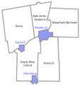 Oxford County municipal boundaries today, as established in 1975.
Demographics
| Canada census – Oxford County, Ontario community profile | |||
|---|---|---|---|
| 2011 | 2006 | 2001 | |
| Population: | 105,719 (2.9% from 2006) | 102,756 (3.5% from 2001) | 99,270 (2.2% from 1996) |
| Land area: | 2,039.56 km2 (787.48 sq mi) | 2,039.46 km2 (787.44 sq mi) | 2,039.44 km2 (787.43 sq mi) |
| Population density: | 51.8/km2 (134/sq mi) | 50.4/km2 (131/sq mi) | 48.7/km2 (126/sq mi) |
| Median age: | 39.8 (M: 38.6, F: 40.9) | 37.7 (M: 36.6, F: 38.7) | |
| Total private dwellings: | 43,367 | 40,625 | 38,555 |
| Median household income: | |||
| References: 2011[1] 2006[2] 2001[3] | |||
Historic populations:[3]
- Population in 2001: 99,270
- Population in 1996: 97,142
Policing
Because of its designation as a regional municipality, Oxford County has a regional-level police force, titled the Woodstock Police Service. However, a few communities such as Ingersoll, Norwich and Tillsonburg are patrolled by the Ontario Provincial Police (OPP) Oxford detachment, with Ingersoll formerly having its own independent police service for many years before merging with the OPP.[4] Recently many townships opted to remove OCPS from service and now relies upon the OPP. OCPS has become the Woodstock Police Service and now only serves inside Woostock city limits.
See also
References
- 1 2 3 "Oxford County census profile". 2011 Census of Population. Statistics Canada. Retrieved 2012-03-27.
- ↑ "2006 Community Profiles". Canada 2006 Census. Statistics Canada. March 30, 2011. Retrieved 2012-03-27.
- 1 2 "2001 Community Profiles". Canada 2001 Census. Statistics Canada. February 17, 2012. Retrieved 2012-03-27.
- ↑ www.cooloxford.ca
External links
| Wikimedia Commons has media related to Oxford County, Ontario. |
- County of Oxford, Ontario Canada Official website
- Information Oxford
- Oxford County: History
- McGill University, The Digital Collections Program: 1880 map of Ontario Counties
 |
Perth County | Waterloo Regional Municipality | | |
| Middlesex County | |
County of Brant | ||
| ||||
| | ||||
| Elgin County | |
Norfolk County |
| Regions | |
|---|---|
| Counties | |
| Districts | |
| Regional municipalities | |
| Single-tier municipalities | |
| Separated municipalities | |
| |