St. Thomas, Ontario
| St. Thomas | |
|---|---|
| City (single-tier) | |
| City of St. Thomas | |
|
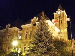
St. Thomas City Hall, designated a National Historic Site | |
 | |
 St. Thomas | |
| Coordinates: 42°46.5′N 81°11′W / 42.7750°N 81.183°WCoordinates: 42°46.5′N 81°11′W / 42.7750°N 81.183°W | |
| Country |
|
| Province |
|
| County | Elgin |
| Settled | 1810 |
| Incorporated | 1852 (Village) |
|
1861 (town) 1881 (city) | |
| Government | |
| • Mayor | Heather Jackson |
| • Governing Body | St. Thomas City Council |
| • MPs | Karen Vecchio (CPC) |
| • MPPs | Jeff Yurek (OPC) |
| Area[1] | |
| • Land | 35.52 km2 (13.71 sq mi) |
| Elevation[2] | 209.10 m (686.02 ft) |
| Population (2011)[1] | |
| • Total | 37,905 |
| • Density | 1,067.3/km2 (2,764/sq mi) |
| Time zone | EST (UTC-5) |
| • Summer (DST) | EDT (UTC-4) |
| Postal code span | N5P, N5R |
| Area code(s) | 519 and 226 |
| Highways |
|
| Website | http://stthomas.ca/ |
St. Thomas (2011 population 37,905) is a city in Southwestern Ontario, Canada. It gained its city charter on March 4, 1881. The city is also the seat for Elgin County, although it is independent of the county. It is part of the London census metropolitan area.
History
The city, located at the intersection of two historical roads, was first settled in 1810. It was named the seat of the new Elgin County in 1844 and was incorporated as a village in 1852, as a town in 1861. In 1881 St. Thomas became a city. It was named after Thomas Talbot[3] who helped promote the development of this region during the early 19th century.
The founder of the settlement that became St. Thomas was Capt. Daniel Rapelje, descendant of a Walloon family settled in New Amsterdam, now New York City, at its inception in the seventeenth century.[4] In 1820, Rapelje, the town's first settler, divided his land into town lots suitable for a village. Owner of the New England Mill, Rapelje subsequently donated two acres of land for the building of Old St. Thomas Church.[5]
In 1871, the developing village of Millersburg, which included these lands east of the London and Port Stanley Railway, amalgamated with St. Thomas.[6]
In the late 19th century and early 20th century several railways were constructed through the city, and St. Thomas became an important railway junction. A total of 26 railways have passed through the city since the first railway was completed in 1856. In the 1950s and 1960s, with the decline of the railway as a mode of transportation, other industry began to locate in the city, principally primary and secondary automotive manufacturing.

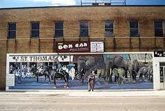
Jumbo the circus elephant died here on September 15, 1885, when hit by a locomotive following a performance. There is a life-sized commemorative statue that was erected in 1985.
In 1824, Charles Duncombe and John Rolph established the first medical school in Upper Canada, in St. Thomas, under the patronage of Colonel Thomas Talbot.[7] Duncombe's house now forms part of The Elgin Military Museum complex. Between 1881 and 1988 the city had a private woman's school operating called Alma College which was destroyed by fire in 2008.
St. Thomas' late 19th- early 20th century architecture includes the Elgin County Court House, Wellington Street public school, Myrtle St. School (demolished in 2014), Balaclava St. School, Elmdale School and its city hall, most designated heritage properties and all designed by former resident Neil R. Darrach.
Government
Heather Jackson is the current mayor of St. Thomas. The City Council consists of the mayor and seven aldermen, all elected at large, meaning that there are no wards and councillors are elected on a citywide basis.
Military
31 Combat Engineer Regiment (The Elgins) was created in 1997 when the former Elgin Regiment (RCAC) was re-roled from an armour tasking. The regiment had been associated with St. Thomas since its creation; St. Thomas is currently home to one of its two component field squadrons.[8] St. Thomas Armoury is a recognized Federal Heritage building 1992 on the Register of the Government of Canada Heritage Buildings.[9]
Demographics
According to the 2011 census, St. Thomas had a population of 37,905 people in 2011, which was an increase of 5.6% from the 2006 census count. The median household income in 2006 for St. Thomas was $54,876, which is below the Ontario provincial average of $60,455.[10]
95.5% of the population is Caucasian, 1.2% Aboriginal, and 3.3% Visible minorities.
Religious affiliation is 52.1% Protestant, 21% Catholic, 22.1% No affiliation and 4.8% Other.
Population trend:[11]
- Population in 2011: 37,905
- Population in 2006: 36,110
- Population in 2001: 33,236 (or 33,303 when adjusted to 2006 boundaries)
- Population in 1996: 32,275 (or 31,407 when adjusted to 2001 boundaries)
- Population in 1991: 30,332
Education
Fanshawe College has a satellite campus in St. Thomas. Catholic schools are controlled by the London District Catholic School Board and public schools are controlled by the Thames Valley District School Board. Arthur Voaden Secondary School, Central Elgin Collegiate Institute and Parkside Collegiate Institute are the three public high schools. St. Joseph's High School is a Catholic high school. There are two independent Christian elementary schools, St. Thomas Community Christian School and Faith Christian Academy. Algoma University has a campus in St. Thomas that offers the first two years of selected Bachelor of Arts courses, after the two years students transfer to Algoma's main campus.
Economy
The local economy has been dominated by automotive manufacturing, with two plants operated by Magna International, the Ford St. Thomas Assembly in nearby Talbotville, and the Sterling Trucks plant. However, the recent global recession that impacted the auto sector ultimately trickled down to the city; the Sterling plant closed in March 2009, and the Ford plant closed in late 2011. This had a domino effect on the other part manufacturers in town, such as Lear Seating. One automotive materials supplier, A. Schulman, had previously closed its local manufacturing plant in 2008, one of the first actions of a new CEO installed in January.[12]
Masco Canada's consolidation of their Canadian operations into the former Sterling Truck assembly plant in 2010[13] and Toyota supplier Takumi Stamping Canada's expansion in the same year[14] brought over 500 jobs to St. Thomas.
Transportation

St. Thomas is accessible via The Kings Highway 3 and The Kings Highway 4, the latter of which provides access to London, Highway 401 and Highway 402.
St. Thomas Transit, which includes both conventional bus service and paratransit, is owned by the city and staffed and operated by Voyageur Transportation.
The city is served by the St. Thomas Municipal Airport (YQS), just east in the Municipality of Central Elgin. There are no scheduled flights, the airport is used for general aviation only. A bi-annual large-scale air show takes place at the St. Thomas Municipal Airport.
 |
Strathroy via Highway 4 and Highway 402 |
London via Highbury Avenue and Wellington Road |
Belmont via Highway 3 |
|
| Sarnia via Highway 4 and Highway 402 |
|
Aylmer via Highway 3 | ||
| ||||
| | ||||
| Chatham via Highway 4 and Highway 401 |
Port Stanley via Highway 4 |
Port Bruce via Highway 3 and Elgin County Road 73 |
Media
St. Thomas has several media outlets based in the city. The St. Thomas Times-Journal is the city's newspaper, owned by Sun Media (Quebecor). The St. Thomas - Elgin Weekly News is a weekly newspaper published in St. Thomas, that is distributed for free to all residents of St. Thomas and Elgin County. The Elgin County Market is a weekly publication that is also distributed for free to all residents of St. Thomas and Elgin County, it features various local business flyers and advertisements.
Rogers Cable operates a local community channel consisting mostly of local and dedicated volunteers. CFPL-DT, branded as CTV Two London, covers many news stories from St. Thomas.
St. Thomas's only local commercial radio station, CKZM-FM 94.1 FM was launched on May 20, 2011. Also a low-power FM radio station — VF8016, 90.1 MHz — broadcasts religious activities from Faith Baptist Church of St. Thomas. CFHK-FM, branded as 103.1 Fresh FM, is also licensed to St. Thomas, although its programming originates from London and targets all of southwestern Ontario.
Sports
There is a dragway called St. Thomas Raceway Park. The dragway is located a reasonable distance away from the town and minutes east of the historical community of Sparta.
Climate
| Climate data for St. Thomas, Ontario (1981−2010) | |||||||||||||
|---|---|---|---|---|---|---|---|---|---|---|---|---|---|
| Month | Jan | Feb | Mar | Apr | May | Jun | Jul | Aug | Sep | Oct | Nov | Dec | Year |
| Record high °C (°F) | 14.5 (58.1) |
18.5 (65.3) |
24.5 (76.1) |
29.5 (85.1) |
32.5 (90.5) |
38.0 (100.4) |
37.0 (98.6) |
34.5 (94.1) |
33.0 (91.4) |
26.5 (79.7) |
21.5 (70.7) |
18.5 (65.3) |
38.0 (100.4) |
| Average high °C (°F) | −0.8 (30.6) |
0.7 (33.3) |
5.6 (42.1) |
13.0 (55.4) |
19.6 (67.3) |
24.7 (76.5) |
27.0 (80.6) |
25.9 (78.6) |
21.8 (71.2) |
15.1 (59.2) |
8.3 (46.9) |
2.0 (35.6) |
13.6 (56.5) |
| Daily mean °C (°F) | −4.7 (23.5) |
−3.6 (25.5) |
1.0 (33.8) |
7.6 (45.7) |
13.7 (56.7) |
18.8 (65.8) |
21.2 (70.2) |
20.3 (68.5) |
16.4 (61.5) |
10.1 (50.2) |
4.5 (40.1) |
−1.4 (29.5) |
8.7 (47.7) |
| Average low °C (°F) | −8.5 (16.7) |
−7.8 (18) |
−3.7 (25.3) |
2.1 (35.8) |
7.7 (45.9) |
12.9 (55.2) |
15.4 (59.7) |
14.7 (58.5) |
10.9 (51.6) |
5.1 (41.2) |
0.6 (33.1) |
−4.8 (23.4) |
3.7 (38.7) |
| Record low °C (°F) | −31 (−24) |
−30 (−22) |
−25.5 (−13.9) |
−16 (3) |
−3 (27) |
1.0 (33.8) |
6.0 (42.8) |
0.0 (32) |
−2 (28) |
−7 (19) |
−13.5 (7.7) |
−27.5 (−17.5) |
−31 (−24) |
| Average precipitation mm (inches) | 73.5 (2.894) |
63.2 (2.488) |
65.7 (2.587) |
83.4 (3.283) |
87.3 (3.437) |
92.4 (3.638) |
83.0 (3.268) |
80.0 (3.15) |
94.8 (3.732) |
85.7 (3.374) |
98.7 (3.886) |
85.3 (3.358) |
993.0 (39.094) |
| Average rainfall mm (inches) | 35.2 (1.386) |
37.3 (1.469) |
48.5 (1.909) |
79.9 (3.146) |
87.3 (3.437) |
92.4 (3.638) |
83.0 (3.268) |
80.0 (3.15) |
94.8 (3.732) |
85.4 (3.362) |
92.4 (3.638) |
58.1 (2.287) |
874.4 (34.425) |
| Average snowfall cm (inches) | 38.3 (15.08) |
25.9 (10.2) |
17.1 (6.73) |
3.5 (1.38) |
0.0 (0) |
0.0 (0) |
0.0 (0) |
0.0 (0) |
0.0 (0) |
0.3 (0.12) |
6.3 (2.48) |
27.3 (10.75) |
118.6 (46.69) |
| Average precipitation days (≥ 0.2 mm) | 14.7 | 11.4 | 12.1 | 15.2 | 14.1 | 11.1 | 12.4 | 11.1 | 13.2 | 13.9 | 15.3 | 14.5 | 159.0 |
| Average rainy days (≥ 0.2 mm) | 6.0 | 5.7 | 9.1 | 14.3 | 14.1 | 11.1 | 12.4 | 11.1 | 13.2 | 13.9 | 13.5 | 8.5 | 132.9 |
| Average snowy days (≥ 0.2 cm) | 9.6 | 7.0 | 4.2 | 1.3 | 0.0 | 0.0 | 0.0 | 0.0 | 0.0 | 0.15 | 2.3 | 7.3 | 31.8 |
| Source: Environment Canada[2] | |||||||||||||
Parks


There are two major parks in the city: Pinafore Park in the south, beside Pinafore Lake; and Waterworks Park in the north, which is straddled by Kettle Creek and the Waterworks Reservoir nearby.
The Trans Canada Trail goes through St. Thomas, with a pavilion located in Jonas Street Park.
The Lions Club Dog Park is located at the far west end of main street, at 25 Talbot Road. The park is managed by the St. Thomas Dog Owners Association (STDOA) in partnership with the City of St. Thomas. The park is open from dawn to dusk, daily.
The Kettle Creek Dog Park, opened in July 2014, is located just north of St Thomas, off Highbury on Mapleton Line, 200 metres beyond Dan Paterson Conservation Area. The park is open daily from dawn to dusk and boasts a large fenced in park, a fenced in area for small dogs and a separate fenced in area for one on one play. The park is managed by Kettle Creek Conservation Authority in partnership with STDOA, the Municipality of Central Elgin and the City of St Thomas.
V.A. Barrie Park, located on Sunset Drive, and Waterworks Park include popular Disc Golf courses.
Cultural activities
The Elgin Military Museum is located in the west end of St. Thomas. While the museum recounts the stories of Elgin County residents from the War of 1812 to Afghanistan, it also includes two M113 Armoured Personnel Carriers and a collection of some 600 UN and NATO badges described by one appraiser as "the best collection I have seen outside of the UN in New York". In late 2009, The Elgin Military Museum began the process to acquire the Cold War Oberon Class Submarine HMCS Ojibwa, The submarine is planned to be stationed outside of St. Thomas in Port Burwell.
The Elgin County Railway Museum is located in central St. Thomas.
St. Thomas is also home to the North America Railway Hall of Fame, which is located in the CASO train station. The station was built in the 1870s and was a centre of travel between New York City and Chicago. It is located on Talbot Street downtown.
The Elgin Theatre Guild is located at 40 Princess Avenue, and is home to a thriving community theatre, as well as hosting small musical groups. The building is a former church, built in 1907 by architect Neil Darrach. In 2001, St. Thomas City Council designated 40 Princess Avenue as a building of historic and architectural value in the City of St. Thomas.
St. Thomas is home to the Railway City Brewing Company, one of 29 members of the Ontario Craft Brewers.
St. Thomas' sister city is Bowling Green, OH.[15]
Notable people
- Jess Allen, co-host of The Social talk show
- Bob Emslie, (January 27, 1859 – April 26, 1943) pitcher in Major League Baseball (MLB) who went on to set numerous records for longevity as an umpire
- Cory Emmerton, professional ice hockey player (Detroit Red Wings, Grand Rapids Griffins, Kingston Frontenacs)
- Jack Graney, professional baseball player and broadcaster, namesake of the Jack Graney Award
- Paul Hackman (1953–1992), guitarist and songwriter from the rock band Helix
- Libby Hague, artist
- Gopal Bhatnagar, Canadian Cardiac Surgeon, Entrepreneur and Public Health Advocate
- Dell Henderson, Hollywood actor of 304 films, director of 208 films and writer of 35.
- Mitchell Hepburn (August 12, 1896 – January 5, 1953), Premier of Ontario 1934-1942
- Dave Hudson, former professional ice hockey player (New York Islanders, Kansas City Scouts, Colorado Rockies)
- DJ Kennington, NASCAR Nationwide Series driver
- Rachel McAdams, Oscar-nominated Hollywood actress
- Greg McKegg, professional ice hockey player for the Florida Panthers
- Stephen Ouimette, actor, director widely known for his work at the Stratford Festival of Canada
- Stephen J. Peters, politician, MPP for Elgin—Middlesex—London, former Minister of Labour (Ontario) and Minister of Agriculture and Food (Ontario), Speaker of the Ontario Legislature 2007-2011.
- Philip Francis Pocock, former Catholic archbishop of Toronto
- Janet and Greta Podleski, bestselling cookbook authors (Looneyspoons, Crazy Plates, Eat, Shrink & Be Merry!), Food Network hosts and Reader's Digest columnists
- Joe Preston, entrepreneur and member of parliament representing Elgin—Middlesex—London riding.
- John Wise (Ontario), PC (December 12, 1935 – January 9, 2013) was a Canadian dairy cattle farmer and Federal Minister of Agriculture.
- Capt. Daniel Rapelje, (1774–1828), born in New York State, founder of St. Thomas, Ontario
- Helen Shaver, actress, director, producer (The Amityville Horror, The Color of Money, Judging Amy)
- Ned Sparks, (November 19, 1883 – April 3, 1957) Character actor, well known for his deadpan expression and deep gravelly voice.
- David Shaw, former professional ice hockey player
- Kenneth J. Summers, commander of Operation Friction.
- Joe Thornton, professional ice hockey player (San Jose Sharks, Boston Bruins, Sault Ste. Marie Greyhounds, St. Thomas Stars)
- Aaron Walpole, the third-place finisher in the third season of Canadian Idol
- Kari-Lynn Winters, children's book author, dramatist, literacy educator
- Marline Yan (1993-), actress and singer
See also
References
- 1 2 "St. Thomas community profile". 2011 Census data. Statistics Canada. Retrieved 2012-02-08.
- 1 2 "St. Thomas WPCP". Canadian Climate Normals 1981–2010. Environment Canada. Retrieved April 12, 2014.
- ↑ Rayburn, Alan (1997), Place Names of Ontario, University of Toronto Press, Pg. 304 ISBN 0-8020-7207-0
- ↑ "Capt. Daniel Rapelje, 1774–1828". Ontarioplaques.com. Retrieved 2012-06-07.
- ↑ History of St. Thomas Church Begins with Rapelje
- ↑ Archived December 11, 2008, at the Wayback Machine.
- ↑ "Archived copy". Archived from the original on June 15, 2011. Retrieved October 18, 2009.
- ↑ "31 Combat Engineer Regiment (The Elgins)". Army.ca. 2006-11-29. Retrieved 2012-06-07.
- ↑ Register of the Government of Canada Heritage Buildings.
- ↑ "St. Thomas community profile". 2006 Census data. Statistics Canada. Retrieved 2011-02-11.
- ↑ Statistics Canada: 1996, 2001, 2006 census
- ↑ Steve Minter (17 March 2010). "On the Rise -- A. Schulman Inc.: Molding a Global Strategy". Industry Week (IW). Penton Media. Archived from the original on 6 August 2010. Retrieved 6 August 2010.
- ↑ "Masco Moves More Business to St. Thomas | St. Thomas EDC". St-thomas.org. Retrieved 2012-06-07.
- ↑ "Takumi Stamping Canada Inc. expands in St. Thomas | St. Thomas EDC". St-thomas.org. Retrieved 2012-06-07.
- ↑ http://www.bgsu.edu/downloads/cas/file38948.pdf[]
External links
| Wikimedia Commons has media related to St. Thomas, Ontario. |
| |
Central Elgin | | ||
| Southwold | |
Central Elgin | ||
| ||||
| | ||||
| Central Elgin |
| Regions | |
|---|---|
| Counties | |
| Districts | |
| Regional municipalities | |
| Single-tier municipalities | |
| Separated municipalities | |
| |