Paugussett Trail
| Paugussett Trail | |
|---|---|
|
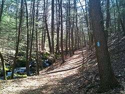
The Paugussett Trail parallels Round Hill Brook in Webb Mountain Park, Monroe, Connecticut. | |
| Length | 9.1 mi (14.6 km) |
| Location | Monroe / Shelton, Connecticut, USA |
| Designation | CFPA Blue-Blazed Paugussett Trail |
| Use | hiking, cross-country skiing, snowshoeing, other |
| Elevation | |
| Highest point | Webb Mountain Park, 417 ft (127 m) |
| Lowest point | Connecticut Route 34, Lake Zoar and Stevenson Dam (41°23′N 73°10′W / 41.38°N 73.16°WCoordinates: 41°23′N 73°10′W / 41.38°N 73.16°W), 59 ft (18 m) |
| Hiking details | |
| Trail difficulty | easy, with very few difficult sections |
| Season | easiest spring to fall |
| Hazards | hunters, deer ticks, poison ivy |
The Paugussett Trail is a 9.2-mile (14.8 km) Blue-Blazed hiking trail "system" in the lower Housatonic River valley in Fairfield County and, today, is entirely in Shelton and Monroe, Connecticut. Much of the trail is in Indian Well State Park and the Town of Monroe's Webb Mountain Park. The mainline (official "Blue-Blazed") trail is primarily southeast to northwest with three short side or spur trails.
The Paugussett Trail today is composed of four (4) trails of which one is the upside-down V-shaped Southeast-to-North-to-SouthWest mainline trail (9.1 miles) plus three shorter side or access spur trails. The northernmost point on the trail is at Connecticut Route 34 and Lake Zoar's southern shore.
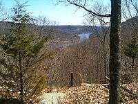
Notable features include the initial steep climb near the Indian Well waterfall, a steep climb with stairs at Princess Wenonah Drive and semi-obscured scenic views of the Housatonic River.[1] The Paugussett Trail is maintained largely through the efforts of the Connecticut Forest and Park Association.
The Paugussett Trail was a much larger trail in the 1930s and 1940s but it has been one of the Blue-Blazed Trails most drastically shrunk by post-World War 2 housing developments.
Trail description

The Paugussett Trail extends from its southern terminus at Indian Well Road in Indian Well State Park in Shelton, then follows a route north along the western bank of the Housatonic River until it turns south-west just before reaching Connecticut Route 34 (and the southern shore of Lake Zoar). The northern terminus is on East Village Road near its intersection with Barn Hill Road in the East Village section of Monroe. Today's Paugussett Trail passes through just the municipalities of Shelton and Monroe—both in Fairfield County.
The Paugussett Trail is primarily used for hiking, backpacking, picnicking, and in the winter, snowshoeing. Portions of the trail are suitable for, and are used for, geocaching, mountain biking and cross-country skiing. Site-specific activities enjoyed along the route include hunting (very limited), fishing, horseback riding, bouldering and rock climbing (access). There are signs at the Connecticut Indian Well State Park Paugussett trail head forbidding rock climbing near the Indian Well waterfall.
Trail route

The official Paugussett Trail mainline trail in Shelton primarily parallels the Housatonic River on the high western bank and ridge running south to north. The Monroe section continues following the Housatonic River but turns northwest until it reaches the Stevenson Dam at the southern end of Lake Zoar, after which the Paugussett Trail turns south-southwest following a stream called Boys Halfway River.
The Paugussett Trail traverses several ridges scenic views of the Housatonic River though they may be obscured by foliage, particularly in the summer.
Several year-round and seasonal streams cut across the trail to flow into the Housatonic River including Indian Hole Brook, White Hill Brook, White Hill Community Brook, Round Hill Brook and Boys Halfway River.
The Paugussett Trail crosses Indian Well State Park and Birchbank Mountain Open Space in Shelton, and Webb Mountain Park in Monroe.
By adding reasonably short road walks the Paugussett Trail is considered part of the larger Lake Zoar Blue-Blazed Trails which span both the west and east banks of Lake Zoar. The Kettletown State Park trails can be reached via a road walk by following Connecticut Route 34 east over the Stevenson Dam, then following Copper Mine Road to Freeman Road to Fiddlehead Road. Zoar Trail in lower Paugussett State Forest can be reached via a road walk by following Connecticut Route 34 west to Great Quarter Road (just over the Newtown border).
There are several trails in Shelton and Monroe which cross and connect with the Paugussett Trail including the Birchbank Mountain White Trail (a part of Paugussett Blue-Blazed Trail until ruinous ATV ruts caused the Connecticut Forest and Park Association to abandon it[2]) and the Webb Mountain Trails.
Trail communities
The official Blue-Blazed Paugussett Trail passes through land located within the following municipalities, from south to north: Shelton, Connecticut, Monroe, Connecticut[1][3]
Remnants of the original Paugussett Trail still exist as local trails in the communities of Monroe, Connecticut, Shelton, Connecticut and Stratford, Connecticut.
History and folklore
The Paugussett Blue-Blazed Trail was originally created with the help of the Great Depression era Civilian Conservation Corps (CCC) while Indian Well State Park was a Works Projects Administration (WPA) project.[4]
Indian Well in Shelton is named the pool beneath the waterfall at the entrance to the state park as well as for the legend of a Native American tragic romance between a Paugussett brave and a Pootatuck maiden.[5]
The route of the original and planned (longer) Paugussett trail blazed can be seen in the Connecticut Forest and Park Association 1940 Connecticut Walk Book map of major trails.[6]
In 1946,[7] before the building of Aspetuck Village (and other housing developments) the Paugussett Trail crossed the entire length of Shelton, Connecticut rather than ending near the Connecticut Route 110 entrance to Indian Well State Park. It left Shelton just below the Trap Falls Reservoir, entering into Stratford at the town-owned Roosevelt Forest (bordered by Trumbull and Shelton, located near Connecticut Route 8 exit 11).
Trail volunteers in Shelton hope to connect the Paugussett Trail to the Shelton Lakes Greenway trails and from there to Stratford, Connecticut.[8]
Roosevelt Forest in Stratford was purchased and developed as a project by the Works Projects Administration (WPA) during the Great Depression and is named after President Franklin D. Roosevelt. It has been expanded in recent times by the addition of land, including a few acres across the border in Shelton. It contains many hiking trails. Note that only cars with Town of Stratford resident stickers are officially allowed parking privileges inside Roosevelt Forest (others are supposed to pay a non-resident fee though this may not be enforced).[9]
Origin and name
Paugussett is the name of an Algonquian-speaking[10] native American tribe and sachemdom existing in southwestern Connecticut in the 17th century.
Derby Connecticut was once known as "Paugussett" before it was renamed in 1675.
Paugussett villages existed in Bridgeport, Trumbull, Stratford, Shelton, Monroe and Oxford in Fairfield County as well as in what is now Milford, Orange, Woodbridge, Beacon Falls, Derby and Naugatuck in New Haven County, Connecticut. The Naugatuck were a branch of the Paugussett.[11]
Descendants of the southeast Fairfield County Connecticut branch of the Paugussett tribe (known as the "Golden Hill" Paugussetts) today have a reservation in Colchester Connecticut (New London County) as well as a small land holding in the Nichols section of Trumbull, Connecticut.[12]
For more information on the Paugussett native-Americans ("American Indians") see the Wikipedia entry on the Paugussett as well as the Golden Hill Paugussett website.
Historic sites
Lake Zoar was created in 1919 by the construction of the Stevenson Dam to produce hydro-electric power and to provide Housatonic River vehicle crossing.[13]
Lake Housatonic is the Housatonic River section south of the Stevenson Dam which parallels the Paugussett Trail which was created by the construction of the Derby Dam (now known as the Lake Housatonic Dam) in October 1870 to provide a river crossing as well as water for nearby industry.[14]
Webb Mountain Park was a farm owned by the Mr. and Mrs. Alfred E. Wagner which was purchased by the Town of Monroe in 1972.[15]
Hiking the trail

The mainline Paugussett trail is blazed with blue rectangles. It is regularly maintained, and is considered easy hiking, with very few sections of rugged and moderately difficult hiking (notably the initial steep climb near the Indian Well waterfall and the steep climb using "stairs" between two suburban houses at Princess Wenonah Drive in Shelton).
Much of the Paugussett Trail is close to public roads. There are limited camping facilities in Webb Mountain Park (reservations required) along the trail and camping is prohibited in Indian Well State Park. Trail descriptions are available from a number of commercial and non-commercial sources, and a complete guidebook is published by the Connecticut Forest and Park Association
Weather along the route is typical of Connecticut. Conditions on exposed ridge tops and summits may be harsher during cold or stormy weather.[16] Lightning is a hazard on exposed summits and ledges during thunderstorms. Snow is common in the winter and may necessitate the use of snowshoes. Ice can form on exposed ledges and summits, making hiking dangerous without special equipment. [17]
Extensive flooding in ponds, puddles and streams may occur in the late winter or early spring, overflowing into the trail and causing very muddy conditions. In this case fairly high waterproof boots are recommended. Some parts of the trail follow forest roads which often contain ruts from ATVs and four-wheel drive vehicles.
Biting insects can be bothersome during warm weather. Parasitic deer ticks (which are known to carry Lyme disease) are a potential hazard.[17]
The mainline trailheads are very close to civilization (and state highways). Parts of the trail are very suburban, traveling on streets, cutting between yards or running behind back yards.
A very small part of the trail is adjacent to, or is on lands where hunting and the use of firearms are permitted. Wearing bright orange clothing during the hunting season (Fall through December) is recommended.
Conservation and maintenance of the trail corridor
See also
References
- 1 2 Connecticut Walk Book: A Trail Guide to the Connecticut Outdoors. 17th Edition. The Connecticut Forest and Park Association. Rockfall, Connecticut. Undated.
- ↑ http://www.sheltontrails.org/Birchbank.htm
- ↑ DeLorme Topo 6.0. Mapping Software. DeLorme, Yarmouth, Maine
- ↑ http://www.sheltonconservation.org/cri/housatonic_river.htm
- ↑ http://www.ct.gov/dep/cwp/view.asp?A=2716&Q=325226
- ↑ http://chriswoodside.com/files/imagecache/fullscreen/Connecticut%20Trail%20System,%201940.jpg
- ↑ http://borntoexplore.org/trails/paugussett.htm
- ↑ http://www.sheltonconservation.org/recreation/shelton_trails.html
- ↑ http://www.rooseveltforest.info/
- ↑ Trumbull, http://www.accessgenealogy.com/native/tribes/delaware/wappingerhist.htm
- ↑ http://www.accessgenealogy.com/native/newyork/newyork4.htm
- ↑ http://www.darkentry.org/paugussett2/historyhopes.htm
- ↑ A Fisheries Guide to Lakes and Ponds of Connecticut, published by the Department of Environmental Protection, Hartford, Connecticut, 2002
- ↑ http://oai.dtic.mil/oai/oai?verb=getRecord&metadataPrefix=html&identifier=ADA142592
- ↑ http://www.monroect.org/WebMountain.aspx
- ↑ NOAA
- 1 2 Metacomet Trail
External links
Specific to this trail:
- Shelton Trails website
- Shelton Trails -- Birchbank Mountain Open Space and White Trail
- Shelton Trails Blog
- Born To Explore / SheltonTrails.ORG - Paugussett Trail
- CT Museum Quest Article on Paugassett Trail
- NewEnglandSite.COM - Indian Well State Park
State and Municipal Government Websites:
- State of Connecticut - Indian Well State Park
- State of Connecticut - Indian Well State Park Hiking Map
- Town of Monroe, Connecticut website
- Town of Monroe, Connecticut -- Webb Mountain Park
- Town of Monroe, Connecticut -- Webb Mountain Park Trail Map
- City of Shelton, Connecticut website
- City of Shelton, Connecticut -- Points of Interest (and Trails) Map
- City of Shelton, Connecticut -- Conservation Commission
- City of Shelton, Connecticut -- Conservation Commission
- City of Shelton Conservation Committee -- Open Space Inventory Map
- Town of Stratford, Connecticut website
- Town of Stratford, Connecticut -- Roosevelt Forest
- Town of Stratford - Roosevelt Forest
- Golden Hill Paugussett website
Land Trusts / Conservation Preserves:
- Housatonic Valley Association
- Monroe Fields and Woods Association
- Shelton Land Conservation Trust, Inc.
- Shelton Land Conservation Trust -- Properties Map
- Connecticut Forest and Park Association
- Aquarion Water Company website
- Aquarion Water Company Recreation Information
Further reading
- Books – Connecticut Hiking
- Colson, Ann T. (2005). Connecticut Walk Book East (19 ed.). Rockfall, Connecticut: Connecticut Forest and Park Association. pp. 1–261. ISBN 0961905255.
- Colson, Ann T. (2006). Connecticut Walk Book West (19 ed.). Rockfall, Connecticut: Connecticut Forest and Park Association. pp. 1–353. ISBN 0961905263.
- Emblidge, David (1998). Hikes in southern New England: Connecticut, Massachusetts, Vermont (1 ed.). Mechanicsburg, Pennsylvania: Stackpole Books. pp. 1–304. ISBN 0-8117-2669-X.
- Keyarts, Eugene (2002). Pietrzyk, Cindi Dale, ed. Short Nature Walks: Connecticut Guide Book (7 ed.). Guilford, Connecticut: Falcon Publishing. pp. 1–192. ISBN 0-7627-2310-6.
- Laubach, Rene; Smith, Charles W. G. (2007). AMC's Best Day Hikes in Connecticut (1 ed.). Guilford, Connecticut: Appalachian Mountain Club Books. pp. 1–320. ISBN 1-934028-10-X.
- Ostertag, Rhonda; Ostertag, George (2002). Hiking Southern New England (2 ed.). Guilford, Connecticut: Falcon Publishing. pp. 1–336. ISBN 0-7627-2246-0.
- Books – Connecticut History and Geography
- De Forest, John (1853). History of the Indians of Connecticut from the earliest known period to 1850. Hartford, Connecticut: Wm. Jas. Hamersley. pp. 1–509.
- Hayward, John (1857). New England Gazetteer: Containing Descriptions of the States, Counties, Cities and Towns of New England (2 ed.). Boston, Massachusetts: Otis Clapp. pp. 1–704.
- Trumbull, Benjamin (1797). A Complete History of Connecticut - Civil and Ecclesiastical. Volume I (1818 printing ed.). New Haven, Connecticut: Maltby, Goldsmith & Co. and Samuel Wadsworth. pp. 1–1166.
- Trumbull, Benjamin (1797). A Complete History of Connecticut - Civil and Ecclesiastical. Volume II (1818 printing ed.). New Haven, Connecticut: Maltby, Goldsmith & Co. and Samuel Wadsworth. pp. 1–1166.
| ||