Washington–Rochambeau Revolutionary Route

The Washington–Rochambeau Revolutionary Route (W3R) is a 680-mile (1,094 km)-long series of roads used by the Continental Army under the command of George Washington and the Expédition Particulière under the command of Jean-Baptiste de Rochambeau during their 1781 march from Newport, Rhode Island, to Yorktown, Virginia, United States. The route is a designated National Historic Trail (2009) with interpretive literature, signs, and exhibits that describe the key role of French diplomatic, military, and economic aid to the United States during the American Revolutionary War.[1]
Background


In 1780, French King Louis XVI dispatched Rochambeau, 450 officers, and 5,300 men to aid Washington and the colonial forces. They arrived in Narragansett Bay off Newport, Rhode Island, on July 10, 1780.
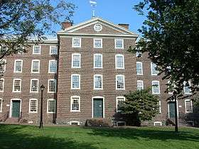
In June 1781, Rochambeau prepared to march from Rhode Island to join the Continental Army near White Plains, New York. He divided his force into four regiments: "Royal DeuxPonts" under the Baron de Viomenil; "Soissonnais" under the Baron's brother, Count de Viomenil; "Saintonge", under the Marquis de Custinel; and a fourth regiment. This final unit remained in Providence, where it guarded the baggage and munitions stored in the Old Market House, and supported the surgeons and attendants at the hospital in University Hall.
Judging from the maps in the Rochambeau Collection and the early maps of Providence, the French army started leaving, on June 19, the camp ground between Broad and Plane Streets, passed through the present Stewart Street to High Street, and west along this to the "junction" (Hoyle Tavern), where they took the road to the left, Cranston Street (then called the Monkey Town road) that went to Knightsville (then Monkeytown). They continued right, following the old Scituate road over Dugaway Hill past the late Pippin Orchard School house, over Apple House Hill, Bald Hill, crossing the Pawtuxet River at the village of Kent and on to Waterman's Tavern — a first day's march of 15 miles.[2]
The French forces marched across Connecticut to join George Washington on the Hudson River at Dobbs Ferry, New York. The advance party was led by Armand Louis de Gontaut or Duc de Lauzun. Lauzun's Legion marched ahead of the main army and stayed ten to fifteen miles (24 km) to the south protecting the exposed flank from the British.[3]
The combined American and French armies marched through New Jersey, Pennsylvania, Delaware, and Maryland, a route that allowed them to evade British troops. They reached Williamsburg, Virginia, in late September 1781.
On September 22, they combined with troops commanded by the Marquis de Lafayette.
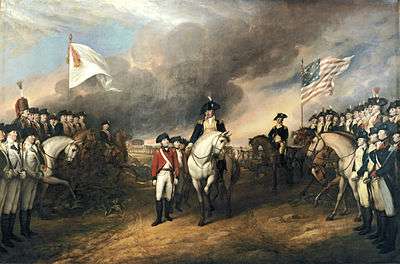
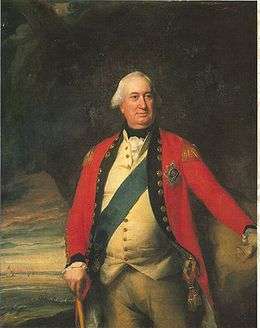
The French royal fleet blocked the Chesapeake, preventing the British from either delivering reinforcements from New York or evacuating General Cornwallis' army by sea. A three-week siege of Yorktown led to Cornwallis' surrender on October 19, 1781.
Washington's force then moved to defend northern posts. Rochambeau's force wintered in Williamsburg, then marched north in the summer of 1782 to Boston, Massachusetts. The return for both armies was much different than the original march by welcoming them as they passed every town and city along their return route.
Rochambeau and the French Troops in Providence in 1780-81-82 Howard W. Preston. (Read before the Rhode Island Historical Society, March 12, 1922.)
The Omnibus Public Land Management Act of 2009 signed on March 30, 2009, included a provision designating thge Washington–Rochambeau Revolutionary Route as a National Historic Trail.
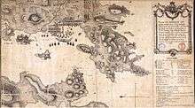
March route of the army of Rochambeau
Rhode Island to New York

Rochambeau and his general staff left the port of Newport, Rhode Island, on June 10, 1781, arriving at Providence the following day. The remainder of his force at Newport was transferred by boat and camped in Providence. Following a grand review of the French Army Providence on June 16, 1781, the French Army set out for Coventry, Rhode Island, in four divisions. One departed each day from June 18-21.
Each division had roughly the same amount of artillery, supplies, and a field hospital. Rochambeau himself left with the first division (the Bourbonnais Regiment) and arrived at the second camp site in Coventry in the evening of June 18 at a place known as Waterman's Tavern. The route between Providence and Coventry generally followed the alignment of Broadway in Providence to Olneyville, then Route 14 to the eastern side of the Scituate Reservoir. The original road is submerged in the reservoir but picks up again as Old Plainfield Pike in Scituate. West of Route 102 in Foster, the march route resumes following Route 14 into Coventry to the second camp.
Rochambeau's army marched from Coventry, through Sterling, Connecticut via Route 14A (Plainfield Pike) to the third camp in Plainfield opposite Plainfield Cemetery, arriving on June 19. A 3.6-mile portion of the march route between the 2nd and 3rd camps is listed on the National Register of Historic Places (NRHP). Its 2002 NRHP nomination document recorded that "the road retains its narrow, hilly, winding character, and for most of its length, the characteristic borders of stone walls remain in place."[4]:8 The French found this particular segment to be difficult for marching, resulting in the late arrival of some artillery and supply wagons at the Plainfield camp.
On June 20, Rochambeau's army continued their march along Route 14A to the town of Canterbury, then along Route 14, through Canterbury and Scotland. They arrived in the evening of June 20 at the fourth camp in Windham by the Shetucket River, just west of Windham Center. While most of Route 14A and Route 14 have lost their 18th-century visual character, several short road segments remain preserved. Some of these road segments have been listed on the National Register of Historic Places. On such segment is in western Plainfield, Old Canterbury Road, which was bypassed by state highway construction in the 1930s, preserves some of the features of the original roadway, including the low stone walls lining the road. The designated portion of the route also includes a 1,200-foot section of modern Route 14A east of the eastern end of Old Canterbury Road that maintains visual continuity of Old Canterbury Road. Another segment that was preserved as a result of being bypassed by the state highway is Manship Road and a portion of Barstow Road (between Manship Road and Route 14) in Canterbury, located midway between Canterbury Center and the village of Westminster. A segment of Route 14 east of Scotland Center has also been recognized as a preserved section of the march route. The designated segment runs from Miller Road to the top of a hill, about 800 feet east of Route 97. Known locally as Palmer Road, the low stone walls remain in place on both sides of this road segment and was described by the French as "a narrow, steep, and stony road". Yet another road segment between the 3rd and 4th camps is listed on the National Register, Scotland Road in Windham from Back Road to a point about 300 feet east of Ballahamack Road. This portion was one of the less difficult according to the French. While this road segment is mostly modern in appearance, the expansive views of the surrounding landscape, in addition to the preserved stone walls, contributes to the visual historical significance of the site.
The French army continued its march through Connecticut on June 21. Leaving the camp at Windham, the army went past the village of Willimantic, roughly following modern Route 14 and Route 66. The French proceeded through Columbia and Andover towards the fifth camp site in Bolton. The march route proceeded along Route 66 then Route 6 until roughly the northwest corner of Andover. From there, the original road to Bolton Center, where the fifth camp of the French army was located, has been unused since the late 19th century and has been overgrown by forest.
The following morning, on June 22, the French army continued its march from Bolton along Bolton Center Road (partly Route 85), continuing along Middle Turnpike East in Manchester until Route 6. From there the French followed Route 6 through Manchester Center to Silver Lane in East Hartford, where the sixth camp was located. The four divisions, which had been traveling a day apart, rested for three nights in East Hartford, necessitating additional camp sites in the same vicinity. Being a state highway trunkline route, the area surrounding Route 6 is heavily urbanized and has lost most of its historic character. However, in Andover and Bolton, two sections of the road that have been bypassed remain relatively preserved in their 18th century appearance. In Andover, the original march route (as well as the original Route 6) utilized what is now Hutchinson Road and Bailey Road. A segment of Hutchinson Road between Route 6 and Henderson Road retains the stone walls and mature trees along the side of the road, as well as the expansive views of open fields towards the Hop River. This road segment is listed on the National Register of Historic Places. The Daniel White Tavern, built in 1773 and used by French officers, still stands along this road segment. North of Henderson Road, Hutchinson Road has modern development and no longer has the visual continuity of the southern part of the road. Bailey Road originally connected Route 6 with Brandy Street in Bolton but the portion west of the Andover-Bolton town line has since been overgrown and is no longer passable by motor vehicles. A remnant of Bailey Road in Bolton (also listed on the National Register of Historic Places) still exists as an unpaved foot path and still retains the characteristic stone walls as well as two original stone culverts.
The first division of Rochambeau's army crossed the Connecticut River by ferry on June 25 into Hartford, with the other divisions following in one-day intervals as before. From there, they traveled along Farmington Avenue through West Hartford until Farmington, the site of the seventh camp. The camp site was located toward the south end of the town center village. Rochambeau and his officers are said to have stayed at the Elm Tree Inn. After staying overnight in Farmington Center, on June 26, the French army followed Route 10 through the town center of Southington until the Milldale section of town, then headed west along Route 322 until they reached the eighth camp site in the Marion section of Southington. Rochambeau and his officers stayed at the Asa Barnes Tavern. The following day, the French continued westward along Route 322, then Meriden Road into Waterbury. In Waterbury, the route followed East Main Street and West Main Street, crossing the Naugatuck River along the way. The road west of Waterbury was difficult and characterized by the French as being "détestables" for being very stony and mountainous. The route continued into present-day Middlebury, specifically the area around Breakneck Hill. The march route followed Park Road to Watertown Road, then turned south on Watertown Road until Breakneck Hill Road. The ninth camp was located at the foot of Breakneck Hill, where the first division stayed the night of June 27. Rochambeau and his officers were entertained at the Israel Bronson Tavern.
On June 28, the first division resumed its march heading south on Artillery Road and Middlebury Road (Route 64) through the town center of Middlebury, then continuing along Route 188 and Waterbury Road into the center of Southbury. The French army continued west along Main Street South and River Road through Southbury, crossing the Housatonic River into the town of Newtown using a bridge built in by the Colonial troops in 1778 at Glen Road. The French army continued along Church Hill Road through the center of Newtown where they set up their tenth camp west of the town center. The officers stayed in Caleb Baldwin's Tavern. Rochambeau reorganized his troops into two brigades in Newtown. The first division resumed its march on June 30 heading west on West Street and Castle Hill Road, then turning north along Reservoir Road and west again on Route 6. The Reservoir Road portion is well preserved and is listed on the National Register of Historic Places. The French army marched along Route 6 and Newtown Road into Danbury. In Danbury, the French troops used West Wooster Street, Park Avenue, and Backus Avenue to reach the Ridgebury section of the town of Ridgefield. The eleventh camp was set up on July 1 in Ridgebury near the Congregational Church.
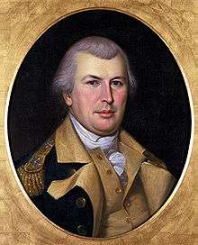
%2C_French_nobleman.jpg)
The French army resumed its march on the morning of July 2 through the town of Ridgefield, heading south on Ridgebury Road then turning west on Mopus Bridge Road. After crossing the New York state line, the French continued southwest and south following Route 121 past the hamlets of North Salem and Cross River until the hamlet of Bedford Village. The first brigade setup camp in Bedford Village (12th camp) and resumed the following day while the second brigade skipped the Bedford camp. The French continued west along Route 172 to what is now the village of Mount Kisco, about five miles away west of the Bedford camp. The French stayed in Mount Kisco for several days until the morning of July 6. They marched west and south for 16 miles along Route 133 and Route 100 to the Hartsdale area of the town of Greenburgh. The French camped in several locations in Greenburgh (14th camp) for the next six weeks.
See also
- List of historic sites preserved along Rochambeau's route
- British colonization of the Americas
- Colonial America
- Colonial American military history
- Colonial history of the United States
- Historic regions of the United States
- James Manning
- James Mitchell Varnum
- Joseph Webb House
- King's Highway (Charleston to Boston)
- Jean Baptiste, marquis de Traversay
- Louis Marc Antoine de Noailles
- Charles Armand Tuffin
- François-Joseph Paul
Notes
- ↑ "Washington-Rochambeau National Historic Trail (U.S. National Park Service)". Nps.gov. 2016-03-16. Retrieved 2016-07-01.
- ↑ Rhode Island Historical Society Collections, XVII, No. 1 (January 1924).
- ↑ Life and Letters of Samuel Holden Parsons, Major General in the Continental Army and Chief Judge of the Northwestern Territory 1737 — 1789, Charles S. Hall 1905, page 364
- ↑ Mary Harper and Bruce Clouette (December 2002). "National Register of Historic Places Registration: March Route of Rochambeau's Army: Plainfield Pike" (PDF). National Park Service. and Accompanying 14 photos, from 2001
References
- Charles S. Hall, Life and Letters of Samuel Holden Parsons, Ostenigo Publishing Co., Binghamton, NY, 1905
External links
- Washington-Rochambeau National Historic Trail (National Park Service) Official website
- National Washington-Rochambeau Revolutionary Route Association
- State-by-state Google Maps of the Route
- "Washington–Rochambeau Revolutionary Route Study", NPS
- "The Washington-Rochambeau Route Markers", The Historical Marker Database
- The Long March to Yorktown by Donald N. Moran