Lillinonah Trail
Coordinates: 41°28′N 73°19′W / 41.46°N 73.31°W
| Lillinonah Trail | |
|---|---|
|
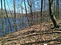
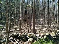
Lake Lillinonah from the Lillinonah Trail, Newtown, Connecticut. | |
| Length | 5.9 miles (9.5 km)[1] |
| Location | Newtown, Connecticut |
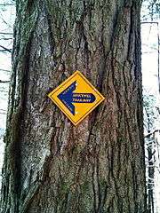
| Designation | CFPA Blue-Blazed Trail |
| Trailheads |
Hanover Road (near State boat launch on Pond Brook) Echo Valley Road parking lot for Paugussett State Forest Upper Block |
| Use | hiking, cross-country skiing, snowshoeing, fishing, other |
| Elevation | |
| Highest point | Upper Paugussett State Forest, 480 ft (150 m) |
| Lowest point | Lake Lillinonah at Shepaug Dam, 194 ft (59 m) |
| Hiking details | |
| Trail difficulty | easy, with very few difficult sections |
| Season | April 16 to December 14 |
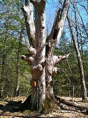
| Sights | Pond Brook inlet, Lake Lillinonah, Great Oak, Shepaug Dam, Maple Sugaring, Eagles |
| Hazards | hunters, deer ticks, poison ivy, Eagles |

The Lillinonah Trail is a 5.9-mile (9.5 km) Blue-Blazed hiking trail "system" in the lower Housatonic River valley in Fairfield County and, today, is entirely in Newtown. Most of the trail is in the upper block of Paugussett State Forest.
The mainline (official "Blue-Blazed") trail circles the Paugussett State Forest "upper block". The west, north and east portions of the trail are shared with the northern section of Al's Trail—a ten mile trail in Newtown.
The Lillinonah Trail today is composed of four sides in a square "loop".
Notable features include the Hanover Road parking lot and boat launch, semi-obscured (by trees) scenic views of Pond Brook inlet and Lake Lillinonah (Housatonic River), a climb to a high point of 480-foot (150 m), a very large oak tree, several stone fences and foundations and a demonstration of a maple sugaring technique known as "sugarbush" near the Echo Valley Road parking lot.[2] The Lillinonah Trail is maintained largely through the efforts of the Connecticut Forest and Park Association and the Newtown Forest Association.
The Lillinonah Trail appears to have been a larger trail in the 1940s based on the map in the 1940 CFPA Connecticut Walk Book.
Trail description

The squarish loop known as Lillinonah Trail extends from its eastern terminus at the junction of Hanover Road and Pond Brook Road in Newtown along the eastern bank of the Housatonic River inlet known as Pond brook until it turns north-east at Lake Lillinonah.
The Lillinonah Trail is primarily used for hiking, backpacking, picnicking, and in the winter, snowshoeing.
Portions of the trail are suitable for, and are used for, cross-country skiing. Site-specific activities enjoyed along the route include hunting (very limited), fishing, horseback riding, bouldering and rock climbing (limited). There are signs at the trail heads forbidding mountain biking but they are periodically ignored.
Trail route
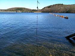
The western section of the Lillinonah Trail parallels Pond Brook on high eastern bank running south to north. The northern Lillinonah trail section follows the Housatonic River/Lake Lillinonah from west to east but turns inland to the southeast before the junction of the Housatonic River with the Shepaug River. Inland the trail traverses a hill to a high point of 480 feet and descends south-east until it reaches the western bank of the Housatonic River/Lake Lillinonah. The eastern section of the trail follows the western bank of the Housatonic River/Lake Lillinonah until just before a point on the shore to which is anchored a line of buoys to the Shepaug Dam at the southern end of Lake Lillinonah. The southern section of the Lillinonah Trail begins at the Paugussett State Forest parking lot at the end of Echo Valley Road. After skirting a private property lot it generally travel north and west along the Paugussett State Forest upper block boundary.
The Lillinonah Trail traverses several high river bank ridges with scenic views of the Housatonic River though they may be obscured by foliage, particularly in the summer. This 3.2 mile section of the trail near the river banks is designated a 'scenic trail' by the Connecticut Department of Environment Protection (and who close it from December 15 to March 15).
Several year-round and seasonal streams cut across the trail to flow into the Housatonic River.
The Lillinonah Trail travels near several "milepost" markers labeled with the letters "CL&P" (Connecticut Light and Power).
A few miles south of Lillinonah Trail on the Housatonic River can be found the Lake Zoar Blue-Blazed Trails which span both the west and east banks of Lake Zoar. The Zoar Trail is on the western bank of Lake Zoar in the lower block of the Paugussett State Forest in Newtown. The Kettletown State Park trails are on the eastern bank of Lake Zoar, primarily in Kettletown State Park (in Southbury.
'Al's Trail' overlaps with the Lillinonah Trail for the first four miles of each. The two separate shortly before the Lillinonah Trail reaches the Paugussett State Forest parking lot at the end of Echo Valley Road. Al's Trail continues for six more miles through Newtown, Connecticut, ending near the grounds of the former state mental institution known as "Fairfield Hills" (AKA Fairfield State Hospital). Newtown currently (2010) has a proposal to turn these former grounds into a town recreational with multi-use trails.
There are marked and unmarked trails and dirt forest roads which cross the interior of the Paugussett State Forest Upper Block, some of which connect to the Lillinonah Trail. The Polly Brody Fire Road is a wide dirt road which arcs from the end of Echo Valley Road through the center of the state forest block. A shared-use trail (mountain biking, horseback, & hiking) known as the Upper Gussy Trail has been built by members of the CT Chapter of the New England Mountain Bike Association and Newtown Bridle Lands Association. The Upper Gussy Trail is a State of Connecticut Department of Environmental Protection officially approved shared-use trail. The State DEP now has an official Upper Paugussett Trails Map with all the recognized trails in the forest. There are connectors between these trails (including the White Trail).
Trail communities
The official Blue-Blazed Lillinonah Trail passes through land only located within the municipality of Newtown, Connecticut.
The town of Southbury, Connecticut is visible from the trail across Lake Lillinonah on the eastern bank.
The border between Newtown and Southbury, as well as the border between Fairfield and New Haven counties, splits down the middle of Lake Lillinonah.
Landscape, geology, and natural environment
History and folklore
The Lillinonah Blue-Blazed Trail was created in the early 1940s by the Connecticut Forest and Park Association.
The route of the original and planned (longer) Lillinonah trail blazed can be seen in the Connecticut Forest and Park Association 1940 Connecticut Walk Book map of major trails.[3]
In 1872 the Shepaug, Litchfield and Northern Railroad (also known as the "Great Northern") from Bethel, Connecticut (by way of Hawleyville) ran track along Pond Brook to a Housatonic River bridge north to the Shepaug Valley (from which it wended a path to Litchfield, Connecticut).[4] The New York, New Haven and Hartford Railroad (AKA "The New Haven") leased the 32 mile long Shepaug line from 1892 to 1947. A twice-daily passenger service was discontinued in the 1930s and the line was completely shut down in 1948 at the request of the New York, New Haven and Hartford Railroad.[5]
Origin and name
Lake Lillinonah is named for the legend of a tragic romance between a Native American (of the Pootatuck / Paugussett tribe) maiden and a European (white) colonist.[6]
The Pootatuck (often spelled Pohtatuck in colonial era documents and related to the name Potatuck) were a branch of the Paugussett tribe who lived along the Housatonic and Pootatuck Rivers near the Sandy Hook area of Newtown, Connecticut (an area which was called "Pohtatuck" before the name was changed to "Sandy Hook"). It is unknown if a permanent Native American settlement existed at or near the upper block of Paugussett State Forest. Newtown, known as Quanneapague, was purchased from the Pohtatuck in 1705 and incorporated as a town in 1711. Most of the original settlers were farmers from Stratford and Milford, Connecticut.
Paugussett is the name of an Algonquian-speaking[7] native American tribe and sachemdom existing in southwestern Connecticut in the 17th century. Derby Connecticut was once known as "Paugussett" before it was renamed in 1675.
Paugussett villages existed in Bridgeport, Trumbull, Stratford, Shelton, Monroe and Oxford in Fairfield County as well as in what is now Milford, Orange, Woodbridge, Beacon Falls, Derby and Naugatuck in New Haven County, Connecticut. Pootatuck (AKA Potatuck) was a village of the Paugussett where the Pootatuck River is today in Newtown.[8]
Legend of Lillanonah
CONNECTICUT HISTORY |||Caves ||Steep Rock ||Chief Two Moons || LEGENDS |||| Lillinonah's Leap ||Leatherman ||Molly Fisher ||Pinnacle
LILLINONAH'S LEAP | When the English colonies in New England were very young, there was hardly an Indian between the Hudson and the Penobscot Rivers who did not know about Chief Waramaug, the great sachem of the Pootatuck tribe of western Connecticut. This is a legend about his daughter, Lillinonah.
Not only was Chief Waramug respected far and wide for his courage, wisdom and charismatic leadership, but he was also admired for his magnificent hilltop headquarters overlooking the Housatonic River, not far above the present town of New Milford. Called "Waramaug's Palace," the structure was said to have been at least twenty feet wide and a hundred feet long, a "long house," indeed, and unquestionably the largest Indian building ever constructed in New England. Made from bark and logs which had to be carried for many miles (mostly up hill) on the backs of the artisans who built it, Waramaug's Palace was famed both for its architectural grandeur and its ornate interior decoration. It is said, for example, that the walls of the cavernous main council chamber were covered with colorful paintings of the chief, members of his family, his councilors and judges, while smaller apartments were adorned from floor to ceiling with pictures of all the beasts, birds, reptiles and insects to be found in the land of the Pootatucks.
As proud as Waramaug was of his imposing palace, he was even prouder of the light of his life, his lovely daughter, Lillinonah. Taught from birth to cultivate those virtues most revered by her father -- compassion for one's fellow man, loyalty to family and tribe and sensitivity to the beauties of Nature -- Lillinonah was, at the age of eighteen, a young woman whose humanity matched her grace and beauty. From near and far the young braves came, as moths to the flame, to pay homage to Lillinonah -- and perhaps win her hand in marriage. But first, of course, each had to pass muster with old Waramaug, and that was no simple matter.
Now it happened that on a cold and wintry day, as Lillinonah was out walking in the woods high above the swift rapids of the Housatonic, she came upon a handsome young white man wandering aimlessly through the forest, stumbling occasionally and falling to his knees before rising once more and continuing on. It was obvious to the Indian maiden that the man was sick with cold and fever, weak of body and confused of mind. With pity in her heart for the suffering stranger, she offered to assist him back to the village of the Pootatucks, where he might find rest and treatment for his illness. When the white man nodded his assent, she slowly walked him to her home, though he had to lean heavily upon her for support, lest he collapse in the effort.
Although the elders of the village did not approve and did nothing to help her, Lillinonah nursed the stricken Englishman through all the rest of the long, cold winter, seldom leaving his side. As spring came to the encampment of the Pootatucks, he was well along the road to recovery, thanks to the care of his attentive nurse and the good medicine which she had provided. With the blossoming of the mountain laurel on the banks of the Housatonic, love, too, bloomed in the house of Lillinonah. As the beautiful daughter of Waramaug gazed with undisguised affection into the eyes of the man whose life she had saved, she saw that he returned her adoration with unaffected ardor. When summer came, the two young lovers finally decided that they must go to Chief Waramaug, for a love as deep as theirs must be consummated by marriage. The great sachem's reaction, however, was as they both expected: he was very angry. With all the eligible Indian suitors for miles around still beating a path to her door, how dare Lillinonah ask for his blessing on a union with a white man, an unknown stranger whose culture was so different from her own? Was it not true that the paleface despised the Indians, regarding them as little better than the savage beasts of the forest? No, said Waramaug, never would he sanction Lillinonah's marriage to such a man.
But Lillinonah refused to eat or drink. Her once lovely face turned sallow and she began to shrink before the very eyes of her distraught father. As summer waned, the once beautiful daughter of Waramaug became a pale shadow of her former self, so great was her pain and powerful her will. Finally, although he still regarded marriage between his daughter and a white man as a burden almost too heavy to bear, Waramaug relented. Reluctantly, he consented to the marriage of his beloved Lillinonah to the man she had found lost in the woods on that long ago winter's day. Before the marriage could take place, the betrothed couple agreed, the fair young man should return to his own people, to let them know that he was still alive and well, and to tell them of his plans to wed Lillinonah and live for the rest of his life in the company of the Pootatucks. Both lovers realized that his people would urge him not to go back to his lovely Indian princess. They would remind him that there were plenty of young English women in the colonies just looking for a husband as attractive as he was. What right had he to wed a dusky maid from a foreign and inferior race? But he promised Lillinonah that no argument would ever persuade him to break their vow to marry. After one final winter with his own people, he would return to Lillinonah -- in the early spring. Sadly, he took his leave.
The autumn passed, and winter, too, and as the first green began to show in the hickory and oak along the Housatonic, Lillinonah bedecked herself with the wild flowers of the forest as she waited in happy anticipation for her lover's return. But summer came and went, the reds and yellows of autumn showed bright on the trees, and still the young Englishman had not come back to the land of the Pootatucks. Lillinonah no longer sang a joyous song. There were no more flowers in her hair. Wan and listless, she wandered through the woods, her eyes red-rimmed from weeping, searching and hoping against hope that she had not been forgotten.
Chief Waramaug watched sadly as once more his daughter's health began to fail and her usually happy disposition to turn morose under mounting waves of despondency. Perhaps, he thought, he might bring her back from the brink of deep depression if he could only interest her in a young man of her own race. So, unknown to Lillinonah, Waramaug arranged a marriage for her with Eagle Feather, one of the brightest, most promising braves in the Pootatuck tribe. Surely, such a fine youth as he, could give Lillinonah something to live for.
But word reached Lillinonah of her father's arrangement with Eagle Feather -- and she reacted immediately. Down on the shore of the Housatonic River, now rapid and swollen with the heavy rains of autumn, she climbed into a canoe and shoved off into the teeth of the roaring current. As the canoe was carried faster and faster toward the turbulent waters above the dangerous falls of the river, Lillinonah tossed away her paddle and sank back in the bottom of the canoe to await her fate.
Then, high on a crag jutting over the river just above the cataract, she saw him! Her lost lover had not forgotten. Even above the roar of the water she heard him call her name. She stood in the canoe, waved her arms and screamed for help. Though he knew his chances of saving his beloved were slim at best, the young Englishman did not hesitate for a moment. He leaped from the overhanging bluff and plunged into the whitened water, just as Lillinonah's canoe struck a rock in the middle of the river and capsized, spilling her into the frothy current. Swiftly as he could, he swam to her side and clasped her body to him. Alas, neither realized that it was already too late. Still wrapped in loving embrace, the doomed pair disappeared into the boiling falls and were crushed to death as they were hurled to the rocks in the broad pool below.
They say that when the battered bodies of the star-crossed lovers were finally found, they were still locked in each other's arms. Noble, even in deepest mourning for his lost Lillinonah, Chief Waramaug ordered that his daughter and her white lover be buried side by side, contrary to Indian tradition, on the top of a hill overlooking the narrow gap of the Housatonic River now known as Lover's Leap. And when old Waramaug finally joined his ancestors many sad years later, legend says that he, too, was laid to rest near the ill-fated couple. Though the tragic life of Lillinonah ended centuries ago, her legend will never be forgotten. Any Connecticut map will show that the wide portion of the Housatonic River which stretches for miles below the narrow rapids where the lovers met their deaths is, to this day, still called Lake Lillinonah.
from Legendary Connecticut by David E. Philips / $17.95
Descendants of the southeast Fairfield County Connecticut branch of the Paugussett tribe (known as the "Golden Hill" Paugussetts) today have a reservation in Colchester Connecticut (New London County) as well as a small land holding in the Nichols section of Stratford, Connecticut.[9]
For more information on the Paugussett native-Americans ("American Indians") see the Wikipedia entry on the Paugussett as well as the Golden Hill Paugussett website.
Historic sites
Lake Lillinonah was created in 1955 by damming the Housatonic River via the construction of the Shepaug Dam (another "Shepaug Reservoir Dam" stands upstream on the Shepaug River and is owned by the City of Waterbury, Connecticut) to produce hydro-electric power. The reservoir was prematurely and accidentally flooded by Hurricane Diane on August 19, 1955 a few weeks before the dam was scheduled to commence operation. The lake was drained and refilled again beginning on September 27, 1955 by closing the gates on the new dam.[10]
In 1985 Shepaug Dam owners opened a free public observation site in Southbury, Connecticut near the hydroelectric generation plant for viewing Lake Lillinonah's Bald Eagles (and other predatory bird species such as hawks). Reservations are required and the season is limited to the last weekend in December until March 17 on Wednesdays, Saturdays and Sundays from 9 a.m. until 1 p.m.[11]
Hiking the trail
The mainline Lillinonah trail is blazed with blue rectangles. It is regularly maintained, and is considered easy hiking, with very few sections of rugged and moderately difficult hiking (notably just the climb up to the northern high point near the great Oak tree).
Much of the Lillinonah Trail is close to water and though some swamp areas inland are prone to flooding the trail along the lake shore is mostly on very high ground. There are no camping facilities along the trail and camping is prohibited in the Paugussett State Forest Upper Block. Trail descriptions are available from a number of commercial and non-commercial sources, and a complete guidebook is published by the Connecticut Forest and Park Association
Weather along the route is typical of Connecticut. Conditions on exposed ridge tops and summits may be harsher during cold or stormy weather.[12] Lightning is a hazard on exposed summits and ledges during thunderstorms. Snow is common in the winter and may necessitate the use of snowshoes. Ice can form on exposed ledges and summits, making hiking dangerous without special equipment. [13]
Extensive flooding in ponds, puddles and streams may occur in the late winter or early spring, overflowing into the trail and causing very muddy conditions. In this case fairly high waterproof boots are recommended. Some parts of the trail follow forest roads which often contain ruts from ATVs and four-wheel drive vehicles.
Biting insects can be bothersome during warm weather. Parasitic deer ticks (which are known to carry Lyme disease) are a potential hazard.[13]
Only the trail heads are close to (rural) civilization (and paved roads). There is only one very short dirt road walk—along Echo Valley Road.
Almost all of the trail is adjacent to, or is on lands where hunting and the use of firearms are permitted. Wearing bright orange clothing during the hunting season (Fall through December) is recommended. Note that much of the trail is closed from December 15 to March 15 for the protection of Eagles during their nesting season.
Conservation and maintenance of the trail corridor

See also
References
- ↑ Colson, Ann T. (2006). Connecticut Walk Book West (19th edition). Connecticut Forest and Park Association. ISBN 0-9619052-6-3.
- ↑ Connecticut Walk Book: A Trail Guide to the Connecticut Outdoors. 17th Edition. The Connecticut Forest and Park Association. Rockfall, Connecticut. Undated.
- ↑ http://chriswoodside.com/files/imagecache/fullscreen/Connecticut%20Trail%20System,%201940.jpg
- ↑ http://www.hvceo.org/luchange_newtown.php
- ↑ http://www.hvceo.org/transport/railhistory.php#ABANDONED
- ↑ http://www.ct.gov/dep/cwp/view.asp?A=2716&Q=325226
- ↑ Trumbull, http://www.accessgenealogy.com/native/tribes/delaware/wappingerhist.htm
- ↑ http://www.accessgenealogy.com/native/newyork/newyork4.htm
- ↑ http://www.darkentry.org/paugussett2/historyhopes.htm
- ↑ http://www.newstimes.com/news/article/Lake-Lillinonah-has-colorful-history-55777.php
- ↑ http://www.firstlightpower.com/eagles/viewing_shepaug.asp
- ↑ NOAA
- 1 2 Metacomet Trail
External links
Specific to this trail:
- CT Museum Quest Article on the Lillinonah Trail
- Berkshire Hiking Website page on "Paugussett State Forest Hiking Trail"
- HikeCT page on the Lillinonah Trail
Connecticut State Government links:
- State of Connecticut - Upper Paugussett State Forest
- State of Connecticut - Upper Paugussett State Forest Hiking Map
- State of Connecticut - Upper Paugussett State Forest Hunting/Topological Map
- Connecticut State Forests - Seedling Letterbox Series - Clues for Paugussett State Forest
History:
- Connecticut Forest and Park Association
- Town of Newtown, Connecticut
- Newtown Historical Society
- History of Newtown, Connecticut
- The Shepaug Valley Railroad AKA Shepaug Line
- The Legend of Lake Lillinonah By David E. Philips
- Housatonic Valley Council of Elected Officials - Land Usage Change in Newtown, CT
Land Trust / Conservation Preserve Organizations:
- Connecticut Forest and Park Association
- Friends of the Lake (FOTL)
- Housatonic Valley Association
- Lake Lillinonah Authority
- Newtown Forest Association, Inc.
- Newtown Forest Association - Al's Trail Association
- Newtown Forest Association - Al's Trail Map
News Articles:
- FirstLight Power Resources, a GDF SUEZ Energy North America company - Shepaug Dam operator/owner
- 25th Year Anniversary of Shepaug Bald Eagle Observation Area in Southbury, CT
- News Times: Lake Lillinonah debris spark debate
Further reading
- Books – Connecticut Hiking
- Colson, Ann T. (2005). Connecticut Walk Book East (19 ed.). Rockfall, Connecticut: Connecticut Forest and Park Association. pp. 1–261. ISBN 0961905255.
- Colson, Ann T. (2006). Connecticut Walk Book West (19 ed.). Rockfall, Connecticut: Connecticut Forest and Park Association. pp. 1–353. ISBN 0961905263.
- Emblidge, David (1998). Hikes in southern New England: Connecticut, Massachusetts, Vermont (1 ed.). Mechanicsburg, Pennsylvania: Stackpole Books. pp. 1–304. ISBN 0-8117-2669-X.
- Keyarts, Eugene (2002). Pietrzyk, Cindi Dale, ed. Short Nature Walks: Connecticut Guide Book (7 ed.). Guilford, Connecticut: Falcon Publishing. pp. 1–192. ISBN 0-7627-2310-6.
- Laubach, Rene; Smith, Charles W. G. (2007). AMC's Best Day Hikes in Connecticut (1 ed.). Guilford, Connecticut: Appalachian Mountain Club Books. pp. 1–320. ISBN 1-934028-10-X.
- Ostertag, Rhonda; Ostertag, George (2002). Hiking Southern New England (2 ed.). Guilford, Connecticut: Falcon Publishing. pp. 1–336. ISBN 0-7627-2246-0.
- Books – Connecticut History and Geography
- De Forest, John (1853). History of the Indians of Connecticut from the earliest known period to 1850. Hartford, Connecticut: Wm. Jas. Hamersley. pp. 1–509.
- Hayward, John (1857). New England Gazetteer: Containing Descriptions of the States, Counties, Cities and Towns of New England (2 ed.). Boston, Massachusetts: Otis Clapp. pp. 1–704.
- Trumbull, Benjamin (1797). A Complete History of Connecticut - Civil and Ecclesiastical. Volume I (1818 printing ed.). New Haven, Connecticut: Maltby, Goldsmith & Co. and Samuel Wadsworth. pp. 1–1166.
- Trumbull, Benjamin (1797). A Complete History of Connecticut - Civil and Ecclesiastical. Volume II (1818 printing ed.). New Haven, Connecticut: Maltby, Goldsmith & Co. and Samuel Wadsworth. pp. 1–1166.
| ||