Larkin State Park Trail
| Larkin State Park Trail | |
| Connecticut State Park | |
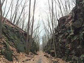 Looking west on the trail in Middlebury | |
| Country | |
|---|---|
| State | |
| County | New Haven |
| Towns | Southbury, Oxford, Middlebury, Naugatuck |
| Coordinates | 41°28′21″N 73°12′25″W / 41.47250°N 73.20694°WCoordinates: 41°28′21″N 73°12′25″W / 41.47250°N 73.20694°W |
| Area | 110 acres (45 ha) [1] |
| Gifted to state | 1943 |
| Management | Connecticut Department of Energy and Environmental Protection |
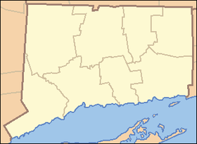 Location in Connecticut | |
| Website: Larkin State Park Trail | |
Larkin State Park Trail is a Connecticut rail trail that follows the former New York & New England Railroad roadbed across the towns of Southbury, Oxford, Middlebury, and Naugatuck. The trail is 10.3 miles (16.6 km) long; its eastern terminus is at Whittemore Glen State Park, the western at Kettletown Road in Southbury. The trail is open for hiking, biking, horseback riding, and cross-country skiing.[2]
History
The rail line was in operation from 1881 until 1939. Four years after the line's abandonment, Dr. Charles L. Larkin bought a ten-mile section that he donated to the state for the purpose of creating an equestrian trail. The park was named in his honor.[2]
References
- ↑ Legislative Program Review and Investigations Committee (January 23, 2014). "State Parks and Forests: Funding" (PDF). Staff Findings and Recommendations. Connecticut General Assembly. p. A-1. Retrieved March 20, 2014.
- 1 2 "Larkin State Park Trail". State Parks and Forests. Connecticut Department of Energy and Environmental Protection. Retrieved February 5, 2013.
External links
- Larkin State Park Trail Connecticut Department of Energy and Environmental Protection
- Larkin State Park Trail Map - Eastern Section Connecticut Department of Energy and Environmental Protection
- Larkin State Park Trail Map - Western Section Connecticut Department of Energy and Environmental Protection
| ||
This article is issued from Wikipedia - version of the 7/13/2016. The text is available under the Creative Commons Attribution/Share Alike but additional terms may apply for the media files.