Windsor Locks Canal State Park Trail
| Windsor Locks Canal State Park Trail | |
| Connecticut State Park | |
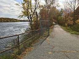 View looking south at the Connecticut River and Windsor Locks Canal State Park Trail from the northern trail head in Suffield, Connecticut. | |
| Country | |
|---|---|
| State | |
| County | Hartford |
| Towns | Windsor Locks, Suffield |
| Coordinates | 41°59′11″N 72°36′19″W / 41.98639°N 72.60528°WCoordinates: 41°59′11″N 72°36′19″W / 41.98639°N 72.60528°W |
| Established | Unspecified |
| Management | Connecticut Department of Energy and Environmental Protection |
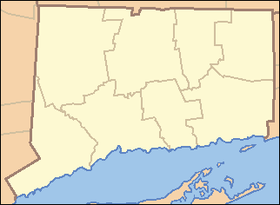 Location in Connecticut | |
| Website: Windsor Locks Canal State Park Trail | |
Windsor Locks Canal State Park Trail runs 4.5 miles (7.2 km) along the towpath of the historic Enfield Falls Canal on the Connecticut River from Suffield south to Windsor Locks, Connecticut. A modern paved surface covers the original dirt towpath. The park can be used for fishing, hiking, and biking.[1]
References
- ↑ "Windsor Locks Canal State Park Trail". State Parks and Forests. Connecticut Department of Energy and Environmental Protection. Retrieved February 5, 2013.
External links
- Windsor Locks Canal State Park Trail Connecticut Department of Energy and Environmental Protection
This article is issued from Wikipedia - version of the 11/2/2016. The text is available under the Creative Commons Attribution/Share Alike but additional terms may apply for the media files.