Mattatuck Trail
| Mattatuck Trail | |
|---|---|
|
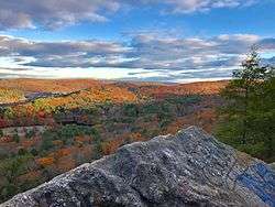
Scenic view north from the Mattatuck Trail at the top of Black Rock (in Black Rock State Park, Watertown, Connecticut). | |
| Length | 36.0 miles (57.9 km) [1] |
| Location | Wolcott,Plymouth, Thomaston, Watertown, Morris, Litchfield, Cornwall Connecticut |
| Designation | CFPA Blue-Blazed Trail |
| Use | hiking, cross-country skiing, snowshoeing, fishing, mountain biking (parts of the trail), other |
| Elevation | |
| Highest point | Mohawk Mountain, 1,683 ft (513 m) |
| Lowest point | Naugatuck River, 347 ft (106 m) |
| Hiking details | |
| Trail difficulty | Easy, Strenuous |
| Season | All |
| Months | 12 |
| Sights | Buttermilk Falls, Indian Jack Cave, Leatherman's Cave, Crane's Lookout, Prospect Mountain, Mohawk Mountain, Cunningham Tower |
| Hazards | hunters, deer ticks, poison ivy |
Mattatuck Trail is an 36.0-mile (57.9 km) Blue-Blazed hiking trail in Litchfield County, Connecticut.
The mainline (official "Blue" "non-dot") trail is fragmented linear trail with a northern trail head which terminates at the Mohawk Trail.
See also
References
Further reading
- Books – Connecticut Hiking
- Colson, Ann T. (2005). Connecticut Walk Book East (19 ed.). Rockfall, Connecticut: Connecticut Forest and Park Association. pp. 1–261. ISBN 0961905255.
- Colson, Ann T. (2006). Connecticut Walk Book West (19 ed.). Rockfall, Connecticut: Connecticut Forest and Park Association. pp. 1–353. ISBN 0961905263.
- Emblidge, David (1998). Hikes in southern New England: Connecticut, Massachusetts, Vermont (1 ed.). Mechanicsburg, Pennsylvania: Stackpole Books. pp. 1–304. ISBN 0-8117-2669-X.
- Keyarts, Eugene (2002). Pietrzyk, Cindi Dale, ed. Short Nature Walks: Connecticut Guide Book (7 ed.). Guilford, Connecticut: Falcon Publishing. pp. 1–192. ISBN 0-7627-2310-6.
- Laubach, Rene; Smith, Charles W. G. (2007). AMC's Best Day Hikes in Connecticut (1 ed.). Guilford, Connecticut: Appalachian Mountain Club Books. pp. 1–320. ISBN 1-934028-10-X.
- Ostertag, Rhonda; Ostertag, George (2002). Hiking Southern New England (2 ed.). Guilford, Connecticut: Falcon Publishing. pp. 1–336. ISBN 0-7627-2246-0.
- Books – Connecticut History and Geography
- De Forest, John (1853). History of the Indians of Connecticut from the earliest known period to 1850. Hartford, Connecticut: Wm. Jas. Hamersley. pp. 1–509.
- Hayward, John (1857). New England Gazetteer: Containing Descriptions of the States, Counties, Cities and Towns of New England (2 ed.). Boston, Massachusetts: Otis Clapp. pp. 1–704.
- Trumbull, Benjamin (1797). A Complete History of Connecticut - Civil and Ecclesiastical. Volume I (1818 printing ed.). New Haven, Connecticut: Maltby, Goldsmith & Co. and Samuel Wadsworth. pp. 1–1166.
- Trumbull, Benjamin (1797). A Complete History of Connecticut - Civil and Ecclesiastical. Volume II (1818 printing ed.). New Haven, Connecticut: Maltby, Goldsmith & Co. and Samuel Wadsworth. pp. 1–1166.
| ||
Coordinates: 41°49′19.6″N 73°17′55.2″W / 41.822111°N 73.298667°W
This article is issued from Wikipedia - version of the 11/11/2016. The text is available under the Creative Commons Attribution/Share Alike but additional terms may apply for the media files.